|

|
|
AGENDA
Ordinary Council Meeting
Tuesday, 5 May 2020
|
|
I hereby give notice that an Ordinary Meeting of
Council will be held on:
|
|
Date:
|
Tuesday, 5 May 2020
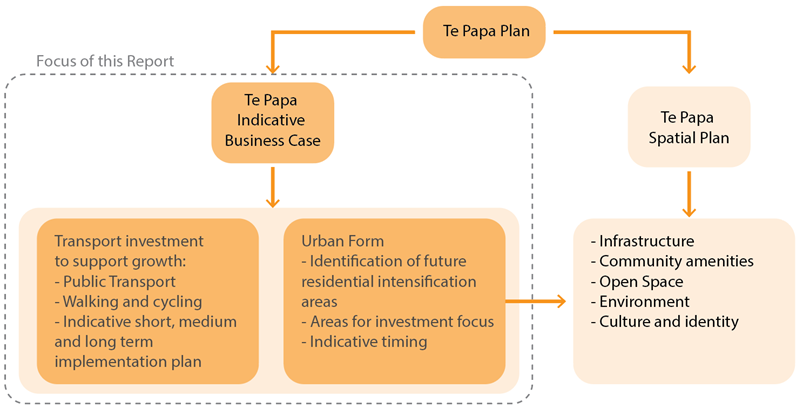
|
|
Time:
|
9am
|
|
Location:
|
Tauranga City Council
By video conference
|
|
Please
note that this meeting will be livestreamed and the recording will be
publicly available on Tauranga City Council's website: www.tauranga.govt.nz.
|
|
Marty Grenfell
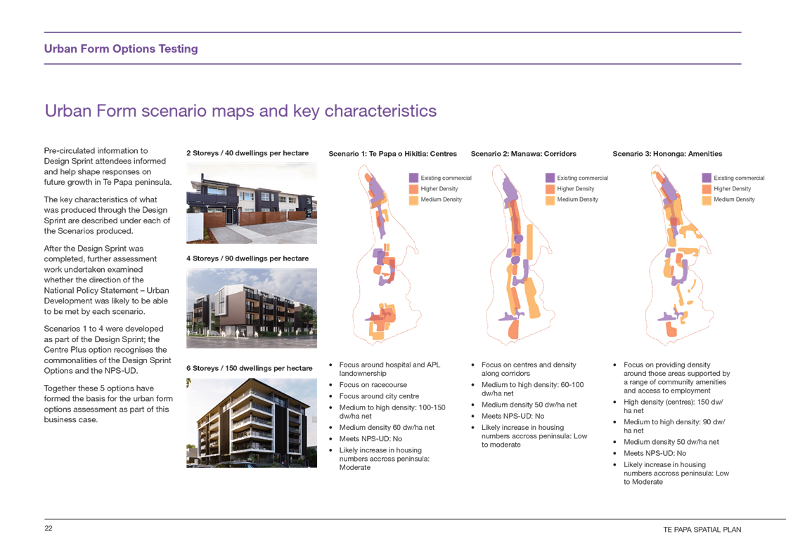
Chief Executive
|
Terms of reference – Council
Membership
|
Chairperson
|
Mayor Tenby Powell
|
|
Deputy chairperson
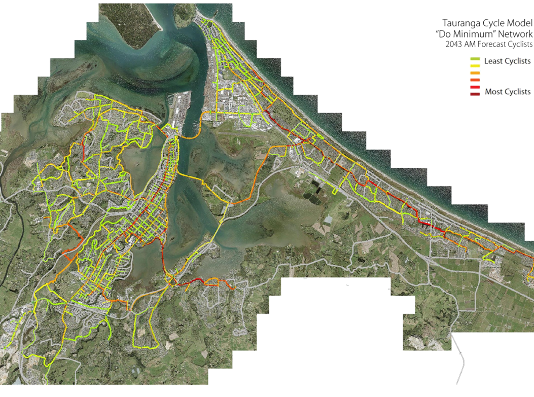
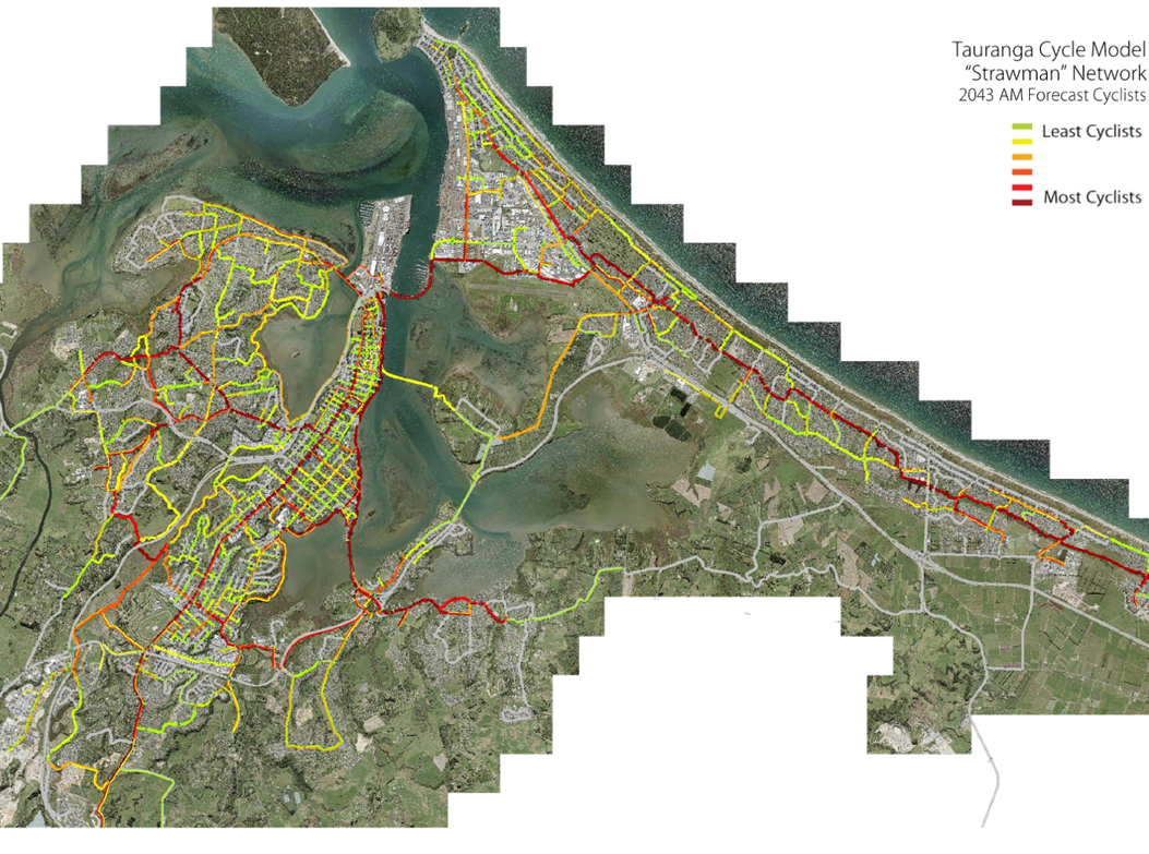
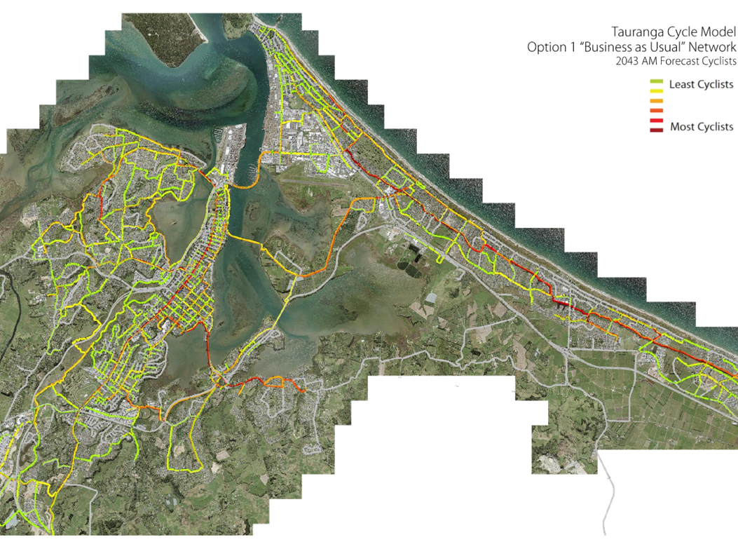
|
Cr Larry Baldock
|
|
Members
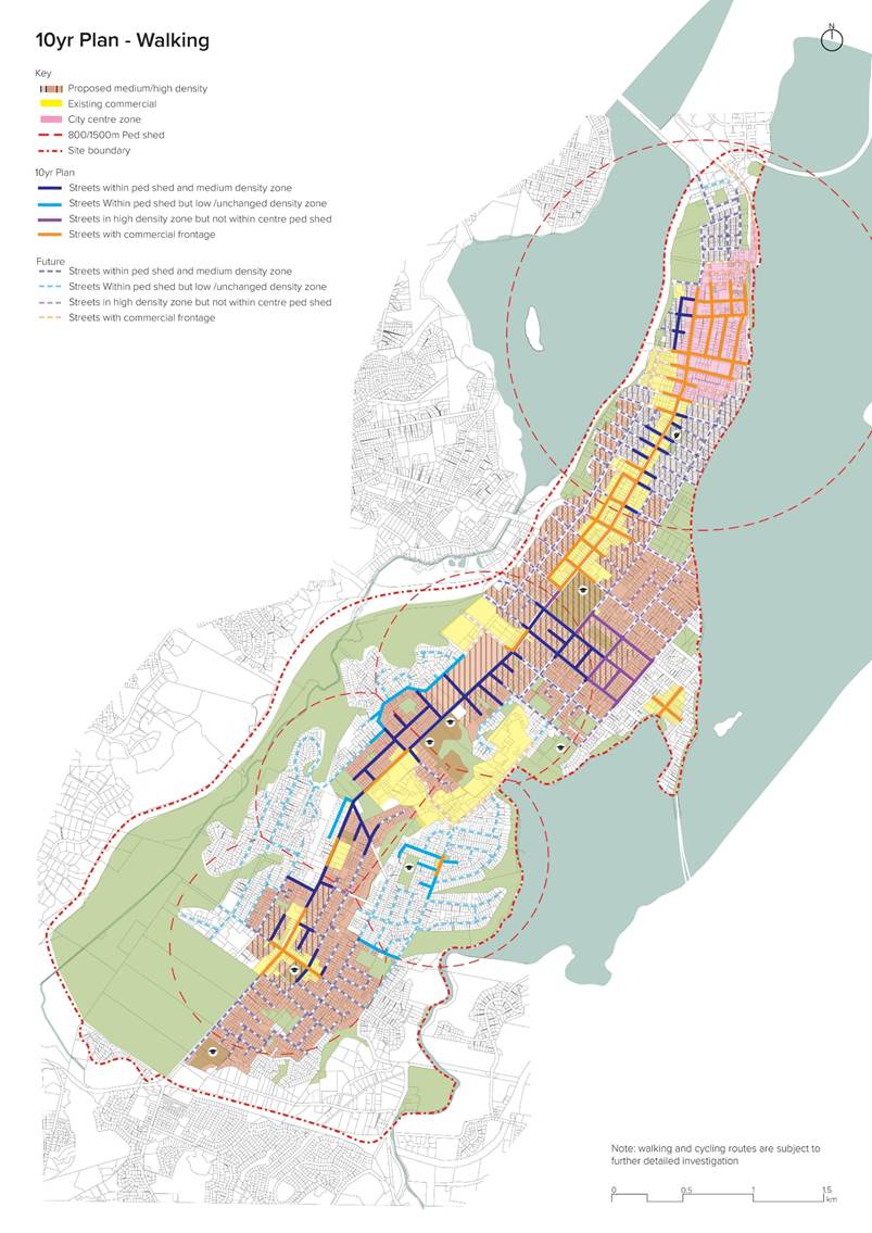
|
Cr Jako Abrie
Cr Kelvin Clout
Cr Bill Grainger
Cr Andrew Hollis
Cr Heidi Hughes
Cr Dawn Kiddie
Cr Steve Morris
|
|
Quorum
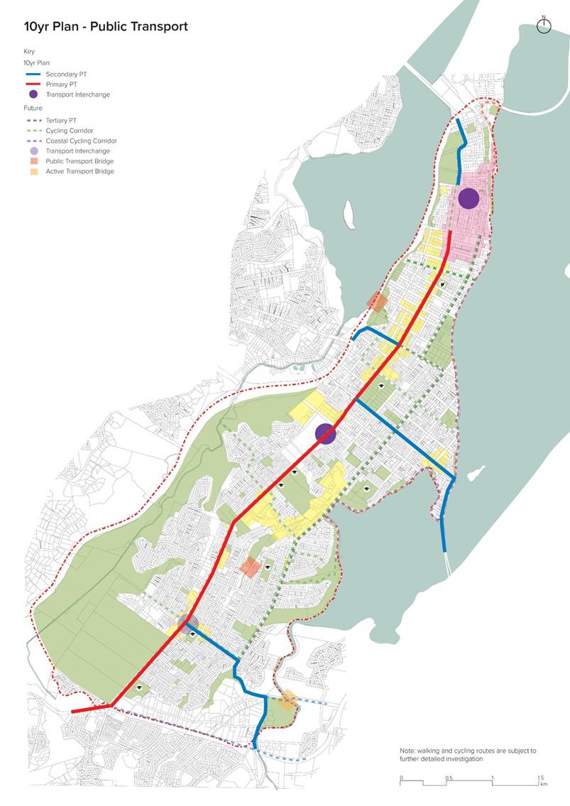
|
Half of the members physically present, where the
number of members (including vacancies) is even; and a majority
of the members physically present, where the number of members (including
vacancies) is odd.
|
|
Meeting
frequency
|
Six weekly or as required for Annual Plan, Long Term Plan
and other relevant legislative requirements.
|
Role
·
To ensure the effective and
efficient governance of the City
·
To enable leadership of the City
including advocacy and facilitation on behalf of the community.
Scope
·
Oversee the work of all
committees and subcommittees.
·
Exercise all non-delegable and
non-delegated functions and powers of the Council.
·
The powers Council is legally prohibited from delegating include:
o
Power to make a rate.
o
Power to make a bylaw.
o Power to borrow
money, or purchase or dispose of assets, other than in accordance with the
long-term plan.
o
Power to adopt a long-term plan, annual plan, or annual report
o
Power to appoint a chief executive.
o Power to adopt
policies required to be adopted and consulted on under the Local Government Act
2002 in association with the long-term plan or developed for the purpose of the
local governance statement.
o All final
decisions required to be made by resolution of the territorial
authority/Council pursuant to relevant legislation (for example: the approval
of the City Plan or City Plan changes as per section 34A Resource Management
Act 1991).
·
Council has chosen not to delegate the following:
o Power to
compulsorily acquire land under the Public Works Act 1981.
·
Make those decisions which are required by legislation to be made
by resolution of the local authority.
·
Authorise all expenditure not delegated to officers, Committees
or other subordinate decision-making bodies of Council.
·
Make appointments of members to the CCO Boards of
Directors/Trustees and representatives of Council to external organisations.
·
Consider any matters referred from any of the Standing or Special
Committees, Joint Committees, Chief Executive or General Managers.
Procedural matters
·
Delegation of Council powers to Council’s committees and
other subordinate decision-making bodies.
·
Adoption of Standing Orders.
·
Receipt of Joint Committee minutes.
·
Approval of Special Orders.
·
Employment of Chief Executive.
·
Other Delegations of Council’s powers, duties and
responsibilities.
Regulatory matters
Administration,
monitoring and enforcement of all regulatory matters that have not otherwise
been delegated or that are referred to Council for determination (by a
committee, subordinate decision-making body, Chief Executive or relevant
General Manager).
10 Business
10.1 Te
Papa Indicative Business Case
File
Number: A11387270
Author: Carl
Lucca, Programme Director: Urban Communities
Authoriser: Christine
Jones, General Manager: Strategy & Growth
Purpose of the Report
1. To
provide the Council an update on the Te Papa Indicative Business Case process
and seek approval to submit the Business Case to the New Zealand Transport
Agency (NZTA) for Approval in May 2020.
|
Recommendations
That the Council:
(a) Endorses
the recommended Te Papa peninsula urban form option.
(b) Agrees
in principle to the Te Papa peninsula 30-year multi-modal transport programme
to support the recommended urban form option, subject to further
investigation and funding availability
(c) Approves
the Te Papa Indicative Business Case be submitted to New Zealand Transport
Agency for consideration and approval in May 2020.
(d) Notes
that investment timing, costs and cost sharing are subject to further
investigations and agreement between the project partners and will come
before Council for approvals as the programme progresses.
|
Executive Summary
2. The
Te Papa project is made up of two core deliverables – the Te Papa Spatial
Plan, and the Te Papa Indicative Business Case (IBC). This report focuses on
the Indicative Business Case, including:
(a) An
overview of the options considered
(b) The
recommended ‘preferred way forward’ for urban form and the
supporting multi-modal transport programme
(c) A
detailed summary of the recommended multi-modal transport programme, including
indicative timing
(d) A
summary of potential benefits accruing from the recommended urban form and
multi-modal transport programme.
3. The
Te Papa IBC has been prepared by Tauranga City Council (TCC) in partnership
with NZTA and Bay of Plenty Regional Council. The IBC recommends an integrated
land use transport strategy that will increase opportunity for higher density
living in close proximity to centres, public transport and other amenities
along the Te Papa peninsula, supported by a sustained, balanced investment
programme in active modes and public transport infrastructure.
4. As
outlined on the NZ Treasury’s website, an Indicative Business Case
provides decision makers with an early indication of the preferred way forward
for high value and/or high risk investment proposals. It outlines how the
proposed investment fits within the organisation(s) strategic intentions;
confirms the need for investment and the case for change; and recommends an
indicative or preferred way forward for further development… The
information presented is indicative only. It provides the decision-makers
with just enough information to consider change and confirm the options being
considered, and an early opportunity to make a decision before too much work is
done.
5. Having
regard to the above, the purpose of the Te Papa IBC is to set in place an
agreed land use transport strategy that will form the basis for ongoing
collaboration between Tauranga City Council, Regional Council and central
government agencies to deliver an agreed vision for the Te Papa peninsula in
Tauranga City. Commitment to funding, timing and cost sharing will be subject
to more detailed planning which will come before Council for approvals as the
programme progresses.
6. The
scale of growth required in Te Papa and the wider city means significant
further investment in movement networks is needed. Relative to the
recommended way forward, a basic investment package (i.e. the do minimum
option) sufficient to ‘just keep pace’ with Te Papa peninsula and
wider regional growth pressures and safety management issues will not
go far enough to deliver appropriate transport levels of service as the
population grows; nor will it avoid sufficiently avoid compounding land use
related liabilities and inefficiencies for travel time, housing affordability,
health outcomes, liveability or sustainability.
7. The
IBC assessment and recommendations recognise Te Papa peninsula as a central
element within the wider urban system of Tauranga City and the Western Bay of
Plenty. To unlock more than $1billion of community benefits for Te Papa
peninsula and the wider region, multi-modal transport investments in the order
of $450m are required over the next 30 years.
8. In
this regard, and taking into account wider investment that will be required in
infrastructure and community amenities, the indicative benefit cost ratio (BCR)
associated with the recommended urban form and multi-modal transport programme
is estimated to be between 1.5:1 and 2:1.
9. The
urban form and multi-modal transport programme recommended will result in far
more holistic benefits for the city and community than other options
considered, including:
(a) Better
and more equitable access to social and economic opportunities
(b) Housing
that meets our needs
(c) More
opportunities for meaningful employment and economic growth in Te Papa
(d) Neighbourhoods
that are more liveable and have a stronger sense of culture and identity
(e) Improvements
in environmental quality.
10. In
this regard, the IBC will deliver an integrated land use transport strategy
that is well aligned with central government policy, as well as local strategic
direction for growth. This will also greatly assist in leveraging
government investment in other parts of our city such as in Tauriko.
11. Complex
interventions where there is a high level of risk and/or uncertainty will be
identified as requiring further work to be undertaken, such as a Detailed
Business Case phase. Fast tracking of standard interventions that are
relatively low risk will also be enabled by the IBC. These interventions will
be derived from existing evidence base (e.g. other business cases) where the
evidence and justification for the intervention and standard interventions has
already been established.
12. Importantly,
the IBC also supports Council’s response to Covid-19 crisis. TCC is
working closely with central government to determine potential stimulus
packages, including ‘shovel ready’ Crown Infrastructure Projects
(CIPs), and short term (0-10year) projects. The Te Papa IBC forms part of the
evidence base to move forward a number of these projects, including the Cameron
Road Multi-modal Stage 1 project and other transport, infrastructure and
community projects that will benefit the city and community.
13. The
timing of urban growth and transport investment recommended within the IBC
acknowledges the integrated land use transport approach – with growth
numbers over time supporting public transport investment, and also
acknowledging that walking, cycling and public transport offer a value
proposition that will attract people to live in the area as well as making it
safer and providing a wider range of other benefits. Accordingly, enabling a
number of growth projects is recommended (e.g. Gate Pa regeneration) to assist
in catalysing / bringing forward the viability of public transport in
particular (with benefits for Te Papa and the wider city); while timing of
transport investment includes consistent and ongoing investment in walking and
cycling, and public transport investment in line with but slightly ahead of
projected population growth.
Background
14. This
section provides an overview of the Te Papa IBC and builds on previous reports
relating to the Te Papa project.
Overview
of the Indicative Business Case
15. The
Te Papa project is made up of two core deliverables – the Te Papa Spatial
Plan, and the Te Papa IBC (refer Figure 1 below). This report focuses the
business case process and outcomes.
Figure
1: Te Papa project – Indicative Business Case and Spatial Plan Components
16. While
the IBC focuses on an integrated land use transport strategy, it will also be
supported by the broader Te Papa Spatial Plan, which provides for consideration
of supporting infrastructure (including 3-waters) and community investment,
including community amenities, opens space, environmental, cultural and wider
considerations. The Spatial Plan ‘Outcomes and Ideas’ Discussion
Document is currently out for engagement (refer
https://www.tauranga.govt.nz/our-future/projects/te-papa-peninsula), and the
draft spatial plan will be brought before Council June this year. This will
include associated infrastructure and community investment options to support
growth, for Council’s consideration.
17. TCC
is working with partners including NZTA, Regional Council and Mana whenua to
progress both the spatial plan and business case, as well as liaising closely
with other central government agencies and key stakeholders including
Kāinga Ora, Ministry of Housing and Urban Development and Accessible
Properties Limited.
18. The
recommended urban form and multi-modal transport programme promotes an
integrated land use transport strategy that has the potential to unlock more
than $1billion of community benefits for Te Papa peninsula and the wider
region, as well as wider benefits for the city, including:
(a) Better
and more equitable access to social and economic opportunities
(b) Housing
that meets our needs
(c) More
opportunities for meaningful employment and economic growth in Te Papa
(d) Neighbourhoods
that are more liveable and have a stronger sense of culture and identity
(e) Improvements
in environmental quality.
A full outline of the potential
IBC benefits is included within Attachment 4 to this report.
19. A
full copy of the Te Papa Indicative Business Case summary is included as Attachment
1.
Strategic / Statutory Context
Central
Government Direction on Growth
20. The
IBC seeks to deliver an integrated land use transport strategy that is well
aligned with central government policy, including the Urban Growth Agenda,
NZTA’s Arataki Strategy, the Government Policy Statement on Transport and
the draft National Policy Statement on Urban Development (NPS-UD). In addition,
it aligns with local strategic direction, including the draft Tauranga Urban
Strategy, Future Development Strategy and Urban Form and Transport Initiative.
21. The
draft NPS-UD, released in September 2019, stresses the urgency for urban growth
areas in New Zealand to grow both up and out, and for district plan
rules to become more enabling of intensification. The government has identified
Tauranga as a ‘major urban centre’ which will need to meet more
stringent growth requirements to be reflected in Tauranga’s planning
rules. The NPS-UD identifies a number of options in relation to density
requirements in close proximity to centres and public transport. These options
place emphasis on providing densities of 60 dwellings per hectare within
walking distance of these amenities.
22. As
outlined NPS-UD, when cities work well they provide a range of benefits for
their residents, the economy and the environment, including:
· Maximising
opportunities for people to interact, socially and economically
· Supporting
a more diverse and productive economy by bringing together people with varied
and complementary knowledge and skills
· Contributing
to the well-being of residents and raise living standards for all.
23. Key
contributing factors to these outcomes include:
· Enough
housing and business space, including housing choices that let people live
affordably close to the places they need to travel
· A
transport system that allows for the effective and efficient movement of people
and goods, and promotes safe, healthy and active lifestyles.
24. In
December 2019, NZTA released its Arataki 10-year Strategy. The Arataki Strategy
links strongly with the NPS-UD, providing direction on steps required to
achieve the government’s short-term priorities and longer-term outcomes,
including:
(a) Improve
urban form – use transport to improve connections between people, product
and places
(b) Transform
urban mobility – shift from our reliance on single occupancy vehicles to
more sustainable transport solutions for the movement of people and freight
25. The
integrated land use transport strategy recommended by the Te Papa IBC is well
aligned with above direction.
Strategic
Context
26. It
is recognised that this project has much broader benefits beyond the Te Papa
peninsula. Cameron Road forms the key public transport spine to the
western corridor (Pyes Pa / Tauriko area) where significant greenfield urban
development in underway and planned. Investment in Cameron Road is
required to deliver a high-quality public transport level of service for the western
corridor in order to achieve a high public transport mode share instead of
continued reliance of private vehicle travel. The proposed urban form approach
and supporting multi-modal transport programme for Te Papa will assist in
leveraging government investment in other parts of our city such as in Tauriko.
27. In
addition, the government is investing close to $1billion in the Tauranga
Northern Link and 4-laning to Omokoroa north of Tauranga. This includes managed
lanes with priority for buses and high occupancy vehicles. These transport
projects will connect to Cameron Road. As such, to provide a high quality and
seamless experience for public transport that encourages the use of public
transport these proposed improvements to Cameron Road are essential.
Consistency
with Current Council Priorities
28. Importantly,
the IBC also supports Council’s response to Covid-19 crisis. TCC is
working closely with central government to determine potential stimulus
packages, including ‘shovel ready’ Crown Infrastructure Projects
(CIPs), and short term (0-10year) projects. The Te Papa IBC forms part of the
evidence base to move forward a number of these projects, including the Cameron
Road Multi-modal Stage 1 project and other transport, infrastructure and community
projects that will benefit the city and community.
Options Analysis
29. This section provides a summary of Te
Papa IBC options considered, including:
(a) Overview
of the options and the recommended ‘preferred way forward’ for
urban form and the supporting multi-modal transport programme
(b) A
detailed summary of the recommended multi-modal transport programme, including
timing
(c) A
summary of potential benefits and outcomes accruing from the combined urban
form and multi-modal transport programme.
Overview
of the options and the recommended ‘preferred way forward’
30. The
outcomes of the Te Papa analysis, community ‘values’ engagement,
Investment Logic Mapping and design sprint were used to inform the preparation
of options for the urban form and supporting transport assessment that
followed, undertaken through a two-part process:
(a) Step
1: Option refinement and assessment for urban form (land use); and
(b) Step
2: Option preparation and assessment for strategic transport interventions to
support the proposed urban form and wider city outcomes.
31. The
option assessment for each step was undertaken through a series of workshops
(option development; option assessment; assessment review) including relevant
technical experts from TCC, Regional Council and NZTA.
32. The
urban form assessment was assessed against the following criteria:
(a) Project
Investment Objectives (100% of the assessment criteria):
(i) The
built environment will reflect Te Papa’s culture, heritage and identity
(ii) The
quality of public life and use of public realm will continuedly improve across
Te Papa's neighbourhoods
(iii) Environmental
quality across Te Papa will improve by 2050
(iv) Average
density of 30 dwellings per hectare across Te Papa, with higher densities in
close proximity to centres and public transport by 2050
(v) Employment
numbers across Te Papa will increase by 50-60% by 2050
(vi) Walking,
cycling, and public transport will represent 40% of all travel movements within
Te Papa, and 25% of all travel movements into and out of Te Papa, by 2050
(b) Feasibility
(sensitivity testing) e.g. consentability, safety and design, operational and
financial
33. The
transport assessment was assessed against the following criteria:
(a) Project
Investment Objectives (60%), as outlined above
(b) Implementability
(20%), e.g. consentability, safety and design, operational and financial
(c) Assessment
of Effects (20%), e.g. effects in relation to safety, cultural, built
environment, social, property.
Urban
Form Options Considered and Preferred Way Forward
34. Five
urban form options were derived from the design sprint process, while also
taking into account national direction on urban form. The options considered
are summarised below.
35. Option
5 – ‘Centres Plus’ was assessed as the preferred way forward.
Attachment 2 contains the Urban Form Preferred Way Forward Plan.
|
Option
|
Description
|
|
Option 1 –
Centres approach
|
Centres based urban
form focused on higher densities in close proximity to the city centres and
neighbourhood centres.
Meets NPS-UD: No
Likely increase in
housing numbers across peninsula: Moderate
|
|
Option 2 –
Corridors approach
|
Corridors based urban
form focused on higher densities in close proximity to public transport
routes
Meets NPS-UD: No
Likely increase in
housing numbers across peninsula: Low to moderate
|
|
Option 3 –
Dispersed approach
|
Dispersed urban form
focusing on higher densities distributed in relation to access to open space,
schools and other amenities
Meets NPS-UD: No
Likely increase in
housing numbers across peninsula: Low to moderate
|
|
Option 4 – Design
sprint mixed approach
|
A mixed group scenario,
taking learnings from the first three scenarios over the first two days,
which resulted in a largely centres / corridors-based approach.
Meets NPS-UD: No
Likely increase in
housing numbers across peninsula: Low to moderate
|
|
Option 5 –
Centres ‘Plus’ (preferred way forward)
|
A refined medium
density residential land use pattern that builds on the strengths and
commonalities of the design sprint (particularly as they relate to a focus on
centres), including:
· ‘Heat
mapping’ those areas of the four design sprint scenarios identified as
appropriate for medium density residential, recognising the ‘broad
brush’ approach to line on maps used at the design sprint
· Consideration
of the draft National Policy Statement for Urban Development, which
identifies the need for greater densities in proximity to centres, corridors
(public transport) and amenities
· Consideration
of the above matters in light of residential intensification
‘suitability mapping’, including walking distances from centres,
corridors and other amenities
Meets NPS-UD: Yes
Likely increase in
housing numbers across peninsula: High
|
36. Supported by the proposed
transport interventions, wider interventions promoted within the Spatial Plan
and Plan Change 26 – Housing Choice, over the next 30 years, the Centres
‘Plus’ option will:
(a) Provide opportunity for
more houses close to centres and public transport, providing a range of housing
types and allowing more people to walk to where they want to go, in line with
central government policy for urban development. This includes:
(i) Higher residential
densities in close proximity of city centre, Gate Pa / Hospital and Greerton
and with good access to a range of amenities, providing for up to 150 dw/ha net
(4-6 storeys in height)
(ii) Medium residential
densities within areas walking distance to centres and other amenities: 90
dw/ha net (4 storeys in height)
(iii) Opportunity for up to
19,400 new homes and 29,300 new residents.
(b) Provide significant
opportunity for employment growth, with up to 14,000 - 15,000 (50-60%)
additional employees across the peninsula
(c) Provide ongoing community
and infrastructure investment in Merivale area to enable higher densities in
the near future.
(d) Provide
opportunity to work with the private sector and government agencies to
facilitate more residential living opportunities, supported by appropriate
public spaces, community facilities and infrastructure
(e) Promote
greater diversity of housing supply that supports people remaining in their
community as they age.
(f) Support the growth
of university and hospital precincts
37. A full outline of the potential
benefits of the recommended option is contained within Attachment 4. The
total indicative monetised benefit accrued from the combined urban form and
multi-modal transport programme is in the realm of $1billion, with significant
urban form benefits coming from:
(a) GDP
benefits, and avoidance of potential GDP disbenefits
(b) Public
expenditure savings / infrastructure efficiencies
(c) Benefits
associated with agglomeration economics, including increased retail and
business trade and higher local income and employment
(d) Increased
property values and rental incomes.
38. Future
urban form will be supported by appropriate open space, community facilities
and consideration of heritage, culture and sense of place, developed in
collaboration with mana whenua and our communities.
Timing
of growth and supporting investment
39. Growth
and change will be incremental, evidence suggesting that residential change in
intensification areas generally occurs at a rate of about 10% every 10 years[1]. Recent commercial
development feasibility testing undertaken to support the Te Papa and Housing
Choice Plan Change projects acknowledges existing constraints (e.g. existing
land values, development costs) in the market that will need to be responded
to, to speed up development opportunities. However, we also know that there is
significant demand by Tauranga’s largest developers and other key
stakeholders (e.g., Accessible Properties and Kāinga Ora) to enable
development in these areas now. Input from development economic experts has
also emphasised the need for supporting investment (i.e. movement and community
infrastructure) as a significant factor in changing the value proposition for
investment in areas such as Te Papa.
40. Within
those areas where opportunity for higher densities is enabled through Plan
Change 26, the speed of development will also be impacted by supporting
investment in infrastructure, community amenities and catalyst projects
(including residential development), and factors such as the ebb and flow of
economic wellbeing and migration, impacted by national and global trends.
Similarly, the speed of supporting infrastructure delivery will also be tied to
key development milestones (as below).
41. In
this regard, the timing of the urban form and multi-modal transport programme
delivery remains subject to funding availability (at a local and national
level) and the uptake of residential development (by both the private and
public sectors). While the indicative timing proposed may change due to these
factors, the general order of investment should remain constant. Indicative timeframes
for those areas where development investment can be made to catalyse change are
recommended as follows:
(a) Immediate
focus on on-going city centre regeneration
(b) Gate
Pa / Pukehinahina: 5-15year focus on residential / community regeneration (reliant
on central government and key stakeholder collaboration)
(c) Merivale:
10+ year focus on residential / community regeneration (reliant on central
government and key stakeholder collaboration)
(d) Greerton:
20+ year focus on potential racecourse redevelopment (open space and housing;
subject to ongoing engagement with existing users, community, stakeholders and
mana whenua).
Transport
Options Considered and Preferred Way Forward
42. The
confirmation of a recommended Te Papa Peninsula urban form enables integration
opportunities between current and future land use, and necessary transport
investments and measures to accommodate growth forecast for Te Papa peninsula
and the wider Western Bay of Plenty.
43. To
support and integrate with the Te Papa peninsula and wider region’s urban
form, a suite of higher effectiveness multi-modal (walking, cycling,
micro-mobility and public transport) options were generated. These generally
require investment between $400m and $500m over 30 years but unlock significantly
higher (>1$billion) of urban system benefits long term.
44. Multi-modal
transport option development and testing by a Project Partner Technical Working
Group, has drawn in further domain and specialist inputs to inform the
assessments. Within the transport options developed, consideration was given
to:
(a) Quick
wins / standard interventions (0-3 years)
(b) Short
term interventions (0-10 years)
(c) Longer
term outcomes (10-30 years)
(d) Minimum,
ambitious and most ambitious outcomes
45. The
four options considered are outlined below, derived significantly from the
commonalities and approaches identified through the design sprint process. A
workshop held on 3 April 2020 identified Option 4, the ‘balanced’
active mode / public transport investment option (walking, cycling,
micro-mobility and public transport interventions), as performing best against
the Te Papa peninsula Investment Objectives, critical success factors and
related transport metrics commonly used by the Project Partners. A full
description of the ‘balanced’ active mode / public transport
investment option is provided further below.
|
Option
|
Description
|
|
Option 1 – Low
investment scenario
|
Balanced investment in
public transport and active modes.
Provides a level of
safety for active modes given the likely increases in traffic and buses and
to provide the basic level of connectivity for cycle routes that is currently
lacking.
For public transport
(PT), the interventions seek to maintain a similar travel time to current,
using clearways and signal priority. Service frequency would be increased to
reflect the increased number of residents in Tauranga as a whole.
|
|
Option 2 – Active
and micro-mode focus
|
Provides safe and
connected facilities throughout the peninsula that people can access within a
short distance from their homes and destinations. Recognises that the
majority of trips within the peninsula are in range for many walking trips
and most cycle and micro mode trips.
With most origins and
destinations located a short distance from an arterial cycling /
micro-mobility arterial and high standard pedestrian connections, seeks to
maximise the uptake of active and micro-modes.
With the majority of
mode shift expected to be to active modes, the PT interventions reflect
option 1.
PT seeks to maintain a
similar travel time to current, using clearways and signal priority. Service
frequency would be increased to reflect the increased number of residents in
Tauranga as a whole with the view of moving people who can’t use active
modes or those travelling between the peninsula and other parts of the city.
|
|
Option 3 – PT
Focus
|
Provides a level of
safety for active modes given the likely increases in traffic and buses and
to provide the basic level of connectivity for cycle routes that is currently
lacking, as for option 1.
For PT, the
interventions seek to achieve a significant shift to PT for trips within the
Peninsula and for those originating elsewhere.
Fare policy,
infrastructure, priority measures and service design and frequency would be
focused on PT taking a high proportion of both shorter and longer trips.
|
|
Option 4 – Active
and PT Balance (preferred way forward)
|
This option recognises
that a balanced investment in both PT and active/micro modes could have the
best potential to move both internal and external trips away from single
occupancy vehicles and create the best mode shift scenario.
For active and micro-modes
it looks to provide safe and connected facilities throughout the peninsula
that people can access within a short to medium distance from their homes and
destinations. This recognises that the majority of trips within the peninsula
are in range for many walking trips and most cycle and micro mode trips.
The PT interventions
look to create frequent high quality PT facilities and services, that attract
users travelling within the peninsula as well as those originating elsewhere.
|
46. The
scale of growth required in Te Papa and the wider city means significant
further investment in movement networks is needed. Relative to the
recommended way forward, a basic investment package (i.e. the do minimum
option) sufficient to ‘just keep pace’ with Te Papa peninsula and
wider regional growth pressures and safety management issues will not
go far enough to deliver appropriate transport levels of service as the
population grows; nor will it avoid sufficiently avoid compounding land use
related liabilities and inefficiencies for travel time, housing affordability,
health outcomes, liveability or sustainability.
47. Transport
networks strongly influence and underpin urban systems. The relative emphasis
accorded to walking, cycling, micro-mobility, public transport, freight and
general vehicles strongly shapes the character, performance and long term
sustainability of urban areas. The urban form and multi-modal transport
programme recommended as part of the IBC will result in far more holistic
benefits for the city and community than other options considered, well aligned
with central government policy in this direction, as well as local strategic
direction for growth.
Detailed
summary of the recommended multi-modal transport programme
48. The
summary below is supported by the Te Papa multi-modal transport programme
10-year investment plans (walking, cycling, public transport and combined)
contained in Attachment 3.
49. Further
detail on the Transport Programme Indicative Costs is outlined in Attachment
5.
Walking
50. This
option seeks to create a balanced transport network of public, active and micro
modes. It was deemed that a much-improved active network is required to support
this balanced approach. With a high coverage of improvements, it was considered
to provide a medium level of service that focused around centres, corridors and
activity hubs.
51. The
approach seeks to upgrade approximately 75% of the footpaths sounding each of
the commercial, medium density and suburban residential zone areas to enable a higher
level of service (primarily footpath width and quality upgrades).
52. Within
each option the City Centre is considered vital to invest in streetscape
through footpath and urban realm improvements. On this assumption, the entire
area will see upgrades with 60% delivered to a very high quality and the
remaining 40% to a high quality.
53. Indicative
walking costs: $110m, including:
(a) Higher
quality city centre and commercial area paths to 3m wide
(b) Residential
area paths to 2m wide
(c) Basic
supporting streetscape upgrades in footpath corridor
(d) Total
of 110km of footpaths.
Cycling
54. Overall,
this programme aims to reduce the distance that people travel from their home
or destination to access high quality routes.
55. As
for option 2, this option identifies two continuous and safe north-south
connector for bikes and micro-mobility between the city centre and Greerton
connecting the land-use nodes along the peninsula and recognising that one
route does not serve all of the nodes well. Since it is likely that both would
be on busy routes, they are expected to be separated from traffic to provide
for safety and an adequate QOS. Optioneering on specific routes and whether the
cycleways would be bi-directional or single direction would be determined through
subsequent stages of work.
56. Even
though the key arterial cycle corridors would be separated from traffic they
are likely to be on busy routes, with trucks, buses and private cars. The
separation between north-south routes towards the southern end of the peninsula
is greater, with less scope to link people east to west. On this basis, one
further north-south route away from traffic is proposed to provide an
alternative link for recreational and less confident users and a logical link
for trips originating outside the peninsula.
57. In
terms of east west connectors, an arterial standard connector would be provided
approximately every 1- 1.5km, linking the north-south connectors to key land
uses. Again the specific routes and type of intervention would be identified
through the next stage. It is likely that routes would be predominantly
separated cycleways, recognising the volumes and potential speed of traffic. An
east-west connector between the suburbs of Gate Pa and Merivale is considered
as one of these key connectors. Due to the unsuitability of existing road
routes through industrial areas between the suburbs, this requires inclusion of
a connector from or around church road, which will likely require bridging of a
gully.
58. High
quality end of trip facilities would be rolled out at key centres, and also be
a requirement of developments as they occurred.
59. In
summary the option delivers:
· 2
North South commuter corridor
· 1
Coastal Recreational Shared Path
· 4
East West priority cycling corridors
· 2
Active transport bridges
· 23.061
KM of Primary cycling facilities
60. Indicative
cycling costs: $150m
Public
transport
61. This
programme will provide a lift in the level of service for public transport
within and through the peninsula to support active mode uptake by catering for
longer distance trips and allowing seamless connections. It will be supported
by priority measures, stops, and more frequent services.
62. Bus
lanes are provided on Cameron Road creating a strong corridor that can readily
be accessed by active modes. Clearways are provided on the secondary network to
improve network reliability and allow easy travel away from the peninsula.
Signalised intersections will be prioritised to reduce delay for public
transport where required.
63. Wayfinding
and real time information will be provisioned within the corridor to make
services more user friendly. A programme to deliver shelters at each bus stop
will be developed with high quality enclosed or semi enclosed shelters provided
at key stops on the primary and secondary networks to support active mode
interchange.
64. The
Tauranga city centre public transport hub will be completed as a priority
project allowing interchange between bus, ferry, and potentially inter-regional
rail services. This will be a high-quality facility that allows access to
e-mobility hire schemes to support the last-mile journey. Enclosed transport
hubs will be constructed at Greerton and Tauranga Hospital which will include
toilet facilities, bike lockers and sites for stalls or mobile food and coffee
vendors.
65. Service
frequency throughout the peninsula will steadily increase with services on
Cameron Road (in proximity to transport hubs) running up to every 2.5minutes by
2050. New routes will provide strong connections to the rest of the city. City
and Regional services will connect the peninsula to the rest of the Region and
beyond. This will give households viable public transport options, allowing a
significant increase in no-car and one-car households. Fares will be set at
affordable levels but not so low as to discourage active mode transport for
short trips (less than 5km).
66. In
summary the option delivers:
|
Priority on Bus network
|
|
|
Primary network:
|
All Day
|
|
Secondary network
|
Peak Periods
|
|
Tertiary network
|
minimal
|
|
Bus Fares
|
Encourage demand for
longer trips
|
|
Bus Service
Frequencies
|
In proximity to transport hubs
|
|
Primary network
|
Up to 2.5mins[2]
|
|
Secondary network
|
5mins
|
|
Tertiary
|
10mins
|
|
Non-priority
Infrastructure Projects
|
|
|
City Centre and
Hospital Transport Hubs
|
Year 5, higher quality,
contributes to civic function and amenity
|
|
Greerton and Hospital
bus facilities
|
Year 10
|
|
Turret Road 4-lane +
managed lanes*
|
To be confirmed through
Transport System Plan project
|
|
Improvements to public transport access and connections to
the Windermere education facility (Detailed Business Case required to
consider options further).
|
Year 30
|
|
Shelter Programme
|
High Quality
|
|
Real time
infrastructure + Wayfinding
|
Year 2
|
67. Indicative
public transport costs: $138m Capex; $52m Opex
General
interventions and soft side measures
68. Intersection
improvements:
· Focused
on improving actual and perceived level of safety for active users at key
locations
· Focus
on a high level of priority at intersections for public transport with high
quality facilities for active and micro-modes,
· Restrict
turning movements to left-in/left-out at uncontrolled intersections on key routes
and some secondary routes to improve conditions for vulnerable users and
improve reliability for buses
· Improve
local road intersections and intersections around schools and centres with a
focus on active and PT users
69. Neighbourhood
greenways and street improvements:
· Early
investment is upgrades of local routes to meet new street design guide
· Identifying
sense of place around key centres and PT hubs with urban upgrades x4
70. Speed
limits:
· Reduce
speed limits on local streets and around urban centres (recognising place
function)
· Ped
/ cycle crossing points
· Improve
frequency and standard of pedestrian and cycle crossing points on all key
routes and around key land-use and PT stops. Prioritise movements by active
modes and de-priorities private vehicles to give cycle and micro-modes a time
and directness advantage.
71. Soft
side measures include:
· Road
/ congestion pricing could be feasible given investment in alternatives if
changes in legislation were to occur. Consider charges to discourage through
traffic from using the peninsula use Takitimu Drive and the expressway for
through trips.
· Parking
policy and pricing – link to bus fares to ensure price competitiveness of
PT. Discourage parking on the city centre fringe through permit or pay schemes.
Reallocate some car parking space to cycle parking.
· Travel
plan requirements for new developments. Community, school and workplace travel
plans
· Amend
District Plan provisions to require parking and active mode end of trip
facilities in new developments.
Indicative
multi-modal programme timing
72. Proposed
timing seeks to support and catalyse growth in conjunction with key development
milestones and projected growth trajectories.
73. Over
the next 10 years, the Active and PT balanced option will focus
on the following transport related initiatives:
(a) Cameron
Road Multi-modal Corridor, stages 1 and 2
(b) 15th
Ave and Turret Road multi-modal and capacity upgrade
(c) Walking
and cycling improvements to increase mode share around centres and along PT
corridors, including:
(i) 3
east-west priority cycling and micro-mobility routes
(ii) Intersection
and safety improvements focussed on active users and public transport
(iii) Improved
pedestrian and cycle crossings on key routes
(iv) Improvements
to key local routes, including amenity, streetscape and footpaths around local
centres
(d) City
centre public transport hub
(e) Memorial
coastal multimodal pathway and other recreational routes
74. Over
the next 10 years and beyond, the Active and PT balanced option
will focus on the following transport related initiatives:
(a) City
Centre street upgrades and public realm: streetscape and waterfront development
(short to medium term)
(b) Walking
and cycling improvements to increase mode share throughout the wider peninsula
(c) Greerton
and hospital public transport hubs
75. For
the 30 year+ vision for Cameron Road, the Active and PT balanced option
provides a focus on multi-modal transport provision, including dedicated bus
lanes (providing for bus frequencies up to up to every 2.5minutes in core
locations, connecting with the wider network) and with potential for future Bus
Rapid Transit, trackless trams or similar to be provided through appropriate
route protection. This level of intervention will subject to a further detailed
business case.
76. Complex
interventions where there is a high level of risk and/or uncertainty will be
identified as requiring further work to be undertaken, such as a Detailed
Business Case phase. Fast tracking of standard interventions that are
relatively low risk will also be enabled by the IBC. These interventions will
be derived from existing evidence base (e.g. other business cases) where the
evidence and justification for the intervention and standard interventions has
already been established.
77. A full outline of the potential
benefits of the recommended option is contained within Attachment 4. As
described above, the total indicative monetised benefit accrued from the
combined urban form and multi-modal transport programme is in the realm of
$1billion, with significant multi-modal transport benefits coming from:
(a) Health
benefits
(b) Modal
shift (walking, cycling and public transport) related benefits
(c) Travel
time cost savings
(d) Trip
reliability
(e) Vehicle
operating savings
(f) Crash
savings
(g) Environmental
benefits (reduced relative CO2 emissions)
Financial Considerations
78. As
noted above and taking into account wider investment that will be required in
infrastructure and community amenities, the indicative benefit cost ratio (BCR)
associated with the recommended urban form and multi-modal transport programme
is estimated to be between 1.5:1 and 2:1. A description of project benefits,
including monetisation is included in Attachment 4.
Legal Implications / Risks
79. Risks
of not acting includes inconsistency with central government direction,
including emerging direction on growth as identified within the draft NPS-UD.
80. The
risks of not acting also includes exacerbating the existing Tauranga housing
shortage and associated economic and social costs.
Significance
81. Having
regard to Council’s Significance and Engagement Policy, significance of
this project is considered ‘high’. It affects a wide range of
people; has moderate to high public interest; and will have a large consequence
for the city in terms of growth over time. As outlined within this report,
community, stakeholder and mana whenua engagement is ongoing, including
opportunity to provide feedback in relation to aspects of the urban form and
transport recommendations developed as part of the IBC. Further opportunities
for engagement will also be provided through the Long-Term Plan process and project
delivery stages.

Next Steps
82. Subject
to Council’s approval of the IBC being submitted to for NZTA approval,
the next steps in this process are:
(a) The
IBC is submitted to NZTA’s Operational Policy, Planning and Performance
Delegations Committee on 14 May 2020
(b) Subject
to the Operational Policy, Planning and Performance Delegations Committee
approval, the IBC is submitted to NZTA’s Investment and Operations
Committee (date to be confirmed)
(c) Subject
to the Investment and Operations Committee approval, the IBC is submitted to
NZTA’s Board on 18 June 2020, alongside the UFTI programme Business Case.
(d) Subject
all approvals, planning for standard interventions and
detailed business cases commences from August onwards.
Attachments
1. Te
Papa Indictive Business Case Summary Document - A11413470 ⇩ 
2. Te Papa Indictive
Business Case Urban Form Preferred Way Forward – Centre Plus Plan -
A11407317 ⇩
3. Te Papa Indictive
Business Case Multi-Modal Transport Programme 10 Year Investment Plans -
A11407318 ⇩
4. Te Papa Indictive
Business Case Benefits - A11407319 ⇩
5. Te Papa Indicative
Business Case – Indicative Project Costs - A11411386 ⇩
|
Ordinary Council
Meeting Agenda
|
5 May 2020
|


|
Ordinary Council Meeting Agenda
|
5 May 2020
|
Te Papa Indictive Business Case
Urban Form Preferred Way Forward – Centre plus Plan
Source: Te Papa
Spatial Plan Outcomes and Ideas Discussion Document
|
Ordinary Council Meeting Agenda
|
5 May 2020
|
Te Papa Indictive Business Case
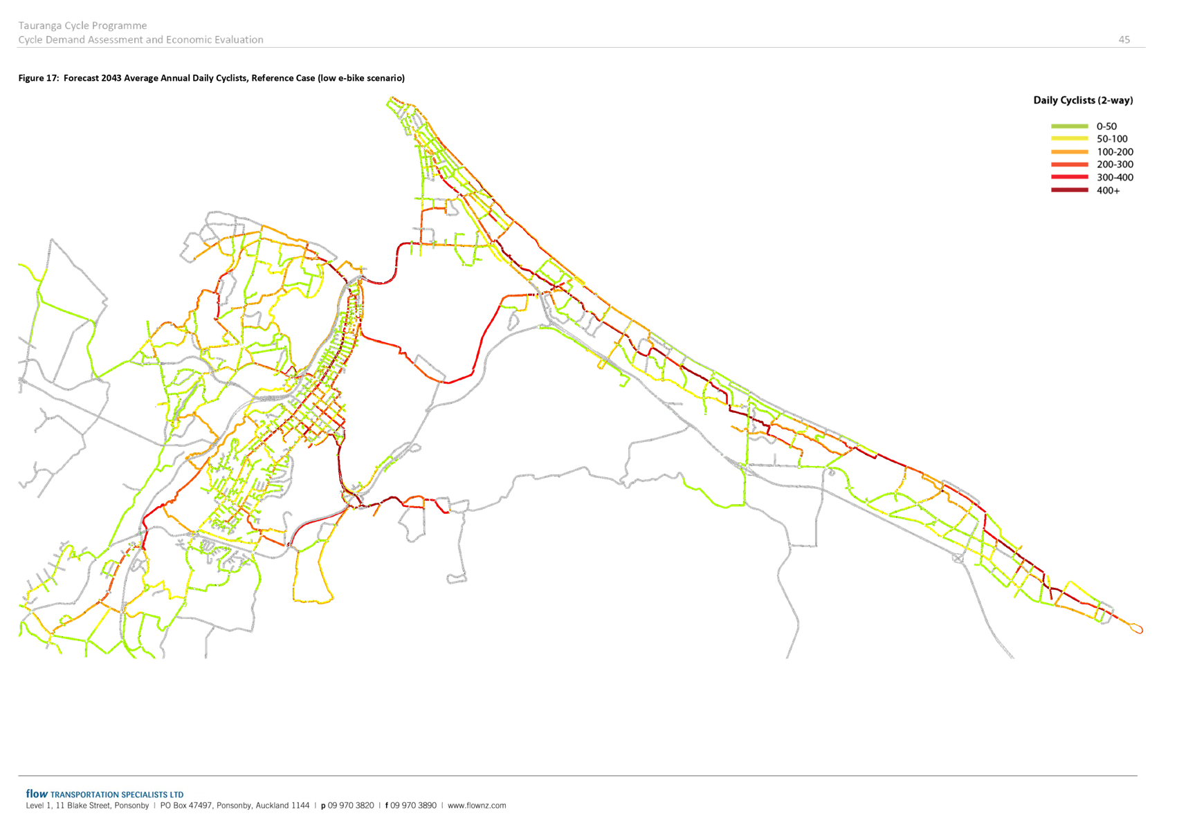
Multi-Modal Transport Programme 10 Year Investment Plans 
Te Papa Indictive Business Case
Benefits
1. This
attachment provides and overview of the potential benefits associated with the
Te Papa IBC preferred way forward as it relates to urban form and transport
interventions.
2. The
IBC assessment recognises Te Papa peninsula as a central element within the
wider urban system of Tauranga City and the Western Bay of Plenty, with ability
to release over $1billion in present value benefits to the community. In this
regard, and taking into account wider investment that will be required in
infrastructure and community amenities, the indicative benefit cost ratio (BCR)
associated with the recommended urban form and multi-modal transport programme
is estimated to be between 1.5:1 and 2:1.
3. The
recommended urban form and transport interventions will contribute to the
growth of the area and wider city in the coming 30 years. Growth projections
that form part of the Business Case include potential for up to 29,300
additional residents, 19,400 additional homes, and a 15,000 (60%) increase in
employees throughout the peninsula.
4. At
a high level, when compared to a ‘do minimum’ approach, the
recommended urban form and transport interventions have potential for
significant increases in the overall investment value with Te Papa (and
associated development benefits to get there), GDP contribution, and increase
in salaries and wages:
|
Do
minimum growth scenario
|
Preferred
Way Forward
|
|
Te
Papa Total Dwellings
|
+2,400
|
+19,400
|
|
Resident
Population
|
+3,600
|
+29,300
|
|
Employees
|
+9,500
|
+14,900
|
|
Te
Papa Estimated Dwelling Value
|
+$1.5b
|
+$11.6b
|
|
GDP
contribution
|
+$90m
p.a.
|
+$730m
p.a.
|
|
Salaries
and wages
|
+$400m
p.a.
|
+$630m
p.a.
|
5. The
urban form and multi-modal transport programme recommended will result in a
range of benefits for the city and Te Papa, including:
(a) Better
and more equitable access to social and economic opportunities
(b) Housing
that meets our needs
(c) More
opportunities for meaningful employment and economic growth in Te Papa
(d) Neighbourhoods
that are more liveable and have a stronger sense of culture and identity
(e) Improvements
in environmental quality.
These benefits are described in
more detail hereafter.
Better
and more equitable access to social and economic opportunities
6. Benefits
associated with ‘better and more equitable access to social and economic
opportunities’ include:
(a) Enabling greater choice,
quality, convenience and perceptions of choice has potential to increase active
modes and micro-mobility usage by more than double within 10 years and over
three times in 30 years.
(b) Public
transport usage by Te Papa residents can increase by over three times in 10
years and 10 times over 30 years. The network provided has an even more
significant role to play in the wider region for people to access jobs,
education, recreation, community and health services.
(c) Higher
levels of service relative to lower investment options.
(d) More
inclusive access for all users.
(e) Economic
benefits associated with more efficient transport infrastructure, including
trip reliability, trip time cost savings, operating savings and crash savings.
(f) Improved
perceived and actual safety for all transport users and the wider public.
(g) Improved
community health through increases of persons using active travel modes
(walking, cycling, micro-mobility and accessing public transport), with up $77m
of avoided health costs with a projected doubling of active mode travel choice
(based on $4,500 per person per lifetime health cost savings for intensified
urban areas)
(h) Transport
system multi-modal benefits (walking, cycling, micro-mobility and public
transport) assessed at greater than $350m over 30 years.
Housing
that meets our needs
7. Benefits
associated with ‘housing that meets our needs’ include:
(a) Potential
for up to 19,400 additional homes, providing increased housing availability and
choice including both mix of tenures and varied price points.
(b) Potential
to assist in improving relative housing affordability within wider region.
(c) Property
value increases averaging more than $150,000 per property, while simultaneously
seeing increases in wider housing stock availability that benefits lower income
households.
(d) Avoided GDP loss of $450m over
10 years due to housing issues
(e) Efficient
use of infrastructure through intensification, and associated savings to
Council and the community. Based on comparable cities (which have shown much
higher figures), these efficiencies potentially run at more than $25m for each
1000 households accommodated when compared with greenfields development. For
the projected 15,000+ additional households in Te Papa peninsula this equates
to a public sector investment efficiency gain of circa $375m.
(f) Integrated
urban form decision-making creating synergistic benefits: strongly aligned and
co-ordinated investment between government entities produces timing and
procurement efficiencies, and gives greater investment direction and certainty to
the private sector.
More
opportunities for meaningful employment and economic growth in Te Papa
8. Benefits
associated with ‘more opportunities for meaningful employment and
economic growth in Te Papa’ include:
(a) Employment
/ creation of jobs including, in in the short term, through construction,
including:
(i) Delivery
of new and upgraded housing, commercial, social and recreational infrastructure
as well as the transport and 3-waters infrastructure
(ii) Delivery
of new employment growth, catering to the local and regional markets.
(b) The
Te Papa peninsula will accommodate a significant proportion of the projected
employment growth for Tauranga in strong, well-performing local centres and the
city centre. These business locations are efficiently accessed across the
transport system, which will result in increased and sustained economic
productivity and prosperity.
(c) Significant
increases in agglomeration economies; strengthening of Te Papa business centre
occupancy, vibrancy and employment opportunities, with a focus on Tauranga city
centre’s $1.7b per annum GDP.
(d) Increased
attractiveness of Te Papa peninsula as an employment location through enhanced
urban form and multi-modal transport choices can accelerate job creation and
lift average wages through agglomeration effects.
(e) Wage
earning growth driven by density equating to over $12m to $23m+per 5 years for
each 10% density increase Productivity gains of $140m in 10 years, $650m 30
years.
(f) Significant
contribution to GDP associated with development and increases in local
employment, wages and salaries.
(g) Increasing
urban population by 10% raises wages by 0.2 to 0.5%.
(h) Doubling
urban density, on average, increases productivity by 2% to 6%.
(i) 10%
increase in ‘walking Effective Job Density’ (EJD) associated with a
>5% increase in productivity.
Neighbourhoods that are more liveable and have a
stronger sense of culture and identity
9. Benefits
associated with ‘neighbourhoods that are more liveable and have a
stronger sense of culture and identity’ include:
(a) Improved
environment and health outcomes, and positive impacts on sense of place and
identity.
(b) Strengthened
ratings of Te Papa peninsula liveability through better integrated urban form
and multi-modal transport networks:
(i) Community
ratings of liveability, identity and acknowledgement and respect for culture
(Tauranga City Council – Annual Surveys)
(ii) Māori
and Pacific cultural needs are recognised: Partnership involvement to inform
and shape urban decision-making to support identity, and well-being factors.
(c) Strengthened
cultural design considerations into investment into the Te Papa peninsula and
wider urban fabric.
(d) Enabling
people to live, work, play and learn within their community through enabling self-containment
will provide for a sustainable community.
(e) Multi-modal
transport opportunities will enable people to access social opportunities more
easily.
Improvements
in environmental quality
10. Benefits
associated with ‘improvements in environmental quality’ include:
(a) Reduced
emissions to the environment through greater uptake of sustainable travel
modes; potential for emissions to lessen by >35% relative to status quo
urban form development; CO2 emission savings at circa $3m.
(b) More
sustainable urban form design responses.
(c) Future
developments in the Peninsula will assist in greening the peninsula, reducing
carbon emissions, using resources efficiently, protecting our cultural heritage
and contributing to eco-system health and bio-diversity.
(d) Improving
multi-modal transport options and enabling intensified development close to
existing social and economic infrastructure will reduce emissions from
transport compared to additional greenfield dispersed development beyond that
already planned.
Summary
of monetised benefits
11. The
monetised benefits arising from the urban form and transport interventions are
summarised as follows:
|
Economic factor
|
Value
|
Coverage / notes
|
|
Wider economic
benefits
|
$2.2billion over 30
years (includes significant avoided public expenditure avoided costs)
The above translates
to a NPV of approximately $1billion.
|
· Public
expenditure benefit of Te Papa peninsula efficiency in accommodating urban
growth
· Wage
uplift for each 10% density increase.
· Productivity
gains of 2% to 6% for each doubling of density
· Avoided
health costs for population transferring to active modes within Te Papa
($4500 per resident)
· GDP
strengthening on $1.7b p.a. Tauranga city centre with intensification
· Capital
value increases for HHd and business associated with ‘20 minute’
neighbourhood characteristics.
· Induced
/ improved access to housing for lower income houses with flow on benefits
to social outcomes
· Avoided
GDP losses due to housing constraints / mismatches
|
|
Active Modes
|
$77million over 30
years
|
· 160%
active modes and micro-mobility usage within 10 years
· 300%
(2500 additional Te Papa peninsula residents) in 30 years
· Supports
wider regional network functioning and usage
|
|
Public transport
benefits
|
Modelling confirmation
work for May 2020
|
· 300%
increase in 10 years
· More
than 10 times over 30 years
|
|
CO2
|
$3million
|
· To
be confirmed via modelling
|
|
Travel time costs
|
Modelling confirmation
work for May 2020
|
· Achievement
of mode shift within Te Papa peninsula results in maintained demand on road
network for car users. Network will face growth pressure from wider
Western Bay of Plenty development dynamics.
|
|
Trip reliability
|
Modelling confirmation
work for May 2020
|
· Achievement
of modal shift within Te Papa enables transport network to better service
wider Western Bay of Plenty access and travel needs
|
|
Vehicle operating
savings
|
$25
|
· Cumulative
modal shift benefits over 30 years of residents moving to walking and cycling
|
|
Crash savings
|
Modelling confirmation
work for May 2020
|
· To
be confirmed via modelling
|
|
NPV total
|
>$1 b
|
· Indicative
BCR 1.5 to 2
|
|
Ordinary Council Meeting Agenda
|
5 May 2020
|
Te Papa Indicative
Business Case – Indicative Project Costs
Last updated:
23 April 2020
Indicative Project Capital Costs
|
Project
|
Total Costs
|
2021-2030 Costs
|
2031-2050 Costs
|
Notes
|
|
Transport
|
($m)
|
($m)
|
($m)
|
|
|
Cameron Road Multi Modal
‘Stage 1’
|
40.00
|
40.00
|
0.00
|
current estimated design and
construct cost; includes walking, cycling and PT
|
|
Cameron Road Multi Modal
‘Stage 2’
|
60.00
|
60.00
|
0.00
|
current estimated design and
construct cost; includes walking, cycling and PT
|
|
Walking
|
92.00
|
19.00
|
73.00
|
excludes double up with
Cameron Road (value $18m)
|
|
Cycling
|
126.00
|
62.00
|
64.00
|
excludes double up with
Cameron Road (value $23.5m)
|
|
City Centre Transport Hub,
Hospital, Greerton
|
50.00
|
40.00
|
10.00
|
$30m city centre; $10m others
|
|
Turrent Rd / 15th Ave
|
NA
|
-
|
-
|
Regional / TSP project
($100m)
|
|
Other PT related Capex,
includes secondary and tertiary network improvements, signals, shelters, etc.
|
32.00
|
16.00
|
16.00
|
Regional Council estimate.
Assumption: apportioned 50/50
|
|
Total Transport
Costs
|
400.00
|
237.00
|
163.00
|
|
|
Community Amenities
|
|
|
|
|
|
Memorial Park Aquatic
Centre
|
90.00
|
90.00
|
0.00
|
Current upper estimate
|
|
Central Library
|
35.00
|
35.00
|
0.00
|
Current estimate
|
|
Museum
|
NA
|
|
|
Not included; potential for
more cost effective options; ($56m)
|
|
City Centre / waterfront /
streetscape improvements
|
36.00
|
36.00
|
TBC
|
Based on current project estimates;
further programme confirmation and costing required for post 2030 timeframes
|
|
Community amenities and opens
space – general
|
97.00
|
48.50
|
48.50
|
Includes BVL capital works,
existing community facility upgrades, community centres, LoS upgrades for
open space, greenway improvements, and other improvements to support
increased population. Supporting: Apportioned 50/50
|
|
Total Community Amenities
Costs
|
258.00
|
209.50
|
48.50
|
|
|
Three Waters
Infrastructure
|
|
|
|
|
|
Water supply
|
10.00
|
10.00
|
TBC
|
Based on 3-waters
investigations and current LTP funding; further studies due late 2020; notes
significant short-medium term capacity
|
|
Wastewater
|
10.00
|
10.00
|
TBC
|
Based on 3-waters
investigations and current LTP funding; further studies due late 2020; notes
significant short-medium term capacity
|
|
Stormwater alleviation
|
150.00
|
75.00
|
75.00
|
estimate to provide
stormwater mitigation and address overland flow paths
|
|
Estimated 3-waters
Costs
|
170.00
|
95.00
|
75.00
|
|
|
Marginal 3-waters cost to
support development (30%)
|
51.00
|
28.50
|
22.50
|
Estimate of costs
attributed to Te Papa development requirements (as opposed to renewals and
wider capacity needs)
|
|
Total Costs
|
|
|
|
|
|
Total Costs
|
709.00
|
475.50
|
234.00
|
|
Indicative Project Operational Costs
|
Project
|
Total Costs
|
2021-2030 Costs
|
2031-2050 Costs
|
Notes
|
|
Transport
|
($m)
|
($m)
|
($m)
|
|
|
PT Opex costs
|
52.00
|
21.00
|
31.00
|
Regional Council estimate.
Assumption: Apportioned 40/60
|
10.2 Annual
Plan Review Process
File
Number: A11427798
Author: Jeremy
Boase, Manager: Strategy and Corporate Planning
Authoriser: Christine
Jones, General Manager: Strategy & Growth
Purpose of the Report
1. To
provide Council with a summary of the proposed approach and framework for a
revised approach to the 2020/21 Annual Plan taking into account the
significantly altered financial scenarios that COVID-19 restrictions have
resulted in.
|
Recommendations
That the Council:
(a) Endorses
the approach proposed through this report to review the draft 2020/21 Annual
Plan.
(b) Requests
that staff report back on options for a revised draft 2020/21 Annual Plan
once the review is substantively progressed.
|
Executive Summary
2. This
report provides an overview of the approach and framework for delivering the
2020/21 Annual Plan in a manner which reflects the impacts of COVID-19 on
Council.
3. The paper outlines workstreams
which are underway to consider:
· Reducing
the level of capital expenditure
· Reducing
operating expenditure
· Arrangements
for external funding or off-balance sheet financing
4. While not covered in detail in this paper, there are two further
workstreams underway which will also inform the development of the final
2020/21 Annual Plan. These are:
· Non-funding
operational expenditure
· Amending
the acceptable planning target for the debt-to-revenue ratio.
5. These
workstreams will help inform the development of a prudent, sustainable and affordable
2020/21 Annual Plan and will also help inform ongoing engagement with partners
regarding the impact of COVID-19 on Council’s finances and service
capacity.
6. Information is also provided about different scenarios and issues
for the timing of, and potential further consultation on, the final Annual
Plan.
Background
7. A report was presented to
the 21 April 2020 Council meeting outlining the potential impacts of a
combination of COVID-19 and Council’s underlying financial position on
the 2020/21 Annual Plan. Please refer to that report for background that
is equally relevant to this report.
8. On
receiving that report, Council resolved to seek further direction from the
Executive on a response to those potential impacts.
9. This
report provides Council with an overview of the work the Executive are
progressing to deliver on the decision of Council.
Creating a new budget in an
uncertain world
10. The
report to the 21 April Council meeting indicated that next year’s revenue
could be anywhere from $40 million to $77 million less than currently budgeted
in the draft Annual Plan. These figures were based on initial high-level
modelling under two different scenarios, one with significant restrictions on
movement, gatherings and social distancing for the whole of 2020/21, and one
for six months of such restrictions followed by six months of lesser impact.
11. Such
impacts on projected revenues have two distinct (but related)
consequences. Firstly, because of Council’s debt-to-revenue ratio
constraints, reduced revenue means reduced debt capacity. This means that
Council has less opportunity to use debt-financing to either pay for capital
expenditure projects or, as some councils have publicly stated they intend to
do, to fund operating expenses. Secondly, in order to create a
‘balanced budget[3]’
reduced operating revenue means Council needs to reduce its operating expenses
to match.
The
‘levers’ available
12. In
looking to significantly revise the 2020/21 budget to meet the necessary
parameters, there are a number of options available. These options are
not mutually exclusive; it is likely that any optimal budget-setting process
will include elements of many of the options.
13. The
options available which the Executive are proceeding to focus on include, but
may not be limited to:
· Reducing the
level of capital expenditure
To reduce cash outflow and
therefore debt levels, and also to reduce consequent operating expenditure
(‘pure’ operating expenditure as well as debt servicing and
depreciation costs).
· Reducing
operating expenditure
To reduce cash outflow and, with
reduced revenue, any need to fund operations from debt.
· Arrangement
of external funding or off-balance sheet financing
This could be an injection of
funding for capital projects or for operating expenses or both and could ease
the debt burden or the balanced budget burden or both.
· Non-Funding
operational expenditure
This creates a short-term
exemption from funding expenditure such as depreciation. However, it also
reduces the cash available to balance against debt and therefore results in a
net increase of debt. Legal requirements of prudent financial management
would need to be considered.
· Amending the
acceptable planning target for the debt-to-revenue ratio
A movement from the current
target of 235% to the maximum allowable under debt covenants of 250% would
provide some limited ability to increase debt (whether related to more capital
projects, reduction of funded depreciation, or the need to fund operating
expenditure) for the same amount of projected revenue.
14. Combined
together the above constitutes a significant body of work. That body of
work has twin objectives.
15. Firstly,
there is the need to develop an Annual Plan for the 2020/21 year which
represents prudent financial management, is sustainable for Council and its
community, is affordable for Council and its community, and is based on the
best available information at the time it is adopted.
16. Secondly,
this body of work will provide a more complete suite of information to base
further engagement with partners on regarding the implications of COVID-19
disruption on Council’s finances and service capacity.
17. The
next sections of this report consider the first three of the
‘levers’ noted above.
lever 1 – Reducing the
level of capital expenditure
18. A
workstream is underway to complete an assessment of all capital projects to
understand their priority, delivery impact of not proceeding, and any exit
costs.
19. A
two-stage assessment process has been approved by the Executive.
20. The
first stage involves a high-level, multi-criteria analysis of all projects
considering items such as:
· Consenting
or other legal matters
· Health
and safety matters
· Implications
for the social, economic, environmental and cultural well-being of communities
· Reputational
implications
· Alignment
with Crown Infrastructure Partners’ objectives, i.e. short-term and
long-term impacts on the local economy
· Whether
there is a sub-regional, regional or national benefit or expectation
· Internal
capability/capacity effects
· Impact
on residential and/or business land supply
· Other
projects' dependencies.
21. The
second stage involves more detailed consideration of projects that are already
in the construction phase or are planned for business case development, design
or implementation in the 2020/21 year. The more detailed consideration
will involve considering:
· Planned spend in
the 2020/21 Annual Plan, spend to date, and projected future years’ spend
· The
funding/financial benefits of a mothball, slow-down, re-scope or cancellation
· Capital
cost trade-off with operational benefits
· The
consequences of mothball, slow-down, re-scope or cancellation on:
o Service levels
o Contractual
consequences
o Reputational
consequences
o Reactivation
resources and other market factors if financial circumstances change
· Whether
there are realistic alternative options.
22. While this work is being completed
staff are ensuring that any new contracts include non-penalty exit clauses
which enable Council to cease, defer or change the timing of capital related
work with minimal negative financial implications for Council.
Lever 2 – reducing
operating expenditure
23. The
plan to review operating expenditure involves the following broad steps:
· Agree on
‘revenue disruption scenarios’ to base service and financial
modelling on
· Identify the
services[4]
that Council must provide regardless of revenue disruption scenario
· Identify services
that are ‘recommended to continue’ and assess for savings that
don’t negatively impact service delivery.
· Identify a series
of criteria to assess what other services could or should be provided under
different revenue disruption scenarios
· Assess all
remaining services against that series of criteria
· Identify the
budgeted costs of services assessed under the previous step
· Ensure that a
similar process has been conducted by Council’s CCOs.
These steps are expanded upon
below.
Step 1.
Agree disruption scenarios
24. It
is planned to use the three disruption scenarios that were used for the initial
high-level modelling and referred to in the 21 April Council report.
These are:
· Base Line Scenario
1 – No or minimal disruption
o This scenario is effectively
the existing draft Annual Plan service levels
o It equates to a full capital
budget of approximately $200 million
o It is broadly consistent with
Bay Venues Limited’s ‘optimistic’ scenario
· Scenario 2 –
Six months of revenue disruption (similar to Alert Level 3 or Alert Level 2)
o Under the high-level
modelling, this scenario reduces income by approximately $40 million and
permits a capital expenditure budget of approximately $100 million to $110
million
o It is broadly consistent with
BVL’s ‘moderate’ scenario
· Scenario 3 –
Full year of revenue disruption (similar to Alert Level 3 or Alert Level 2)
o Under the high-level
modelling, this scenario reduces income by $70 million to $80 million and
permits a capital budget of less than $20 million
o It is broadly consistent with
BVL’s ‘conservative’ scenario.
25. The
scenarios provide points on a spectrum which are useful for planning
purposes. They will serve as a methodology to consider scale and extent
of change and associated implications from an expenditure point of view.
The supporting analysis which is completed will provide information to elected
members to enable decisions on levels of service to be made. (As noted in
paragraph 12, the likely outcome is that there will be a mix of the different
levers to achieve a prudent budget not just operational expenditure).
Step 2.
Identify ‘must do’ services
26. This
step involves identifying the essential services that will be provided in
2020/21 regardless of revenue disruption levels, and then identifying the
associated budgeted costs.
27. The
completion of this step will draw heavily on those services considered
‘essential’ during the past four weeks of Alert Level 4 lockdown
and on work done through the COVID Planning Team, the business continuity
programme, and at a wider level by the SOLGM / LGNZ / DIA-led Local
Government Covid19 Response Unit. It will also include consideration
of the legislative obligations of Council.
28. It
is recognised that the definition of ‘essential’ for planning
purposes for a full year (or six months) may be slightly different to that
considered essential for an initial four-week period.
29. Identification
of the associated budgeted costs for these activities will be undertaken by the
Finance team to produce a first-cut of figures for discussion purposes.
Step 3. Identify ‘recommended to continue’
services and assess
30. This
step is to identify services that are not ‘must do’ services but
are of a nature that they are considered by Executive as ‘recommended to
continue’.
31. These
services will be assessed to identify any practicable savings which could be
made temporarily or permanently, without negatively impacting service delivery
or outcomes in any substantive way.
Step 4.
Identify criteria to assess other services against
32. This
step involves the establishment of some simple criteria against which to judge
whether services should continue to be provided in whole or in part in
circumstances of Council’s limited financial capacity.
33. The
criteria below have been approved by the Executive. They may be modified
through the process as there may be learnings about additional or changed
criteria as the work is completed.
· Ability
to and impact of ‘mothballing’ the service (taking into account
complexity, risk, and reputation impact)
· How quickly could
the service be reactivated if financial circumstances change?
· How quickly could
the service be reactivated if disruption levels change?
· How difficult is
it to reacquire technical skills if current resourcing is disrupted?
· What is the direct
short-term impact on the community (or parts of the community) of reducing or
removing the service? (Consider 4 well-beings impact.)
· What is the
long-term impact on the community (or parts of the community) of reducing or
removing the service?
· What are the
impacts of reducing or removing the service on social, economic, environmental,
and cultural well-being of the community?
· What is
(ordinarily) the funding source for the activity and is that likely to continue
under the modelled disruption scenarios?
· If funded by an
element of user fees, how quickly would user fees ‘scale up’ if the
service was resumed?
Step 5.
Assess services against the criteria above
34. All
services, other than those identified as ‘must do’ or
‘essential’ under Step 2, or ‘recommended to continue’
under Step 3 will be assessed against the Step 4 criteria.
35. In
the first instance, this assessment will be a desk-top exercise based on
organisational knowledge and any easily available relevant documents. It
will therefore be a subjective review.
36. Based
on this work the Executive will create a list, in an outline priority order
based on the assessment against the criteria, of services where a more detailed
assessment will be conducted. The results of these more detailed reviews
will be presented to Council as potential proposals under the different revenue
disruption scenarios.
37. In
making the initial assessments, the following practical matters will be
considered and documented so that decision-makers understand the limitations of
this form of review:
· any ‘known
unknowns’ in the assessment of the service
· any identified
knowledge gaps of the assessors in making an assessment of a particular service
(flagging the possibility of ‘unknown unknowns’)
· the overall
‘confidence rating’ in the assessment using a simple high / medium
/ low scale.
38. The
Step 5 assessment will start with externally-focused services and then proceed
to support services. This is because the scale of (or need for) some
support services may be dependent on the extent to which external services are
planned for. An understanding of the external services is therefore
useful when assessing the internal services.
39. Therefore,
there may be a need for Council direction on options for the continuation of
some external services before the internal service assessments can be
completed.
Step 6.
Identify budgeted cost of services assessed above
40. This
Step will largely run in parallel with Step 5 because of the inter-dependent
nature of ‘service definition’ and ‘budget
identification’.
41. As
with the assessment of services, the initial identification of budgeted costs
and revenues will be largely a desk-top exercise undertaken by the Finance
team. There will be significant judgement involved, particularly in the
split of costs between different services provided by the same team.
42. Consideration
will be given to the costs of delivering the service partially and also
differently than that provided for in the current draft 2020/21 AP.
43. The
identification of budgeted costs will need to consider direct costs first and
principally. The identification and attribution of allocated overhead
costs is significantly more difficult and will be part of a second tier of
financial assessment (once any changes to internal services are modelled to
general satisfaction).
Step 7.
CCOs
44. Step
7 will operate in parallel with Steps 1 to 6 and is included here largely for
completeness. We are aware that Bay Venues Limited is undertaking
modelling under three scenarios that are consistent with those listed in Step 1
above.
45. Tourism
Bay of Plenty and the Tauranga Art Gallery Trust are undertaking similar
exercises.
Implementing
the operational expenditure review plan
46. Staff
have created a template to enable the process outlined above to be rolled out
across the services of Council. Pilot assessments are underway to check
the methodology is practical.
47. Once
the template has been confirmed through the pilot process staff will proceed to
implement across all services other than the ‘must do’ services
identified in Step 2.
lever 3 – arrangements for
external funding or OFF-BALANCE sheet financing
48. Alongside
the detailed reassessment of Council’s capital and operating expenditure,
there is significant effort being invested in progressing opportunities for
external funding injection and/or off balance-sheet financing.
49. The
work underway includes:
· Ministry of Housing
and Urban Development’s urban growth projects request submitted through
the SmartGrowth partnership (in excess of $3 billion for TCC related projects)
· Crown
Infrastructure Partners’ ‘shovel-ready’ projects application
approved by Council for over $1 billion
· Growth Councils
Consortium (TCC, Hamilton City and Queenstown District Council) engagement with
central government raising issues and seeking investment
· Discussions with
Treasury to identify areas for support including option of revenue under-write
· Exploring other
opportunities to work with partners to hold infrastructure debt off balance
sheet or attract external funding / financing.
impact on consultation and
adoption of the final 2020/21 annual plan
50. Consultation
on the draft Annual Plan commenced on Friday 3 April and closed on Sunday 3
May. Hearings and deliberations are scheduled to follow in late May and
early June, with adoption of the final Annual Plan scheduled for 30 June.
51. It
is likely that Council will need to re-consult on its draft annual plan before
final adoption. These reasons, at different levels of impact, include:
· The potential for
other revenue to be significantly different to what was consulted on
· The potential for
the capital programme to be significantly different to what was consulted on
· The potential for
an injection of funding and/or projects through central government processes
that was not envisaged in the draft
· The potential for
significant changes to levels of service (which may trigger the statutory need
for an LTP amendment process).
· The potential for
rates increases to be significantly different to what was consulted on.
52. Staff
have prepared three scenarios of process and timeframes for the final 2020/21
Annual Plan. The outcomes of all the workstreams outlined above will
directly impact on which of these pathways is most appropriate for Council to
follow. The scenarios are presented in Attachment A in a detailed table
with specified timeframes. (The timeframes are tight and are likely to
move out. They are provided to give an indication of the key steps and
times).
53. In
summary, the three scenarios are presented below.
54. Scenario
1 – Update current information
· Updating the
current annual plan costs and revenues
· Update the current
consultation document with new information
· A short two-week
consultation on the new information (pending formal legal opinion as to whether
this would suffice)
· Later hearings
(June) and deliberations (July)
· Adoption on 31
July 2020.
55. Scenario
2 – Revised annual plan
· Involves a
complete revision of the annual plan that is currently out for consultation and
then development of a new draft plan
· Reporting the new
draft plan to council
· Re-writing the
consultation document based on the new plan and information.
· Consultation would
run for one month as per S82 of LGA (pending formal legal opinion as to whether
a shorter period would suffice)
· Later hearings
(mid-July) and deliberations (late-July)
· Adoption
mid-August 2020.
Note: The time constraints for
this scenario are very tight due to the need for having to consult for one
month.
56. It
should be noted that for scenarios 1 and 2 above staff will likely prepare
three financial scenarios of rating levels and the associated level of capital
expenditure. While all three scenarios could be included in the
consultation document, under the legislation Council will need to select one to
act as its ‘proposal’ to the community.
57. Scenario
3 – Long-term plan amendment (“LTPA”)
· This would involve
a comprehensive review of the impacts of COVID-19 on the remaining seven years
of the current LTP. This is potentially a further 6-8 weeks’ work.
· All work would
then need to be audited by Audit NZ
· An LTPA
consultation document would need to be produced and audited
· Consultation would
run for one month as per S93A of LGA
· Then hearings and
deliberations.
· This scenario
would have an adoption date of 30 September 2020.
Impact
of timing of Annual Plan adoption on rates invoicing
58. Ordinarily
Council sets the rates at the same time as adopting the Annual Plan. This
then provides four to six weeks to undertake preparatory work before invoicing
ratepayers in early August.
59. An
adoption date of 31 July does not provide this lead-in time and therefore would
delay the rates invoicing.
60. Section
50 of the Local Government (Rating) Act allows for Council to invoice 25% of
the previous year’s rates if it has not been able to adopt the Annual
Plan and set the rates 14 days before the instalment is to be invoiced.
This allows Council to ensure some cashflow even if the Annual Plan is
delayed. Section 50 could be applied in the event of an Annual Plan
adoption in late July or in August, or an LTPA process culminating in a September
adoption.
Significance
61. The
matters considered in this report have a high degree of significance. The
decisions recommended in this report are process-related and are of lower
significance. Once the reviews contemplated by this report are completed
and Council has made decisions based on them it is highly likely that further
engagement with the community will ensue.
Next Steps
62. Staff
will undertake the reviews described above and continue work on the other
‘lever’ workstreams, and report back to Council in due course for
consideration and decision-making.
Attachments
1. Attachment
A - Annual Plan - Indicative work and timeframe scenarios - A11427858 ⇩
|
Ordinary Council
Meeting Agenda
|
5 May 2020
|
Scenario 1 – Update current information
|
Action/Meeting type
|
Dates/Times
|
|
Lead time by Finance
to prepare information
|
5 May - 15 May
1-2 weeks
|
|
Draft amended CD for
adoption
|
8 May – 15 May
1 Week
|
|
Council (adopt new draft
and CD)
|
19 May (need
resolution for CD amendments)
|
|
Consultation
|
22 May - 5 June
2 weeks
|
|
Prepare Hearings
report and times for speakers
|
8 - 12 June
1 week
|
|
Hearings
|
17 June - 19 June
|
|
Prepare Deliberations
report
|
22 June - 3 July
2 weeks
|
|
Deliberations
|
8 July to 10 July
|
|
Run financial
processes and prepare adoption report
|
13 July - 24 July
2 weeks
|
|
Adoption of final AP
|
31 July
|
Scenario 2 –
New revised annual plan
|
Action/Meeting type
|
Dates/Times
|
|
Lead time by Finance
to prepare information
|
5 May – 22 May
2.5 weeks
|
|
New issue and options
paper to council
|
5 May - 22 May
2.5 weeks
|
|
Council (adopt new
draft)
|
26 May
|
|
Draft new CD for
adoption
|
2 June
1 Week
|
|
Council (adopt final
draft and new CD)
|
9 June
|
|
Consultation
|
10 June - 10 July
4 weeks
|
|
Prepare Hearings
report and times for speakers
|
13 July - 14 July (can
also be started while consultation is on)
|
|
Hearings
|
15 July - 17 July
|
|
Prepare Deliberations
report
|
13 July - 16 July (can
also be started while consultation is on)
|
|
Deliberations
|
22 July - 24 July
|
|
Run financial
processes and prepare adoption report
|
27 July – 6
August (exceedingly tight, possibly unachievable)
|
|
Adoption of final AP
|
11 August
|
Scenario 3 –
Long-term plan amendment
|
Action/Meeting type
|
Dates/Times
|
|
Review of the
associated parts of LTP to see what needs to be updated/change
· Review forecasting assumptions
· Review activity planning
· Review Financial Strategy
· Review Infrastructure Strategy
· Review Revenue and Financing Policy and associated rating
policies
· Fees and Charges
· Financial Forecasts
|
25 May
4 weeks
|
|
Discussions with Audit
NZ
|
1 May
|
|
New issue and options
paper to council
|
26 May - 11 June
2 weeks
|
|
Council
|
16 June
|
|
Prepare new LTP
documentation for Audit
|
16 June - 10 July
4 weeks
|
|
Prepare consultation
document
|
29 June - 10 July
2 weeks
|
|
Audit of LTPA and CD
|
6 July - 17 July
(would depend on confirmation from Audit NZ)
1 week
|
|
Report LTPA and CD to
Council
|
21 July
|
|
Consultation
|
21 July - 21 August
|
|
Prepare Hearings
report and times for speakers
|
21 August – 25
August (can also be done while consultation is on)
|
|
Hearings
|
26 August - 28 August
|
|
Prepare Deliberations
report
|
28 August - 3
September (can also be done while consultation is on)
|
|
Deliberations
|
9 September - 11
September
|
|
Run financial
processes, prepare adoption report and updated LTP
|
14 September - 25
September
|
|
Final Audit
|
14 September - 25
September
|
|
Adopt LTPA
|
30 September
|
10.3 SmartGrowth
Leadership Group Agreement and Memorandum of Understanding
File
Number: A11394950
Author: Christine
Jones, General Manager: Strategy & Growth
Authoriser: Christine
Jones, General Manager: Strategy & Growth
Purpose of the Report
1. To seek Council approval
of the updated SmartGrowth Leadership Group Agreement and Terms of Reference.
|
Recommendations
That the Council:
(a) Approve the updated
SmartGrowth Leadership Group Agreement and associated Terms of Reference as per
Attachment 1.
(b) Authorise the Mayor to sign
the agreement.
(c) Approve in principle the
Memorandum of Understanding between the SmartGrowth partners and Central
Government, attached as Attachment 2 and authorise Mayor to make any minor
amendments if required by the Government and to sign the MOU once it has been
agreed by Central Government.
|
Executive Summary
2. This report seeks Council
approval of a SmartGrowth (SG) updated Joint Committee Agreement which allows
Central Government to join the existing SmartGrowth partnership. It also
provides the partners with a Memorandum of Understanding which sets out how
Central Government and the SmartGrowth partners will work together.
Background
3. Late last year, Central
Government indicated that they would like to establish an urban growth
partnership with SmartGrowth in order to deliver on the Government’s
Urban Growth Agenda and in particular the joint spatial plan component. The
joint spatial plan is not just having an agreed plan among the sub-regional
partners, but also joining with the Crown, so that the plan is agreed and
signed off by Central Government in addition to local partnership adoption.
4. It
was decided that the best way for this partnership to occur was for Central
Government to join the existing SmartGrowth Leadership Group and to also have
involvement at management and technical levels. This is a similar approach to
that in the Waikato which has occurred through the Future Proof partnership.
5. Cementing
this partnership is occurring through two key documents:
· An
update to the SmartGrowth Leadership Group Joint Committee Agreement which
allows the Crown to join the Committee
· The
preparation of a Memorandum of Understanding between all of the parties
6. The Local Government Act
2002 (LGA) mandates the establishment of Joint Committees. The SmartGrowth
Leadership Group is a Joint Committee made up of representatives from Tauranga
City Council, Western Bay of Plenty District Council, Bay of Plenty Regional
Council, and tāngata whenua along with the New Zealand Transport Agency
and Bay of Plenty District Health Board in non-voting roles. The Committee has
been in place since 2004.
7. Clause 30A, 7th
Schedule of the LGA requires all Joint Committees to have an agreement across
the committee member organisations. This is particularly important for the
partner councils given that joint committees are established and operate in
accordance with the provisions of the Local Government Act 2002 although their
membership may extend beyond local government membership.
8. The current Agreement
states that it may be varied from time to time, but only with the agreement of
each of the partner councils.
9. There have also been
other changes since the existing SmartGrowth Leadership Group Agreement was adopted,
such as the Urban Form and Transport Initiative, new National Policy Statements
and the need to develop a joint spatial plan between the Crown and SmartGrowth.
The Agreement has been updated to reflect these changes.
10. The draft Agreement has been
approved subject to some amendments, by the SmartGrowth Leadership Group at its
meeting of 18 March 2020 and recommended to the partner Councils for
consideration and sign-off. It is also intended to be signed off by the Cabinet
as a suite of urban growth partnership initiatives in either June or July 2020.
The exact timing of this is to be clarified given the Covid 19 issue. Advice is
being sought from officials on this matter. It is proposed that notwithstanding
this timing uncertainty, that the Agreement is progressed. Officials support
this approach.
11. At this stage, it is intended that
the agreement would come into effect on 1 July 2020.
12. While a briefing of Ministers (5) in
Wellington was cancelled due to Covid 19 and the lockdown, and a visit by
Minister Twyford on 21 April is also postponed, engagement with Minister
Twyford by Chairs and Mayors occurred remotely during April.
13. Minister Twyford indicated last year
that he would like a Memorandum of Understanding (MOU) between Government and
the SmartGrowth partners. At the December SmartGrowth Leadership Group meeting
the Independent Chair was delegated authority to progress this MOU. The
Chair presented on the MOU to the February SLG meeting and at its March
meeting, the SmartGrowth Leadership Group approved in principle the MOU and
recommended that partner Councils approve it in principle given that there may
be requests from the Crown for amendments. The Independent Chair was delegated
authority to make any minor adjustments if requested by the Crown.
14. The MOU covers the relationship and
how the parties work together. It is separate to the Agreement which is a
formal document for establishing joint committees and mandated by the Local
Government Act 2002.
THE AGREEMENT
15. As considered and adopted by the
SmartGrowth Leadership Group at its 18 March meeting, an amended Joint
Committee Agreement has been prepared and is attached to this report as Attachment
1.
16. The existing agreement (adopted in
2017) has been amended as follows:
· Expanded
membership to include Central Government (up to three Ministers of the Crown
with voting capacity)
· References
to also implementing the outcomes from the Urban Form and Transport Initiative
and the joint spatial plan, in addition to the SmartGrowth Strategy.
· Three
local government members instead of four (noting Councils had only appointed 3
members each post the October 2019 elections)
· Changes
to the delegations, the main one being the addition of the Urban Growth
Partnership and delegations associated with progressing and implementing that
work, in particular the joint spatial plan
· Removal
of the delegations out of the Terms of Reference as these are already covered
in the main part of the Agreement and replacing these with the principles and
outcomes from the Memorandum of Understanding between SmartGrowth and the
Crown.
· The
addition of monitoring and review to the Terms of Reference.
· No
provision for alternates for the voting members of the SmartGrowth Leadership
Group.
· Changing
the meeting frequency from bimonthly to quarterly or as and when necessary.
17. The New Zealand Transport Agency and
the Bay of Plenty District Health Board have membership rights but in a
non-voting capacity. This is the same situation that has existed over the last
three years.
18. The local authorities made their
appointments late last year after the October elections and appointed 3 elected
member per council. Unless a council wishes to change its representation, there
is no need to re-nominate representatives as the number remains the same.
19. However, tangata whenua will need to
nominate their representatives as this has not yet occurred.
the memorandum of understanding
20. The MOU is attached as Attachment
2. It establishes the principles and approach to the creation of an
enduring spatial plan partnership between Central Government and the
SmartGrowth partners. The MOU covers general principles, outcomes and
next steps.
Next Steps
21. Each of the partner Councils will be
asked to pass parallel resolutions to those in this report. Discussions
with occur with Central Government to enable the MOU to be finalised.
Attachments
1. Attachment 1 : SLG -
Urban Growth Partnership Agreement and TOR 30032020 - A11396039 ⇩
2. Attachment 2 :
SG-Central Govt Partnership MOU 30032020 - A11394938 ⇩
|
Ordinary Council
Meeting Agenda
|
5 May 2020
|

Attachment 1
SmartGrowth Leadership Group (Joint Committee) Agreement
1. Purpose
This
Agreement is made pursuant to Clause 30A, Schedule 7 of the Local Government
Act 2002 (“LGA 2002”). The purpose is to provide for a Joint
Committee of Tauranga City Council, Western Bay of Plenty District Council, the Bay of Plenty Regional
Council, and tāngata whenua[5] to undertake and implement strategic spatial
planning across the western Bay of Plenty sub-region[6] in accordance with
the SmartGrowth Strategy, outcomes from the Urban Form and Transport Initiative
and the joint spatial plan as agreed between the Crown and the SmartGrowth
partners. This joint committee is known as the ‘SmartGrowth Leadership
Group’.
The
Leadership Group has additional public body representation from the New Zealand
Transport Agency (NZTA) through its Director of Regional Relationships and the
Bay of Plenty District Health Board (DHB). The NZTA and DHB are non-voting
members but have speaking rights.
The
SmartGrowth Leadership Group has expanded membership for the Urban Growth
Management Partnership and associated programmes to include Central Government.
This
Agreement focuses on the Leadership Group, including its membership and
delegations. Any additional Memoranda of Understanding that are completed will
be in addition, and complementary to, this Agreement.
The joint SmartGrowth Leadership Group
has been established to focus on strategic spatial planning, including the four
well-beings (social, economic, environmental, cultural), and growth management
in the western Bay of Plenty sub-region. This will occur through developing and
implementing plans and strategies and recommending these to the SmartGrowth
partners, as well as monitoring and undertaking reviews in accordance with the
delegations set out in section 4 and the principles set out in the Terms of
Reference attached to this Agreement as Appendix 1.
The Leadership Group is a formal joint committee pursuant
to the Local Government Act 2002 (Clause 30 and 30A, Schedule 7). The
Leadership Group will not be discharged at the point of the next election
period (in line with Clause 30(7) of Schedule
7, LGA 2002).
2. Membership
The SmartGrowth Leadership Group is to
be comprised of three elected member representatives as appointed by the local
authorities, including the Mayors and Regional Council Chairperson, and four
tāngata whenua representatives to be nominated by Iwi or through any other
agreed mechanism. The SmartGrowth Leadership Group may at its discretion,
appoint an additional tāngata whenua representative.
In
addition, up to three Ministers of the Crown who will have voting capacity, are
to be appointed by the Crown. Additional Ministers, if
and when relevant and required, can be appointed by the SmartGrowth Leadership
Group in a non-voting capacity.
An Independent Chairperson
(non-elected member) is to be appointed by the SmartGrowth Leadership Group to
chair the Committee. The Independent Chairperson has speaking rights and voting
capacity. A Deputy Chairperson is also to be appointed by the SmartGrowth
Leadership Group at the beginning of each triennium, from the existing voting
membership.
The NZTA is to be represented through
its Director of Regional Relationships with speaking rights but in a non-voting
capacity. The DHB is also represented on the Leadership Group, by a person to
be nominated by the Board with speaking rights but in a non-voting capacity.
The standing membership of the
Leadership Group shall be limited to 17 members (including the Independent
Chairperson), but with the power to co-opt up to a maximum of three additional
non-voting members where required to ensure effective planning and implementation.
In accordance with Clause 30A of Schedule 7 to the Local Government Act 2002,
the quorum at a meeting of the Leadership Group shall be 9 voting members.
Other representatives of voting and non-voting organisations are permitted to attend meetings
of the Leadership Group. Speaking
rights of other
representatives at Leadership Group meetings (whether in public session
or not) shall only be granted with the prior approval of the
Chairperson. In respect of SmartGrowth Leadership Group workshops, all members
of partner governance groups can attend and participate.
3. Meeting Frequency
Quarterly,
or as necessary and determined by the Independent Chairperson.
Notification of meetings and the publication of agendas and reports shall be conducted in accordance with the
requirements of Part 7 of the Local Government Official Information and
Meetings Act 1987 and will be
undertaken by the agreed administration authority.
4. Delegations
The SmartGrowth Leadership Group is delegated
the following functions in support of its overall purpose:
Co-ordinating
Sub-regional Spatial Planning
§ Providing
sub-regional leadership on spatial planning, growth, infrastructure planning
and development, focusing on key issues including the four well-beings[7]
and the sustainable management of natural resources.
§ Undertaking
high-level spatial planning and dealing with cross boundary matters.
§ Determining
as far as practicable consistency between the various Government National
Policy Statements
§ Overseeing
and coordinating National Policy Statement on Urban Development implementation.
§ Reviewing
and updating the SmartGrowth Settlement Pattern
§ Overseeing
infrastructure / facilities and the funding necessary to implement the
Settlement Pattern.
§ Setting
overarching sub-regional policy, actions and approaches relevant to the
SmartGrowth Strategy.
§ Sharing
the challenges of implementation and overcoming the barriers moving forward.
Urban
Growth Partnership
§ Overseeing
the development and implementation of a joint spatial plan for the western Bay
of Plenty sub-region and associated work streams, including adopting any drafts
for public consultation.
§ Overseeing,
including any reviews and monitoring, a joint urban growth programme.
§ Ensuring
organisation systems and resources support implementation of the joint spatial
plan and any associated urban growth programme.
§ Addressing
cross-boundary matters within the western Bay of Plenty sub-region, as well as
with other neighbouring regions.
§ Addressing
housing affordability matters.
§ Monitoring
the implementation of the spatial plan and associated work streams.
§ Reviewing
and recommending changes to the spatial plan if circumstances change.
§ Ensuring
alignment with existing council plans, strategies and policies, and with
existing evidence.
§ Ensuring
alignment with initiatives already underway such as the Urban Form and
Transport Initiative.
§ Facilitating
consultation with the partners and the wider community where relevant.
Future
Thinking and Advocacy
§ Having
a united voice where issues require joint advocacy.
§ Development
and leadership of an agreed sub-regional advocacy programme
§ Engagement
on intra and inter-regional matters where there are impacts beyond the
sub-region, including matters of Upper North Island or national importance.
§ Facilitating
community understanding and discussions/conversations.
§ Facilitating
specific consultation with the community on SmartGrowth implementation matters.
§ Establishing,
maintaining and engaging with the SmartGrowth Partner Forums.
§ Communicating
and engaging with key stakeholders where a sub-regional level view is required.
§ Identifying
and resolving any consultation inconsistencies between the SmartGrowth
strategies and subsequent public consultation processes of the partner Councils
SmartGrowth
Strategy Development, Implementation and Alignment Monitoring
§ Overseeing
the implementation of the 2013 SmartGrowth Strategy, in particular the strategy actions, and undertaking any reviews or
updates to the Strategy, including adopting any drafts for public consultation.
§ Ensuring
organisation systems and resources support strategy implementation.
§ Taking
responsibility for progressing those actions specifically allocated to the
SmartGrowth Leadership Group in the strategy and making sure implementation
does occur.
§ Reviewing
and recommending adjustments to the strategy if circumstances change.
§ Champion
integration and implementation through partner strategies, programmes, plans
and policy instruments (including the Regional Policy Statement, Regional and
District Plans, Long Term Plans (LTPs), Annual Plans, transport plans and
triennial agreements) and through partnerships with other sectors such as
health, education and business.
§ Approving
submissions to Local Authorities, Central Government and other agencies on SmartGrowth
related matters
§ Monitoring
of the strategic outcomes and ensuring a joined-up approach to strategy
implementation, including monitoring and reporting implementation progress
against key milestones
§ Overviewing
the management of the risks identified in implementation.
§ Making
specific recommendations to partners on the joined-up thinking needed for
resolving issues
Committee
Operations
§ Selecting
and appointing an Independent Chairperson and a Deputy Chairperson.
§ Implementing
any Memoranda of Agreement or Understanding, as adopted by the Leadership
Group.
§ Establish
protocols and arrangements to ensure that implementation, where necessary, is
consistent, collaborative and/or coordinated to achieve optimal outcomes.
Central Government’s
participation in the SmartGrowth Leadership Group does not constitute
endorsement of initiatives in any way, and all financial, policy and other
decisions still need to be approved by Central Government.
5. Variation
of this Agreement
This agreement may be varied from time
to time, but only with the agreement of each of the partners.
Execution
Bay
of Plenty Regional Council by:
|
Chairperson: Doug Leeder
|
Chief Executive: Fiona McTavish
|
|
Dated:
Tauranga
City Council by:
|
Dated:
|
|
Mayor:
Tenby Powell
|
Chief
Executive: Marty Grenfell
|
|
Dated:
|
Dated:
|
|
Western
Bay of Plenty District Council by:
|
|
Mayor:
Garry Webber
|
Chief
Executive: Miriam Taris
|
|
Dated:
|
Dated:
|
Tāngata
Whenua Representative by:
Buddy
Mikaere
Dated:
Central
Government
by:
Dated
Appendix 1:
SmartGrowth Leadership Group Terms of Reference
SmartGrowth
Leadership Group (SLG)
|
Purpose:
|
The purpose of the Joint
Committee (SmartGrowth Leadership Group) is to undertake and implement
strategic spatial planning across the western Bay of Plenty sub-region[8]
in accordance with the SmartGrowth Strategy, outcomes from the Urban Form and
Transport Initiative and the joint spatial plan as agreed between the Crown
and the SmartGrowth partners.
The SmartGrowth
Leadership Group carries out its purpose in accordance with the delegations
set out in the Agreement.
|
|
General
Principles:
|
The
SmartGrowth Leadership Group operates under the following principles:
§ Supporting
the aim of developing a thriving western Bay of Plenty sub-region that is
prosperous, has high levels of sustainable economic growth, supports
affordable housing along with a transport system that can support that
growth.
§ Supporting
a four well-being approach to urban growth and spatial planning which
incorporates cultural, economic, environmental and social well-being and
builds on the SmartGrowth ‘live, learn, work and play’ vision.
§ Reinforcing
an integrated planning approach incorporating land use, all infrastructure
and funding.
§ Building
on existing SmartGrowth work, including the 2013 Strategy, outcomes from
Urban Form and Transport Initiative (“UFTI”), and the general
SmartGrowth arrangements already in place.
§ Adopting
a shared evidence base so that all parties are using common data.
§ Recognising
and supporting the existing Urban Form and Transport Initiative
(“UFTI”) which will underpin the development of one joint
sub-regional spatial plan.
§ Taking account of the Western Bay
Transport System Plan findings.
§ Acknowledging
the benefits of a collaborative approach to urban growth and spatial
planning, and to share responsibility for such planning between the parties
in consultation with key sector groups and the sub-regional community.
§ Supporting
the economic and social aspirations of tāngata whenua while protecting
cultural identity.
§ Sustaining
and improving the natural environment.
|
|
Monitoring
and Review:
|
The
SmartGrowth Leadership Group has responsibility for:
§ Six-
monthly monitoring and reporting on implementation of the principles set out
in this Terms of Reference.
§ Monitoring
the implementation of any joint urban growth programme developed.
§ Monitoring
and reporting SmartGrowth implementation progress against key milestones.
§ Reviewing
and recommending any changes to the SmartGrowth Strategy if circumstances
change.
|
|
Membership:
|
That
representation of the SmartGrowth Leadership Group be comprised of:
§ Three
elected member representatives as appointed by the contributing authorities,
including the Mayors and Regional Council Chairperson - voting
§ Four
representatives to be nominated by tāngata whenua - voting
§ An
Independent Chairperson, to be appointed by the Leadership Group, to chair
the Group – voting
§ Up
to three Ministers of the Crown – voting
§ Additional
Ministers, if and when relevant and required – non-voting
§ One
DHB representative – non-voting
§ One
NZTA representative – non-voting
That the standing membership of the Leadership Group
shall be limited to 17 members (including the Independent Chairperson), but
the SmartGrowth Leadership Group has the power to
co-opt up to a maximum of three additional non-voting members where required
to ensure the effective implementation of any part or parts of the Strategy
including the joint (Crown and local partners) spatial plan.
|
|
Meeting
Frequency:
|
Quarterly, or as
necessary and determined by the Independent Chairperson.
|
|
Ordinary Council Meeting Agenda
|
5 May 2020
|
Attachment
2
SmartGrowth and Central Government Spatial Plan
Partnership - Memorandum of Understanding
Establishing
the principles and approach to the creation of an enduring spatial plan
partnership between Central Government and the SmartGrowth partners (Bay of
Plenty Regional Council, Tauranga City Council, Western Bay of Plenty District
Council and tāngata whenua)
Section 1 -
Purpose
The purpose of
this Memorandum of Understanding (“MOU”) is to:
Establish the
principles and approach to the creation of an enduring spatial plan partnership
between Central Government and the SmartGrowth partners (Bay of Plenty Regional
Council, Tauranga City Council, Western Bay of Plenty District Council and tāngata
whenua[9]).
Section 2 -
Parties
The Parties to
this MOU are Central Government, western Bay of Plenty sub-region tāngata
whenua, the Bay of Plenty Regional Council, Tauranga City Council and Western
Bay of Plenty District Council.
Section 3 -
General Principles
The parties to
this MOU will use best endeavours to:
SUPPORT the
aim of the spatial plan partnership to develop a thriving western Bay of Plenty
sub-region that is prosperous, has high levels of sustainable economic growth,
supports affordable housing and a transport system that can support that
growth.
SUPPORT a four
well-being approach to urban growth and spatial planning which incorporates
cultural, economic, environmental and social well-being and builds on the
SmartGrowth ‘live, learn, work and play’ vision.
COMMIT to the
shared purpose and outcomes as outlined in this MOU while assisting each other
to achieve individual partner objectives.
REINFORCE an
integrated planning approach incorporating land use, all infrastructure and
funding.
AGREE to build
on the existing SmartGrowth work, including the 2013 Strategy, outcomes from
Urban Form and Transport Initiative, and the general SmartGrowth arrangements
already in place.[10]
ADOPT a shared
evidence base so that all parties are using common data.
RECOGNISE AND
SUPPORT the existing Urban Form and Transport Initiative (“UFTI”)
which will underpin the development of a joint sub-regional spatial plan.
ACKNOWLEDGE
the benefits of a collaborative approach to urban growth and spatial planning,
and to share responsibility for such planning between the parties in
consultation with key sector groups and the sub-regional community.
AGREE to six-
monthly reporting to the SmartGrowth Leadership Group on implementation of the
principles and achievement of the outcomes as set out in this MOU.
ACKNOWLEDGE
that this partnership is part of a wider Government Urban Growth Agenda
initiative.
SUPPORT the
economic and social aspirations of tāngata whenua while protecting
cultural identity.
SUSTAIN and
IMPROVE the natural environment.
Section 4
– Outcomes
The outcomes
sought from the urban growth partnership are to:
§ Commit to the development and
implementation of a joint, comprehensive sub-regional spatial plan. The first
phase to be completed by June 2020 concentrates on an integration of the
current UFTI and spatial planning work. Phase 2, that is likely to be
completed by the end of 2020 will also encompass the Future Development
Strategy as well as an update of the 2013 SmartGrowth Strategy. The aim is to
develop in two phases a single strategic document for the western Bay of Plenty
sub-region, which is implemented through co-governance arrangements. Engagement
and consultation will occur as part of this process. It is likely that formal
consultation will take place at the end of Phase 2.
§ Commit to the development and
implementation of an agreed investment and funding plan that is co-governed
across all partner agencies, to enable timely implementation of the outcomes
arising from the Urban Form and Transport Initiative, and the agreed joint
spatial plan as outlined above.
§ Take account of the Western
Bay Transport System Plan findings.
§ Commit to examining the opportunities
for the development of an inter-regional collaboration between the SmartGrowth
and Future Proof partnerships, with the strategic intent to have a joint
Auckland-Hamilton-Tauranga corridor approach to spatial planning, particularly
relating to transportation.
§ Invest in all infrastructure,
together, through innovative funding and financing tools.
§ Work together on improving the quality
of the built and natural environments.
§ Ensure that tāngata whenua are
adequately resourced to effectively engage in the partnership and the key
outcomes.
§ Advance planning reform, through
legislation and local planning instruments, to encourage growth both up and
out.
§ Commit, where possible, to supporting
the development aspirations of Maori landowners for housing and other economic
initiatives.
§ Undertake joined up central and local
government thinking, funding and commitments, including greater co-ordination
of service delivery.
§ Maintain a focus to ensure that
housing affordability remains top of mind through all initiatives.
§ Commit to funding the operation of the
enhanced SmartGrowth partnership.
Section 5
– Next Steps
The parties to
this MOU will use best endeavours to implement the spatial planning partnership
by:
SUPPORTING an
expansion of the SmartGrowth Leadership Group to include Central Government
representatives.
COMMITTING to
a review of tāngata whenua representation to ensure this is appropriate
and comprehensive and will allow for meaningful contribution.
NOMINATING
representatives to participate in SmartGrowth structures at all levels.
ALLOCATTING
sufficient resources to enable the partnership to deliver the outcomes.
COMMITTING to
completing a draft of the joint spatial plan no later than June 2020.
COMMITTING to
agreeing a draft joint transformational urban growth – spatial planning
programme no later than June 2020.
COMMITTING to
investigating the establishment of an urban growth partnership fund where
applications can be made for funding transformational projects on an annual
basis.
Section 6 -
Interpretation
§ SmartGrowth partners refers to the Bay
of Plenty Regional Council, Tauranga
City Council, the Western Bay of
Plenty District Council and tāngata whenua. It also includes the New
Zealand Transport Agency and the Bay of Plenty District Health Board as
non-voting partners. This membership is subject to review from time to time.
§ Central Government refers to all
Government ministries and agencies.
§ Joint spatial plan refers to a plan
that is agreed by central government, local government partners and
tāngata whenua and implementation partners
§ SmartGrowth means the western Bay of
Plenty Spatial Plan 2013 as approved by the three
partner Councils and tāngata
whenua and supported by strategic partners.
§ The SmartGrowth Leadership Group is
the joint governance committee responsible for overseeing the SmartGrowth
Strategy.
§ The western Bay of Plenty sub-region
refers to all of the land within the administrative areas of Tauranga City and
the Western Bay of Plenty District and includes that part of the administrative
area of the Bay of Plenty Regional Council as it relates to the two districts.
Any questions
of interpretation of this MOU are to be raised with the parties to this MOU and
collectively resolved. The parties agree to act in good faith in respect of
implementing this MOU.
This MOU will
run until the next review or update of the SmartGrowth Strategy, or
alternatively no later than October 2022.
This MOU takes
effect on the date it is signed by all parties.
|
SIGNED for
and on behalf of Central Government by:
|
SIGNED for
and on behalf of Central Government by:
|
|
SIGNED for
and on behalf of the Tāngata Whenua by:
Buddy Mikaere
|
SIGNED for
and on behalf of the Bay of Plenty Regional Council by:
Doug Leeder
Chair Bay of
Plenty Regional Council
|
|
SIGNED for
and on behalf of the Tauranga City Council:
Tenby Powell
Mayor
Tauranga City Council
|
SIGNED for
and on behalf of the Western Bay of Plenty District Council:
Garry Webber
Mayor Western
Bay of Plenty District Council
|
Dated:
10.4 Western
Corridor Wastewater Study
File
Number: A11391329
Author: Claudia
Hellberg, Team Leader: Waters Strategy & Planning
Authoriser: Christine
Jones, General Manager: Strategy & Growth
Purpose of the Report
1. To inform councillors of progress in relation to the
Western Corridor Wastewater Study and seek approval to proceed with steps to
advance its implementation.
|
Recommendations
That the Council:
a) Endorse
the outcomes of the Western Corridor Wastewater study.
b) Agree to immediately proceed with
preliminary design and planning in the 2019/20 financial year funded by a
reallocation of other available wastewater planning budgets.
c) Agree
in principle the completion of design and urgent delivery of construction for
the interim stage subject to funding being available through 2020/21 Annual
Plan or other processes as approved by Council.
d) Note
that costs associated with future stage 1 and 2 will be considered through
development of the 2021-31 LTP and associated 30-year infrastructure
strategy.
e) Approves
exemption from open competition and direct appointment of the recommended
contractor (as outlined in confidential Attachment 4) for the Western
Corridor Wastewater preliminary and detailed design.
f) Retains
Attachment 4 (A11407716) in confidential on the
grounds that withholding of the information is necessary to enable Council to
carry on, without prejudice or disadvantage, negotiations (including
commercial and industrial negotiations). The attachment and
recommendation can be publicly released when negotiations and contract are
finalised.
|
Executive Summary
2. The Tauranga area has experienced significant growth in
recent years, with a forecast population of nearly 200,000 people by 2063. As
part of a continued commitment to planning and managing infrastructure to
facilitate growth, TCC in conjunction with its SmartGrowth Partners, are both
considering the development of the Western Corridor (broader Tauriko/Pyes Pa
area).
3. The Western Corridor area was identified by SmartGrowth and
provides an opportunity for development of an additional 15,500 dwellings and
approximately 120ha of industrial land over the next 50 years. The areas
considered include residential land within the growth areas of Tauriko West,
Lower Belk Road, Upper Belk Road, Keenan Road, Merrick Road and Joyce Road. The
industrial land (Lower Belk) is located adjacent to the Tauriko Business
Estate, currently nearing completion.
4. GHD were engaged by TCC to develop the Western Corridor
Wastewater Implementation Strategy. The strategic servicing strategy considered
the requirements to be able to service not only the short-term developments,
but also longer-term areas identified for future growth. The servicing strategy
divided infrastructure into a number of stages – Interim, Stage 1 and
Stage 2. Interim servicing allows for the connection to the
existing network to support some (but not all) short term development areas.
Stage 1 identifies infrastructure required for the full build out of short-term
development and Stage 2 for longer-term development.
5. Interim stage servicing requires a rapid delivery of the
Tauriko pump station and rising main from the pump station to Kennedy road and
the storage at existing Kennedy Road pump station to enable development of the
zoned Tauriko Business Estate area to be completed. The intention is to carry
out the design in a phased approach:
· Preliminary Design – to confirm the sizing and
detailed arrangements for the required infrastructure as well as site
investigation and consenting works; and
· Detailed Design to facilitate the delivery of the required
infrastructure.
Background
6. This
report is a first one in a series of reports in regard to water infrastructure
projects to provide councillors with information about these significant
projects prior to the upcoming LTP discussions.
7. The Tauranga area has experienced significant growth in
recent years, with a forecast population of nearly 200,000 people by 2063. As
part of a continued commitment to planning and managing infrastructure to
facilitate growth, TCC in conjunction with its SmartGrowth Partners, are both
considering the development of the Western Corridor (broader Tauriko/Pyes Pa
area).
8. The Western Corridor includes areas of recent development
within Tauranga (such as the Lakes and Tauriko Business Estate) as well as
future growth areas identified as potentially occurring within the next 5-50
years. The Western Corridor area is located to the south west of Tauranga
City and extends into the Western Bay of Plenty. The Western Corridor
area was identified by SmartGrowth and provides an opportunity for development
of an additional 15,500 dwellings and approximately 120ha of industrial land over
the next 50 years. The areas considered include residential land within
the growth areas of Tauriko West, Lower Belk Road, Upper Belk Road, Keenan
Road, Merrick Road and Joyce Road. The industrial land (Lower Belk) is located
adjacent to the Tauriko Business Estate, currently nearing completion.
9. One of the key drivers for this project is that growth in
the area has been occurring faster than previously anticipated including
completion of The Lakes residential development approximately 10 years ahead of
the developers schedule and the pre-sale of approximately 50ha of industrial
sections in the final zoned stage of Tauriko Business Estate. TCC see the
Western Corridor Wastewater Implementation Strategy providing the opportunity
for a co-ordinated approach to servicing the overall area for the next 50 years
i.e. a blueprint to support more efficient delivery of wastewater
infrastructure in response to development pressures.
10. Although the bulk of the new development areas identified
in the Western Corridor currently lie within the Western Bay of Plenty
district, wastewater infrastructure to service these areas is expected to pass
into Tauranga City and through areas where growth is likely to happen within
the next 5 years. TCC therefore require a wastewater implementation strategy to
be developed that: considers stakeholder and council objectives and forecast
growth; identifies core wastewater infrastructure requirements, and provides an
adaptive, flexible and staged approach to delivery.
11. GHD were engaged by TCC to develop the Western Corridor
Wastewater Implementation Strategy. The implementation strategy will be used to
support on-going discussions with developers, iwi and other stakeholders.
Strategic / Statutory Context
12. Urban
development cannot proceed without adequate servicing of wastewater. It is
Council’s responsibility to ensure that new developments are
appropriately serviced before titles for individual lots are
issued.
Options Analysis
13. The strategic servicing strategy considered the
requirements to be able to service not only the short-term developments, but
also longer-term areas identified for future growth. The strategy considered
existing infrastructure, constraints mapping, resilience and sustainability in
order to develop the routing of the truck infrastructure. It also considered a
range of routing arrangements which were considered using a range of Multi
Criteria Assessment (MCA) to determine the preferred option(s) and staging of
the works.
14. Due to the development pressure in the area, the servicing
strategy considered an interim stage where a portion of immediate development
could connect to the existing network at Kennedy Drive Pump Station (PS), as
long as sufficient operational storage can be provided for the new and existing
network to manage peak wet weather flows. This interim servicing would be
used until the Stage 1 infrastructure could be constructed to allow the full
development area to be connected.
15. There is an area within Tauriko Business Estate (TBE)
proposed for immediate development (referred to as TBE 3A) that was
planned to be serviced via extension of the existing wastewater network as per
the Tauriko Business Estate structure plan. Due to localised topography
issues, undeveloped properties along the proposed route and pipe sizing within
existing parts of the network, servicing of this area in accordance with the
structure plan solution is very challenging and no longer feasible. It is
instead considered that area 3A of TBE be included in the proposed interim and
longer-term servicing strategy for the broader Western Corridor. Benefits of
the change in servicing strategy for the TBE 3A area is a simplified network,
which will be easier and cheaper to operate in the long run however it requires
additional upfront investment costs (see below).
16. The servicing strategy divides infrastructure into a number
of stages – Interim, Stage 1 and Stage 2 (Attachment 1 to 3).
Interim servicing allows for the connection to the existing network to support
some (but not all) short term development (TBE Stage 3A and part of Tauriko
West and the proposed TBE extension south of Belk Road). Stage 1 identified
infrastructure required for the full build out of short-term development (Lower
Belk, Tauriko West, Keenan Road North). Stage 2 identified infrastructure
required for longer-term development options if they proceed (Upper Belk,
Keenan Road South, Merrick Road and Joyce Road).
17. The forecast growth requires the wastewater infrastructure
to be built and upgraded over a relatively short period, in three proposed
stages: Interim, Stage 1 and Stage 2. At this stage, the Interim solution is
the most critical as it will service TBE Stage 3A as an immediate priority, as
well as provide potential capacity for Tauriko West and the proposed Lower Belk
industrial area. Preliminary Design, including site investigations and further
engagement, is required to advance this work further with the aim of being able
to carry out detailed design by the end of 2020 subject of funding being
available. Funding for this infrastructure is included in TCC
applications to the Government economic stimulus programmes via CIP and the
Urban Growth workstreams.
18. The
route design is at a conceptual stage; therefore the current cost estimate of
the proposed solution is high level and is based on the current outline design
information along with TCC standard designs where relevant for the pump
stations. The baseline cost estimate was derived from first principles and is
based on the information provided by GHD and some supplier pricing. It
should be noted that updated and detailed costing will need to be prepared as
the design process moves into preliminary and detailed design.
19. Design, investigations, consenting and delivery of the
Interim stage is estimated to cost in the range of $25M. Delivery of all stages
of the infrastructure is estimated to cost nearly $110M. GHD costings do not
include cost of land acquisition, or contaminated land investigation. The
prices have a base date of 2019.
20. Interim stage servicing requires a rapid delivery of the
Tauriko PS and rising main from the PS to Kennedy road and the storage at
existing Kennedy Road PS. The intention is to carry out the design in a phased
approach:
· Preliminary Design – to confirm the sizing and
detailed arrangements for the required infrastructure as well as site
investigation and consenting works; and
· Detailed Design to facilitate the delivery of the required
infrastructure.
21. In
order to meet required timelines required by TBE in relation to pre-sold
sections to be serviced as part of this wastewater solution, it is required to
continue with preliminary design immediately. Preliminary design, site
investigations, and detailed design would be required by late 2020.
22. Construction may be delivered in different packages,
potentially with TCC taking the lead for infrastructure outside of Tauriko
Business Estate and the developers of Tauriko Business Estate delivering the
infrastructure within their growth area in conjunction with their own civil
works programme.
23. The project is subject to funding availability via the
2020/21 Annual Plan, upcoming LTP and government stimulus processes. TBE
may look to deliver all the infrastructure on their land in order to ensure
that their blocks can be serviced. Completion of the Preliminary Design will
ensure that the long-term growth requirements are considered. Capex
budgets are included in the draft 2020/21 Annual Plan for costs expected to be
incurred in the next financial year.
Financial Considerations
24. Currently there is minimal budget
allocated in the LTP beyond the next financial year for the extension of the
western wastewater network, as growth has occurred much faster in this area
than anticipated and previous structure plan solutions are no longer feasible.
As mentioned above, the wastewater network extension as proposed has been
included in TCC’s funding application as part of central government
growth stimulus processes.
25. The
draft Annual Plan 2020/21, which was considered and signed off by council in
March 2020 included budget for the interim stage of this wastewater solution
following discussion and debate about the matter by council. Since then
the Covid-19 situation has evolved and there is significant uncertainty around
TCC’s financial ability to deliver its capex programme –
particularly in the upcoming financial year.
26. It
should be noted that the interim stage of the Western Corridor wastewater
project is included in TCC applications to government financial stimulus
processes.
27. Approval
is sought from Council to reallocate available wastewater 2019/20 budget to
this project to enable planning to commence immediately. The contract for
these services will be written in a manner which enables the work to be placed
on hold should the 20/21 Annual Plan budget for provide for this project to
proceed.
Legal
Implications / Risks
28. In
order to meet desired deadlines for the implementation of the interim solution,
it is recommended to deviate from council general procurement policy. As the
total value of the supply arrangement will be beyond the $200K, council
approval will be required (as set out in the confidential attachment).
Consultation / Engagement
29. Consultation and engagement on the
whole wastewater solution with iwi/hapu and key stakeholders, including
developers is planned to be carried out in parallel to the preliminary design
for the interim solution.
Significance
30. The community has been engaged on the
Western Growth Corridor through various processes including the development of
the proposed Future Development Strategy and through the Tauriko for Tomorrow
project. The wastewater servicing strategy provides for important and
significant wastewater infrastructure required to be implemented to enable this
growth.
Next Steps
31. Seek approval from council to
proceed with the urgent delivery of design for the interim stage of the Western
Corridor wastewater solution.
32. Carry
out Preliminary Design, including any required site investigations and early
engagement with stakeholders, followed by detailed design with the aim of being
able to finalise design (including detailed design) by late 2020 subject to
funding being available.
Attachments
1. Concept Interim Stage -
A11412987 ⇩
2. Concept Stage 1 -
A11412991 ⇩
3. Concept Stage 2 -
A11413042 ⇩
4. Confidential Attachment
to report Western Corridor Wastewater Study - A11407716 - Public Excluded
|
Ordinary Council
Meeting Agenda
|
5 May 2020
|

|
Ordinary Council
Meeting Agenda
|
5 May 2020
|

|
Ordinary Council
Meeting Agenda
|
5 May 2020
|

10.5 Walking
and Cycling Business Case
File
Number: A11405719
Author: Karen
Hay, Team Leader: Cycle Plan Implementation
Authoriser: Nic
Johansson, General Manager: Infrastructure
Purpose of the Report
1. To
seek approval to submit the Walking and Cycling Business Case to the Waka Kotahi
NZ Transport Agency for approval in June 2020
|
Recommendations
That the Council:
(a) Endorses
the recommended “Cycling Connections and Area Accessibility” as
the preferred programme option, subject to funding availability.
(b) Approves
that the Walking and Cycling Business Case be submitted to New Zealand
Transport Agency, as part of the UFTI programme business case, for
consideration and approval in June 2020.
(c) Notes
investment timeframes, costs and cost sharing arrangements with project
partners will come before Council for approvals as the programme progresses.
|
Executive Summary
2. This
walking and cycling business case (Accessible Streets) is intended to be
submitted to Waka Kotahi as part of the Urban Form and Transports Initiative
(UFTI) programme business case that supports multi modal outcomes for Tauranga.
This business case and UFTI are interlinked and combined support an enhanced
multi-modal transport system for Tauranga.
3. The
focus of this report is on the Accessible Streets Business Case, including:
(a) An
overview of the options considered
(b) The
recommended ‘preferred way forward’ for urban form and the
supporting multi-modal transport programme
(c) A
summary of the recommended programme, including indicative timing
(d) A
summary of potential benefits accruing from the recommended programme.
4. As
outlined on the NZ Treasury’s website, programmes business cases (PBC)
are about managing change with a strategic vision and a roadmap of how to get
there. They comprise several activities that will be completed in
tranches over an extended period to achieve outcomes that are greater than the
sum of the parts.
5. The
PBC is used as the basis for seeking early approval to start a preferred
programme of work, to develop subsequent business cases and to review the
ongoing viability of the programme. It provides an early opportunity for
the organisation and key stakeholders to influence the direction of the
investment proposal and to avoid too much effort being put into developing
investment proposals and options that should not proceed.
6. The
business case recognises that this cycling programme is one component of a
wider suite of initiatives being developed by Tauranga City Council, in
partnership with other agencies, to improve personal mobility, accessibility
and travel choice in Tauranga. As such, the connection
to the wider suite of initiatives such as UFTI and the Te Papa Spatial Plan is
critical.
7. Extensive
modelling has been undertaken to determine the contribution that a completed
cycle network can make to the Tauranga Transport network. The potential is for:
(a) Travel
to work mode shares increasing to between 6.5% and 10% in 2043, from 3.5% today
(b) Travel
to school mode shares increasing to between 14% and 15% in 2043, from 8.5%
today
(c) Between
2,600 and 3,200 fewer commuter peak car journeys each day
8. Consideration
was given to the impact that e-bikes could have on cycle mode share. The
results are as follows:
(a) The
preferred programme is predicted to increase the total number of daily cycle
trips from the current 11,000 daily trips, to between 27,000 and 33,000 trips
by 2043, an increase of between 140% and 190%.
(b) Larger
increases are predicted in terms of the total cycle-km travelled on the
network, at between 180% and 250%. This indicates that the programme is
predicted to result in not only more cycle trips within Tauranga, but longer
cycle trips.
9. The
benefits for the city and community include:
(a) Cycling
is widely accepted as a safe and attractive alternative transport choice in
both existing and newly developed urban areas
(b) Improved
health, environmental, social, and place outcomes
(c) Improved
access to opportunities, particularly for people with low levels of transport
choice
(d) Support
liveability and placemaking outcomes
(e) Increased
safety for people using bikes.
10. Whilst
this programme is focussed on cycling in the first instance, it is expected
that secondary benefits will accrue to other modes that can also utilise
cycling connections and routes – such as walking and small wheeled
electric devices e.g. mobility and electric scooters. Safety benefits are also
derived when cycling infrastructure is in place that assists with reducing
speeds and enhances access for people walking.
Background
11. Over
the last 30 years Tauranga City has doubled in size and is now New
Zealand’s fifth largest city. With growth forecast to continue in
the future, the city and wider Western Bay of Plenty sub-region have undertaken
an Urban Form and Transport Initiative programme business case to identify how
best to manage growth in terms of where people live and how they can move.
12. As
Tauranga City grows, access to economic and social opportunities via the
transport system is becoming increasingly challenging, particularly at peak
times. Private motor vehicle use dominates in Tauranga, and there are few
viable alternatives for how people can move throughout the City. Compared
to other New Zealand cities, Tauranga has:
(a) one
of the highest percentage of people who use a private motor vehicle to travel
to work (91%)
(b) the
lowest percentage of people who travel to work via public transport (2%), or
walk to work (4%)
(c) one
of the lowest percentages of people who cycle to work (3%).
13. Equally,
the evidence shows that some of the challenges to getting more people biking
are.
(a) Perceptions
of cycling safety risks in Tauranga is a disincentive to the uptake of people
who want to bike more or try biking
(b) Much
of our previous transport investment has historically focused on increasing
roading capacity and less on other transport modes, which has contributed to a
high private vehicle usage when travelling to work and education facilities
(c) The
lack of protection for cyclists contributes to cycling related death and
serious injury (DSIs) crashes
14. Cycling
network options (i.e. programme options) were developed using the Tauranga
Cycle Model (TCM), which is based upon the same methodology used to develop
cycling models for Christchurch and Auckland. The model was used to
identify broad areas where there is high potential demand for cycle trips,
namely for the purposes of accessing employment or education hubs, and how
these areas might connect if appropriate cycle infrastructure was to be
provided.
15. The
model also considered changes in land use: the model is informed by forecast
land use changes (via links to Council’s current forecast strategic
traffic model and the Tauranga Transport Strategic Model). This means that
forecast increases in population, employment or education result in increased
future cycle trips within the model
Council decisions on the Cycle
Programme
16. As
part of the Councils deliberations on the Long Term Plan on the 28th of May
2018 (DC218 Long Term Plan 2018-28
Deliberations - Tauranga Cycle Plan Recommendations and Appendices- (DC166),
the Council mandated progression of the Cycle Plan as outlined in the table
below:
Error! Not a
valid link.
17. The
Council endorsement noted the necessity of increased central government subsidy
to enable Council to deliver multi-modal options in the city in a reasonable
timeframe
18. Given
the Councils current financial constraints impacted by COVID 19, any funding
and progression of the programme will be subject to annual plan and the LTP
deliberations.
Strategic / Statutory Context
19. More
recently, the Transport Agency’s National Mode Shift Strategy (Keep
Cities Moving) has identified Tauranga City as one of the six critical
locations in NZ to grow the share of public transport, walking and cycling, and
create more vibrant and liveable cities. The Strategy recognises that
Tauranga’s current population size, together with the pace and scale of
forecast growth, creates both an urgency and an opportunity for change.
20. The recommended programme aligns with
the strategic priorities (Access, Safety and Environmental Sustainability) as
identified in Governments Policy Statements .
Connection with UFTI
21. The work completed in this walking
and cycling business case has meant that the UFTI programme has not had to
consider walking and cycling network options. This is to avoid duplication
between the projects. To provide a complete multi-modal transport system
programme, UFTI will need to incorporate the preferred walking and cycling
network option. Without this connection, UFTI will have a significant gap in
its programme.
22. Waka
Kotahi will not consider a single mode business case, hence the need for this
programme to be endorsed and be submitted as part of the UFTI programme
business case.
Options Analysis
23. Five
high-level cycle programme options were developed to connect key origins and
destinations relating to employment and education hubs. The options build on
from previous cycling work developed in the last triennium. The options are
based on different networks and the quality of those networks, rather than
identifying different routes and corridors.
24. The
TCM was then used to assess the effectiveness of network options in
facilitating mode share change, and to refine the network options (as
required). This methodology is consistent with the approach taken to
develop the Auckland and Christchurch cycling programmes, both of which have
been endorsed by the NZ Transport Agency.
25. The
Cycling network options assessed for Tauranga are:
|
Cycling network options
|
Summary
|
|
1.
Business as Usual /Do minimum
|
No
significant changes made to extending the existing Tauranga cycle network.
New greenfield development and the urbanisation of existing rural roads
within development areas will enable development of new on-road and off-road
cycling facilities. These improvements would be delivered by developers and
would increase the length of the current cycling network where cycling is
required (as per the Council’s Infrastructure Development Code).
|
|
2.
Painted Cycle Lanes
|
Developing
a cycle network based on painted cycle lanes. The network is based on
providing painted cycle lanes on existing arterial and collector roads. This
programme would enable an additional 108km[11] of on-road painted cycle
lanes. Most of the improvements are concentrated within Papamoa,
Bayfair and Otumoetai, where existing painted cycle lanes are not currently
present. This programme does not include any new off-road cycling
facilities.
|
|
3.
Neighbourhood access
|
This programme is focused
on developing a neighbourhood-based cycling networks to enable access schools
and other facilities. Traffic calming (speed limit reviews, speed humps)
would be introduced on all local streets and collectors throughout Tauranga,
to complement painted cycle lanes. There would be no new investment on
arterial corridors.
This option includes an
initial 230 km of traffic calming (as most local streets are not included in
the TCM). However, a wider rollout would be required to ensure
appropriate treatments were provided on all local roads.
|
|
4.
Cycling connections and area access
|
This programme is based
on developing a cycle network by connecting areas together, mainly where
employment and educational facilities are located. This programme includes:
· 50 km of high quality
off-road shared use walking and cycling paths
· 49km of on-road cycling
lanes within existing road corridors, generally of a good quality but with
regular intersections and vehicle crossings
· traffic calming on local
streets in selected areas
|
|
5. High quality connections
|
This network programme is
similar to Option 4 whereby the focus is enabling cycling access to key
employment and education hubs within Tauranga. The difference is that the
quality of the cycling paths would increase with a view of providing separation
between cyclists and other modes on all key cycle arterials.
This programme would
deliver approximately 100km of new and separated cycling paths and lanes to
provide greater access to key employment hubs within the city.
|
Options assessment
26. The
preparation of this business case built on work undertaken, including community
engagement results from the Cycle Plan. Additional evidence was provided
through modelling of options.
27. A
multi criteria analysis (MCA) was utilised to assess the potential of each of
the five options to contribute to the programme’s investment objectives,
and to assess economic and implementation considerations, based on the above.
The consultant team in conjunction with Council staff completed the MCA scoring.
28. Through
this process a recommended option was identified, which was then tested and
refined through further detailed analysis.
29. A
summary of the MCA is outlined below together with associated investment
objectives
|
Criteria
|
P1: Do min
|
P2:
Painted lanes
|
P3:
Neighbourhood
|
P4:
Cycling connections and area
|
P5: High Quality Cycle paths
|
|
Investment objectives
|
Increase
of peak mode share of walking and cycling in Tauranga from 3% to 8% by 2043
|
1
|
2
|
1
|
2
|
3
|
|
Double
active travel in Tauranga, from 200 annual km travelled by walking and
cycling per capita to 400 km by 2043
|
0
|
1
|
1
|
2
|
3
|
|
25%
reduction in annual walking and cycling DSIs in Tauranga by 2043, from the
existing 16 annual DSIs
|
-1
|
0
|
1
|
2
|
2
|
|
Implementation
considerations
|
Integration/conflict
with other transport modes
|
-2
|
1
|
1
|
2
|
2
|
|
Deliverability
|
3
|
1
|
2
|
0
|
-2
|
|
Stageability
|
-2
|
3
|
1
|
2
|
2
|
|
Financial feasibility
|
3
|
2
|
2
|
1
|
-1
|
|
Economic considerations
|
BCR range[12]
|
Not
calculated
|
0.7-0.9
|
0.7-0.8
|
1.5-1.8
|
1.0-1.1
|
|
Rank
|
5th
|
3rd
|
4th
|
1st
|
2nd
|
Note* An early benefit
cost ratio calculated from initial cycle modelling analysis was used to
identify the options to consider in more detail. The information presented in
the MCA summary is based on the information available when undertaking the MCA.
Further analysis and refinement of the associated benefits and costs has
subsequently been completed.
30. Based
on the MCA results, Option 4 (Cycling Connections and Area Accessibility) is
the most optimal. It scored highly against investment objectives relating
to the rate of participation in cycling (resulting in higher health and
decongestion benefits) and cycle safety.
31. It
is one of two options to provide an integrated cycle network across the City
and takes a balanced approach to infrastructure investment, realising benefits
through network optimisation and the development of new connections, delivering
better value for money as reflected in the BCR. Complexities associated
consenting and community engagement are considered manageable with appropriate
technical resources, and the option to stage delivery to realise incremental
benefits.
Financial Considerations
32. The
indicative benefit cost ratio (BCR) associated with the recommended programme
under the high e-bike scenario is estimated to be between 2.7 - 3.3. The 10-year
programme under the same scenario has an indicative BCR between 3.9 - 4.3. The
BCR is now subject to final peer review which we expect to verify the
identified benefits.
33. The
estimated cost of the total programme is $186.9M of which the 10-year programme
is $77.2M. The costs associated with Te Papa cycling infrastructure are
included within the Te Papa Business Case.
34. A
description of project benefits, including monetisation is included in Attachment
1.
Legal Implications / Risks
35. Risks
of not acting includes inconsistency with central government direction,
including emerging direction in the draft 2021 GPS.
36. The
risks of not acting also includes in the inability for Tauranga to manage the
rate that congestion will increase, and not supporting social, health and
wellbeing outcomes for Tauranga.
Significance
Having regard to Council’s Significance and Engagement
Policy, significance of this project is considered ‘high’. It
affects a wide range of people; has moderate to high public interest. Staff
continues the commitment to work with Mana Whenua, Stakeholders and local
communities as the implementation of the programme progresses.
Next
Steps
37. Subject
to Council’s approval of the Business case, the next steps in this
process are:
(a) The
Walking and Cycling business case is to be submitted to NZTA’s
Operational Policy, Planning and Performance Delegations Committee on 14 May
2020
(b) Subject
to the Operational Policy, Planning and Performance Delegations Committee
approval, the IBC is submitted to NZTA’s Investment and Operations
Committee (date to be confirmed)
(c) Subject
to the Investment and Operations Committee approval, the Walking and Cycling
business case is submitted to NZTA’s Board on 18 June 2020, alongside the
UFTI programme Business Case.
(d) Subject
all approvals, planning for standard interventions and
detailed business cases commences from August onwards.
Attachments
1. Tauranga Walking and
Cycling Economic Case April 2020 - A11431118 ⇩
2. Tauranga Cycle
Programme Technical Report - A11417910 ⇩
|
Ordinary Council
Meeting Agenda
|
5 May 2020
|


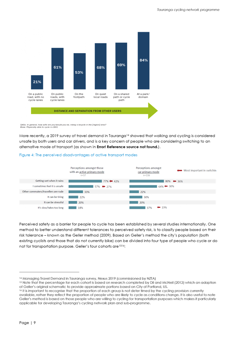


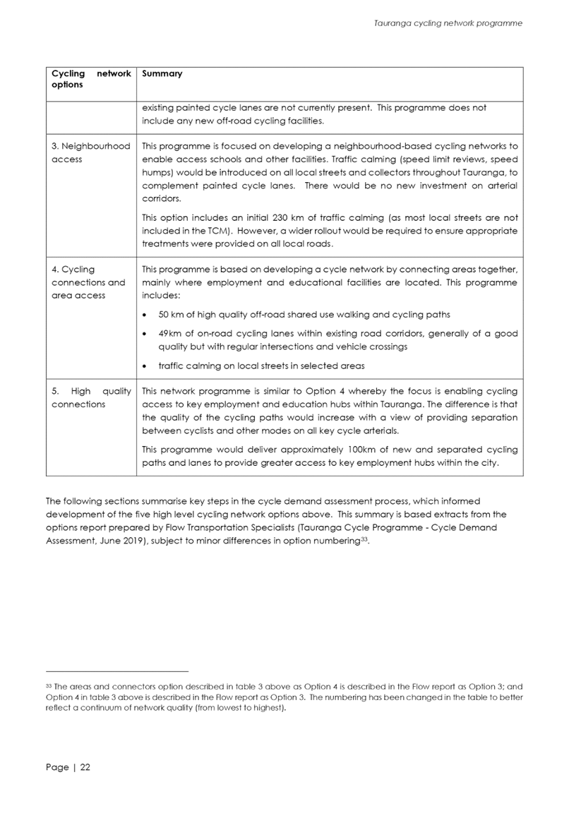


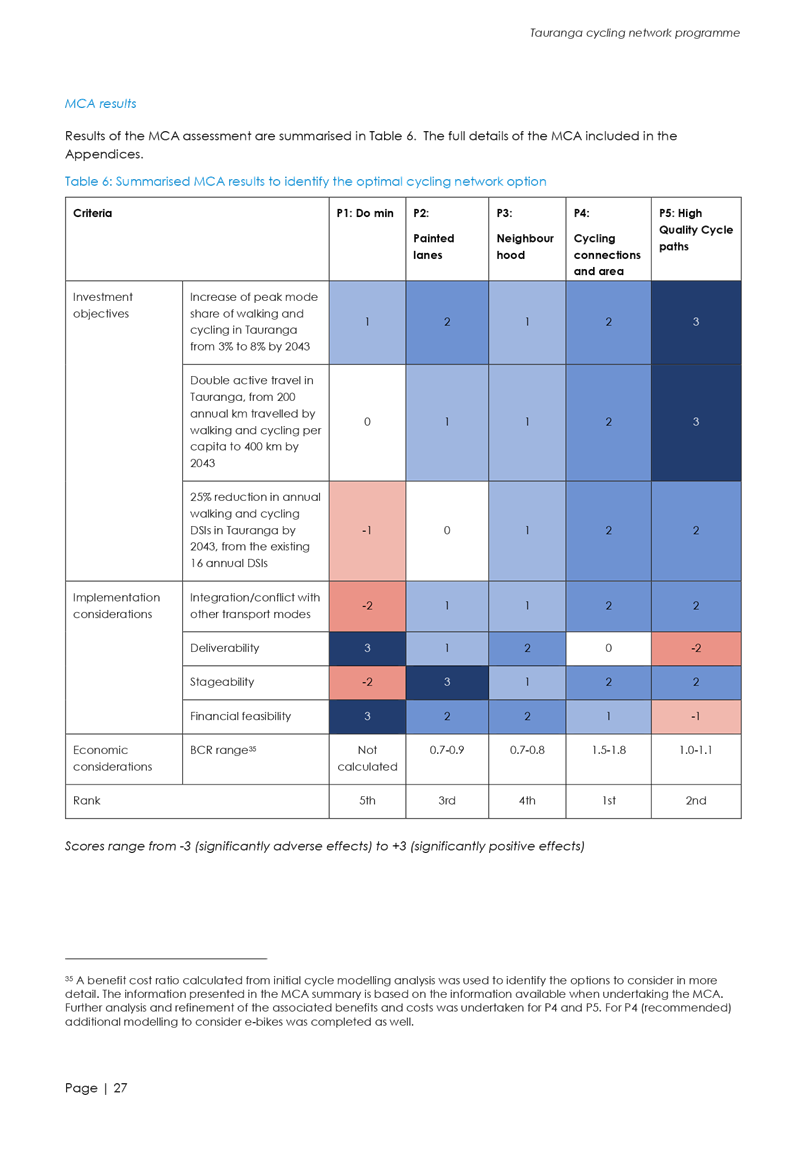
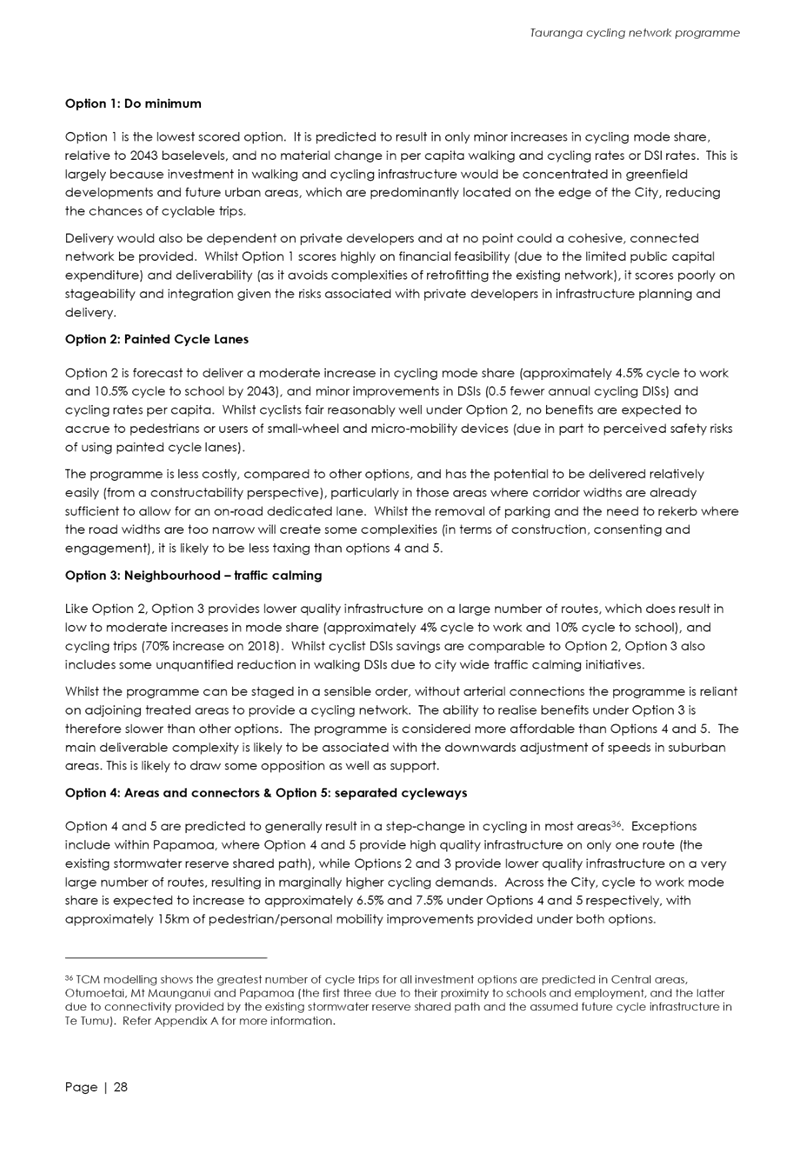


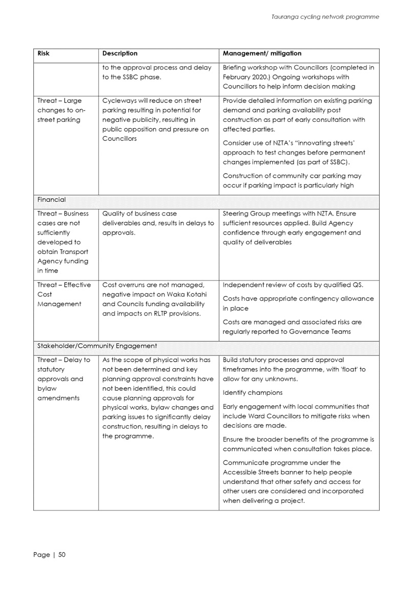


|
Ordinary Council Meeting Agenda
|
5 May 2020
|


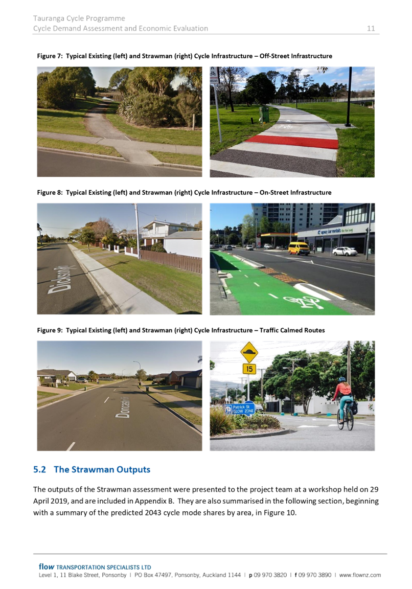
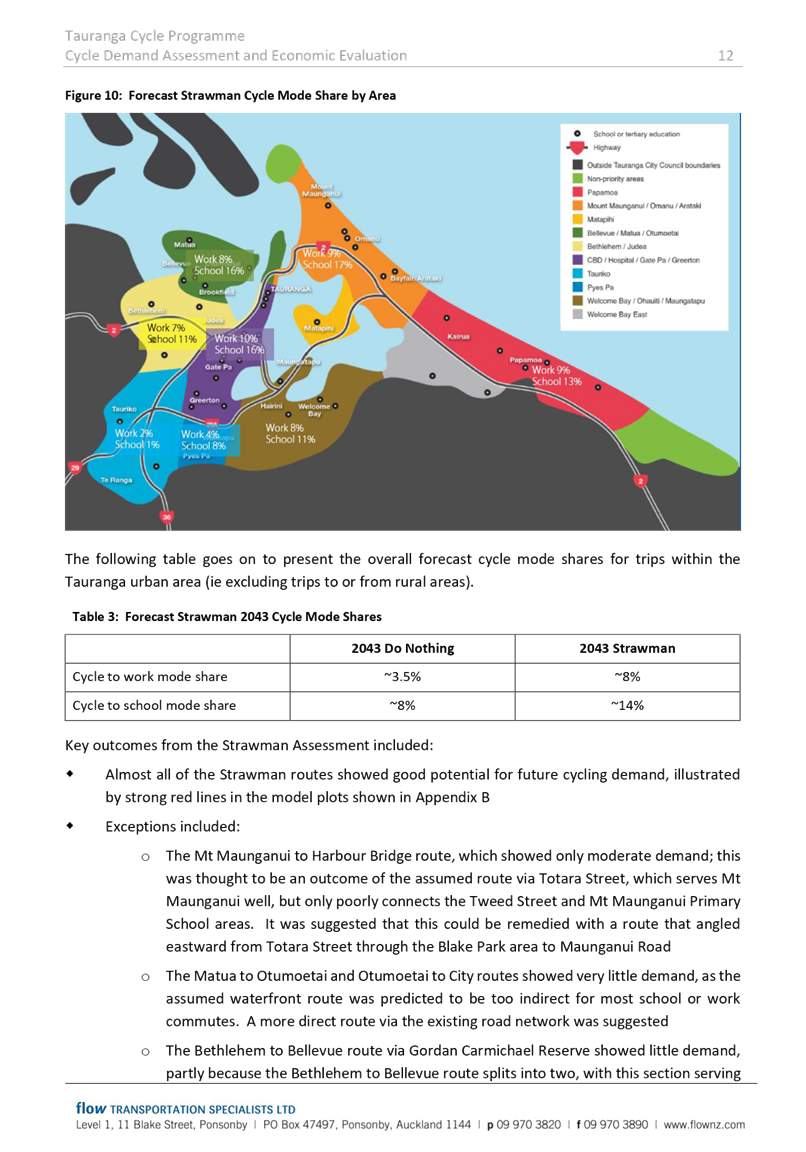


10.6 Innovating
Streets
File
Number: A11425194
Author: Doug
Spittle, Team Leader: Urban Spaces
Authoriser: Gareth
Wallis, General Manager: Community Services
Purpose of the Report
1. Outline projects
recommended for inclusion in applications to the Innovating Streets fund
through Waka Kotahi (NZ Transport Agency).
|
Recommendations
That the Council:
(a) Receive Report –
Innovating Streets.
(b) Approve projects to be
included in applications to the first Innovating Streets funding round
(recommended projects to be tabled at meeting).
|
Executive Summary
2. Waka Kotahi (NZ Transport
Agency) has made available an Innovating Streets fund, which will provide a 90%
Funding Assistance Rate for successful projects. The fund aims to support
tactical urbanism projects such as pilots, pop ups and interim treatments that
make it safer and easier for people to move around or access community spaces.
3. The fund is primarily
about creating safe and attractive streets for pedestrians, cyclists and other
non-car modes of travel. The fund does not seek to fund permanent treatments
but does seek to demonstrate the value of potential future permanent changes to
the community.
4. The impact of Covid-19 is
relevant to how the fund will be administered. The need for social distancing
changes the space required for people to move through the city. Further, Alert
Level 4 lockdown led to significant changes to how people interact with their
neighbourhoods and meet their daily needs.
5. Staff are preparing a
short list of projects recommended for inclusion in applications to the Innovating
Streets fund. At the time of preparing this report, this work has not been
completed and the list of recommended projects will be tabled at the meeting.
6. There are two funding
rounds for the fund. The first funding round closes on 8 May 2020. The second
funding round closes on 3 July 2020.
Background
7. On 3 April 2020, Waka
Kotahi launched the Innovating Streets fund. This fund was initially allocated
$7M, however Waka Kotahi have indicated that significantly more funding could
be made available to the fund from underspent areas of the National Land
Transport Fund.
8. Covid-19 has recalibrated
how Waka Kotahi will assess applications and the scale of need for temporary
initiatives to improve the safety and experience for people in our streets.
9. The fund is encouraging
innovative solutions to improve how our streets cater for all users. Examples
provided on the Waka Kotahi website for the types of projects that could be
considered include:
(i) interim intersection
safety improvements;
(ii) projects to improve place
making;
(iii) projects that reinforce the
context of the street;
(iv) one-off events to help cities
embrace other modes of transport;
(v) regular play-street programmes
that build community support for re-purposing streets;
(vi) low-traffic neighbourhoods that aim
to reduce vehicle volumes;
(vii) piloting a cycleway, pedestrian or
public transport network; and
(viii) emergency bike lanes of footpath
expansions to make more space for social distancing in response to Covid-19.
10. It is important that the projects
can be delivered quickly; there is alignment to Council’s own strategies
and plans – alongside the criteria set by Waka Kotahi; and that the
projects represent value for money. The Waka Kotahi website indicates the
following weighting will be given to these criteria:
(i) Strategic fit with
Innovating Streets and council plans (40%)
(ii) Ability to deliver (40%)
(iii) Value for money (20%)
Strategic / Statutory Context
11. Potential projects identified by
staff are supported by Council strategies and plans that seek to improve the
safety and attraction of active transport modes, and also creating quality
urban environments that encourage higher densities of housing. These are
priorities for Council at present in terms of managing growth in a way that is
affordable and sustainable. Specific relevant strategies include
(i) Urban Form and Transport
Initiative
(ii) Te Papa Spatial Framework
(iii) City Centre Spatial
Framework
(iv) Cycle Plan
12. The focus on creating safe and attractive
streets for active modes and creating great urban places also supports the
direction of the Government’s Urban Growth Agenda, and the Government
Policy Statement on Land Transport.
Options Analysis
13. Staff have worked through a long
list of potential projects and assessed against the relevant criteria. The
short list of recommended projects was not available at the time of preparing
this report and will be tabled at the meeting.
14. Broadly, the options available to
Council are:
(i) support the recommended
projects for applications to this first funding round (Recommended); or
(ii) support a reduced number of
projects for applications to this funding round, or
(iii) not to support any
applications to this funding round.
Financial Considerations
15. The Innovating Streets fund provides
for 90% funding assistance to successful projects. It will be confirmed at the
meeting for the recommended projects whether the 10% Council contribution is
available within existing 20/21 budgets, or alternatively whether additional
budget needs to be identified.
Legal Implications / Risks
16. The projects identified need to be
delivered quickly and be low risk in terms of the legal implications or
processes required. This has been a key criteria for staff to consider in
developing the short list of recommended projects.
Consultation / Engagement
17. Some of the short-listed projects
have already had some community consultation and engagement undertaken. Those
projects, and any others that are entirely new concepts, will require further
engagement to explain the rationale for projects to the community, and also
targeted engagement with any parties particularly affected by the initiatives.
Significance
18. The initiatives proposed are all
temporary in nature. Given the high level of funding assistance potentially
available from Waka Kotahi there is low financial impact for the projects, with
the Council contribution likely to be able to be supported through existing
budgets (to be confirmed at meeting). The significance of matters outlined in
this report are therefore assessed as low.
Next Steps
19. Submit application to Waka Kotahi by
8 May 2020.
20. Design and implement approved
projects.
Attachments
Nil
|
Ordinary Council
Meeting Agenda
|
5 May 2020
|
10.7 Deliberations
on and adoption of the Coastal Structures Policy 2020
File
Number: A11090471
Author: Emma
Joyce, Policy Analyst
Ariell King, Team Leader:
Policy
Authoriser: Christine
Jones, General Manager: Strategy & Growth
Purpose of the Report
1. To approve options in
response to submissions to the draft Coastal Structures Policy and adopt the
Coastal Structures Policy 2020 (attachment one).
|
Recommendations
That the Council:
(a) Adopts the Coastal Structures
Policy 2020 (attachment 1), which includes the following changes from the
draft consulted policy:
(i) adding
a requirement that privately maintained protection structures cannot impede
public access, particularly where they are located on an esplanade reserve;
or otherwise interfere with the purpose of the reserve
(ii) replacing the provision
allowing the construction of new protection structures on council land with a
new clause that “no new private protection structures are permitted on
council land”
(iii) add “or fund”
to draft clause 5.1.4 stating that council does not build or maintain
structures where the primary benefit is promotion of private or commercial
interests, or the protection of private property or commercial interests.
(iv) retaining the current statement
that any private protection structure built or maintained under this policy
must be up to current council standard and at the sole cost of the private
property owner
(v) replacing
“moving” with “relocating” in clause 5.2.4 relating
to alternative options to hard protection structures
(vi) moving reference to consideration
of mana whenua values and connection to the area when making management
decisions to a separate clause
(vii) adding “effects on historic
heritage sites and values” to schedule one and require schedule of
criteria to be considered for both hard and soft protection options
(viii) adding Heritage New Zealand Pouhere
Taonga Act 2014 to the list of relevant legislation
(ix) specifying in a policy note that
resource consent is required from Bay of Plenty Regional Council and that all
coastal structures need to consider regional coastal and environmental plans
(x) specifying in a policy note that
new hard protection structures may require building consent
(xi) specifying in a policy note that
council-owned protection structures are not adequate provision to protect
private land from natural hazards as per section 71 of the Building Act 2004
(xii) add an additional criterion to
schedule one requiring consideration of funding availability when making
decisions on coastal structures
(b) Notes that no changes are
proposed to the overall intent of the policy purpose, scope and general
principle to prioritise protection of significant council activity and
assets.
(c) Delegates authority to the
General Manager Strategy and Growth to make minor editorial changes to the
Coastal Structures Policy 2020 for correction or clarification.
|
Executive Summary
2. Council’s current
2006 Coastal Structures Policy required review to ensure that it aligns with
the current policy and legislative framework. In particular, the review looked
at how council could better manage assets and activities protected by a
structure, and the role of council in protecting private property. Consultation
on the draft Coastal Structures Policy 2019 (draft policy as consulted) was
undertaken in October and November 2019. A copy of the draft policy as
consulted is appended at attachment two.
3. This report provides an
opportunity for Council to deliberate on all submissions received and to agree
an option to address issues raised in the submissions prior to adopting the
final Coastal Structures Policy 2020. A summary of submissions is appended at
attachment three.
Background
4. The 2006 Coastal
Structures Policy responded to a regional council requirement that all
structures in the coastal marine area must have a resource consent. As such,
this council required a policy that determined which structures we owned, would
continue to maintain, and therefore required a regional resource consent. Under
the current policy, council accepts ownership and future management of
structures that provide “community benefit” regardless of land
ownership. Council will not maintain structures where the substantial benefit
is the promotion of private or commercial interests.
5. Changes in the policy and
legislative framework since 2006 mean it is appropriate that Council
re-evaluates the continued existence and maintenance of hard protection
structures (seawalls, groynes, rock revetments). Recent Ministry for the
Environment (MfE) advice recommends councils develop flexible policies that
ensure management of protection structures is responsive to climate change
hazards. This reflects the Local Government Act 2002 (LGA 02) requirement that
councils plan “effectively for the future management of its
assets”. Similarly, the ongoing maintenance of structures at risk from
coastal effects may not meet the financial prudence test in the LGA 02.
6. The draft policy adopted
by the Policy Committee at its July 2019 meeting reflected this policy and
legislative framework by;
· clarifying
the policy purpose as guiding the current and future management of
council-owned coastal structures (both hard protection structures and other
structures with recreational benefits such as jetties and wharves)
· confirming
the purpose of hard protection structures as protecting council activity and
not to guard against future sea level rise
· providing
a means to prioritise the protection of our most significant activity and
assets and allowing for decisions not to maintain or remove some structures
· recognising
that a council-owned protection structure may provide secondary benefit to
adjacent private land.
7. In providing a means to
prioritise investment in protection structures, the draft policy requires that
we first consider if the asset or activity could be protected through
alternative approaches such as soft protection or managed retreat. For example,
a structure was not used to protect the surf lifesaving club building from
erosion on a Kāpiti beach and instead it was agreed to relocate the
building to a less erosion prone location. The activity (surf lifesaving
building) can continue without the need for a protection structure. The draft
policy allows for similar decisions in Tauranga. This financially prudent
approach means that council may not maintain protection structures where the
activity or asset is of low significance.
8. The policy purpose and scope
do not reference protection of private property. The draft policy retains
reference to councils having no legal obligation to protect private property
from naturally occurring erosion. However, the draft policy proposed two new
provisions that would allow private landowners to assume maintenance of
existing structures (where council has decided not to maintain) and
consideration of requests to build private protection structures on
council-owned land where it was necessary for the protection of private property.
This is discussed further below as part of issue two.
9. These changes were
incorporated into a draft policy for consultation. The consultation document
provided respondents with the option of answering just two questions or also
providing a lengthier written submission. A total of 75 submissions were
received during the consultation period (October and November 2019). The
majority (39) were in support with 12 in opposition. The remaining submissions
were neutral or commented on issues outside the scope of the policy review.
10. Staff have analysed the submissions
and provide recommendations to Council for the matters raised through the
submission process.
Strategic / Statutory Context
11. The LGA 02 requires councils to
consider the “interests of future as well as current communities”
and to plan “effectively for the future management of its assets”.
This includes consideration of climate change effects.
12. In making decisions on coastal
structures, this council needs to be aware of the New Zealand Coastal Policy
Statement (NZCPS) and regional planning documents. In particular, the NZCPS
discourages private protection structures on public land. The draft policy as
consulted is inconsistent with that principle. This inconsistency is noted in
issue two. Bay of Plenty Regional Council (submission number 49) have
recommended including explicit reference to the Regional Coastal Environment
Plan in the policy.
13. Separate to this policy review,
council is undertaking a number of related projects to meet obligations under
the Resource Management Act 1991 (RMA 91), district and regional plans, and
national policy statements. This includes the recent coastal hazards study, the
resilience project, and plan change development. The draft policy is not a response
to this work.
14. The Auditor-General has recommended
that councils better reference climate change in their next long-term plans.
While the draft policy addresses climate change related issues, the draft
policy is not in itself a climate change policy (or a policy on adapting to sea
level rise). Council will need to consider its response to climate change in
preparing the next long-term plan.
Legal Implications / Risks
15. This policy is developed under the
LGA 2002, particularly the requirements of section 14 that councils plan
“effectively for the future management of its assets” and meeting
the needs of current and future communities. Overall legal responsibility for
coastal protection works is shared between different levels of government and
potentially seven different statutes. This has created a level of “legal
uncertainty”[13].
Responding to this uncertainty is an emerging issue for local government.
16. In the absence of clear direction,
all decision-making with regards to coastal structures should be well-evidenced
and follow correct procedure to mitigate any risk of future legal challenge.
While this policy review addresses some of that legal uncertainty, it does not
completely mitigate the risk of future court decisions regarding coastal erosion
and coastal protection going against council. The recommended changes to the
draft policy suggested in this report have been subject to legal review with
subsequent advice incorporated into this report. In particular, a statement has
been added to the draft policy (draft clause 5.1.6) noting that it should not
be presumed a structure currently in existence and maintained will exist and be
maintained in perpetuity. If Council resolves changes to the recommended
policy it may be necessary to seek further legal review.
17. Councils also have obligations to
protect reserves under the Reserves Act 1977 and to maintain reserves in
accordance with their purpose and classification. One of the purposes of
esplanade reserves is provision of public access to the water. Protecting an
esplanade reserve may require the installation of a protection structure. The
relationship between this requirement and the RMA 91 rule that esplanade
reserves should support the natural functioning of the coastline is unclear. As
such, schedule one of the draft policy reflects the need to ensure
consideration of the purpose of the reserve when deciding management options.
18. During the policy review process,
staff identified a risk that private landowners may claim that an existing council-owned
and maintained protection structure is “adequate provision” to
protect land from natural hazard risk in order to obtain a building consent
under section 71 of the Building Act 2004. The issuing of a building consent
based on the existence of a council-owned structure could imply council would
continue to maintain a protection structure even when it no longer protects a
council activity or asset. This is discussed further in the options section
below.
19. The Marine and Coastal Area (Takutai
Moana) Act 2011 (MACA 11) states that nobody owns or is capable of owning the
common marine and coastal area. However, MACA 11 allows for retention of
interest in private structures as personal property, including those structures
maintained by councils prior to MACA 11. Therefore, Council needs to be aware
that the policy does not apply to coastal land (land below the mean high water
spring line) per se but coastal structures in the ownership of council.
20. Councils are not legally required to
protect neighbouring land from naturally occurring erosion. However, private
landowners may have expectations of council support or that the council
protection structure providing default protection to their property will be
maintained in perpetuity.
21. Any potential health and safety risk
arising from a decision not to maintain a structure will require management at
the time.
Options Analysis
22. Paragraphs 24 to 47 below outline
options and recommendations in response to the issues raised in submissions
(see attachment two for summary of all submissions). Recommended options are
highlighted in the draft policy for adoption (attachment one). In
analysing feedback received on the draft policy, five issues were identified
where consideration should be given to amending the policy to reflect feedback
received in the submissions.
23. The issues highlighted in submissions
include;
· Support for the
policy review
· Approach to the
protection of private land adjacent to reserves and other council land
· Funding of protection
structures with private benefit
· Criteria for
maintenance decisions
· Consenting.
24. Submitters also commented on issues
outside the scope of the policy. These issues included objections to city plan
rules, Mauao base track repairs, the coastal hazards mapping work, and historic
encroachments into the esplanade reserve. Responses to these issues are
included in the attached submissions summary. However, no amendments to the
draft policy are required.
Issue one: Support for
the policy review
25. Council maintains just under 15,000
metres of structures around the coastline. The overall purpose of the policy is
to guide the current and future management of council-owned coastal structures.
Rather than treating all coastal structures equally (as is under the 2006
policy), the draft policy proposes that management decisions for protection
structures require consideration of the significance of the asset or activity
protected by a structure. Similarly, management decisions for all other
structures will be informed by an assessment of the significance of the
structure. Therefore, under the draft policy, structures that protect an
activity of low significance (such as an unconnected walkway), or other
structures of low significance, will not automatically be maintained and may be
removed. This approach ensures a financially prudent and future focused
approach to the management of coastal structures.
26. We included a specific question in
the consultation material asking whether respondents agreed that we should
prioritise management of structures that protect our most essential public
assets. Of the 53 respondents who answered this question, 46 were in support.
27. In response to issue one, Council
could choose to continue the policy review, retain the existing 2006 policy,
develop a policy that requires council to maintain all structures in its
ownership, or to ensure rates funding is available to maintain all structures.
The advantages and disadvantages of these four options are outlined in table
one below.
Table 1: Options and
recommendation in response to issue one
|
Option
|
Advantages
|
Disadvantages
|
|
1.1
|
Continue with policy
review
(recommended)
|
· Aligns with the LGA 02
requirement for future-focused asset management, including climate change effects.
· Financially prudent
approach to protect our most significant assets and activity.
|
· Not all structures
will be maintained, including structures that may have a secondary benefit of
protecting adjacent private property
|
|
1.2
|
Retain current 2006 policy
|
· Greater certainty that
all structures will be maintained
|
· May not meet the LGA
02 requirement for future-focused asset management, including the impact of
climate change
· Maintenance of
structures at risk from erosion may require additional budget for repair
· Limited flexibility to
make financially prudent decisions not to maintain structures at risk of
erosion and other coastal effects
· All ratepayers
potentially funding structures that have limited public benefit but secondary
benefit to protect private property.
|
|
1.3
|
Policy should ensure
that council prioritises the maintenance of all structures in its ownership
|
· ·
| 1.4 |
Policy should ensure
that council prioritises the maintenance of all structures in its ownership
through rates funding
|
· Certainty that all
structures will be maintained and funded through general rates.
|
·
Issue
two: Approach to the protection of private property adjacent to reserves and
other council land (draft section 5.3)
Private
maintenance of council-owned coastal structures
28. The draft policy requires council to
prioritise the maintenance of those protection structures that protect
significant assets or activity. This means some protection structures will be
accorded a low priority for maintenance, or simply not maintained. However, some
structures protecting council esplanade reserves or other activities and
assets have a secondary benefit in protecting private property from erosion. As
such, the draft policy proposed allowing private landowners to take over
maintenance of protection structures no longer required by council, but which
provided necessary protection to their property.
29. Draft clause 5.3.2 states that
“Where it has been
determined that the existing hard protection structure does not protect a
significant activity or asset or where the primary benefit is the protection
of private property or commercial interests, Council may enter into
maintenance or ownership agreements with affected private property owners”.
Submissions supported allowing private maintenance of protection
structures, however, some submitters expressed concern that this may lead to
privatisation of public space.
30. With regards to private maintenance
of existing structures, Council could decide to either retain the draft policy
provision allowing maintenance of existing structures, add an additional
requirement that structures should not interfere with public access or other
purpose of the reserve, or remove the draft provision. The advantages and
disadvantages of each option is outlined in table two below.
Table 2: Options and
recommendation in response to allowing private maintenance of structure
|
Option
|
Advantages
|
Disadvantages
|
|
2.1.1.
|
Allow for private
maintenance of protection structures (as consulted on in draft policy)
|
· Flexibility for
council staff to work with private landowners on issues of accessibility.
· Provides greater
certainty for private landowners adjacent to reserve land potentially at
risk from erosion.
|
· Does not address
concerns about potential loss of public access
|
|
2.1.2
|
Add “so long as
the structure does not impede public access or otherwise interfere with the
purpose of the reserve” to draft clauses 5.1.5 and 5.3.3 allowing
private maintenance of protection structures
(recommended)
|
· Allows council to
work with landowners to maintain existing protection structures on council
reserves that benefit adjacent landowners.
· Private maintenance
of existing structures may be undertaken using council’s existing
resource consent(s) for this purpose.
· Ensures that any
structures do not impede public access or the purpose of the reserve
|
· Nil
|
|
2.1.3
|
Do not allow private
maintenance of protection structures
|
· Eliminates concerns that
private maintenance of structures may limit public access or otherwise
interfere with the purpose of the reserve
|
· Some landowners may
be unable to protect their land from erosion or coastal effects without
maintenance structure
|
New
private protection structures on council land
31. The 2006 policy states that no
private structures (either hard protection structures or structures with
recreational benefits like jetties) can be constructed on public land. This is
consistent with council’s own Encroachments onto Reserves Policy (under
review), the NZCPS, and the purpose of esplanade reserves as defined in the
RMA 91. The draft policy as consulted proposed to relax the 2006 rule. New
private protection structures on council land would be permitted where
necessary to protect private property. (The draft policy would continue to
prohibit private structures with mainly recreational or amenity benefits,
defined as “other structures” in the draft policy.)
32. Submitters were invited to answer
the question “Do you agree with allowing private landowners to take over
the ownership and maintenance of a hard protection structure, or build
a hard protection structure on Council land, to protect their
property?”. Of the 53 people who answered this question, 27 were in
support (26 against). This includes private property owners who would be
affected by any future decision not to maintain a seawall.
33. The draft policy as consulted
included a clause stating that “Council may allow the construction of
new hard protection structures on Council-owned land to protect private
property”. Comments on this topic considered issues around potential
loss of public access to esplanade reserves and council abdicating its
responsibility to maintain seawalls. In response the issue of new private
protection structures on council land, Council could choose to retain the
clauses as in the draft policy as consulted, amend to note that new private
protection structures cannot impede public access, or continue to prohibit new
private protection structures. The table below outlines the advantages and
disadvantages of each option.
Table
3: Options and recommendation in response to allowing new private protection
structures on council land
|
Option
|
Advantages
|
Disadvantages
|
|
2.2.1
|
Allow new private
protection structures on council land (as consulted on in draft policy)
|
· Flexibility for
council staff to work with private landowners on issues of accessibility.
· Provides greater
certainty for private landowners adjacent to reserve land potentially at
risk from erosion.
|
· May create risk of
legal liability or expectations of future financial support by allowing new
protection structures on our land
· Does not address
concerns about potential loss of public access
· No guarantee that a
private landowner would be granted consent for a new private protection
structure (regardless of the land it would sit on).
· Inconsistent with
national and regional planning frameworks discouraging new hard protection
structures
· Inconsistent with
council’s Encroachments on to Reserves Policy
· Potential for
inconsistent management approach where we allow private structures in one
part of the city while removing them elsewhere
|
|
2.2.2
|
Delete provisions
allowing new private protection structures and replace with a new clause
stating, “No new
protection structures with a primarily private or commercial benefit are
permitted on Council-owned or administered land.”.
(recommended)
|
· Aligns with national
and regional planning frameworks discouraging new hard protection structures
· Addresses concerns
about potential loss of public access
· Reduces potential for
inconsistent management approach across the city whereby council requires
removal of structures in one location but allows them elsewhere.
· Consistent with
current policy and council’s Encroachments on to Reserves Policy
· Consistent with the
purpose of esplanade reserves in the RMA 91
|
· Some landowners may
be unable to protect their land from erosion if they are unable to build
protection structures on council land
· May hinder the
issuing of some building consents where the building work is on land likely
to be affected by natural hazards
|
|
2.2.3
|
Add “so long as
the structure does not impede public access or otherwise interfere with the purpose
of the reserve” to draft clause 5.2.5 allowing new private protection
structures on council land
(recommended only if
option 2.2.2 not supported)
|
· Provides greater
certainty for private landowners adjacent to reserve land potentially at
risk from erosion.
· Addresses concerns
about potential loss of public access.
· Consistent with part
of the purpose of esplanade reserves in the RMA 91
|
· May create risk of
legal liability or financial support by allowing protection structure on
council land
|
34. If
Council decided to allow private protection structures on council land, a note
should be added to the policy that council reserves its right to be consulted
as an affected party as part of any resource consent application. Landowner
permission for a new protection structure granted through the policy should
not be interpreted as landowner permission for resource consent purposes.
Issue
3: Funding arrangements for privately maintained structures (draft clauses
5.1.2 and 5.2.6)
35. Councils do not have to fund or
build structures to protect private property or commercial interests. The
draft policy as consulted only implied that council does not fund private
protection structures. Other provisions in the draft policy as consulted
state that hard protection structures maintained or built under relevant
provisions of the policy “must be maintained to an approved standard at
the cost of the private landowner and be consistent with current council
policy”. The draft policy contains no other references to funding
private protection structures.
36. Submissions commenting on funding
raised the issue of cost-sharing or other targeted rates for maintenance of
protection structures that provide some protection to private property. Other
submissions noted that maintenance of all coastal structures should remain a
function of council.
37. In response to issue three, Council
could add “or fund” to draft clause 5.1.4 making it clearer our
role in funding structures with private benefit, retain draft clause 5.3.3
stating that private landowners must meet all the costs of maintaining
structures where they have assumed ownership under relevant provisions of the
policy, or for the policy to remain silent on funding arrangements for
privately maintained structures. If Council decides not to agree to
recommended option 2.2.2 above, funding statements would apply to new
protection structures as well.
Table 4: Options and
recommendations with regards to funding arrangements for privately maintained
structures or new private protection structures on public land
|
Option
|
Advantages
|
Disadvantages
|
|
3.1
|
Add “or
fund” to draft clause 5.2.2 stating council’s approach to
structures protecting or promoting private and commercial benefit
(recommended)
|
· Aligns with purpose
of the draft policy to ensure council funds only those structures that
protect our most significant assets and activities
· Consistent with
current policy
|
· Nil
|
|
3.2
|
Private maintenance of
structures is at the sole cost of the private property owner (not council)
(and new protection structures subject to decision on issue 2.2).
(status quo)
(recommended)
|
· Consistent with the
draft policy as consulted
· Aligns with purpose
of the policy to ensure council funds only those structures that protect our
most significant assets and activities
· Any future
discussions on cost sharing can be held as part of the annual plan and
long-term plan development
|
· Limited flexibility
to work with landowners on maintenance and cost sharing issues.
|
|
3.2
|
Provide in the policy
for shared funding agreements for maintenance of protection structures
|
· Provides landowners
with certainty of some council support to maintain structures
· Flexibility to work
with private landowners on maintenance issues, including cost-sharing arrangements
|
· Inconsistent with
purpose of policy to ensure council funds only those coastal structures with
significant public benefit
· Potential for all
ratepayers to be funding structures with limited or no public benefit
· Potential for funding
decisions to be made outside annual plan or long-term plan
· May create
expectations of ongoing council support
|
|
3.3
|
Provide in the policy
for shared funding agreements for new protection structures*
*(only required if
Council does not agree to option 2.2.2 above).
|
· Provides landowners
with certainty of some council support
|
·
| 3.3 |
No comment in policy on
funding agreements for privately maintained structures (and new protection
structures subject to a decision on issue 2.2 above)
|
· Flexibility to work
with private landowners on maintenance issues, including cost-sharing
arrangements
· Allows all funding
and maintenance agreements to be negotiated between all parties.
|
· Potential for all
ratepayers to be funding structures with limited or no public benefit
· Potential for funding
decisions to be made outside annual plan or long-term plan
|
Issue
4: Criteria for assessing when Council will maintain, renew or remove
structures (draft section 5.2 and schedule one).
38. The current policy has wide-ranging
criteria for deciding when Council would maintain, retain, or build a
structure. (The current policy does not note the possibility of removal).
There is no requirement to consider the significance of the activity protected
by a structure before deciding whether to
“maintain/retain/install” a structure.
39. The draft policy proposes more
specific criteria for determining management options. Moreover, it first
requires all decisions on the future of a structure to consider the
significance of the activity to be protected, and whether the activity can
continue without a structure, for example, through soft protection (planting,
sand replenishment) or managed retreat. Submitters generally supported the new
assessment criteria and the requirement to consider alternative options to
hard protection structures.
40. Submitters also made suggestions to
enhance the criteria by
· Stronger
reference to consideration of mana whenua values
· Reference to
consideration of protection of historic heritage values
· Adding
consideration of funding availability
· Requiring the
schedule one criteria to be applied to soft protection measures
· Wording
changes.
41. The draft policy as consulted
included a requirement to consider mana whenua values as a sub-clause, not a
standalone clause. The table below outlines the advantages and
disadvantages of adding a specific clause requiring consideration of mana
whenua values.
Table
5: Options and recommendations in response to man whenua values
|
Option
|
Advantages
|
Disadvantages
|
|
4.1.1
|
Make criteria requiring
consideration of the significance of area to mana whenua standalone
(recommended)
|
· Requirement to
consider significance to mana whenua clearer in the policy
· Aligns with responsibility
towards protecting Māori sites of significance under the RMA 91
|
· Nil
|
|
4.1.2
|
Retain reference to
significance of area to mana whenua as part of a subclause
|
· Nil
|
· Requirement to
consider significance to mana whenua less obvious in the policy
|
42. The
draft policy requires consideration of alternative options to hard protection
structures when determining how to protect an asset or activities at risk from
coastal effects. Alternative options include moving the asset or activity
(managed retreat). Bay of Plenty Regional Council suggested using
“relocating” instead of “moving” in the relevant draft
clause. The advantages and disadvantages of this minor change in language is
discussed in table six below.
Table 6: Options and
recommendation in regard to minor change in language
|
Option
|
Advantages
|
Disadvantages
|
|
4.2.1
|
Replace
“moving” with relocating in clause 5.2.4
(recommended)
|
· Aligns with language
used by Bay of Plenty Regional Council
|
· Nil
|
|
4.2.2
|
Retain the wording as
in draft policy
|
· Nil
|
· Inconsistent with
language used in regional planning documents
|
43. The
2006 policy includes archaeological values as one of the criteria for
determining management options for coastal structures. The draft policy as
consulted did not include specific reference to protection of archaeological
or historic heritage values. Heritage New Zealand made some specific
suggestions to ensure that future decisions on coastal structures management
had appropriate regard to archaeological and historic heritage. These
suggestions are discussed in table seven below.
Table
7: Options and recommendations in regards to protection of archaeological and
historic heritage
|
Option
|
Advantages
|
Disadvantages
|
|
4.3.1
|
Amend schedule one to
include “effects on historic heritage sites and values”
(recommended)
|
· Ensures coastal
structures management has appropriate regard to historical heritage
· Consistent with 2006
policy
|
· Nil
|
|
4.3.2.
|
Do not include
reference to effects on historic heritage sites and values
|
· Nil
|
· May result in no
consideration of effects on historic heritage in coastal structures
management
· Loss of
archaeological remains
|
|
4.3.3
|
Add “Heritage New
Zealand Pouhere Tangata 2014” to list of relevant legislation
(recommended)
|
· Ensures coastal
structures management has appropriate regard to historical heritage
|
· Nil
|
|
4.3.4
|
Do not add Heritage New
Zealand Pouhere Tangata Act 2014 to list of relevant legislation
|
· Nil
|
· May result in no
consideration of effects on historic heritage in coastal structures
management
· Loss of
archaeological remains
|
44. A
key rationale for this policy review was the need to ensure our approach to
coastal structures management is financially prudent. However, there is no
requirement in the draft criteria at schedule one to consider funding
availability. Table 8 below outlines the advantages and disadvantages of
adding “funding availability” as a criterion to consider when
making decisions on coastal structures management.
Table 8: Options and
recommendation on including funding availability in decision-making criteria
|
Option
|
Advantages
|
Disadvantages
|
|
4.4.1
|
Add consideration of
funding availability to schedule one
(recommended)
|
· References purpose of
policy review to ensure financially prudent coastal structures management
|
· Potential for
long-term strategic decisions not being made due to short-term budget
constraints.
|
|
4.4.2
|
Do not add
consideration of funding availability to schedule one (as in draft policy as
consulted)
|
· Nil
|
· No specific
requirement to consider whether a decision is financially prudent
|
45. The
criteria at schedule one only applies to coastal structures. Heritage New
Zealand noted that soft protection measures can also have an impact on
archaeological and ecological values. The table below considers the advantages
and disadvantages of requiring consideration of the criteria at schedule one
of the draft policy when implementing soft protection measures.
Table
9: Requiring consideration of schedule one criteria when implementing soft
protection measures
|
Option
|
Advantages
|
Disadvantages
|
|
4.5.1
|
Add note that the
criteria at schedule one needs to be considered when implementing soft
protection measures
(recommended)
|
· Ensures that soft
protection measures do not effect archaeological or ecological values
· Ensures that soft
protection measures are subject to same scrutiny when determining best
option to protect an asset or activity
|
· Nil
|
|
4.5.2
|
No requirement to
consider criteria at schedule one when implementing soft protection measures
|
· Nil
|
· A decision to employ
soft protection measures may inadvertently have a negative impact on
environmental or archaeological features
|
Issue
5: Resource and building consents for private protection structures
46. The policy sets out how council will
manage activity at risk from erosion in the future. As a policy produced under
the LGA 02, it does not generally comment on issues that are managed through
the RMA 91 or Building Act 2004. As noted in draft clause 2.2, the policy does
not override relevant provisions in the RMA 91. However, the policy does
include a note (under section 5.3) on the requirement for private landowners
to apply for resource consent.
47. As noted in paragraph 17 above,
there are future potential legal risks where building consents may be issued
for building on land subject to natural hazards based on an existing council
protection structure providing appropriate mitigation. This was alluded to in
the verbal submission from Mike Olsen (submission number 68).
48. The table below outlines the
advantages and disadvantages of options identified in responding to
submissions with regards to consenting issues.
Table 10: Options and
recommendations in response to issue 5
|
Option
|
Advantages
|
Disadvantages
|
|
5.1
|
Amend note to specify
resource consent from Bay of Plenty Regional Council and possible building
consent from Tauranga City Council
(recommended)
|
· Clarifies that BOPRC
is responsible for issuing resource consents for activity in the coastal marine
area.
|
· Nil
|
|
5.2
|
Amend note to specify
that structures need to consider regional coastal and environmental plans
(recommended)
|
· ·
| 5.3 |
Add new clause
specifying that council-owned and maintained protection structures cannot be
used as adequate provision for the purposes of obtaining a building consent
under section 71 of the Building Act 2004
(recommended)
|
· Avoids entering into
an implied agreement to maintain protection structures as building consent
was issued on the basis of the structure being mitigation for natural
hazards.
· Aligns with the
purpose of protection structures to protect significant council activity and
assets.
|
· Some private
landowners may have greater difficulty in obtaining building consents for
building on land subject to natural hazards
|
other issues
49. Submissions raised issues related to
sea level rise, climate change planning, and the costs of consenting new
seawalls. While these issues are outside the scope of this policy review,
responses to the issues raised are provided in attachment two as part of the
summary of submissions.
Financial Considerations
50. As noted in response to issue one, a
policy that supports prioritisation of structures that protect significant
activity will enable financially prudent decisions on asset management in the
future. At present, there is budget in the long-term plan for structures
management. However, it is likely costs for managing these assets will
increase in the future as a result of climate change effects.
51. Issue three discussed the issue of
financial compensation for private landowners who take over the maintenance of
structures and wish to install new protection structures (should provision for
new protection structures be retained). The recommendation is that no funding
considerations be specifically included in the policy. This provides council
with flexibility to enter into conversations with private landowners who may
wish to take on responsibility for a protection structure where it has been
determined that the protection structure does not protect a significant
council activity, or where the primary benefit is protection of private or
commercial interests. It also ensures that funding conversations take place as
part of the annual plan or long-term plan deliberations.
52. A response to the issue of consent
fees is provided in attachment three as part of the summary of submissions as
it is an operational matter outside the policy scope. Some costs are set by
Bay of Plenty Regional Council and cannot be changed by a decision of this
council.
Consultation / Engagement
53. A total of 75 submissions to the
draft policy were received during the consultation period (14 October to 17
November).
54. Staff sent letters to approximately
1000 landowners with property adjacent to esplanade reserves who may be
affected in the future by the changes proposed in the draft policy. Some
residents and property owners contacted staff to talk through the implications
for their individual properties.
55. Community groups and residents’
organisations were also contacted and invited to make a submission.
Significance
56. Under the Significance and
Engagement Policy, this policy review is of medium significance as it has
moderate public interest and consequences for Tauranga.
Next Steps
57. Subject to decisions at this Council
meeting, the adopted policy will be made available on the Council website
following a final legal review. The Coastal Structures Policy 2020 will
replace the current 2006 policy. All submitters to the policy will be advised
of the policy adoption and be provided with an organisational response to the
specific points raised in their submission.
58. The policy responds to the likely
effects of climate change on council-owned structures. However, there is no
broader climate change policy or strategy for Tauranga. Council will need to
consider climate change responses in the development of the next long-term
plan.
Attachments
1. Draft Coastal
Structures Policy 2020 - A11409924 ⇩ 
2. Draft Coastal
Structures Policy 2019 for consultation - A11281867 ⇩
3. Summary of Submissions
- A11142657 ⇩ 
|
Ordinary Council
Meeting Agenda
|
5 May 2020
|
 DRAFT coastal
structUres
DRAFT coastal
structUres
POLICY 2020
|
Policy
type
|
Council
|
|
Authorised
by
|
Council
|
|
First
adopted
|
26
October 2006
|
Minute
reference
|
M06/109.4
|
|
Revisions/amendments
|
Add
years
|
Minute
references
|
|
|
Review
date
|
This
policy will be reviewed in three years or when required.
|
1. PURPOSE
1.1 To guide
decision-making on the current and future management of Council-owned or
administered coastal structures.
1.2 To ensure
planned management of all Council-owned and managed coastal structures along
the coast and in the inner harbour is responsive to current and future coastal
effects.
2. SCOPE
2.1 The
policy applies primarily to the management of coastal structures on
Council-owned or administered land in the inner harbour and coast. The boundary
of the inner harbour and coast extends along any stream or river to the first
bridge.
2.2 Nothing
in this policy should be taken as overriding district or regional plans
produced under the Resource Management Act 1991.
3. Definitions
|
Term
|
Definition
|
|
Activity
|
Has the same meaning as in the
Local Government Act 2002 and “activities” has a corresponding
meaning.
|
|
Coastal effects
|
Refers to any one or more of the
following: inundation, storm surge, degradation of the coastal structure,
or erosion of the coastal structure’s footings.
|
|
Coastal erosion
|
A
long-term trend of shoreline retreat and/or loss of beach sediment volume
over several decades.
|
|
Council
|
Refers to Tauranga City Council -
the elected member body representing Tauranga City.
|
|
Coastal structures
|
Any
building, equipment, device, or other facility made by people and which is
fixed to land, including council-owned or administered land adjacent to the
foreshore and coastal marine area, land covered by water and the airspace
above land in or adjacent to the coastal marine area and above mean high
water springs. This includes wharves, jetties, seawalls, buildings, or
structures built on wharves or jetties, moorings, ramps, rafts, pipelines,
breakwaters, groynes and other wave attenuation devices, and cables and
transmission lines laid on, over (including in the air space above) or under
the foreshore or seabed.
|
|
Esplanade reserve
|
Has the same meaning as in section 229 of the Resource
Management Act 1991.
|
|
Hard protection structures
|
Includes
a seawall, rock revetment, groyne, breakwater, stop bank, structure retaining
wall or comparable structure or modification to the seabed, foreshore or coastal
land that has the primary purpose or effect of protecting Council-owned or
administered land and activities from a coastal hazard, including erosion.
|
|
Private or commercial benefit
|
a
benefit which relates to non-Council activities, assets or land
|
|
Responsibility
|
Is to
accept ownership of a coastal structure and the implications of ownership
including compliance with legislative, financial, asset management,
managerial, and operational requirements.
|
|
Significance
|
Has
the same meaning as in the Local Government Act 2002.
|
|
Other structures
|
Refers
to coastal structures with primarily a recreational or amenity benefit that
do not serve to protect land from coastal erosion or coastal effects. This
includes wharves, jetties, buildings, ramps, or other structures built on
wharves or jetties.
|
|
Soft protection
|
includes
a range of options, such as beach replenishment or nourishment, planting or
dune care, intended to work with natural processes rather than against them
to protect an activity from a coastal hazard, including erosion.
|
4. Principles
4.1 The
role of Council is to manage the effects of coastal erosion and coastal effects
on Council-owned or administered land and activities.
4.2 Planning
effectively for the future management of coastal structures requires
consideration of the interests of both current and future communities, and the
impact of climate change and coastal effects.
4.3 The
purpose of a hard or soft protection structure is to protect an existing or
future Council activity or level of service from coastal effects and not to
guard against future potential sea level rise by or in itself.
4.4 It
is appropriate for Council to reduce the number of hard protection structures,
and evaluate the continued existence and maintenance, of all coastal structures
in its management. There may be instances where Council decides to remove
coastal structures, including hard protection structures protecting
Council-owned or administered land and activities from erosion or coastal
effects.
4.5 Council
has no general obligation to protect private land from the encroachment of the
sea, by way of naturally occurring coastal erosion or otherwise.
5. Policy Statement
5.1 General
approach to coastal structures
5.1.1 Council will consider the
significance of the area to mana whenua in determining options for managing
coastal effects and coastal structures.
5.1.2 Council
will consider the ability of the wider community to fund the whole of life
costs of a coastal structure when determining if a new coastal structure is
required.
5.1.3 Council
does not accept responsibility for coastal structures with primarily a private
or commercial benefit.
5.1.4 In
general, Council does not fund, build,
or maintain coastal structures where the primary benefit is promotion of
private or commercial interests, or the protection of private property or
commercial interests.
5.1.5 If a coastal
structure which is for private or commercial benefit is located on esplanade
reserve, Council may allow it to remain in situ unless it is deemed unsafe, was
constructed without permission, impedes public
access, or otherwise interferes with the purpose of esplanade reserves as
outlined in section 229 of the Resource Management Act 1991.
5.1.6 The
existence or maintenance of a Council coastal protection structure is not a
guarantee or representation by Council that the structure will remain in place
or continue to be maintained. Decisions about future management will be
made in accordance with this policy.
5.2 Policy
on hard protection structures that protect Council-owned or administered land
and activities
5.2.1 Council
will maintain hard and soft protection structures where necessary to protect
three waters infrastructure.
5.2.2 Council
will prioritise the protection of transport infrastructure that is most
essential for the long-term functioning of the transport network. Council may,
in some instances, decide not to maintain hard protection structures supporting
transportation infrastructure.
5.2.3 Council
will consider the significance of the activity protected by a hard protection
structure prior to deciding to remove, install, maintain, or renew a hard
protection structure.
5.2.4 Any
decision to remove, install, maintain, or renew a hard protection structure
will include consideration of whether the activity can exist without a hard
protection structure. This could include relocating
the activity (managed retreat) or prioritising soft protection measures.
Council will also consider the criteria at schedule one of this policy when
determining management options for hard protection structures.
5.2.5 Council
will prioritise the protection of esplanade reserves that provide, or have the
potential to provide, continued public access around the coast.
5.3 Policy
on coastal structures that protect private property or commercial interests
5.3.1 No new protection structures with a primarily private
or commercial benefit are permitted on Council-owned or administered land.
5.3.2 Where
it has been determined that the existing hard protection structure does not
protect a significant activity or asset or where the primary benefit is the
protection of private property or commercial interests, Council may enter into
maintenance or ownership agreements with affected private property owners.
5.3.3 Hard
protection structures maintained under clause 5.3.2 of this policy must be
maintained to an approved standard at the cost of the private landowner, be
consistent with current council policy and not
impede public access or otherwise interfere with the purpose of the reserve.
Where a private landowner enters into an agreement to maintain a hard
protection structure, this will be recorded on the property title.
Note: Landowners are required to obtain all necessary
consents, including possible resource consent from the Bay of Plenty Regional
Council, building consent from Tauranga City Council, and approval from Council
prior to maintenance of any hard protection structures on Council-owned or
administered land.
A Council-owned or administered protection structure
is not considered “adequate provision” for the purposes of
obtaining a building consent under Section 71 of the Building Act 2004.
5.4 Policy
on other structures
5.4.1 Any
decision to remove, install, maintain, or renew other structures will include
consideration of the significance of the structure and the criteria at schedule
one to this policy.
5.4.2 Council
does not permit other structures with a primarily private or commercial benefit
to be constructed on Council-owned or administered land.
6. Relevant Delegations
6.1 The
Chief Executive or their delegate is responsible for the implementation of this
policy.
7. References and
Relevant Legislation
7.1 Building
Act 2004
Heritage New Zealand Pouhere Taonga Act 2004
Local Government Act 2002
Resource Management Act 1991
Bay of Plenty Regional Coastal Environment Plan
8. ASSOCIATED
POLICIES/PROCEDURES
8.1 Encroachments
onto Reserves Policy
Community, Private and
Commercial Use of Council-Administered Land Policy
9. schedules
Schedule one: Criteria to be
considered as part of decisions on coastal structures management, including soft protection options
|
Criteria
|
|
Funding availability and priorities
|
|
The purpose of the reserve, particularly if it is an esplanade
reserve acquired for public access
|
|
Effectiveness of the coastal structure in preventing erosion (does
not apply to other structures)
|
|
Effects of the coastal structure on the environment
|
|
Effects of the coastal structure on historic
heritage sites and values
|
|
Health and Safety
|
|
Community views
|
|
Alternative options to hard protection structures (does not apply to
other structures).
|
|
Ordinary Council Meeting Agenda
|
5 May 2020
|

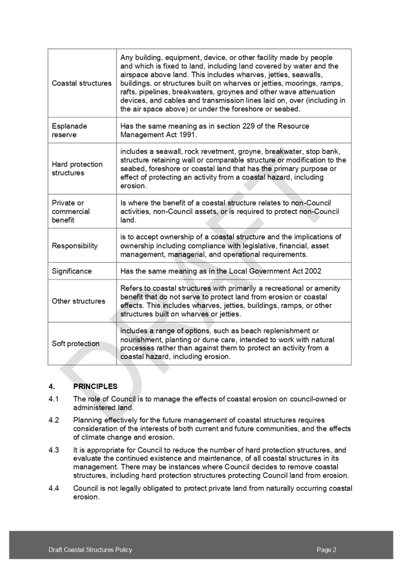


|
Ordinary Council Meeting Agenda
|
5 May 2020
|
Issue one: Support
for policy review and prioritising significant coastal structures for
maintenance and renewal
|
Submission
|
Issue
|
Option
|
|
32, 40,
44, 64 72, 75
|
Agree
that Council needs to focus on significant assets
|
This issue is discussed in paragraphs 24 to 26 and table one of
the main report.
|
|
49
|
General
support for providing clarity on how we will protect activity in the future
|
|
64
|
Acknowledge
current and future costs of erosion protection
|
|
1, 2,
17, 62, 63, 67
|
Supports
prioritisation but wants Council to continue maintenance of all seawalls
|
|
20, 41,
59, 61, 65,
|
Do not
support prioritisation- council should maintain all seawalls through rates
|
|
61, 66
|
Council
should maintain all seawalls
|
|
72
|
Council
responsible for maintaining seawalls that protect inner harbour walkways as
they are an essential council amenity
|
|
74
|
Need
broader approach and engagement to manage issues of climate change and sea
level rise
|
|
25
|
Policy
review waste of money as sea level increase minimal, existing walls will not
protect against sea level rise
|
Issue
two: Approach to the protection of private property adjacent to reserves and
other council land (draft clauses 5.2.4 and 5.2.5)
|
Submission
|
|
|
8, 14,
15, 32, 42, 44, 49, 53, 75
|
Support
private landowners to take over maintenance
|
This issue is discussed in paragraphs 27 to 33 and tables two and
three of the main report.
|
|
42
|
Support
private landowners to maintain only and prohibit new structures
|
|
50
|
Support
private landowners to maintain only and not restrict public access
|
|
8, 16, 39, 53
|
Support
private landowners to build protection structures on public land
|
|
19, 23,
32, 50
|
Support
with appropriate consenting and guidelines
|
|
44
|
Support
private landowners to take over maintenance subject to an assessment of value
of property and effects assessment
|
|
1, 2,
3, 17, 48, 60, 2, 67
|
Do not
support
|
|
12, 42
|
Do not
support private hard protection structures on public land or construction of
new structures to protect private property
|
|
1, 3,
13, 48, 63
|
Do not
support as will lead to privatisation of public space or loss of public
access
|
|
19, 63
|
Incorrectly
understands that draft policy is transferring ownership of accessways or
reserve land
|
|
35
|
Neutral
– would require careful contract wording and charge against the
property
|
Issue
3: Funding arrangements for privately maintained protection structures
|
Submission
|
Issue
|
Option
|
|
2, 15,
17, 20, 41, 42, 59, 62, 65, 66, 67
|
Maintenance
of seawalls should be funded from rates as a council responsibility
|
This
issue is discussed in paragraphs 34 to 36 and table four of the main report.
|
|
3, 12
|
All
ratepayers should not bear burden of protecting properties in natural hazard
areas
|
|
4
|
Private
landowners who benefit from taking on private structure should compensate
Council
|
|
39
|
Support
landowners who take over maintenance
|
|
18
|
Support
landowners take over maintenance but consider financial ability of landowner.
This liability applies on sale of property.
|
|
19, 59,
65, 75
|
Targeted
rate or other cost sharing arrangement for maintenance of seawalls that
provide benefit for adjacent landowners
|
Issue
4: Criteria for assessing when Council will maintain, renew or remove
structures (draft clauses 5.1.1 to 5.1.7 and schedule one).
|
Submission
|
|
|
54
|
Amend
schedule to include “effects on tangata whenua sites and values”
|
This issue is discussed in paragraphs 37 to 44 and tables five to
nine of the main report.
|
|
54
|
Add
“Heritage New Zealand Pouhere Tangata 2014” to list of relevant
legislation
|
|
54, 57
|
The
policy does not specifically mention the effects of protection structures on
archaeological and cultural areas
|
|
54
|
Soft
engineering approaches can also damage archaeological sites. Schedule one
should apply to both soft and hard protection options.
|
|
49
|
Add
“relocation” to draft clause 5.1.4
|
|
44
|
Hard
protection structures last port of call
|
|
28
|
Managed
retreat as preference
|
|
54, 55,
57
|
Support
soft protection options or other options that prioritise ecological values
over protection structures
|
|
57
|
The
policy does not mention impact of structures on surf breaks
|
|
38
|
Add
“community benefit derived from use of and access to a reserve or adjacent
environment” to the schedule
|
|
38
|
Schedule
to apply to coastal environment management. Scope of policy to apply to
coastal environment
|
|
64
|
Council
should be required to protect its own land where that land is adjacent to
protected private property
|
Issue
5: Consents for private protection structures
|
Submission
|
Issue
|
Option
|
|
49
|
Specify
consent from Bay of Plenty Regional Council rather than generic consents
|
This
issue is discussed in paragraphs 45 to 47 and table ten of the main report.
|
|
49
|
Specify
in policy that structures need to consider regional coastal and environmental
plans, and the New Zealand Coastal Policy Statement
|
|
68
|
Allow
existing council protection structures to be used as mitigation for the
purposes of issuing building consents under section 71 of the Building Act
2004
|
Other
issues relating to matters managed through the Resource Management Act or other
legislation.
1. The
draft policy only includes a note commenting on the potential requirement for consents
as it is prepared under the LGA 02. However, some submitters commented on the
consents process (either building or resource consent) for protection
structures. Table six below notes these issues and provides a suggested
response. However, no changes to the policy are required.
Table 6: Staff
responses to submissions on issues managed through consenting processes.
|
Submission
|
Issue
|
Staff response
|
|
10
|
If
private landowner takes over maintenance exemption for costs, including for
health and safety
|
Councils
must consider health and safety as part of asset management decisions.
|
|
16, 32,
53, 54, 55, 64, 65
|
Consenting
should be made easier or more streamlined
|
The
draft policy is prepared under the LGA 02. As consenting is addressed through
the Building and Resource Management Acts, there is no scope to address these
issues in the policy. They can be addressed as an operational matter by
staff.
|
|
70
|
Pro
forma consent for maintenance of existing structures
|
It is
unlikely a standard design could be developed that would apply to all
locations due to the nature of the coastal environment.
Plan
M1032 was included in 2002 guidance on structures management. As such, it is
likely superseded.
This
policy outlines the approach council will take in protecting council
activities and assets from coastal effects, including erosion, with some
reference to protection of private property adjacent to our esplanade reserves.
Any future decision on how to manage private property at risk from erosion
(such as by encouraging property owners to build seawalls) is outside the
scope of the policy.
|
|
7, 16,
64
|
Council
should have a preferred design for seawalls or detail on what an approved
structure” is
|
|
16
|
Use
plan M1032 or other generic plan to encourage property owners to build
seawalls.
|
|
16, 39,
50, 51, 53, 55, 64
|
A
discounted fee or free consent for seawalls
|
The
costs of building private protection structures is outside the scope of the
policy. These costs could be reviewed as part of the fees and charges.
Resource
consent costs are also set by the regional council.
|
|
75
|
Private
structures on public land should be managed holistically to avoid piecemeal
construction, with potential effects on the environment
|
Effects
on the environment are managed through the resource management process.
|
|
8
|
Council
shouldn’t block an idea because it doesn’t “fit” our
ideas
|
Council
is required to ensure that any plans for a protection structure or other
erosion mitigation meets consent requirements (if necessary).
|
Other
issues outside scope of policy review
2. Submitters
also commented on issues outside the scope of the policy (although related to
the coastal environment or other council work programmes). These issues
included objections to city plan rules, recent coastal hazards mapping work,
Mauao base track repairs, and historic encroachments in to the esplanade
reserve.
Table 2: Staff responses to submissions outside scope of
policy review
|
Other issues
|
|
Submission
|
Issue
|
Staff response
|
|
51
|
Notes
poor state of some structures around Matua
|
Bay of
Plenty Regional Council undertook a project over summer 2019/2020 to identify
unconsented structures.
|
|
12
|
Notes
concern about private encroachment
|
Council’s
Encroachment on to Reserves Policy discourages private or commercial
occupation and exclusive use of public reserves. The policy provides for a
programme of work to remove encroachments that impede public access.
As
noted in the main report, provisions allowing private protection structures
on council land are counter to the encroachments policy.
The
encroachments policy is currently under review.
|
|
6, 13, 49, 50
|
Encroachments
on esplanade reserve around Forrester Drive, Welcome Bay
|
The
Spaces and Places team have started a project to remove historic
encroachments into the esplanade reserve. This is part of a wider project to
formalise access along this esplanade reserve.
|
|
71, 73
|
Oppose
walkway on esplanade reserve around Forrester Drive, Welcome Bay
|
One of
the purposes of esplanade reserves defined on the Resource Management Act
1991 is to facilitate public access to the water. Spaces and Places are
working with property owners adjacent to the Forrester Drive esplanade
reserve to provide this access. Encroachments may be removed as part of this
project.
|
|
73
|
Council
contingency plans or options for each address
|
While
the policy recognises that some structures have a secondary benefit of
protecting private property, the policy applies to the protection of
council’s assets. Council has no legal obligation to protect private
property from naturally occurring erosion.
Any
future decisions on the maintenance or renewal of the protection structure
along Forrester Drive will require assessment against this policy.
|
|
32, 64, 71
|
Council
should return land taken for esplanade reserves to landowners
|
The
function and purpose of esplanade reserves is outlined in the Resource
Management Act 1991, While public access to esplanade reserves may not be
possible, they may still be required for other purposes such as preserving
habitat or improving water quality. Therefore, returning esplanade reserves
to landowners where public access is not possible is unlikely.
The
draft policy is about when and how we will protect esplanade reserves in the
future, not a discussion on future ownership.
|
|
35
|
Mauao
base track
|
Repairs
to the Mauao base track were completed in December 2019. As
Council-administered land, any structure to protect Mauao would be subject to
this policy as well as the Mauao Historic Reserve Management Plan.
Decisions
would also be required to have the support of the iwi owners and the Mauao
management body.
|
|
50, 55
|
Setback
on waterfront properties to protect natural character
|
Under
Rule 14B.3.4 c) of the Operative Tauranga City Plan, “all buildings,
excluding minor structures and activities, shall be setback a minimum of 15
metres from Mean High Water Springs”. This setback is not a matter
being addressed by the draft policy which is being developed under the Local Government
Act 2002.
As a
City Plan provision, Rule 14B.3.4.c) is subject to the plan
development/change processes set out in the Resource Management Act 1991. It
is noted that the Operative City Plan is due to be reviewed in 2023 and this
process provides for all City Plan provisions including Rule 14B.3.4 c) to be
reviewed and subject to public submissions.
|
|
52
|
Various
issues related to Kulim Park
|
The
submission has been provided to the Spaces and Places team as part of the
Kulim Park redevelopment project.
The council
is not the owner of the yacht club building. The boat ramp is programmed for
renewal within the next eight years. Decisions on the renewal of the boat
ramp will be subject to this policy.
|
|
10, 14, 30, 40, 71
|
Reference
to maintenance required at a specific seawall or other location in a reserve
|
Spaces
and Places will investigate existing maintenance issues raised as part of
submissions. Staff will contact these submitters to update them on any
maintenance decisions following investigation.
|
|
68
|
Submitter
concerned council establishing policy from basic or rudimentary report
|
The
coastal erosion assessment (2019) is a technical assessment completed by
Tonkin and Taylor Ltd (T+T) and forms part of Tauranga Harbour Coastal
Hazards Study commissioned by Bay of Plenty Regional Council in partnership
with Tauranga City Council and Western Bay of Plenty District Council. The
erosion assessment examined the erosion potential of the harbour’s
shoreline and cliff faces including the impact of this based on a range of
sea level rise scenarios based on the most up-to-date Government guidance. This study did not include site specific
detail such as the presence of private protection structures.
Private
protection structures were not included in this study for various reasons,
including lack of information on the design, maintenance and overall
condition of private protection structures. Moreover, it is unlikely private
protection structures are of a scale that would prevent water overtopping the
structure during a storm surge (harbour inundation/ flooding) event.
The
motivation for reviewing the 2006 policy was to ensure management of council
structures was future-focused and financially prudent. This policy review is
prepared under the LGA 02, whereas the T and T assessment and other coastal
hazard assessments will inform ongoing resource management planning
processes.
It is
noted that property owners have the opportunity to commission their own
site-specific assessments on inundation and erosion to support any building
consent and/or resource consent applications that relate to their property.
|
|
55
|
Removal
of inundation notices where “residents implement suitable erosion
protection”
|
10.8 Deliberations
and adoption of the Naming Policy 2020
File
Number: A11117253
Author: Emma
Joyce, Policy Analyst
Ariell King, Team Leader:
Policy
Authoriser: Christine
Jones, General Manager: Strategy & Growth
Purpose of the Report
1. To adopt the Naming Policy
2020 (attachment one) subject to decisions made at this Council meeting.
|
Recommendations
That the Council:
(a) Adopts the Naming Policy 2020
(attachment 1) which includes the following changes from the draft consulted
policy:
(i) adding
“locally significant” to clause 1.3 (additional policy purpose)
(ii) adding a new clause
expressing support for te reo Māori names
(iii) moving the statement on
dual naming to a new section on dual naming
(iv) adding a new clause that, where
appropriate, relevant information is provided to aid understanding of a name
(v) clarifying that for dual
named streets only, the English name will be used for addressing purposes
with the te reo Māori name appearing on the sign in a smaller size
(vi) adding an additional clause
allowing mana whenua from the Tauranga City Council area to request changes
to street names for cultural reasons
(vii) adding an additional clause
noting support for working alongside the New Zealand Geographic Board where
there is a request to officially name a suburb
(viii) deleting “easy to spell”
and “easy to pronounce” from the street naming criteria
(ix) reserving the road type
“way” for private roads and right of ways only
(x) adding “ara” to
the schedule of permitted road types for new streets
(xi) deleting the specific reference to
consultation from the draft policy (noting that this does not mean there
would be no consultation to inform naming decisions)
(xii) adding a new clause that council
does not consult on names provided by mana whenua for the purpose of
obtaining wider community approval
(xiii) amending
the delegations to state that the Chief Executive is responsible for
decisions on the naming of new reserves and other public places
(xiv) adding a new clause that street
numbering be determined by national or Australasian standards.
(b) Rescinds resolutions M83.16,
M 88.4, M 20.14, and M 26.3 and revoke the 1990 Street Numbering Policy and
1992 Street Numbering of Freehold Infill Subdivisions Policy.
(c) Delegates to the General
Manager Strategy and Growth the authority to make final minor editorial
changes to the Naming Policy 2020.
|
Executive Summary
2. The Policy Committee (the
committee) approved the draft Naming Policy for consultation (draft policy as
consulted) in July 2019. A copy of the draft policy as consulted is appended at
attachment two. The current Naming of Streets, Reserves and Community
Facilities had not been reviewed since 2009.
3. This report provides an
opportunity for Council to deliberate on all submissions and survey feedback
and to agree an option to address issues raised prior to adopting the final
Naming Policy 2020. The recommended options are highlighted in yellow in
the appended draft Naming Policy 2020 (attachment one).
Background
4. The 2009 Naming of
Streets, Reserves and Community Facilities Policy (the 2009 policy) guides
decisions on the naming of streets and reserves. At its June 2019 meeting, the
Policy Committee resolved to amend the 2009 policy by introducing an additional
purpose statement supporting Māori names, expanding the scope to include
all public places (except beaches) under council control, allowing for dual
naming or re-naming of public places, and prioritising the naming criteria to
ensure names reflected Tauranga’s identity.
5. The committee adopted the
draft policy for consultation incorporating the above changes at its July 2019
meeting. Feedback was sought on the general policy direction through an August
2019 survey. This survey asked people whether they supported encouraging
locally significant Māori names, dual naming and re-naming, and to what
extent Council should consult on public place names gifted by hapū and
iwi.
6. A total of 843 responses
were received to the survey. The survey showed strong support for encouraging
locally significant Māori names (80% in favour) and support for dual
naming (65% in favour) and re-naming (70% in favour). While some people
wanted an opportunity to approve gifted Māori names, other respondents
only wanted to be informed of the meaning and correct pronunciation of a
Māori name. Respondents also commented on the appropriateness of
consulting with the general public on Māori names noting that we should
only consult with the relevant marae, hapū or iwi.
7. Feedback on the draft
policy wording (see attachment two) was sought through a submission process
(special consultative procedure) in November and December 2019. A total of 96
submissions were received with 39 in support and 42 in opposition. The
remaining submissions were either neutral, made comments that supported the
intent of the draft policy, or interpreted the draft policy as changing street
names. A summary of submission is appended at attachment three.
8. A hearing of submissions
was held on 3 March 2020.
9. Staff have analysed the
submissions and provided recommendations on the points raised. The
recommended Naming Policy in attachment 1 shows deletions as track changes and
additions are highlighted in yellow.
Strategic / Statutory Context
10. Councils are delegated authority for
street name decisions under section 319(1)(j) of the Local Government Act 1974.
The New Zealand Geographic Board (NZGB) is responsible for deciding suburb
names. The Australian / New Zealand Standard Rural and Urban Addressing ASNZS
4819:2011 (Australasian standard) outlines criteria for street naming and
numbering.
11. Councils are required to provide
opportunities for Māori to contribute to decision-making processes. Te
Rangapū Mana Whenua o Tauranga Moana (formerly Tangata Whenua Collective)
submitted to the Annual Plan 2019/2020 requesting a review of the naming
policy. Submissions to the Tauranga Reserves Management Plan in 2018 also
requested a review of Council’s reserve naming policy.
12. Te Ture mō Te Reo Māori
2016 Māori Language Act 2016 outlines principles relating to te reo
Māori. These principles include, inter alia, acknowledgment of the
importance of the Māori language to New Zealand identity, the status of
Māori as an official language, and the protection afforded te reo
Māori as a taonga under Tiriti o Waitangi/ Treaty of Waitangi. The
guidance for government departments included in the Act notes that iwi and
hapū should be consulted on matters related to the Māori language.
While the Act primarily places obligations on the Crown, the principles are
useful for councils in developing policy recognising Māori language.
Options Analysis
13. The following issues were raised in
the survey responses and submissions (see summary of submissions at attachment
three);
· General
support for the policy review,
· Amending
the policy purpose to include reference encouraging more locally significant
Māori names
· Policy
on te reo Māori names
· General
naming criteria
· Dual
naming
· Renaming
· Additional
criteria for naming streets
· Consultation
on dual naming and renaming
· Delegations
for approval of names.
Issue 1: Support for policy
review
14. The policy review recognises that the
2009 policy does not apply to all public places under council control and the
opportunity provided by naming public places to increase the visibility of
Tauranga’s Māori identity. Council had also received requests to
review the policy through other consultation processes and been approached to investigate
name changes for specific reserves.
15. Of the 96 submissions to the draft
policy, a total of 39 were in support. Submissions in support commented that it
would allow for better recognition of Tauranga’s shared Māori and
Pākehā history and reflected both national and international
practice. The 42 submissions in opposition cited concerns about the cost of the
policy review or believed the existing 2009 policy was sufficient. Other
submissions opposing the policy incorrectly interpreted the policy review as
changing their street name or prioritising Māori names and history.
16. Council could decide to continue the
policy review, or to halt the policy review and continue to the use the 2009
policy. Table one below outlines the advantages and disadvantage of the two
options.
Table
1: Advantages and disadvantages of policy review
|
Option
|
Advantages
|
Disadvantages
|
|
1.1
|
Continue policy review
(recommended)
|
· Clarifies
application of policy to all public places under council control
· Enables
greater recognition of Tauranga’s Māori history.
|
· Nil
|
|
1.2
|
Stop policy review and
continue to use 2009 policy
|
· Nil
|
· Policy
does not apply to all public places under the control of Council (existing
policy only applies to reserves and streets).
· No explicit
purpose to encourage locally significant Māori names
|
Issue 2: Amendment to policy
purpose to encourage locally significant Māori names (draft clause 1.3)
17. Approximately 80% of respondents to
the August 2019 survey supported a policy that aimed to encourage Māori
names for public places (excluding streets and beaches) in Tauranga. This
change was reflected in the inclusion of an additional purpose in the draft
policy - “To encourage Māori names for streets, reserves, community
facilities and public places in Tauranga and to enable greater visibility of
mana whenua connections to Tauranga”.
18. This support for more Māori
names was also reflected in the submissions. A number of submitters stated they
were opposed to the policy, having incorrectly assumed Māori names would
be given preference over English names or displace names that reflected
Tauranga’s Pākehā and colonial history.
19. Council
needs to consider whether to include a specific purpose statement in support of
Māori names and adding “locally significant” to that purpose
statement. Table 2 below outlines the advantages and disadvantages of these
three options.
Table 2: Advantages
and disadvantages of options on the additional policy purpose
|
Option
|
Advantages
|
Disadvantages
|
|
2.1
|
Add “locally
significant” to clause draft clause 1.3
(recommended)
|
· Ensures
that Māori names are specific and relevant to Tauranga
· Supports
the responsibility of councils to facilitate participation by Māori in
local government decision-making
· Allows
for a mix of English and Māori names that reflect Tauranga’s
identity
|
· Nil
|
|
2.2
|
Existing wording in
draft policy as consulted
|
· Nil
|
· No
requirement that Māori names are specific and relevant to Tauranga as
intended under the policy
|
|
2.3
|
Do not include new
policy purpose encouraging locally significant Māori names
|
· Nil
|
· May
encourage mainly English names
· Less
likely that names will reflect Tauranga’s Māori identity
· Māori
names may not be specific or relevant to Tauranga
|
Issue
3: Policy on te reo Māori names (section 5.1 of draft policy)
20. The draft policy as consulted
included a new section outlining general provisions in support of dual naming
under the heading “policy on te reo Māori names”. Submitters
suggested strengthening this section by adding a specific statement in support
of te reo Māori names or that new reserve and public place names be in te
reo Māori.
Table 3: Advantages
and disadvantages of options on policy on te reo Māori names
|
Option
|
Advantages
|
Disadvantages
|
|
3.1
|
Add new clause
expressing support for te reo Māori names to draft section 5.1
(recommended)
|
· Consistent
with overall policy purpose.
· Clarifies
in the policy support for names in te reo Māori not just Māori
names.
|
· Nil
|
|
3.2
|
Add a new clause that
all new reserve and other public place names are in te reo Māori
|
· Will
enable more Māori names for public places
|
· Inconsistent
with intent of the draft policy to have a mix of locally significant
Māori and English names that reflect Tauranga’s shared history.
|
|
3.3
|
Move statement on dual
naming to a new section specific to dual naming
(recommended)
|
· Reduces
potential for confusion by including statement on dual naming in section on
te reo Māori names
|
· Nil
|
|
3.4
|
Amend policy to include
a note that meaning of a name be provided to aid understanding (unless there
is a need for sensitivity)
(recommended)
|
· Supports
wider understanding of Māori stories of Tauranga City Council
· Recognises
that there may be cultural sensitivities around some names.
|
· Nil
|
|
3.5
|
No change to the draft
policy
|
· Nil
|
· Potential
for confusion if statement on dual naming remains in section called policy on
te reo Māori names
· Potential
for confusion as draft policy only provides for Māori names – not
necessarily names in te reo Māori
|
Issue
4: General naming criteria (draft clauses 5.4.1 and 5.4.2)
21. The
current criteria for naming streets and reserves are the identity of Tauranga,
historical significance of the area, Māori cultural significance, people
important in the history of the area (once they are deceased) and events,
people and places of international significance to Tauranga (“the general
naming criteria”). This is not proposed to change in the draft policy.
However, the provisions outlining this general naming criteria have been
amended to better prioritise local significance, historical identity and mana
whenua connection to the Tauranga area. Persons (once they are deceased), and
international names can only be used where it is not possible to identify an
appropriate name using the first three criteria.
22. Notwithstanding
the general concerns expressed by some submitters about the potential for
Māori names, written submissions generally supported the prioritisation of
naming criteria. Submissions also suggested allowing streets to be named after
living persons of note with connections to Tauranga, or after flora and fauna.
23. In
response to the issue of the general naming criteria, Council could do the
following;
· Make no changes to the
draft policy as consulted (retaining the prioritised criteria)
· Remove
“significance of the area to mana whenua” from the general naming
criteria
· Add flora and fauna to
the general naming criteria
· Allow streets to be
named after living persons
Table
4: Advantage and disadvantages of options in response to the general naming
criteria
|
Option
|
Advantages
|
Disadvantages
|
|
4.1
|
No change to draft
policy
(recommended)
|
· Increases
the likelihood that streets and public places will reflect Tauranga.
· Consistent
with 2009 policy
|
· Nil
|
|
4.2
|
Remove
“significance of the area to mana whenua” from general naming
criteria
|
· Nil
|
· Inconsistent
with draft policy purpose and principles noted in issues one to three above.
· Inconsistent
with overall policy on te reo Māori names noted in issue three above.
· Inconsistent
with 2009 policy
|
|
4.3
|
Add “flora and
fauna” to the general naming criteria
|
· Provides
for a wider range of possible names.
|
· Names
may not be locally significant.
· Australasian
standard encourages names from indigenous languages to be locally relevant
and endorsed by the indigenous community. A Māori name for flora and
fauna may not be relevant to Tauranga where that species is not present.
|
|
4.4
|
Allow streets to be
named after living persons
|
·
· Does
not align with NZGB best practice that locations should only be named after a
person once they are deceased. |
Issue
5: Dual naming (section 5.2)
24. The
draft policy introduces provisions allowing for dual naming of streets and
public places. This provision both supports the proposed additional policy
purpose to encourage Māori names and reflects existing practice. For place
names, the standard used by the NZGB is to position the Māori name first
– for example, Aoraki Mt Cook. This is consistent with the draft policy.
Dual naming describes when a Māori name sits alongside an English name,
for example, Hopukiore Mt Drury. A dual name is unlikely to be a
transliteration or direct translation of the existing English name.
25. Approximately
65% of respondents to the August 2019 survey supported allowing dual naming of
public places in the draft policy. In general, submissions supported dual
naming of reserves and public places, however, some submissions highlighted the
potential for confusion if streets were dual named. While the Australasian
standard encourages only one official name for streets, there are dual named
streets in Tauranga. For example, Taurikura Drive Te Ara o Taurikura in the
Lakes development.
26. Council
needs to consider the following sub-issues arising from submissions relating to
dual naming
· Allowing dual naming of
streets
· If dual street naming is
permitted, the order it should appear on street signs
· Allowing dual naming of
reserves and other public places
Table
5: Dual naming of streets
|
Option
|
Advantages
|
Disadvantages
|
|
5.1.1
|
Allow for dual naming of
streets
(recommended)
|
· Aligns
with existing practice
· Aligns
with intent of draft policy to provide greater opportunity for Māori
names
|
· Potential
confusion over a street’s official name
· Does
not align with Australasian standard that streets have just one name
|
|
5.1.2
|
Do not allow dual naming
of streets
|
· Eliminates
potential confusion over a street’s official name
· Aligns
with Australasian standard that streets have only one name
|
· Does
not align with existing practice
|
27. If
Council agrees to recommended option 5.1.1 above allowing dual naming of streets,
consideration needs to be given to whether the English or Māori appears
first on the street signs. At present, the English name is used for addressing
and appears first on the road signs for dual named streets in Tauranga.
(Note that this is the opposite to the NZGB approach to place names).
Table
6: Order of dual naming on street signs
|
Option
|
Advantages
|
Disadvantages
|
|
5.2.1
|
Amend policy to state
that if a street is dual named, the English will appear first and be used for
addressing purposes with the te reo appearing below in a smaller font size
(recommended)
|
· Reduces
potential for confusion
· Aligns
with existing practice
|
· Remains
some potential for confusion over street names
|
|
5.2.2
|
No specification in
policy on which language appears first and is used for addressing
|
· Nil
|
· Future
practice may not align with current practice.
· Potential
for confusion.
|
Table
7: Dual naming of reserves and other public places
|
Option
|
Advantages
|
Disadvantages
|
|
5.3.1
|
Allow dual naming of reserves
and other public places
(recommended)
|
· Aligns
with proposed additional purpose to encourage more Māori names
· Recognises
existing local and national practice
|
· Potential
confusion over correct name.
|
|
5.3.2
|
Do not allow dual naming
of reserves and other public places
|
· Nil
|
· Does
not align with proposed additional purpose to encourage more Māori names
· Does
not align with existing local or national practice
|
Issue 6: Renaming (section 5.3)
28. The
draft policy provides for renaming of public places (except streets and
beaches) to support the draft additional purpose to encourage locally
significant Māori names. Renaming of public places (except beaches and
streets) was supported by 70% of respondents to the August 2019 survey.
29. Earlier
media reporting of the policy review incorrectly suggested Council had an
active programme of work to change street names. This is possibly reflected in
the submissions opposing street renaming and renaming more generally or citing
costs of changing street names. The Australasian standard states that street
names should be “enduring”. As such, the draft policy allows for
Council to initiate street renaming under strict criteria and removes the
ability for private applications to rename streets. For example, if a new road
layout cut an existing road (Princess Street) in half, Council could reflect
the revised layout by renaming the streets Princess Street North and Princess
Street South. However, an application from a resident to change the name of
their street from Cat Street to Dog Street would be declined.
30. Submitters
and survey respondents also commented on renaming streets and suburbs currently
named after persons from New Zealand’s colonial history. While Council
does not have delegation to decide suburb names, Wellington City Council has
included a note in their naming policy about working alongside the NZGB on any
applications to give an official name to suburbs.
31. The
following sub-issues need to be considered when determining council’s
policy on renaming;
· Allowing reserve and
other public place name changes (as consulted on in draft policy)
· Restricting street name
changes to Council and only for specific criteria (as consulted on in draft
policy)
· Allowing for street name
changes if the streets are named after international places
· Adding the ability for
mana whenua to request street name changes where there are strong cultural
reasons for doing so
· Adding a note stating
Council will work with NZGB on any application to confirm or change street
names
Table 8: Advantages
and disadvantages of allowing reserve and other public name changes
|
Option
|
Advantages
|
Disadvantages
|
|
6.1.1
|
Provide for renaming of
reserve and other public place names (as consulted on in draft policy)
(recommended)
|
· Provides
greater certainty for groups wanting to re-name reserves
· Formalises
existing practice.
· Supports
increased visibility of te reo Māori
· Allows
misspellings or incorrect usage to be corrected
|
· Re-naming
may displace an existing name that is well-known and supported in the
community
|
|
6.1.2
|
Do not allow renaming of
reserve and other public place names
|
· Not
able to correct misspellings or incorrect usages
· Does
not allow for re-naming where an existing name is no longer appropriate.
|
|
Table
9: Advantages and disadvantages of restricting street renaming to Council only
|
Option
|
Advantages
|
Disadvantages
|
|
6.2.1
|
Restrict street name
changes to Council and under limited criteria (as consulted on in draft policy)
(recommended)
|
· Recognises
that the community has strong connections to existing street names
· Allows
Council to change street names as a result of development or infrastructure
changes
· Australasian
standard recommends street name changes when a road layout is changed
|
· Nil
|
|
6.2.2
|
Do not allow street name
changes
|
· Recognises
that the community has strong connections to existing street names
|
· Council
may need to change street names as a result of development or infrastructure
changes.
|
Table
10: Advantages and disadvantages of allowing changes of name for streets named
after international places
|
Option
|
Advantages
|
Disadvantages
|
|
6.3.1
|
Add new criteria
allowing for street name changes where the street is named after a foreign
place
|
· New
street names will be locally significant
· Allows
for names to reflect the Māori history of the area
|
· Community
concern at possible street name changes
· Does
not align with Australasian standard that street names should be enduring
|
|
6.3.2
|
Do not add additional
criteria allowing street name change where the street is named after a
foreign place
(recommended)
|
· International
names are permitted under the 2009 and draft policy
· Recognises
strong community attachment to existing street names
· Australasian
standard notes that street names should be considered “enduring”
and only changed when necessary.
· Potential
cost of street name changes
|
· Street
names are not locally significant
|
Table
11: Advantages and disadvantages of allowing investigation of street name
changes for cultural reasons
|
Option
|
Advantages
|
Disadvantages
|
|
6.4.1
|
Add new clause providing
for investigation of street name changes for cultural reasons*
(recommended)
*Note that this does not
obligate council to agree to change a name but acknowledges that council is
open to a conversation on the issue.
|
· Provides
for mana whenua to request investigation of street name changes
· Recognises
that some street names honour persons who caused harm to tangata whenua
· Provides
the opportunity for public engagement on street names
· Potentially
supports the policy purpose to encourage locally significant Māori names
|
· Potential
public opposition to street name changes
· Historical
significance of some street names may be lost
|
|
6.4.2
|
Do not provide for name
changes for cultural reasons
|
· Recognises
that the community has strong connections to existing street names.
· Some
existing street names have historical significance
|
· Limits
opportunity to engage with mana whenua on issues of importance.
|
Table 12: Advantages and disadvantages of including a
statement on suburb or location name changes in the policy (draft clause 4.3)
|
Option
|
Advantages
|
Disadvantages
|
|
6.5.1
|
Add note stating Council
will work with NZGB on any proposal to confirm or change suburb or location
names.
(recommended)
|
· Council
has a position if or when an application is made to NZGB to give a suburb an official
name
|
· Nil
|
|
6.5.2
|
No comment on suburb
renaming
|
· Nil
|
· No
position if or when an application is made to give a suburb an official name
|
Issue 7: Additional criteria for
street naming (section 5.6)
32. The general naming criteria is the
same for streets and other public places. However, the draft policy includes
additional criteria specific to street naming. These additional criteria ensure
that street names meet the Australasian standard and are suitable for
addressing and emergency purposes. The draft policy proposed an additional
provision that street names cannot be named after commercial enterprises.
33. Submissions commented that retaining
“easy to spell” and “easy to pronounce” in the naming
criteria may have the effect of reducing the likelihood of Māori names.
Some submissions cited challenges with pronouncing Māori names in opposing
the policy or preferring English names.
34. The following sub-issues need to be
considered when confirming the specific street naming criteria to be included
in the policy
· Retaining “easy to
spell” and “easy to pronounce” as criteria
· Including a character
limit for street names
· Amendments to the
schedule of road types
Table
13: Advantage and disadvantages of retaining “easy to spell” and
“easy to pronounce” in the policy
|
Option
|
Advantages
|
Disadvantages
|
|
7.1.1
|
Delete “easy to
spell” and “easy to pronounce from street naming criteria
(recommended)
|
· Reduces
possibility of subjective decisions on street names
· Supports
proposed additional purpose to encourage more locally significant Māori
names
· Aligns
with Australasian standard that acknowledges indigenous names may be
difficult to pronounce at first but over time will become familiar and easy
to use by the community
|
· Nil
|
|
7.1.2
|
Retain the “easy
to spell” and “easy to pronounce” criteria but with an
exception for Māori names
(recommended if 7.1.1
not supported)
|
· Supports
proposed additional purpose to encourage more locally significant Māori
names
· Australasian
standard that acknowledges indigenous names may be difficult to pronounce at
first but over time will become familiar and easy to use by the community
|
· Possible
subjective decisions on street names
|
|
7.1.3
|
Retain “easy to
spell” and “easy to pronounce” in street naming criteria
|
· Assumption
that street names will be easy to say and spell.
|
· Possible
subjective decisions on street names
· May reduce
opportunity for locally significant Māori names
|
35. Submissions
also noted concern that a character limit would have the effect of preventing
some Māori names. The Australasian standard does not specify a character
limit for street names only that “the length of a road name should be
shorter, rather than longer, especially where the road itself is short”.
Table
14: Advantages and disadvantages of introducing a character limit for street
names
|
Option
|
Advantages
|
Disadvantages
|
|
7.2.1
|
Retain 16-character
limit as in draft policy
(recommended)
|
· Aligns
with the principle within the Australasian standard
|
· Nil
|
|
7.2.2
|
Delete character limit
from street naming criteria
|
· Provides
for longer street names which may better provide for Māori names
· Consistent
with current policy that does not have a character limit for street names
|
· Street
names may not meet the Australasian standard
· Long
street names may be difficult for addressing or emergency services’
purposes
|
|
7.2.3
|
Increase the character
limit from 16 to 25
|
· ·
36. During the submission
process, staff advised that historical practice in Tauranga was to reserve the
road type “way” for private roads and right of ways. This practice
supported asset management. Submitters to the draft policy noted that allowing
“ara” to be used as road type would provide for more Māori
street names. The Australasian schedule does not include “ara” as
a road type.
Table
15: Additional changes to street naming criteria
|
Option
|
Advantages
|
Disadvantages
|
|
7.3.1
|
“Way” only
to be used as road types for private roads
(recommended)
|
· Supports
easier asset management and recognition of private roads
· Reflects
past practice
|
· Nil
|
|
7.3.2
|
Add “ara”
to schedule of road types
(recommended)
|
· Provides
for more Māori names
· Consistent
with road naming criteria used by Auckland local boards.
|
· Inconsistent
with Australasian standard. (However, the standard provides for councils to
create their own rules and guidelines).
|
Issue 8: Consultation on naming
37. The 2009 policy does not include a
requirement for consultation. As street names are generally proposed by the
developer, any consultation on the street name, including consultation with
relevant hapū or iwi, is their decision. Council may include discussion
of the name as part of wider consultation with the community and mana whenua
when developing a new reserve or public place. While the draft policy
continues not to specify consultation on new names, it does include specific
provision to consult on all dual naming and renaming proposals.
38. A slight majority of respondents to
the August 2019 survey either did not think consultation was necessary or
thought consultation only with mana whenua was sufficient. However, these
results should be read with caution. Some respondents who answered no to the
first three questions on support for locally significant Māori names,
dual naming and renaming also answered “no” to the consultation
question when their previous responses indicated they would want to know if we
were changing a name. Other respondents indicated that they did not need to be
consulted on whether they agreed with a particular name but would want to be
informed of a name’s meaning and correct pronunciation. Submissions on
this issue raised similar concerns on the appropriateness of seeking wider
public feedback on Māori names.
39. A few submissions suggested council
should consult on all names. Decisions on appropriate consultation and
engagement are subject to council’s Significance and Engagement Policy
and the general principles for consultation included in the Local Government
Act 2002 (“LGA02). Regardless of any specific statements regarding
consultation included in the naming policy, there is an expectation that
appropriate engagement will be undertaken to inform all naming decisions,
including consultation and engagement with mana whenua.
40. In response to the issue of
consultation, Council should consider whether to;
· Specify in the policy
that consultation is required on dual naming and renaming
· Require consultation on
names provided by mana whenua
Table 16: Advantages and disadvantages of specifying
(or not) the requirement for consultation on dual naming and renaming
|
Option
|
Advantages
|
Disadvantages
|
|
8.1.1
|
No change to the draft
policy as consulted – consultation requirements for dual naming and
renaming specified in policy
|
· Ensures
that the wider community can comment on a proposed name, and dual naming or
renaming proposals
|
· Subject
to decisions made on issues five and six above, the naming policy would
already provide for dual naming and renaming.
· As
we would only be consulting on renaming or dual naming, this would have the
effect of only consulting where the name is Māori.
· May
create space for expression of anti-Māori sentiments and deny
opportunity for Māori names.
|
|
8.1.2
|
Delete reference to
consultation on dual naming and renaming from the policy
(recommended)
|
· Consistent
with recommended options in issues five and six above to permit dual naming
and renaming in the policy.
· Provides
for flexibility to engage with the community on naming decisions in
accordance with the LGA 02 consultation principles and council’s
Significance and Engagement Policy
· Consistent
with current approach to engaging with mana whenua on naming decisions.
|
· Potential
for negative public feedback if community wants opportunity to approve of a
suggested name.
|
Table 17: Advantages and
disadvantage of consulting on names provided by mana whenua
|
Option
|
Advantages
|
Disadvantages
|
|
8.2.1
|
Add new clause stating
that council will not seek wider community approval for names provided by
mana whenua
(recommended)
(The community would
still be informed of a name but not invited to say if they agreed or
disagreed with it)
|
· Consistent
with current practice
· Recognises
that some names may already be in existence but not in common use
· Limits
potential for offense by subjecting name to a consultation process.
|
· May
not meet community expectations
|
|
8.2.2
|
No comment in policy on
seeking wider community approval for names provided by mana whenua
|
· Supports
potential community expectations to be involved in naming decisions
|
· Potential
for offense if name is subjected to a consultation process
· Name
may already exist but not be in common usage
· May
limit opportunities for more locally significant Māori names
· Consistent
with current practice
|
Issue
9: Delegation for approval of new names for reserves and other public places
(section 6)
41. The 2009 policy delegates decisions
on naming to group manager roles that no longer exist in the current
organisational structure. In adopting the draft policy, the committee agreed
that all decisions on new street names be delegated to the Chief Executive and
Council retained responsibility for the naming of new reserves, community
facilities and other public places. Respondents to the August 2019 survey
indicated that it might be inappropriate to subject names provided by mana
whenua to a political approval process.
42. New names for reserves and public
places could be a dual name.
43. In response to the issue of approval
of names, Council should consider the following;
· Delegation to approve
names of new reserves and other public places
· Delegation
to approve names in response to dual naming or renaming requests
Table
18: Options on delegation for approval of new reserve and other new public
place names
|
Option
|
Advantages
|
Disadvantages
|
|
9.1.1
|
Decisions on names for new
reserves and other public places delegated to Chief Executive
(recommended)
|
· Consistent
with current policy and practice
· Flexibility
to refer a proposed new name to Council for decision if required
|
· Potential
community concern about lack of political oversight
|
|
9.1.2
|
Decisions on names for
new reserves and other public places delegated to Chief Executive and mana
whenua
|
· Provides
opportunity for iwi and hapū to input into Council decision-making as
required under the Local Government Act 2002
· Aligns
with operational practice of working alongside hapū and iwi to support
naming decisions
· Flexibility
to refer a proposed new name to Council for decision
|
· Potential
community concern about lack of political oversight
|
|
9.1.3
|
Decisions on names for
new reserves and other public places delegated to Council
|
· Political
oversight of naming decisions, particularly if there is community concern
about a proposed name.
|
· Inconsistent
with current policy and practice
· Operational
decisions made at governance level
· Potential
to cause offence in rejecting a name, particularly where that name already
exists but is not in common use.
|
|
9.1.4
|
Decisions on names for
new reserves and other public places delegated to Council and mana whenua
|
· Political
oversight of naming decisions, particularly if there is community concern
about a proposed name.
· Provides
opportunity for iwi and hapū to input into Council decision-making as
required under the Local Government Act 2002
|
· Inconsistent
with current policy and practice
· Operational
decisions made at governance level
|
Issue
9.2: Approval of dual naming and renaming decisions
44. Requests
may be made to dual name a street, reserve or public place or rename an
existing reserve or other public place. Submissions indicated strong community
interest in dual naming and renaming.
45. The policy
delegation to approve an application to dual name or rename does not allow for
approval of the name itself. For example, Council would be presented with a
recommendation either for or against changing the reserve name, not a
recommendation to approve the renaming of Margaret Reserve to Mary Reserve.
Council would also not be presented with alternative options for names and any
discussion on the relative merits of a name would be incidental.
46. Council could retain sole authority
to approve or decline dual naming and renaming requests or share this
responsibility with relevant mana whenua. Alternatively, the delegation could
sit with the Chief Executive or the Chief Executive and relevant mana whenua.
Table
19: Options on delegation for approval of dual naming and renaming decisions
|
Option
|
Advantages
|
Disadvantages
|
|
9.2.1
|
Decisions to approve
dual naming and renaming requests made by Council (as consulted on in draft
policy)
(recommended)
|
· Political
oversight of naming decisions, particularly if there is community concern
about a proposed name.
|
· Potential
to cause offence in rejecting a name, particularly where that name already
exists but is not in common use.
· Less
opportunity for iwi and hapū to input into Council decision-making as
required under the LGA 02
|
|
9.2.2
|
Decisions to approve
dual naming and renaming delegated to Council and mana whenua
|
· Political
oversight of naming decisions, particularly if there is community concern
about a proposed name.
· Provides
opportunity for iwi and hapū to input into Council decision-making as
required under the LGA02
· Aligns
with proposed purpose to encourage more locally significant Māori names
· Aligns
with operational practice of working alongside hapū and iwi to support
naming decisions
|
· Potential
decision-making confusion if two bodies with responsibility
|
|
9.2.3
|
Decisions to approve
dual naming and renaming delegated to Chief Executive and mana whenua
|
· Provides
opportunity for iwi and hapū to input into Council decision-making as
required under the LGA 02
· Aligns
with proposed purpose to encourage more locally significant Māori names
· Aligns
with operational practice of working alongside hapū and iwi to support
naming decisions
|
· Potential
community concern about lack of political oversight of dual naming and
renaming decisions
· Potential
decision-making confusion if two bodies with responsibility
|
|
9.2.4
|
Decisions to approve
dual naming and renaming delegated to Chief Executive
|
· Retains
flexibility to refer a decision on dual naming or renaming to Council
|
· Potential
community concern about lack of political oversight of dual naming and
renaming decisions
|
Other Issues
Revocation of council
street numbering policies
47. Current council decisions on street
numbering are guided by the 1990 Street Numbering Policy and 1992 Street
Numbering of Freehold Infill Subdivisions (attachment four). Rules and
guidance for street numbering are now included in the following documents;
· Australia
New Zealand Standard for Rural and Urban Addressing - AS/NZS 4819:2011
· Guidelines
for Addressing In-fill Developments 2019 - LINZ OP G 01245
· Guideline for
addressing in retirement villages - LINZG80700
48. Staff recommend adding an additional
clause to the draft policy stating that street numbering is subject to the
above documents and revoking the two policies from the 1990s. The advantage of
this option is that street numbering will remain consistent with national or
Australasian guidelines. The procedural components of the 1990s policies can
be incorporated into internal staff process documents.
Financial Considerations
49. Responses to submissions commenting
on the costs of the policy review are provided in the substantive comments
above. The costs of the policy review are met through existing budgets.
50. Implementation of the policy may
incur additional cost for signage where a reserve or public place receives a
new name or is given a dual name. New signage with the revised name could be
installed when the existing sign requires renewal or be included in the
project budget for any re-naming or dual naming decision.
Legal Implications / Risks
51. Councils are delegated
decision-making for street name decisions as per section 319(1)(j) of the
Local Government Act 1974.
52. There are no other identified legal
implications or risks associated with the recommended options above.
Consultation / Engagement
53. A survey was completed in August
2019 to get feedback on four key proposed policy changes (purpose, dual
naming, re-naming, and consultation). The survey was designed to provide staff
with some initial feedback on the overall policy direction and key proposed
changes prior to releasing a statement of proposal. There were 843 responses
to the survey with results communicated to participants and made available on
the Council website.
54. A total of 96 submissions to the
draft policy were received during the submissions period (11 November to 11
December 2019). Staff contacted survey participants who provided us with an
email address to advise that we were now accepting submissions on the policy
wording. Emails were also sent to iwi and hapū contacts. The submissions
period was promoted through council’s social media, the council website,
and through press releases to local media.
55. Submissions 39, 62, 79, 80, 91, and
94 questioned the extent to which the survey results influenced the direction
of the draft policy. However, the survey was designed to be indicative, not
representative. The committee agreed feedback would also be sought
through a traditional submissions process.
56. Submission 93 commented on limited
time to make a submission. Late submissions were accepted by the committee
prior to the March 2020 hearing and considered as part of this deliberations
report.
57. Staff met with representatives of
Ngāi Tamarawaho and Ngāi te Rangi to discuss the draft policy.
Feedback was generally positive.
Significance
58. Under the Significance and
Engagement Policy, the policy review is of medium significance as it impacts
the city as a whole and is of moderate public interest.
Next Steps
59. Any further changes to the draft
policy will be incorporated into the final Naming Policy 2020 and made
available on the council website. The adopted policy will replace the current
2009 policy.
60. All survey respondents and submitters
will be advised of the policy adoption. Submitters will also receive an
organisational response to the points raised in their submission.
Attachments
1. Draft Naming Policy
2020 - A11409366 ⇩
2. Draft Naming Policy
2019 as consulted - A11360347 ⇩
3. Summary of submissions
- A11143439 ⇩
4. 1990 Street Numbering
Policy and 1992 Street Numbering of Infill Subdivision Policy - A11117278 ⇩
|
Ordinary Council
Meeting Agenda
|
5 May 2020
|
DRAFT naming
policy 2020
|
Policy
type
|
Council
|
|
Authorised
by
|
Council
|
|
First
adopted
|
3
November 2009
|
Minute
reference
|
M09/91.4
|
|
Revisions/amendments
|
|
Minute
references
|
|
|
Review
date
|
The
policy is due for review in five years, or as required.
|
1. PURPOSE
1.1 To
provide a consistent approach to naming streets, reserves, community facilities
and other public places in Tauranga.
1.2 To
ensure the identity of the city is recognised and maintained in the naming of public
places.
1.3 To
encourage locally significant Māori
names for streets, reserves, community facilities and public places in Tauranga
and to enable greater visibility of mana whenua connections to Tauranga.
2. SCOPE
2.1 This
policy applies to the naming of streets, reserves, community facilities and other
public places in Tauranga.
3. Definitions
|
Term
|
Definition
|
|
Active reserve
|
are
large reserves primarily used for organised sports. The main reason council
owns or administers these reserves is to provide space for outdoor recreation
and sporting activities.
|
|
Community building reserve
|
Community
building reserves are used specifically for the purposes of community
buildings. Community building reserves do not generally provide space for
informal recreation.
|
|
Community facility
|
as defined
in the City Plan.
|
|
Council
|
refers to Tauranga City Council -
the elected member body representing Tauranga City
|
|
Dual naming
|
Refers
to a reserve or other public place that has both a te reo Māori name and
an English name. Dual naming is not considered
renaming for the purposes of this policy. A
dual name may not be a direct translation or transliteration of an existing
English name.
|
|
General naming criteria
|
Refers
to the criteria of local identity of Tauranga, the historical significance of
the area, or the significance of the area to iwi and hapū of Tauranga
City Council given priority in naming decisions.
|
|
Heritage reserve
|
Due to
the intrinsic historic, cultural, and physical values present, heritage
reserves are held primarily for their historically and/or culturally
significant landscapes
|
|
Neighbourhood reserve
|
Neighbourhood
reserves are spaces that are primarily provided for use by local communities
for casual recreation, play, relaxation, community activity, links to other
areas, or quiet open space.
|
|
Other Public
Place
|
means
a place under the control of council that at any time is open to or is being
used by the public, whether free or for payment of a charge and includes
every road, street, footpath, court,
alley, pedestrian mall, cycle track, lane, accessway, thoroughfare, bridge, reserve,
park, domain, beach, foreshore, and any other
place of public recreation.
|
|
Reserve
|
as
defined in the City Plan
|
|
Utilities reserve
|
is a
reserve which has a primary functional purpose such as stormwater or
drainage.
|
|
Streets
|
refers
to all approved terms for streets included in the Australian New Zealand
Standard for Rural and Urban Addressing (AS/NZS 4819:2011.
|
4. Principles
4.1 The
naming of streets, reserves, community facilities and public places should
recognise and maintain local identity.
4.2 Encouraging
the use of Māori names contributes to the visibility of Tauranga’s
Māori identity and heritage.
4.3 Council will work alongside the New Zealand
Geographic Board on any proposal to confirm or amend suburb or other location
names in Tauranga.
5. Policy Statement
5.1 Policy
on te reo Māori names
5.1.1 Council
supports te reo Māori names for streets, reserves, community facilities
and other public places.
5.1.2 In
order to recognise the significance of names provided by mana whenua, Council
does not consult on names proposed by mana whenua for the purposes of obtaining
wider community approval.
5.2 Policy
on dual naming
5.2.1 Council supports the dual naming
of streets, reserves, community facilities and public places where dual naming
will make visible mana whenua connections to place.
5.2.2 When dual naming is used for
reserves, community facilities, and public places, the te reo Māori name
will be positioned before the English name.
5.2.2 Where
a street is dual named, the English name will be positioned first on the street
sign with the te reo Māori appearing below in a smaller font size. The
English name will be used for addressing purposes.
5.3 Policy on
renaming
5.3.1 Council
may change existing street names following major changes in road layout or
infrastructure, where necessary to avoid confusion, duplication or ambiguity,
or where an incorrect name has become established over time by local usage.
Council will pay the costs associated with street renaming.
5.3.2 Council
does not permit private applications to rename streets.
5.3.3 Council will consider
applications from mana whenua to amend street names where there are strong
cultural reasons for dual naming or renaming of existing streets.
5.3.4 Renaming of reserves and other
public places may be supported where a new name would better meet the
objectives of the policy to promote local identity and mana whenua connections.
Council recognises that in order to maintain local identity a dual name may be
preferable in some circumstances.
5.4 General naming
criteria for all new streets, reserves, and other public places
5.4.1 The general naming criteria will
be used to develop all proposed street names.
5.4.2 The general naming criteria will
be used to determine names for all reserves (except for heritage and community
building reserves) and other public places.
5.4.3 Street, reserve and other public
place names may reflect people who are important in the history of the area
(once they are deceased) or events, people, and places of international
significance to Tauranga only if a suitable name cannot be identified through
the general naming criteria.
5.4.3 Reserves, streets and other
public places cannot be named after commercial enterprises.
5.5 Reserve
naming
5.5.1 The naming of heritage reserves
will reflect the historical significance of the area.
5.5.2 Community building reserves will
be named for the primary function of the facility.
5.6 Street
Naming
5.6.1 In order to ensure streets are
easily identifiable for purposes such as emergency services, proposed new
street names must also meet the following criteria, in addition to the general
naming criteria:
· Not
be duplicated in the Tauranga City or Western Bay of Plenty District Council
areas
· Preferably
be short, single words
· Not
sound similar to an existing street name
· Be
no more than 16 characters plus the road type
Be “easy to
spell” and “easy to pronounce”
5.6.2 Council will decide on the name
for each street, based on a list of three choices provided by the developer. The developer is required to provide evidence in
support of their recommended names, including evidence of consultation with
mana whenua (unless there is a need for sensitivity).
5.6.3 Private roads, including those
within retirement complexes, must be named if there are more than, or there is
the potential to develop, six houses on a private road. The names of private
roads must be consistent with the general naming criteria.
5.6.4 The
road type “way” is reserved for private roads and right of ways.
5.6.5 Streets cannot be named after
commercial enterprises.
5.6.6 Street
numbering will be in accordance with Australian/ New Zealand Standard Rural
and Urban Addressing (AS/NZS4819:2011) and in the case of retirement
villages, also in accordance with Guideline for addressing in retirement
villages LINZG80700 (and any consequential updates).
5.7 Naming
of Community Facilities and other Public Places
5.7.1 The
general naming criteria applies to the naming of community facilities and other
public places.
5.7.2 Renaming of community facilities
and other public places (except streets and beaches) may be supported where a
new name would better meet the objectives of the policy to promote local
identity and mana whenua connections. Council recognises that in order to
maintain local identity, a dual name may be preferable in some circumstances.
5.7.3 All requests to grant naming
rights for a public place or council owned community facility, whether
permanent or for a fixed period of time, will be considered by Council in
accordance with council’s Sponsorship from Corporates and Others Policy.
5.7.4 Council recognises that there may
be some situations in which it is appropriate to commemorate an individual. All
requests to name a community facility after an individual will be considered by
Council. All requests to grant naming rights, whether permanent or for a fixed
period of time, will be considered by Council.
6. Relevant Delegations
6.1.1 Council is responsible for
all decisions on the naming (including potential sponsorship or granting of
naming rights) of reserves, community facilities and public places except where
clause 6.12 applies.
Decisions on the dual naming or re-naming of
existing reserves and other public places (excluding streets) is subject to
consultation.
6.1.1 Decisions
on the naming of new streets, reserves, and
other public places are delegated to the Chief Executive.
6.1.2 Council is responsible for all
decisions to approve or decline requests to rename or dual name streets,
reserves, community facilities and other public places.
7. References and
Relevant Legislation
7.1 Australian/
New Zealand Standard Rural and Urban Addressing (AS/NZS4819:2011)
Guideline for addressing in retirement villages – LINZG80700
Local Government Act 1974
Local Government Act 2002
Reserves Act 1977
8. ASSOCIATED
POLICIES/PROCEDURES
8.1 Community,
private and commercial use of land
Sponsorship from corporates and others
9. schedules
Schedule one: Road Types
|
Road Type
|
Description
|
|
Alley
|
Usually narrow roadway in a city or towns
|
|
Ara
|
Way, path, lane, passageway, track, course, route.
|
|
Arcade
|
Covered walkway with shops along the side
|
|
Avenue
|
Broad roadway, usually planted on each side with trees
|
|
Boulevard
|
Wide roadway, well pave, usually ornamented with trees and grass
plots
|
|
Circle
|
Roadway that generally forms a circle, or short enclosed
roadway bounded by a circle
|
|
Close
|
Short enclosed roadway
|
|
Court
|
Short enclosed roadway, usually surrounded by buildings
|
|
Crescent
|
Crescent shaped roadway, especially where both ends join the same thoroughfare
|
|
Drive
|
Wide main roadway without many cross-streets
|
|
Esplanade
|
Level roadway along the seaside, lake, or a river
|
|
Glade
|
Roadway usually in a valley of trees
|
|
Green
|
Roadway often leading to a grassed public recreation area
|
|
Grove
|
Roadway that features a group of trees standing together
|
|
Highway
|
Main thoroughfare between major destinations
|
|
Lane
|
Narrow roadway between walls, buildings or a narrow country roadway
|
|
Loop
|
Roadway that diverges from and rejoins the main throughfare
|
|
Mall
|
Wide walkway, usually with shops along the sides
|
|
Mews
|
Roadway in a group of houses
|
|
Parade
|
Public roadway or promenade that has good pedestrian facilities along
the side
|
|
Place
|
Short, sometimes narrow, enclosed roadway.
|
|
Promenade
|
Wide flat walkway , usually along the water’s
edge
|
|
Quay
|
Roadway alongside or projecting into water
|
|
Rise
|
Roadway going to a higher place or position
|
|
Road
|
Open roadway primarily for vehicles
|
|
Square
|
Roadway which generally forms a square shape, or an area of roadway bounded
by four sides
|
|
Steps
|
Walkway consisting mainly of steps
|
|
Street
|
Public roadway in an urban area, especially where paved and with
footpaths and buildings along one or both sides
|
|
Terrace
|
Roadway on a hilly area that is mainly flat
|
|
Track
|
Walkway in a natural setting
|
|
Walk
|
Thoroughfare for pedestrians
|
|
Way
|
Short enclosed roadway
|
|
Wharf
|
A roadway on a wharf or pier
|
|
Ordinary Council Meeting Agenda
|
5 May 2020
|

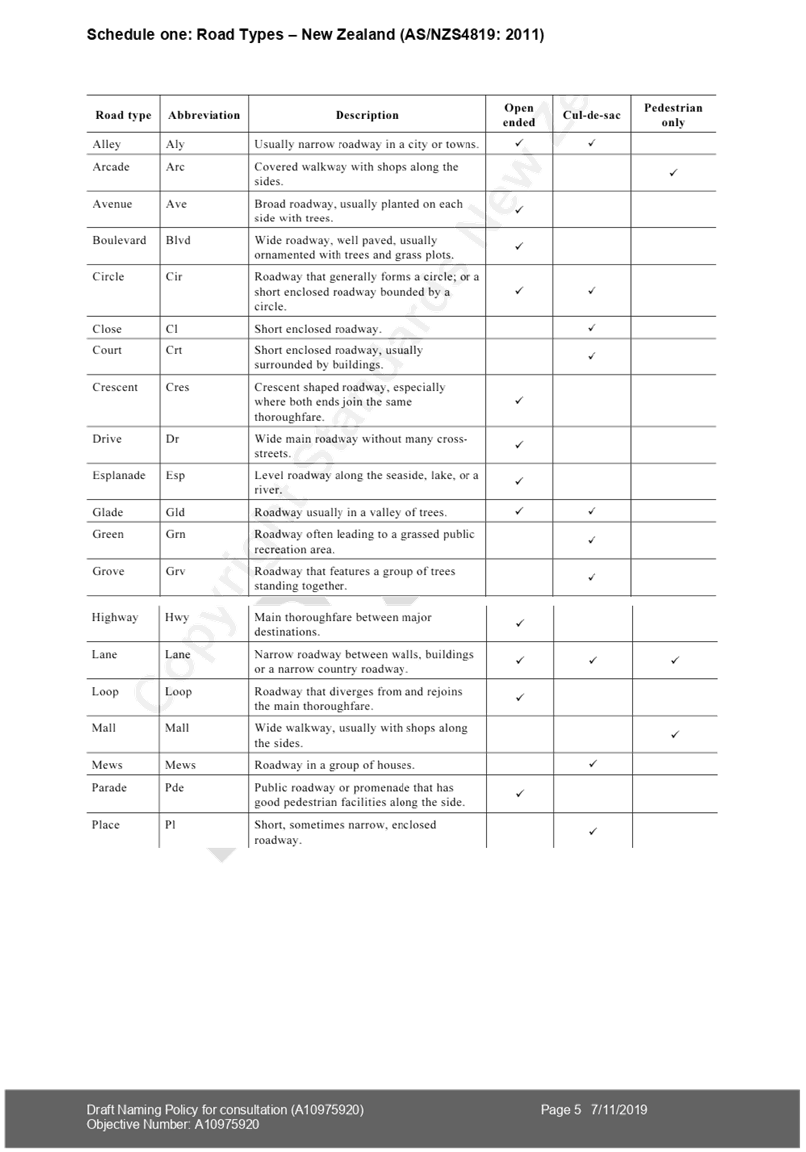
|
Ordinary Council Meeting Agenda
|
5 May 2020
|
Issue one: Support
for policy review
|
Submission
|
Issue
|
|
|
1, 2,
3, 5, 6, 9 , 14, 15, 26, 28, 30, 31, 33, 35, 36, 37, 38, 40, 41, 42, 43, 44,
46, 50, 54, 55, 56, 60, 72, 75, 77, 82, 87, 88, 90, 95, 96
|
Support
policy review
|
This
issue is discussed in paragraphs 13 to 15 and table one of the main report.
|
|
4, 8
,11, 16, 19, 22, 23, 24, 25, 27, 45, 47, 49, 52, 53, 57, 58, 59, 61, 62, 64, 65,
66, 67, 68, 69, 71, 73, 74, 76, 78, 79, 80, 81, 83, 84, 85, 86, 91, 92, 93,
94
|
Do not
support policy review.
|
Issue two: General support for additional policy
purpose encouraging Māori names
|
Submission
|
Issue
|
|
|
1, 2,
7, 9, 35, 37, 40, 44, 77, 90, 95, 96
|
Support
additional purpose and policy intent to encourage more Māori names
|
This
issue is discussed in paragraphs 16 to 18 and table two of the main report
|
|
96
|
Support
and prioritise cultural and historical names with tangata whenua providing
meaning and narrative behind a name
|
1.
| 23, 49, 52, 66, 83,
93 |
Do not
support Māori names as they can be difficult to pronounce or too long
|
1.
| 36, 84,
91, 92 |
Need to
consider tourists in naming decisions
|
|
93
|
English
names are preferable
|
|
84
|
Supports but notes words
should be “pronounceable”
|
1.
| 75 |
Need
places where people can find out name of street
|
Issue
three: Policy on te reo Māori names
|
Submission
|
Issue
|
|
|
96
|
Add an
additional clause to the policy stating support for te reo Māori for
streets and public places.
|
This
issue is discussed in paragraph 19 and table three of the main report
|
Issue
four: General naming criteria
|
Submission
|
Issue
|
|
|
50
|
Support
prioritisation of general naming criteria
|
1. This issue is discussed in
paragraphs 20 to 22 and table four of the main report.
|
|
80
|
Oppose
as only options for future names are Māori or English and Māori
|
|
5, 32
|
Do not
support priority given to Māori names
|
1.
| 10 |
More
English names
|
1.
| 62 |
Significant
and historic places have or retain Māori names, but “normal”
streets and reserves should have “sensible” English names
|
1.
| 10 |
Add
flora and fauna to criteria
|
1.
| 91 |
Use
names of sports people or people who have done outstanding things for
Tauranga
|
Issue
five: Dual naming
|
Submission
|
Issue
|
|
|
2, 14,
15, 28, 38, 42, 43, 75, 95, 96
|
Support
dual naming
|
This
issue is discussed in paragraphs 23 to 26 and tables five to seven of the
main report.
|
|
31, 41
|
Support,
but note potential for confusion
|
1.
| 31, 33, 65 |
Support
dual naming of reserves only / do not support dual naming of streets
|
|
10, 11,
64
|
Do not
support dual naming of streets
|
|
33, 49,
65, 76
|
Do not
support dual naming as potentially confusing
|
|
11, 45,
81
|
Do not
support dual naming
|
|
11, 94
|
English
name should be used first when place is dual named
|
1.
| 2 |
Where
dual naming, Māori name should come first
|
Issue
six: Renaming
|
Submission
|
Issue
|
|
|
7, 12.
40, 44, 46, 50, 87, 91
|
Support
renaming
|
This
issue is discussed in paragraphs 27 to 30 and tables 8 to 12 of the main
report.
|
|
10, 21,
22, 23, 29, 47, 53, 58, 59, 61, 66, 67, 68, 80, 81, 91, 92
|
Do not
support renaming
|
1.
| 61, 68,
76 |
Do not
support renaming as must respect settler history
|
1.
| 5, 36 |
Support
dual naming but do not support renaming
|
1.
| 24, 27, 29, 78 |
Support
Māori for new names only streets and reserves (no renaming)
|
1.
| 31, 40,
87, 88, 95, 96 |
Need to
consider changing streets named in “colonial tribute”
|
1.
| 92 |
Delete
reference to not allowing private application to change street names.
|
1.
| 40, 88.
95, 96 |
Need to
consider changing suburb and other place names named in “colonial
tribute”
|
|
|
4, 13,
17, 20, 33, 34, 51, 69, 70, 81, 84, 89, 93
|
Do not
support street re-naming
|
The draft policy does not propose widespread street name changes.
|
Issue
seven: Additional criteria for street naming
|
Submission
|
Issue
|
Option
|
|
92
|
Delete
reference to “easy to pronounce” and “easy to spell”
|
This issue
is discussed in paragraphs 31 to 35 and tables 13 to 15 of the main report.
|
|
30, 55,
82, 96
|
Easy to
spell and easy to pronounce are subjective and may have the effect of
prioritising English names
|
1.
| 55, 82 |
Character
limit won’t support Māori names or will reinforce Eurocentric
views
|
1.
| 96 |
Change
streets in Pāpāmoa with Californian or Floridian names
|
1.
| 40 |
Less
street names from foreign places
|
1.
| 82 |
Add
Māori words for road types (eg. Te Ara) in the schedule
|
1.
| 40 |
Use
macrons;
Eg Pāpāmoa,
Gate Pā
|
1.
| Staff
submission |
The
road type “way” should be reserved for private roads
|
|
|
36
|
New
public place names will be shorter than Te Papa o Ngā Manu Porotakataka
under the proposed policy
|
The
character limit would apply only to street names.
|
Issue
eight: Consultation on naming
|
Submission
|
Issue
|
|
|
79, 9
|
Consult
on all names, including gifted names
|
2. This issue is discussed at
paragraphs 36 to 39 and tables 16 and 17
|
|
62
|
Nobody
had input into Te Papa o ngā Manu Porotakataka naming decision
|
1.
| 26, 38 |
Do not
consult as will create space for racist discourse
|
1.
| 92 |
Delete
part clause 6.1.1 stating naming or renaming decisions are subject to
consultation
|
|
52
|
Have a public
vote on street renaming
|
3. As noted in issue three below,
there is no intention to change street names. Any proposal to change a street
name would require consultation with affected parties.
|
|
62
|
Nobody
had input into Te Papa o ngā Manu Porotakataka naming decision
|
Councillors
agreed to name the new urban space in Mt Maunganui, Te Papa o ngā Manu
Porotakataka, “subject to consultation”. The name was confirmed
following consultation.
|
Issue
9: Delegation for approval of names
|
Submission
|
Issue
|
Staff response
|
|
92
|
Amend
clause 6.1.1 to state that council and mana whenua are responsible for
naming decisions including sponsorship and naming rights
|
4. This issue is discussed in
paragraphs 40 to 45 and tables 18 and 19 in the main report.
|
|
92
|
Amend
clause 6.1.2 to state that the Chief Executive and mana whenua are
responsible for street name decisions
|
|
Ordinary Council Meeting Agenda
|
5 May 2020
|
11 Discussion
of Late Items
12 Public
Excluded Session
RESOLUTION TO
EXCLUDE THE PUBLIC
|
Recommendations
That the public be excluded from the following parts of
the proceedings of this meeting.
The general subject matter of each matter to be considered
while the public is excluded, the reason for passing this resolution in
relation to each matter, and the specific grounds under section 48 of the
Local Government Official Information and Meetings Act 1987 for the passing
of this resolution are as follows:
|
General subject of each matter to be considered
|
Reason for passing this resolution in relation to
each matter
|
Ground(s) under section 48 for the passing of this
resolution
|
|
10.4 – Western Corridor Wastewater Study – Attachment 4.
|
s7(2)(i) -
the withholding of the information is necessary to enable Council to carry
on, without prejudice or disadvantage, negotiations (including commercial
and industrial negotiations).
|
s48(1)(a)(i) - the public conduct of the relevant
part of the proceedings of the meeting would be likely to result in the
disclosure of information for which good reason for withholding would exist
under section 6 or section 7
|
|
The four well-beings refer to cultural,
economic, environmental and social matters.