|

|
|
AGENDA
Urban Form and Transport Development Committee
Meeting
Tuesday, 21 July 2020
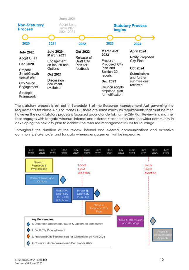
|
|
I hereby give notice that an Urban Form and
Transport Development Committee Meeting will be held on:
|
|
Date:
|
Tuesday, 21 July 2020
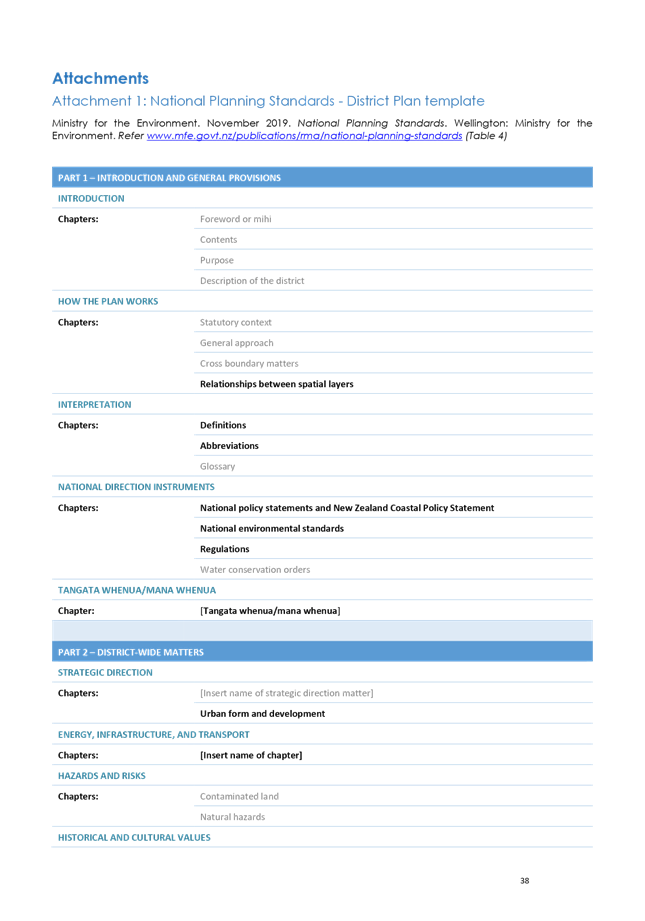
|
|
Time:
|
9.30am
|
|
Location:
|
Tauranga City Council
Council Chambers
91 Willow Street
Tauranga
|
|
Please
note that this meeting will be livestreamed and the recording will be
publicly available on Tauranga City Council's website: www.tauranga.govt.nz.
|
|
Marty Grenfell
Chief Executive
|
Common responsibilities
and delegations
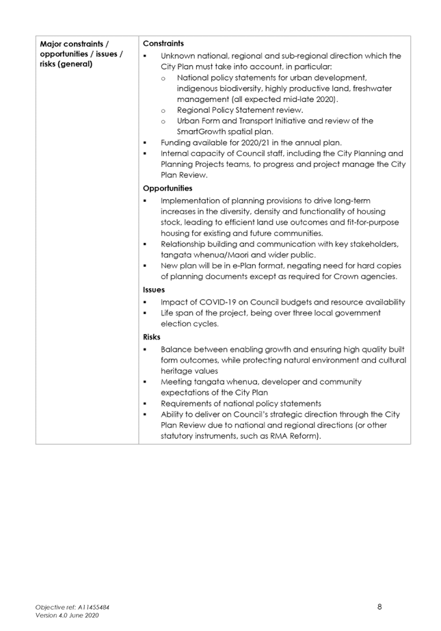
The following common responsibilities and delegations apply
to all standing committees.
Responsibilities of standing committees
·
Establish priorities and guidance on programmes
relevant to the Role and Scope of the committee.
·
Provide guidance to staff on the development of
investment options to inform the Long Term Plan and Annual Plans.
·
Report to Council on matters of strategic
importance.
·
Recommend to Council investment priorities and
lead Council considerations of relevant strategic and high significance
decisions.
·
Provide guidance to staff on levels of service
relevant to the role and scope of the committee.
·
Establish and participate in relevant task
forces and working groups.
·
Engage in dialogue with strategic partners, such
as Smart Growth partners, to ensure alignment of objectives and implementation
of agreed actions.
- Confirmation of committee minutes.
Delegations to standing committees
·
To make recommendations to Council outside of
the delegated responsibility as agreed by Council relevant to the role and
scope of the Committee.
·
To make all decisions necessary to fulfil the
role and scope of the Committee subject to the delegations/limitations imposed.
·
To develop and consider, receive submissions on
and adopt strategies, policies and plans relevant to the role and scope of the
committee, except where these may only be legally adopted by Council.
·
To consider, consult on, hear and make determinations
on relevant strategies, policies and bylaws (including adoption of drafts),
making recommendations to Council on adoption, rescinding and modification,
where these must be legally adopted by Council,
·
To approve relevant submissions to central government,
its agencies and other bodies beyond any specific delegation to any particular
committee.
·
To appoint a non-voting Tangata Whenua
representative to the Committee.
·
Engage external parties as required.
Terms of reference – Urban Form & Transport Development
Committee
Membership
|
Chairperson
|
Cr Larry
Baldock
|
|
Deputy chairperson
|
Cr Heidi
Hughes
|
|
Members
|
Mayor
Tenby Powell
Cr Jako
Abrie
Cr Kelvin
Clout
Cr Bill
Grainger
Cr Andrew
Hollis
Cr Dawn
Kiddie
Cr Steve
Morris
|
|
Non-voting
members
|
Te Pio
Kawe – Tangata Whenua representative
|
|
|
Half
of the members physically present, where the number of members (including
vacancies) is even; and a majority of the members physically
present, where the number of members (including vacancies) is odd
|
|
Meeting
frequency
|
Six weekly
|
Role
·
To develop a vision and pathway for the future
of the City.
·
To ensure that Tauranga’s urban form and
transport system enables, supports and shapes sustainable, vibrant and
interactive communities.
·
To ensure there is sufficient and appropriate
housing supply and choice in existing and new urban areas to meet current and
future needs.
·
To ensure there is a clear and agreed approach
to achieve measurable improvement in transport outcomes in the medium to long
term including transport system safety, predictability of travel times,
accessibility, travel choice, mode shift and improved environmental outcomes.
·
To enable Tauranga’s urban centres to
thrive and provide a sense of place.
·
To enable the development of a vibrant, safe and
successful city centre.
·
To ensure that council and partner investments in
Tauranga’s built environment are economically and environmentally
resilient.
Scope
·
Development of a multi-modal transport
masterplan and associated programmes and network operating plans.
·
Development of the Future Development Strategy,
urban settlement pattern and associated monitoring thereof.
·
Development and oversight of urban centres
strategies, neighbourhood plans and master-plans.
·
Development and oversight of the Compact City
programme in support of higher development densities and the provision of a
greater range of housing options.
·
Leadership of plans for the city centre,
including the Civic Rebuild programme.
·
Development of City Plan changes and related
matters for adoption by Council.
·
Development of strategies, plans and programmes
for the medium to long term delivery of social, environmental, economic,
cultural and resilience outcomes.
Power to act
·
To make all decisions necessary to fulfil the
role and scope of the Committee subject to the limitations imposed.
·
To establish subcommittees, working parties and
forums as required.
·
To appoint a non-voting Tangata Whenua
representative to the Committee.
Power to recommend
·
To Council and/or any standing committee as it
deems appropriate.
6 Confirmation
of Minutes
6.1 Minutes
of the Urban Form and Transport Development Committee Meeting held on 9 June
2020
File
Number: A11583068
Author: Jenny
Teeuwen, Committee Advisor
Authoriser: Robyn
Garrett, Team Leader: Committee Support
|
Recommendations
That the Minutes
of the Urban Form and Transport Development Committee Meeting held on 9 June
2020 be confirmed as a true and correct record.
|
Attachments
1. Minutes
of the Urban Form and Transport Development Committee Meeting held on 9 June
2020
|
 Urban
Form and Transport Development Committee Meeting Minutes Urban
Form and Transport Development Committee Meeting Minutes
|
9 June 2020
|
|

|
|
MINUTES
Urban Form and Transport Development Committee
Meeting
Tuesday, 9 June 2020
|
Order Of Business
1 Apologies. 3
2 Public
Forum.. 3
2.1 Jo
Gravatt and Jacqui Ferrell - Tauranga Community Housing Trust – Opal
Drive Wastewater Catchment 3
3 Acceptance
of Late Items. 4
4 Confidential
Business to be Transferred into the Open. 4
5 Change to
Order of Business. 4
6 Confirmation
of Minutes. 5
6.1 Minutes
of the Urban Form and Transport Development Committee Meeting held on 17 March
2020. 5
7 Declaration
of Conflicts of Interest 5
8 Business. 5
8.1 Growth
& Land Use Projects Progress Report - June 2020. 5
8.2 Eastern
Corridor Wastewater Programme. 6
9 Discussion
of Late Items. 8
10 Public Excluded Session. 8
10.1 Public
Excluded Minutes of the Urban Form and Transport Development
Committee
Meeting held on 17 March 2020
…………………………………………….8
10.2 Willow
Street Precinct - Historic Issues
………………………………..……………...…8
MINUTES OF Tauranga City Council
Urban Form and
Transport Development Committee Meeting
HELD AT THE Tauranga
City Council, Council Chambers, 91 Willow Street, Tauranga
ON Tuesday, 9 June 2020 AT 12pm
PRESENT: Cr
Larry Baldock (Chairperson), Cr Heidi Hughes (Deputy Chairperson), Mayor Tenby
Powell, Cr Jako Abrie, Cr Kelvin Clout, Cr Bill Grainger, Cr Dawn Kiddie, Cr
Andrew Hollis, Cr Steve Morris, Cr John Robson, Cr Tina Salisbury and Te Pio
Kawe (Tangata Whenua Representative)
Cr
Steve Morris and Te Pio Kawe attended via Skype.
IN ATTENDANCE: Marty Grenfell (Chief Executive),
Nic Johansson (General Manager: Infrastructure), Christine Jones (General
Manager: Strategy & Growth), Gareth Wallis (General Manager: Community
Services), Andy Mead (Manager: City & Infrastructure Planning), Claudia
Hellberg (Team Leader: Waters Strategy & Planning), Kate Dawkings (Senior
Planning Engineer -Waters), Coral Hair (Manager: Democracy Services), Robyn
Garrett (Team Leader: Committee Support), and Jenny Teeuwen (Committee Advisor)
Gareth
Wallis (General Manager: Community Services) attended via Skype.
1 Apologies
Apologies for lateness
had been received from Mayor Tenby Powell.
2 Public
Forum
|
2.1 Jo Gravatt and Jacqui Ferrell - Tauranga Community
Housing Trust – Opal Drive Wastewater Catchment
|
|
Key
points
·
The Tauranga Community
Housing Trust (TCHT) managed the transitional housing site at 45 Opal Drive
– Kainga Atawhai, on behalf of Kainga Ora (Housing New Zealand).
·
The site was developed for
transitional housing in partnership between Tauranga City Council (TCC) and
Kainga Ora. There were currently 18 houses on the site.
·
Item 8.2 of this agenda -
Eastern Corridor Wastewater Programme - proposed an upgrade to the pump
station located at 45 Opal Drive which would result in the removal of nine of
the houses.
·
This project had
contributed to housing 61 families over the past two and a half years.
55 of those families had transitioned into long term housing and 85% remained
there. Only 2% returned to emergency housing accommodation or to the
register.
·
TCHT, on behalf of the
whanau, community, and people who would use the housing in the future,
requested that TCC explore all options and/or alternatives.
·
TCHT acknowledged the
contribution of Cr Steve Morris and the previous Cr Leanne Brown to this
project.
·
TCHT requested an
additional recommendation be added to the report “that TCC would take
all possible steps to retain Kainga Atawhai in some form”.
At 12.11pm, Mayor Tenby Powell entered the meeting.
In response to questions
·
The houses on the 45 Opal
Drive site were the property of Kainga Ora.
·
The Kainga Ora lease for
the site expired in two years.
·
TCC staff had been in
communication with Kainga Ora over the proposed upgrade of the pump station
and the future of the site.
·
It had always been clearly
acknowledged that the lease was for a term of 5 years only.
Cr Larry
Baldock thanked Ms Gravatt and Ms Ferrell for their presentation.
|
3 Acceptance
of Late Items
Cr Heidi Hughes requested
an update on the Totara Street safety improvements.
Response from Nic Johansson (General Manager:
Infrastructure)
·
Condolences were expressed to the family and friends of the cyclist who died recently on Totara
Street.
·
Work on stafety improvements for Totora Street
had been ongoing for some time. A report oultlining the design and costs
for a short-term solution would be presented to the Projects, Service and
Operations Committee on 23 June 2020.
·
A positive meeting with representatives from a
number of cycling groups, the New Zealand Transport Authority (NZTA), and Bay
of Plenty Regional Council (BOPRC) had been held recently.
4 Confidential
Business to be Transferred into the Open
|
4.1 Confidential
Business to be Transferred into the Open
|
|
Committee motion
Moved: Cr John Robson
Seconded: Cr
Andrew Hollis
That item 10.2 –
Willow Street Precinct - be transferred into the Open section of this council
meeting
In Favour: Mayor
Tenby Powell, Crs Andrew Hollis and John Robson
Against: Crs
Larry Baldock, Jako Abrie, Kelvin Clout, Bill Grainger, Dawn Kiddie, Steve
Morris and Tina Salisbury
Abstained: Cr
Heidi Hughes
lost 3/7
|
5 Change
to Order of Business
Nil
6 Confirmation
of Minutes
|
6.1 Minutes
of the Urban Form and Transport Development Committee Meeting held on 17
March 2020
|
|
Committee Resolution UR3/20/13
Moved: Cr Kelvin Clout
Seconded: Cr
Andrew Hollis
That the minutes of the Urban Form and
Transport Development Committee meeting held on
17 March 2020 be confirmed as a true and correct record.
Carried
It was requested that the report that had been forwarded to
councillors and the speakers of item 2.1 – Public Forum of the 17 March
2020 Urban Form and Transport Development Committee meeting be made available
to the public.
The report, Query to
staff re closure of Gargan Road, can be viewed on Tauranga City
Council’s website in the Minutes Attachments document for this council
meeting.
|
|
Attachment
1 Query to
staff re closure of Gargan Road
|
7 Declaration
of Conflicts of Interest
Nil
8 Business
|
8.1 Growth
& Land Use Projects Progress Report - June 2020
|
|
Staff Andy
Mead, Manager: City & Infrastructure Planning
Key points
·
Preparation of the application for the Streamlined Planning Process
was underway and needed to be lodged with the Minister for the Environment by
June/July.
·
The Maori Appellate Court had upheld the decision of the Maori
Land Court to dismiss the application by the Te Tumu Kaituna 14 Trust for a
change of status of land (from Maori land to general land) and a Trust order
variation. The Trust had subsequently lodged an appeal and was
considering whether or not to proceed with this.
·
Population and dwelling development trends information
continued to be monitored and reviewed with the revised COVID 19 projections
to ensure projections remain as accurate as possible for the Long Term Plan
(LTP).
·
Community and key stakeholder engagement on the Te Papa Spatial
Plan closed on 19 May 2020. A detailed analysis of the feedback
received was currently being undertaken and it was expected that this would
be presented at the July meeting of the Urban Form and Transport Development
Committee. Engagement would continue over the coming weeks and months.
In response to
questions
·
Funding of $200,000 currently in the draft
Annual Plan would enable further work with the Te Tumu Kaituna 14 Trust to
unlock development in the Te Tumu area.
·
Populations predictions were initially high
level. These were then allocated across the city and this process was
currently underway. Updated population figures would be circulated to
councillors when they became available.
·
The Government was currently looking at a
COVID Recovery Bill that would allow fast tracked resource consenting for
significant infrastructure and housing projects. This could assist with
greenfield projects.
·
A technical study was currently underway in
collaboration with Hamilton City Council to look at minimum dwelling
densities in greenfield areas and how to better achieve a mix of dwelling typologies.
·
30 dwellings per hectare in the Tauriko area
was realistic, however developers were currently at the 20-25 dwellings per
hectare level.
·
Work with the Ministry of Education for the
provision for both primary and secondary schools in the Tauriko West area was
well advanced.
·
A report on engineering investigations in to
transport options in the Welcome Bay and Ohauiti areas would be presented
back to council in the next two to three months.
·
There was no confirmed deadline for the
response to National Policy Statement submissions but these were expected in
the next few weeks.
·
Projected required housing numbers over the
next few years had been revised downwards due to COVID.
·
An update report on Smith’s Farm would
be presented to council over the coming months.
|
|
Committee Resolution UR3/20/14
Moved: Cr Larry Baldock
Seconded: Cr
Andrew Hollis
That the Urban Form and Transport Development Committee receives
the Growth & Land Use Projects Progress Report – June 2020.
Carried
|
|
8.2 Eastern
Corridor Wastewater Programme
|
|
Staff Claudia
Hellberg, Team Leader: Waters Strategy & Planning
Kate
Dawkings, Senior Planning Engineer (Waters)
A copy of the staff presentation for this item can be viewed
on Tauranga City Council’s website in the Minutes Attachments document
for this council meeting.
|
|
Attachments
1 Presentation
- Eastern Corridor Wastewater Programme
|
|
Key points
·
Additional wastewater capacity was required for the Wairakei
and Te Tumu growth areas.
·
The Opal Drive pump station was no longer fit for
purpose. It was currently overloaded and experienced failure during
peak flows.
·
New pump stations to improve network resilience and operation
were proposed on designated Opal Drive and Wairakei sites.
·
The projects were included in the 2018-2028 Long term Plan
(LTP) and associated Infrastructure Strategy.
·
Budgets had escalated due to:
-
additional internal TCC costs, iwi monitoring,
legal and other costs
-
budgeting of 95th percentile cost
estimates
-
revised cost estimates to reflect current
market costs
-
inclusion of additional items such as
groundworks.
·
Development contributions were likely to be
under collected by approximately $15 million to $20 million.
At
1.24pm, Mayor Tenby Powell left the meeting.
In response to questions
·
The most recent overflow event at the Opal
Drive pump station was over a long weekend in 2018 following a heavy rain
event. Overflows went into neighbouring residential properties.
·
Sections of the current pipeline would remain
to be used in emergencies.
·
Confidence ratings were being considered in
budget predictions for the LTP so it was better understood what budget
matters mean.
·
It was recognised that better communication
with the public was required around why costs and budgets change over the
lifetime of the project.
·
The preferred option was chosen following a
comprehensive Multi Criteria Analysis (MCA) process which included
sensitivity testing of criteria weightings and project phases.
·
TCC’s Community Development Team held
the relationships around the lease and formal agreements for the transitional
housing on the Opal Drive site. Communications and briefings had been
held with the lease holders about the proposed upgrade to the pump station on
the site. Other sites for the pump station had been investigated but
none were appropriate for various reasons. Alternative sites for the
nine houses that need to be removed would be investigated as a
priority. This work is linked in with the Mayor’s Taskforce for
Homelessness.
·
Contractors would understand that the P95
percentile is the budget for a worst case scenario and not the actual budget
level.
The recommendations were taken in
parts.
|
|
Committee Resolution UR3/20/15
Moved: Cr Larry Baldock
Seconded: Cr
Kelvin Clout
That the Urban Form and
Transport Development Committee:
(a) Receives the Eastern Corridor Wastewater Programme report.
Carried
|
|
Committee Resolution UR3/20/16
Moved: Cr Steve Morris
Seconded: Cr Tina
Salisbury
That the Urban Form and
Transport Development Committee:
(b) Endorses
the outcomes of the Eastern Corridor Wastewater Programme.
(c) Agrees
to proceed with the implementation of the Opal Drive Rising Main and Opal
Drive Pump Station as a priority to service existing zoned land subject to
budget being available through the 2020/21 Annual Plan and 2021-31 Long Term
Plan.
(d) Agrees
in principle to the delivery of the Eastern Corridor Wastewater Programme subject
to budget being available through the 2021-31 Long Term Plan.
(e) Requests
that TCC endeavours to minimise impacts on the Tauranga Community Housing
Trust and Kainga Ora.
Carried
|
9 Discussion
of Late Items
Nil
10 Public
Excluded Session
RESOLUTION TO EXCLUDE
THE PUBLIC
|
Committee Resolution UR3/20/17
Moved: Cr Kelvin Clout
Seconded: Cr Tina
Salisbury
That the public be
excluded from the following parts of the proceedings of this meeting.
The general subject
matter of each matter to be considered while the public is excluded, the
reason for passing this resolution in relation to each matter, and the
specific grounds under section 48 of the Local Government Official
Information and Meetings Act 1987 for the passing of this resolution are as
follows:
|
General subject of each matter to be
considered
|
Reason for passing this resolution in
relation to each matter
|
Ground(s) under section 48 for the
passing of this resolution
|
|
10.1 - Public Excluded Minutes of the
Urban Form and Transport Development Committee Meeting held on 17 March
2020
|
s7(2)(i) - the withholding of the information is
necessary to enable Council to carry on, without prejudice or disadvantage,
negotiations (including commercial and industrial negotiations)
|
s48(1)(a) - the public conduct of the relevant
part of the proceedings of the meeting would be likely to result in the
disclosure of information for which good reason for withholding would exist
under section 6 or section 7
|
|
10.2 - Willow Street Precinct -
Historic Issues
|
s7(2)(i) - the withholding of the information is
necessary to enable Council to carry on, without prejudice or disadvantage,
negotiations (including commercial and industrial negotiations)
7(2)(g) - the
withholding of the information is necessary to maintain legal professional
privilege
|
s48(1)(a) - the public conduct of the relevant part
of the proceedings of the meeting would be likely to result in the
disclosure of information for which good reason for withholding would exist
under section 6 or section 7
|
In
Favour: Crs Larry Baldock, Heidi
Hughes, Jako Abrie, Kelvin Clout, Bill Grainger, Dawn Kiddie, Steve Morris
and Tina Salisbury
Against: Crs
Andrew Hollis and John Robson
carried 8/2
Carried
|
At
2.10pm, the meeting adjourned.
At
2.25pm, the meeting resumed in Public Excluded.
The meeting closed at 3.15pm.
The minutes of this
meeting to be confirmed at the Urban Form and Transport Development Committee
Meeting held on 21 July 2020.
...................................................
CHAIRPERSON
8 Deputations,
Presentations, Petitions
8.1 Presentation
- Tauranga System Plan - presented by Neil Mason (TSP Project Director), Dean
Kimpton (Chair, TSP Governance Group), Alistair Talbot (Team Leader: Transport
Strategy and Planning), and Craig Richards and Tania Hyde (BECA)
8.2 Presentation
- Tauranga Transport Model - presented by Alistair Talbot (Team Leader:
Transport Strategy and Planning), Bala Arumugham (Principal Transport
Modeller), and Bruce Galloway (Corridor Access Co-ordinator)
9 Business
9.1 Tauranga
City Plan Review Project
File
Number: A11598995
Author: Janine
Speedy, Team Leader: City Planning
Authoriser: Christine
Jones, General Manager: Strategy & Growth
PURPOSE OF THE REPORT
To provide an
overview of the City Plan Review project and seek endorsement of the project
plan.
|
Recommendations
That the Urban Form and Transport Development Committee:
(a) Endorse
the Tauranga City Plan Review – Project Plan (Attachment 1);
(b) Proceed
with Option 4 to undertake a comprehensive review, incorporating the existing
plan changes.
|
Executive Summary
2. The
purpose of the Tauranga City Plan (City Plan) is to assist the Council in
carrying out their functions, in order to achieve the sustainable management
purpose of the Resource Management Act 1991 (RMA). The City Plan covers all
subdivision, land use and development, how and where the city grows and how
natural and physical resources are managed.
3. The
City Plan is a constantly evolving document because it is required to
facilitate future growth demands and respond to changing resource management
issues.
4. Council
is required to publicly notify the next City Plan for formal submissions by
April 2024 to meet Government timeframes under the National Planning Standards,
which came into effect last year and apply to all local authorities. To meet
this timeframe, the City Plan Review project must commence in the 2020/21
financial year. A significant amount of work is required to meet national and
regional direction, and address key issues important to the community, tangata
whenua and stakeholders.
5. The
development of the next Tauranga City Plan will help implement Council’s
blueprint for Tauranga, and is the next step in current planning work such as
UFTI, the Te Papa spatial planning programme, housing choice plan change and
planning for new greenfield development at Te Tumu and Tauriko West.
6. A
project plan, resourcing plan and budget has been prepared. The project plan is
included as Attachment 1. Two external engagement plans have also been
prepared: ‘Communications and Engagement Plan’ and ‘Maori and
Tangata Whenua Communications and Engagement Plan’ to ensure aligned
timeframes and appropriate resourcing and budget is considered for these key
workstreams.
7. Development
of the next City Plan is to occur in six phases. Phases 1 and 2 are intended to
start in July this year with key issues identified and discussed with tangata
whenua, stakeholders, internal Council teams and the wider public. Issues and
options will be presented to councillors and a discussion document prepared for
community engagement in mid-2021. A draft City Plan will be produced for
feedback in 2022 before the formal proposed new City Plan is presented to
Council in late 2023 seeking approval to notify the new plan for submissions by
April 2024.
8. Resourcing
of the City Plan Review project includes five workstreams using internal staff
supplemented by external support. The City Plan Review is a cross-organisation
project, led from the City and Infrastructure Planning teams. The City Plan
Review is included in the current Long Term Plan 2018-2028, however, has a
budget shortfall of $2.0M assuming existing budgeted monies for the City Plan
Review of $1.625M remain available.
9. Depending
on Council direction, and in addition to the budget shortfall identified above,
there is a significant risk that key projects feeding into the plan review are
not currently fully resourced in terms of FTEs and budget, which will need to
be considered through the draft LTP process, alongside the City Plan Review.
10. At
a political governance level, the approach proposed by staff is to report and
seek direction on the City Plan Review project as it progresses through the
Urban Form and Transport Development (UFTD) Committee through a series of
workshops and briefings. Any formal direction would be sought from the Urban
Form and Transport Development Committee. Another option is to formally
establish a City Plan Review Subcommittee of Council to provide governance
oversight.
Background
11. The
last City Plan Review commenced in 2008 and while the issues and challenges for
Tauranga City under the Resource Management Act 1991 are similar, the
legislative requirements, national and regional policy direction are more
recent and place significant additional obligations on local authorities
through their district plans.
12. The
Resource Management Act 1991 requirements and the introduction national
planning standards in April last year which all district plans must follow, as
well as giving effect to national and regional policy statements.
13. The
City Transformation Committee received a Quarterly Update report (DC349) at its
3 December 2018 meeting which endorsed the City Plan programme implementation
findings and resolved to approve a number of important plan changes being
progressed ahead of a full City Plan Review (Housing Choice Plan Change,
Flooding from Intense Rainfall, and Earthworks Plan Changes).
14. There
are a number of interdependencies in delivering the City Plan Review, including
alignment with Western Bay of Plenty District Council’s review of its
district plan, and timing of the review of the Regional Policy Statement by Bay
of Plenty Regional Council, particularly the natural hazards framework and
urban limits growth management.
Project Planning
15. The
project plan outlines the key tasks, timeframes, costs and considerations
associated with the review of the operative Tauranga City Plan. The project
plan is included as Attachment 1.
16. The
review of the City Plan every 10 years is a statutory requirement under the
Resource Management Act. The project plan identifies four key drivers that
require the City Plan to be comprehensively reviewed and amended:
Driver 1 –
Key Challenges and Opportunities
Driver 2 –
National and Regional Planning Issues
Driver 3 –
Alignment with Council strategies
Driver 4 – Plan
Usability and Legal Risk
17. The
project plan sets out six phases for the City Plan Review project, with key
milestones at each stage, including Phase 4 which sees public notification of
the Proposed Tauranga City Plan by April 2024, and for the City Plan to reach
the Council Decisions phase (Phase 6) by December 2025. An overview of
the key stages for the City Plan Review project is set out in Attachment 2. The
date of the plan becoming operative will depend on any appeals process that may
follow, after Council’s decisions on submissions are publicly notified.
18. The
project plan also outlines the proposed governance structure for the City Plan
Review. This includes the proposal to report through the UFTD Committee to
ensure oversight and support at the governance level for the City Plan.
19. Through
workshops and correspondence, councillors will have the opportunity to identify
issues. Staff can then consider those issues and provide options for the UFTD
Committee to provide direction in Phase 1 and 2 of the project.
20. The
project plan identifies the roles and responsibilities of the project
governance and project management to enable the City Plan Review project to be
progressed and delivered.
Strategic / Statutory Context
21. The
City Plan must give effect to current national policy statements. There are
also proposed new requirements through national policy statements for urban
development, freshwater management, highly productive land and indigenous
biodiversity.
22. In
addition, since the last City Plan was adopted, changes have been made at a
regional level, with a new Regional Coastal Environment Plan, Regional Natural
Resources Plan and amendments to the Regional Policy Statement, in particular
introducing more stringent requirements for managing natural hazard risk. The
City Plan must not be inconsistent with regional plans.
23. The
City Plan can also play a role in terms of implementing Council’s own
vision and policies by focusing on those elements that have a resource
management lens.
Options Analysis
24. There
are four options considered for the City Plan Review.
Option 1 – City Plan roll-over
25. This
option is to simply notify the current plan, without any changes made to it and
address issues through the submissions process. However, the operative plan is
no longer fit for purpose and the National Planning Standards require
significant changes, to both format and content. In addition, while parts of
the plan can be rolled-over, all objectives, policies and rules in the plan
will be subject to formal submissions and appeal to the Environment Court. This
option would likely increase the number of appeals and therefore costs to Council
to resolve those appeals.
26. This
option is not considered realistic, or able to be achieved, as it would not
meet the statutory requirements of Schedule 1 of the Resource Management Act
1991 to consult and seek feedback from Ministers of the Crown, local
authorities, tangata whenua and any affected persons in developing the proposed
plan.
Option 2 – Delay City Plan Review
27. Under
this option the review would commence in twelve or 24 months’ time,
however this would require a truncated process to meet the April 2024 deadline
for notification, whereby the new plan is largely dumped on stakeholders,
tangata whenua and the wider public at the stage of notification. The formal
RMA process would then follow.
28. The
work to produce a fit for purpose planning document would be the same, however
there would be limited stakeholder and tangata whenua engagement in developing
the new plan. Statutory obligations on Council to consult with tangata whenua
and consider their feedback may not be met and existing relationships and the
principle of partnership may be adversely impacted. Some cost savings would be
achieved however with less costs around engagement.
Option 3 – Comprehensive Review
29. Every
aspect of the plan is reviewed under this option, using a mix of internal and
external resources. Required technical work and investigations are undertaken
to inform the development of the draft and proposed plan documents.
30. A
draft plan would be released for stakeholder, tangata whenua and public input
and comment, before the formal plan is prepared and notified.
Option 4 – Review incorporating existing plan
changes
31. Prepare
the City Plan by:
· Incorporating
without substantive change parts of the plan that have recently been the
subject of plan changes, or which remain fit for purpose. This would include
the current Housing Choice, Earthworks, and Flooding from Intense Rainfall
Events plan changes; and
· Implementing new
structure planning, intensification and spatial planning projects (Te Tumu,
Tauriko West, TBE extension, Keenan, Ohauiti South (potentially), Mt Maunganui
and Otumoetai- Matua spatial plans etc.); and
· Comprehensive
reviews of identified issues / areas needing review due to national/regional
direction, or of importance/relevance for the city.
32. Option
4 is recommended as it enables national, regional and local issues to be
considered and a ‘fit for purpose’ new plan developed in accordance
with Government’s national planning standards and national policy
statement requirements.
Financial Considerations
33. Resources
required to achieve the project include extensive use of internal staff.
External costs include project management, facilitation of community and
tangata whenua engagement, legal advice and specific technical investigations.
The project plan included as Attachment 1, considers the resourcing and budget
required to progress the City Plan Review project.
34. The
current Long-Term Plan 2018-2028 provides $1.625M over 10 years for the City
Plan Review, however these budgets are not sufficient. Additional funding of
$2.0M will be required, principally through consideration in the draft
Long-Term Plan 2021-2031. For the 2020/21 financial year an additional $356,000
is required to commence the project, which will be funded from within the existing
City and Infrastructure Planning activity budget, including the use of savings
in salary budgets from unfilled vacancies.
35. Costs
for undertaking the statutory part of the City Plan Review (post-April 2024)
are included, however any Environment Court appeal processes are not included
due to the uncertain nature of those costs which depend on whether submitters
agree with Council’s decisions.
36. The
project plan also proposes a 5% contingency in the budget to cover unforeseen
costs in Phases 1 and 2, however there is risk of insufficient budget and
resourcing should the scope increase to include other projects.
37. Identifying
the staff resources and budget required to progress the City Plan Review does
not include key projects that may feed into the City Plan. This includes future
greenfield growth areas such as Keenan Road, Ohauiti South and Tauriko Business
Estate, and future spatial planning of existing urban areas. The scope also
does not include direction to undertake further investigations and studies in
particular areas of the City (for example the Mount industrial area), or
environmental sustainability topics (for example solar panels, use of
greywater, compulsory water tanks). Councillors may direct staff to investigate
such areas, however additional resourcing would be required.
Legal Implications / Risks
38. Section
79 of the RMA requires regional and territorial authorities to commence a
review of their plans at least once every 10 years. The Tauranga City Plan was
made fully operative in September 2013. Therefore, Council is now required to
undertake a review of the City Plan.
39. Central
government introduced the National Planning Standards to make council plans and
policy statements easier to prepare, understand and comply with. The first set
of planning standards came into force on 3 May 2019. The National Planning
Standards require Council to publicly notify the next Tauranga City Plan for
formal submissions by April 2024.
40. To
meet this timeframe, the project is recommended to start in the 2020/21
financial year. A significant amount of work is required to meet national and
regional direction and address key issues important to the community, tangata
whenua and stakeholders.
41. The
project plan includes a risk register, that will be revisited on a regular
basis. The key risks identified are:
(a) Balance
between enabling growth and ensuring high quality built form outcomes;
(b) Meeting
community, tangata whenua and stakeholder expectations;
(c) Unknown
impact of proposed RMA reforms and national policy statements that are
underway, but not yet approved;
(d) Giving
effect to strategic direction, including Urban Form and Transport Initiative
and SmartGrowth;
(e) Timing
of Bay of Plenty Regional Policy Statement review and potential challenges
implementing some of the existing provisions of the RPS;
(f) Project
scope increasing and resourcing being insufficient.
Consultation / Engagement
42. A
Communications and Engagement Plan has been prepared as part of the project
planning and is one of the five project workstreams. The engagement approach is
to closely match the phases on the City Plan Review, ensuring that stakeholders
and the community have input from the very first phase and throughout. A
stakeholder mapping exercise was undertaken to understand those who will be
interested and the range of channels that will be used to keep them informed
and gain input at each phase. A synopsis of the Communications and Engagement
Plan is included as Attachment 3.
43. The
Tangata Whenua and Maori Engagement Plan was also prepared as part of the
project planning as a key input to the Cultural/Tangata Whenua workstream. The
engagement plan identifies more than 40 tangata whenua and Maori groups and
organisations that may participate in the City Plan Review. Each of these
groups will require different levels of engagement which has been identified
for each phase. A synopsis of the Tangata Whenua and Maori Engagement Plan is
included as Attachment 4.
44. These
engagement plans also identify resourcing and budget required to undertake
these workstreams which have been included in the project plan for the City
Plan Review project.
Significance
45. The
City Plan Review is of high significance as it affects a wide range of people,
and there is the potential for large consequences for the city.
Next Steps
46. Commence
the Tauranga City Plan Review project following endorsement of the project plan
by the Urban Form and Transport Development Committee.
47. Budget
and resources set out in the project plan will be considered through the next
Long-Term Plan.
Attachments
1. Tauranga City
Plan Review - Project Plan - A11624901 ⇩ 
2. Key Phases of the
City Plan Review project - A11594509 ⇩ 
3. Synopsis of
Communications and Engagement Plan for City Plan Review - A11624899 ⇩
4. Synopsis of Maori
and Tangata Whenua Engagement Plan for City Plan Review - A11624902 ⇩
|
Urban Form and
Transport Development Committee Meeting Agenda
|
21 July 2020
|


|
Urban Form and Transport Development
Committee Meeting Agenda
|
21 July 2020
|

|
Urban Form and
Transport Development Committee Meeting Agenda
|
21 July 2020
|

|
Urban Form and
Transport Development Committee Meeting Agenda
|
21 July 2020
|


9.2 Te
Papa Spatial Framework and Housing Choice Plan Change - Shape your City
Engagement Summary and Response
File
Number: A11621513
Author: Janine
Speedy, Team Leader: City Planning
Authoriser: Christine
Jones, General Manager: Strategy & Growth
PURPOSE OF THE REPORT
To report to
Council feedback received through the shape your city engagement for the Te
Papa Spatial Framework and Plan Change 26 – Housing Choice; and to seek
direction on the Te Papa Housing Overlay geographic extent and the built form
options for Plan Change 26 – Housing Choice.
|
Recommendations
That the Urban Form and Transport Development Committee:
(a) Receive Shape Your City
engagement reports (Attachment 1 and Attachment 2);
(b) Endorse Option 1 on the Te
Papa Housing Overlay geographic extent to be proposed through the Te Papa
Spatial Framework and Plan Change 26 – Housing Choice;
(c) Endorse Option 4 on the
built form options to be proposed through Plan Change 26 – Housing
Choice.
|
Executive Summary
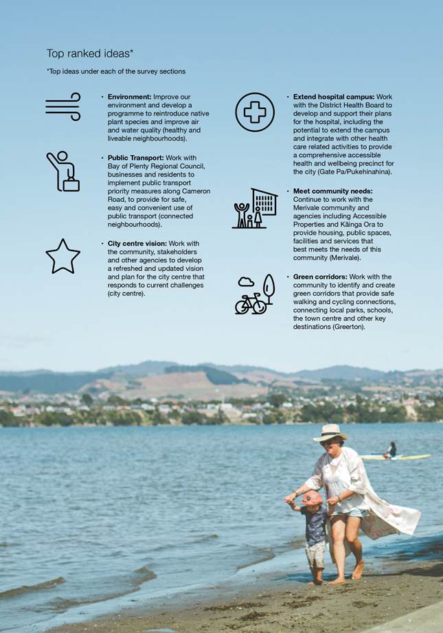
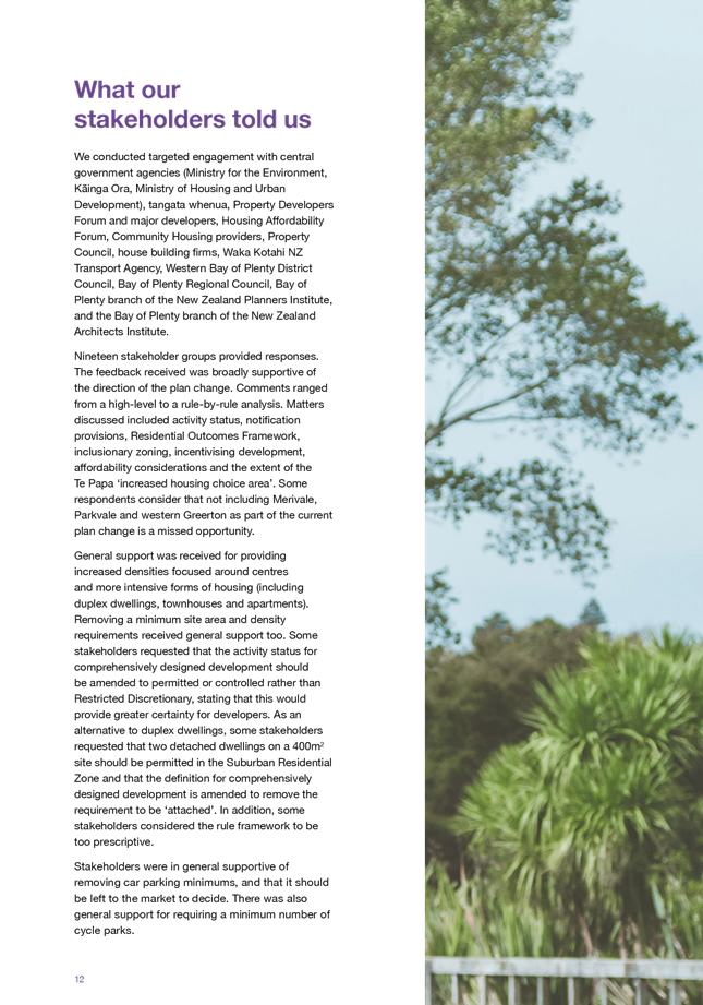
2. Engagement with the
community and stakeholders on the Te Papa Spatial Framework and Plan Change
– Housing Choice was undertaken from 7 April 2020 to 19 May 2020.
3. Council asked the
community and stakeholders for their feedback on proposed ideas, potential
projects and initiatives to support growth in the Te Papa peninsula and on
details of the draft plan change for housing choice through the shape your city
engagement.
4. Over this time, a
range of feedback was received. The feedback received from the community and
stakeholders was generally supportive and that the Te Papa Spatial Framework
and Plan Change 26 – Housing Choice are progressing in the right
direction. Community feedback shows overall support for the ideas, projects,
initiatives and rules proposed. An engagement report on the feedback received has
been prepared and included as Attachment 1 for the Te Papa Spatial Framework
and Attachment 2 for Plan Change 26 – Housing Choice. There were two key
themes received through feedback from stakeholders where direction is sought. A
summary engagement has also been prepared on the ‘Shape Your City’
engagement which is included as Attachment 3.
5. The first key theme
was the extent of the Te Papa Housing Overlay to enable increased height (4-6
storeys) through Plan Change 26 – Housing Choice and identified in the Te
Papa Spatial Framework. In particular, feedback suggested that Merivale
should be included within the Te Papa Housing Overlay for the plan change and
housing choice area for the Te Papa Spatial Framework.
6. The second key
theme was to provide for detached dwellings on smaller sites. This is in
additional to duplex dwellings as proposed through Plan Change 26 –
Housing Choice.
BACKGROUND
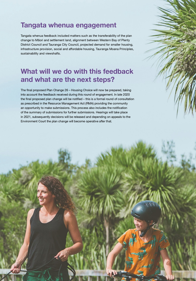
7. Engagement was
undertaken from 7 April until 19 May 2020 with the community and key
stakeholders on the Te Papa Spatial Framework and Plan Change 26 –
Housing Choice. A summary of how the engagement occurred over this period was
provided to the Urban Form and Transport Development Committee on 9 June 2020.
8. Technical work for
Plan Change 26 – Housing Choice is continuing in preparation for seeking
notification on Plan Change 26 – Housing Choice and to seek adoption of
the Te Papa Spatial Framework. This includes working through the requirements
for natural hazards to ensure that Plan Change – 26 – Housing Choice
gives effect to the Bay of Plenty Regional Policy Statement. There has been
correspondence and meetings with Bay of Plenty Regional Council (BoPRC) staff
over the last 18 months to ensure there is alignment on how the plan change
gives effect to the natural hazard policies. A city-wide risk assessment has
been undertaken and Tauranga City Council staff are proposing to apply a
spatial extent to remove areas of the city that are subject to high risk from
natural hazards. This includes large areas of the coastal strip from Arataki to
Papamoa. Staff are currently seeking confirmation from BoPRC that this approach
gives effect to the natural hazard requirements.
9. At the Urban Form
and Transport Development Committee meeting on 9 June 2020, the City and Infrastructure
Planning team provided an update on plan changes. This included an update on
using the Streamlined Planning Process for Plan Change 26 – Housing
Choice. The Streamlined Planning Process would enable Plan Change 26 –
Housing Choice to be operative within 12-15months of notification. Staff have
met with Ministry for the Environment to discuss the information requirements
and timeframes to progress with the Streamlined Planning Process. Due to
central Government elections, staff have been advised that it is extremely
unlikely that we are able to utilise the Streamlined Planning Process, if
notification is sought before the end of the year. While engagement is still
underway at a Ministerial level, it is likely that Plan Change 26 –
Housing Choice will follow the standard Schedule 1 Resource Management Act
process, which means that the plan change will be subject to Environment Court
appeals.
Te Papa Spatial
Framework – Te Papa Housing Overlay Geographic Extent
10. The ‘Shape Your
City’ engagement proposed a housing choice area through the Te Papa Plan
Outcomes and Ideas discussion document, that identified areas to enable
increased height and density through terraced housing and apartments.
11. Plan Change 26 – Housing
Choice proposes to apply the Te Papa Housing Overlay to properties identified
in the housing choice area. The Te Papa Housing Overlay is a rule framework
that enables four to six storeys through a resource consent process, so that
each application can be assessed on a site-by-site basis to ensure good
outcomes are achieved for both future residents and neighbours. These will be
non-notified providing that all the standards can be met. An example of a
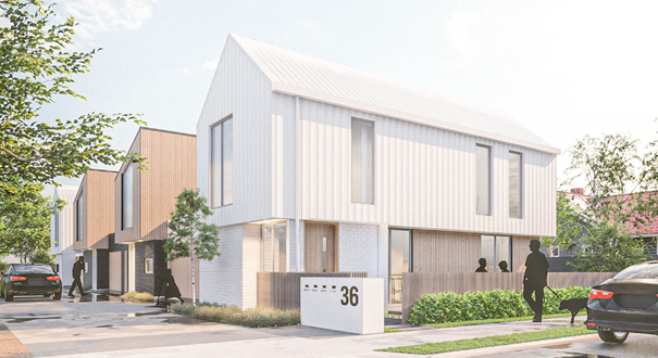
four-storey apartment that would be enabled through the Te Papa Housing Overlay
is illustrated below in image 1.

Image
1 – Example of four storey apartment that would be enabled through the Te
Papa Housing Overlay.
12. In identifying areas along the
Te Papa peninsula that are appropriate to provide for additional height of four
to six storeys, staff prepared a suitability analysis in the form of a heat map
of showing appropriate locations for inclusion. This analysis measured the
proximity to services such as public transport, commercial centres, open space
and schools. These maps show that Merivale is not well located to centres,
public transport and has limited connections to amenities. The suitability
mapping prepared for the Te Papa peninsula are provided below in Image 2.
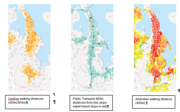
Image 2
– Suitability mapping of Te Papa Peninsula
13. Merivale also faces significant
socio-economic challenges. It is among the most deprived 10% of New Zealand
communities, with low levels of income, employment and educational attainment
and it has some of the highest crime rates in Tauranga.
14. Accessible Properties have
significant landholdings in the Gate Pa / Pukehinahina and Merivale area. There
are opportunities for wider central government partnership, in the Gate Pa area
as it is relatively well placed in terms of public transport and amenity to
support growth in the near term, through the proposed Te Papa programme and Plan
Change 26 – Housing Choice.
15. Having regard to the above, it
is considered an appropriate response to confirm funding and work with
programme partners to put in place a project to the above challenges in
Merivale before allowing higher densities that would currently be unsupported
by the necessary physical and social infrastructure.
16. As Merivale is zoned Suburban
Residential, Plan Change 26 – Housing Choice still applies where it is
proposed to enable duplexes and comprehensively designed development. The
proposed built form to be enabled is discussed further below.
17. Through the ‘Shape Your
City’ engagement, a number of stakeholders from the development community
have sought the inclusion of Merivale in the housing choice area for the Te
Papa Spatial Framework and Te Papa Housing Overlay for Plan Change 26 –
Housing Choice to enable increased height and densities of four to six storeys.
18. Since receiving this feedback,
staff have held follow up workshops with key stakeholders to discuss their
concerns.
19. It is also noted that feedback
was received from members of the community in opposition to higher densities,
noting the existing challenges the community faces.
Plan Change 26
– Built Form Outcomes
20. Through the ‘Shape Your
City’ engagement, Council sought feedback from the community and
stakeholders on the draft provisions.
21. The Tauranga City Plan (City
Plan) currently provides for one independent dwelling unit per 325m2
of nett site area in the Suburban Residential Zone. The Suburban Residential
Zone covers most of the City and is considered to be a ‘low’
density zone in the City Plan. This minimum lot size (325m2 per
dwelling) is one of the lowest in New Zealand for the equivalent low density
general residential zone.
22. Engagement on draft provisions
for Plan Change 26 – Housing Choice proposed one duplex dwelling (two
attached units) on a 400m2 site as a permitted activity. Therefore,
no resource consent is required if all standards can be met. The intention of
providing for a duplex as a permitted activity on a 400m2 site is
when viewed from the street or neighbouring sites, a duplex dwelling appears as
one large dwelling. An example of a duplex is illustrated below in image 3.
Image 3 – Example of duplex dwelling
23. Three
or more units on a site, are provided for as a comprehensively designed
development was also proposed through the engagement. The
comprehensively designed development requires resource consent so that each
application can be assessed on a site-by-site basis to ensure good outcomes are
achieved for both future residents and neighbours. These will be non-notified
providing that all the standards can be met. An example of a comprehensively
designed development is illustrated below in image 4.
Image
4 – Example of comprehensively designed development on a 720m2 site
24. For both duplexes and
comprehensively designed development, Plan Change 26 – Housing Choice
proposes to retain the building envelope that currently applies (including
height, setback and overshadowing) in the Suburban Residential Zone. However,
Plan Change 26 – Housing Choice proposes that the number of dwellings
that can be established within the permitted building envelope is increased.
This will maintain community expectations around the bulk, scale and location
of buildings whilst enabling greater housing choice to meet the needs of the
community and changing demographics.
25. Providing for attached
dwellings as part of a duplex or comprehensively designed development will generally
result in better design outcomes as we move towards smaller sites. Whereas with
individual dwellings on small sites it may be challenging to achieve good design
outcomes and to use the site efficiently without having unusable or wasted
space. These challenges were identified through the architectural testing.
26. Under the proposed planning
framework, it is possible to establish detached dwellings with a density of
less than 325m2 of nett site area through a resource consent process
as a discretionary activity. Detached dwellings with a density of 325m2 or
more would remain as a permitted activity.
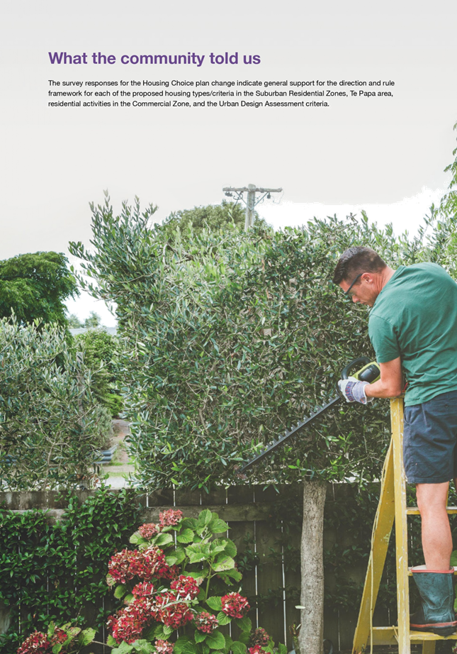
27. Despite general community
support for the approach to duplexes and comprehensively designed development
in the Suburban Residential Zone, six stakeholders from the development
community and social housing sector sought amendments to the proposed
provisions to provide for detached dwellings as a permitted activity (i.e. 1
unit/200m2) without needing a resource consent.
STRATEGIC / STATUTORY CONTEXT
28. The Te Papa Spatial Framework
and Plan Change 26 – Housing Choice deliver on the outcomes sought by the
Urban Form and Transport Initiative, along with the draft Future Development
Strategy and Tauranga Urban Strategy.
29. These projects have also been
developed to align with the current central Government direction on the
proposed National Policy Statement for Urban Development (NPS-UD), which
requires higher densities in close proximity to centres and public
transport. Through the preparation of the Te Papa Spatial Framework and
Plan Change 26 – Housing Choice, staff have applied those principles, but
have refined and made recommendations based on local conditions. It is expected
the approved NPS-UD will be released by central Government in the next month.
OPTIONS ANALYSIS
30. An
options analysis has been undertaken for the two issues outlined above.
Te Papa Spatial Framework – Te Papa Housing Overlay
Geographic Extent
31. Option
1 – Recommended
Identify Merivale for future
inclusion in the housing choice area of the Te Papa Spatial Framework (to be
considered for increased height of four to six storeys through the City Plan
Review), with further programme development and required investment to be
identified in the meantime.
|
Advantages
|
Disadvantages
|
|
· An agreed way forward with stakeholders (and
potential programme partners) can be developed, to ensure a joined-up
approach and support investment.
· Detailed technical assessments can be
undertaken to consider future urban form implications.
· Will provide time to undertake engagement with
the community and key agencies and take them on the journey while responding
to local challenges.
· Time to consider appropriate funding to
support the community for the future and increase suitable in terms of access
to amenities, public transport and commercial centres.
· Plan change 26 would still provide significant
redevelopment potential in the Merivale area through the duplex and
comprehensively designed development provisions.
|
· Larger sites could be under-utilised in the
short term; however, this can be managed through proactive partnering and
communication with key stakeholders.
· Doesn’t align with key stakeholder
aspirations; however, it is noted that key stakeholders are still very early
in their planning phases.
|
32. There
is risk with Option 1 that if the inclusion of Merivale is submitted on through
Plan Change 26 – Housing Choice, this will be considered by the hearings
panel and could be approved with limited wider community consultation.
33. Option
2 - Include Merivale in the housing choice area of the Te Papa Spatial
Framework and Te Papa Housing Overlay for Plan Change 26 - Housing Choice.
|
Advantages
|
Disadvantages
|
|
· Decision would align with key stakeholder
views.
· Additional height (four to six storeys) is
enabled within the next 2 years.
|
· Currently not supported by adequate
infrastructure to support higher densities associated with apartments of four
to six storeys, e.g. doesn’t score highly in the suitability assessment
and no funding allocated in the LTP to address short falls (currently looking
to address through IBC and LTP).
· Not within centres or high frequency public
transport / rapid transit catchments.
· When overlaid with existing amenities (public
transport, centres, schools and parks) it scores lower than other areas.
· Has some of the highest crime and violence in
all of NZ and it might not be ready for change without significant
investment.
· Need for additional community engagement.
· Infrastructure modelling hasn’t fully
considered intensification in this area for four to six and further work will
be required to determine capacity.
|
34. The
risk with Option 2 is there will be negative social outcomes and that the
community lose confidence that additional height and density in the form of
apartment buildings is enabled in areas that are not well connected and require
further investigation and funding to support growth.
35. Staff
recommend Option 1 to identify Merivale for future inclusion in the
housing choice area of the Te Papa Spatial Framework to be considered through
the City Plan Review.
Plan Change 26 (Housing Choice) – Built Form
Outcomes
36. Option
1 - Provides for duplex dwellings on 400m2 site as a permitted
activity (without requiring resource consent) and two detached dwellings on the
same site would require discretionary resource consent if they don’t
comply with the current 325m2 minimum site size requirements.
37. Three
or more dwellings on a site, are defined as a comprehensively designed
development and would require consent for restricted discretionary activity.
|
Advantages
|
Disadvantages
|
|
· Encourages alternative typologies such as
duplexes and terraced/town houses.
· Ensures that the outcomes are appropriate for
a permitted activity within the Suburban Residential Zone.
· Detached are enabled on sites of 325m2
and duplex on 400m2 can occur as permitted activity.
· Provides for housing choice.
· Similar approach to what other Councils are
doing around New Zealand.
· Detached dwellings on a site smaller than 325m2
could be achieved through a discretionary resource consent, this would enable
all matters to be considered.
· Community feedback is in general support of
this approach.
|
· Does not align with feedback from some key
stakeholders regarding detached dwellings on smaller sites.
· Detached dwellings on small sites would
require resource consent for a discretionary activity, this has costs and
uncertainty associated with it.
· Tiny houses on a smaller site would remain a
discretionary activity unless there are three or more and they would then be
considered through a comprehensively designed development.
|
38. Option
2 - Allow for two dwellings on a 400m2 site (either attached or
detached) as a permitted activity, but with additional performance standards
that need to be met to ensure quality outcomes are still achieved for two units
on a site. These would likely be around setbacks and overshadowing between
buildings.
|
Advantages
|
Disadvantages
|
|
· Addresses feedback from six stakeholders
regarding detached dwellings on smaller sites.
· Provides for housing choice.
· No resource consent required and therefore no
cost or uncertainty associated with obtaining a resource consent.
· Provides for tiny houses on smaller lots as a
permitted activity.
|
· May result in low quality design outcomes so
that fire rating requirements in the Building Act can be complied with (i.e.
long blank walls without windows)
· Inefficient use of land may lead to unusable
or wasted space.
· Likely to set precedent for vacant lots down
to 200m2 which would undermine the existing ‘low’
density zone.
· Site design may compromise onsite amenity and
living conditions.
· Additional rules to prevent poor outcomes
creates more complexity in achieving permitted activity status.
· Approach has not been tested with the
community.
|
39. Option
3 - Provide for two or more dwellings (detached or attached) on a site as a
restricted discretionary activity.
|
Advantages
|
Disadvantages
|
|
· Ability to assess every application to ensure
that the outcomes are appropriate.
· Restricted discretionary activity status
provides greater certainty for applicants around what will be assessed rather
than a discretionary activity status.
|
· Does not address feedback from stakeholders
regarding detached dwellings on smaller sites as a permitted activity.
· This approach is inconsistent with the
messaging that we have been giving to stakeholders to date.
· Duplexes would no longer be permitted as
currently proposed.
· Cost to applicants of obtaining consent.
· Approach has not been tested with the
community.
|
40. Option
4 – Recommended
Provide for duplex dwellings on
400m2 site as a permitted activity (without requiring resource
consent) and for two or more detached dwellings or three or more attached
dwellings on a site as a comprehensively designed development. The
comprehensively designed development would require consent for restricted
discretionary activity but with additional performance standards that need to
be met to ensure quality outcomes are still achieved for multiple units on a
site. These would likely be around setbacks and overshadowing between
buildings.
|
Advantages
|
Disadvantages
|
|
· Encourages alternative typologies such as
duplexes and terraced/town houses, but also retains consideration of detached
dwellings on sites less than 325m2.
· Ensures that the outcomes are appropriate for
a permitted activity within the Suburban Residential Zone.
· Detached are enabled on sites of 325m2
and duplex on 400m2 can occur as permitted activity.
· Provides for housing choice.
· Two or more detached dwellings on a site could
be achieved through a comprehensively designed development and provides the
ability to assess every application to ensure that the outcomes are
appropriate.
· Addresses feedback from stakeholders to some
extent by providing easier pathway for dwellings such as tiny houses on
smaller lots as a restricted discretionary activity rather than discretionary
where anything can be considered.
|
· May result in low quality design outcomes so
that fire rating requirements in the Building Act can be complied with (i.e.
long blank walls without windows) unless additional rules are included.
· Additional rules to prevent poor outcomes
creates more complexity in achieving development standards and
non-notification provisions.
· Approach has not been tested with the
community.
|
41. It
is recommended to proceed with Option 4 as it enables greater
housing choice and seeks to retain the bulk and location of dwellings
consistent with the Suburban Residential Zone.
Financial Considerations
42. There no financial
considerations associated with this report.
Legal Implications / Risks
43. There
are no legal considerations associated with this report. Draft provisions and
the s.32 report will be legally reviewed before seeking notification of Plan
Change 26 – Housing Choice.
consultation / engagement
44. As set out above, engagement occurred
over April and May on the Te Papa Spatial Framework and Plan Change 26 –
Housing Choice. A summary of how the engagement occurred over this period was
provided to the Urban Form and Transport Development Committee on 9 June 2020.
45. Engagement reports on the
feedback received on the Te Papa Spatial Framework and Plan Change 26 –
Housing Choice is included in Attachment 1 and Attachment 2 respectively.
46. Formal consultation on Plan
Change 26 – Housing Choice will be undertaken in accordance with Schedule
1 of the Resource Management Act 1991.
significance
47. These projects are of medium
significance as Plan Change 26 – Housing Choice relates to changes to the
City Plan that affects:
· large areas of the
Tauranga community, being the Suburban Residential, City Living and Commercial
zones; and
· a subgroup within
the Tauranga community and the Te Papa Spatial Framework area from the central
business district to Greerton.
48. These projects also flow from
previous direction provided by Council.
NEXT STEPS
49. The Te Papa discussion
document used for engagement will form the basis of the Te Papa Spatial
Framework, which will be presented to Council in the second half of 2020.
Community feedback will be used, alongside technical information, to determine
priorities for the implementation plan and to identify areas which require
further work.
50. The documents required to
notify Plan Change 26 – Housing Choice will now be finalised for
notification, taking into account the feedback received during this round of
engagement and direction sought through this report. A report will be presented
to Council seeking notification of Plan Change 26 – Housing Choice in
accordance with Schedule 1 of the Resource Management Act 1991 in the second
half of 2020.
Attachments
1. Te Papa Community
Engagement Outcomes - April/May 2020 - A11622857 ⇩ 
2. Plan Change 26 -
Housing Choice - Community and Stakeholder Engagement Report and Appendices -
July 2020 - A11615391 ⇩
3. Shape your City -
Summary Engagement Report - July 2020 - A11619058 ⇩
|
Urban Form and
Transport Development Committee Meeting Agenda
|
21 July 2020
|


|
Urban Form and Transport Development
Committee Meeting Agenda
|
21 July 2020
|


|
Urban Form and Transport Development
Committee Meeting Agenda
|
21 July 2020
|


9.3 Transport
& Water Strategy and Planning Projects Progress Report - July 2020
File
Number: A11503079
Author: Andy
Mead, Manager: City & Infrastructure Planning
Authoriser: Christine
Jones, General Manager: Strategy & Growth
PURPOSE OF THE REPORT
The purpose of
this report is to provide the Committee with an update on the current progress,
next steps and any identified risks with the current Transport & Waters
Strategy and Planning projects.
|
Recommendations
That the Urban Form and Transport Development Committee:
(a) Receive the Transport &
Water Strategy and Planning Progress Report – July 2020.
|
Executive Summary
2. Tauranga continues
to experience rapid urban development pressure and growth which creates demand
for transport and waters infrastructure. This growth is likely to slow in
the short-term as the result of Covid-19 but is expected to recover in the
medium to long-term.
3. The attached report
outlines the progress being made in relation to projects necessary to provide
for this continued growth. This information is also regularly reported to
the SmartGrowth partners and the SmartGrowth Forums.
4. Of specific note
are:
(a) Progress on the Nanako Stream
stormwater consent to enable development of the Kennedy Road area in Pyes Pa
West (The Lakes). This consent is now being lodged with BOPRC.
(b) On-going discussions with Waka
Kotahi (NZTA) in respect of options and design elements for the TNL project and
the Tauriko business case.
(c) The completion of the UFTI
project.
(d) Progress on the TSP project as
detailed in a separate presentation at this meeting.
(e) The separate presentation on the
new suite of transport models at this meeting.
Strategic / Statutory Context
5. The growth-related
waters and transportation projects are framed under the strategic direction of
SmartGrowth and UFTI, the draft Future Development Strategy, the 30-year Infrastructure
Strategies and the Long-Term Plan.
Options Analysis
6. There are no
options; this report is for information only.
Significance
7. While growth is a
significant issue for Tauranga City, this report does not require any decisions
and is not significant in itself.
Next Steps
8. Council continue to
progress the projects and works identified in this update report.
Attachments
1. Appendix A -
Quarterly Update - Transport Projects - July 2020 - A11575096 ⇩ 
2. Appendix B -
Quarterly Update - Waters Strategy Planning Projects - July 2020 - A11502107 ⇩
|
Urban Form and
Transport Development Committee Meeting Agenda
|
21 July 2020
|
|
Project
Description
|
Current Update (key matters)
|
Next Steps and Identified Risks
|
|
Planning Projects
|
|
Urban Form and Transport Initiative (UFTI)
The purpose of UFTI is to identify an integrated
strategic approach for the development of the Western Bay of Plenty’s
urban form and transport system. This includes delivering an integrated,
strategic, shared funding programme with immediate and future priorities and
investment opportunities in urban form, transport and other connected areas
such as education and health.
|
· The Final Report for UFTI was endorsed by Tauranga
City Council and the SmartGrowth partner Councils at the combined SmartGrowth
Leadership Group meeting on 1 July 2020.
· The Government partners to UFTI are now progressing
their own decision-making on the Final UFTI report. Waka Kotahi NZ Transport
Agency are programmed to make their decision at their Board meeting in August
2020.
|
· Following decision-making by all Project partners
the focus moves to progressing delivery of the Actions identified in the UFTI
programme.
· SmartGrowth’s existing governance model, now
adjusted to bring in Ministerial representation, is the lead governance
entity for overseeing delivery of UFTI. The SmartGrowth model is supported by
a range of pre-existing and proposed coordinating committees and groups (e.g.
Regional Transport Committee; Regional Passenger Transport Committee;
Priority One) to enable this.
· From a transport perspective the Western Bay of
Plenty Transport System Plan is a key process to progress the transport
direction provided by UFTI.
· From a land use planning perspective the development
of the Western Bay of Plenty Spatial Plan is the process to progress the
settlement pattern direction provided by UFTI.
|
|
Western Bay of Plenty Transport System Plan (TSP)
The purpose of the TSP is to identify the preferred
strategic form of the City’s key transport network to deliver
appropriate levels of service for all transport modes. As part of this, there
will be a specific focus on long-term options and solutions for key pinch
points in the network such as the Hewletts Road area.
|
· Presentation of the TSP project to be provided as
part of this UFTD Committee meeting.
· The TSP project was endorsed by Tauranga City
Council in September 2019.
· Partnership based governance, management and
technical project teams have been established to deliver the TSP.
· The project partners include Waka Kotahi NZ
Transport Agency, Bay of Plenty Regional Council, Western Bay of Plenty
District Council, Port of Tauranga and KiwiRail. Iwi and Priority One
representation is in the process of being confirmed.
· A consultant team has been appointed to deliver the
first stage of the TSP project, which is the development of a 30-year
‘System Operating Framework’ (SOF).
· The SOF is a collaborative, evidence-based process
which identifies mode conflicts and priorities, gaps in modal level of
service, and can test options to respond to these gaps at a corridor and
route level.
· Waka Kotahi NZ Transport Agency have confirmed Funding
Assistance Rate subsidy (65%) for SOF stage of the TSP project. Further
decisions on FAR subsidy will be made by the NZTA based on the findings of
the SOF.
|
Next
steps for the project include:
· Confirming primary and secondary routes for each
mode (e.g. freight; public transport; cycling, general traffic).
· Analysing the modal operating gaps at a corridor and
route level.
· Testing options to respond to modal operating gaps.
· Developing the programme of activities (i.e. that
respond to operating gaps) to support the Long-Term Plan/Regional Land
Transport Plan/National Land Transport Plan processes.
It
is important for the TSP to demonstrate alignment to the strategic direction
for land use and transport identified by UFTI. A process has been established
by the project partners to resolve issues should the TSP, through further and
more detailed corridor and route level analysis, identify issues that impact
on the direction provided by UFTI.
|
|
Regional Mode Shift Plan
|
· NZTA has identified the need to develop a Mode Shift
Plan (MSP) for public transport and active modes for the Bay of Plenty region
by mid-2020. The development of the MSP is being co-ordinated by the NZTA and
the Bay of Plenty Regional Council with input from local Councils.
· The requirement for an MSP also applies to other
high growth areas like Auckland (completed), Hamilton, Wellington,
Christchurch and Queenstown (all under-development).
· The MSP will document and reflect key existing
initiatives already underway or relevant to mode shift e.g. UFTI, TSP, Te
Papa Spatial Plan, Cycle Plan.
· It is understood that the content of the MSP will be
taken account in future investment decision-making by the Transport Agency
(e.g. an activity included in the MSP has the potential to be prioritised
above other activities). The framework to outline this is likely to be
released as part of the next draft Government Policy Statement on Land
Transport and possibly through the NZTA’s Investment Assessment Framework
(which the NZTA uses to gives effect to the Government Policy Statement).
|
· Continue working with the NZTA and BoPRC to support
the continued development of the MSP.
· Confirm with NZTA the extent MSP will be used to
inform future investment decision-making processes.
· Provide a report to UFTD on the MSP, its content and
the role it will perform for NZTA in any investment decision making
processes.
|
|
IDC (Infrastructure
Development Code) Transport Provisions
Updating the transport provisions within the IDC to
ensure future street designs can facilitate medium density developments and
achieve improved street design for all people using streets.
|
· The Tauranga Streetscape design guide was endorsed
by the City Transformation Committee in December 2018.
· Work continues on developing the Streetscape design
tool that will support the delivery of the Streetscape design guide. This
will be a digital tool with the assessment framework and criteria to help
inform the required elements in the street. This work involves stakeholders
including developer and consultant testing / peer review.
· Design diagrams that provide more detail of design
elements in the street environment are also being developed and tested with
stakeholders.
|
Next steps include:
· Continue development of the digital tool
· Identify updates required to the IDC to support the
use of the tool and other project deliverables.
· Inform wider development community of upcoming
changes and provide an opportunity for further feedback (currently programmed
for September).
· Report to UFTD (currently programmed for October) on
all the deliverables of this project.
|
|
Parking Strategy
|
· Investigations / evidence gathering to better
understand key parking issues and opportunities facing Tauranga has been
undertaken. This has identified the strategic outcomes that approaches to
parking can contribute to. The work has also identified parking principles
and example interventions to support achievement of those strategic outcomes.
· Following the Parking Workshop with the Mayor and
Councillors held in September 2019 the work was referred to UFTI to ensure
alignment. This alignment has been confirmed and there is an action in
UFTI to complete and implement the parking strategy project.
· Separately the final National Policy Statement on
Urban Development (NPS-UD) is expected to include direction on parking
management (restricting or removing the ability to apply minimum parking
requirements in District Plans). This is planned for mid 2020.
|
· Next steps include:
1. Complete
the development of a Parking Strategy including further engagement with the
community;
2. Consider
the development of Parking Implementation Plans for particular areas of
priority (e.g. City centre). This work could be developed with other wider
planning projects;
3. Implementing
the NPS-UD direction on car parking through our district plan.
|
|
Tauranga Transport Model
|
· Presentation of the Transportation Model to be
provided as part of this UFTD Committee meeting.
Continued focus on model build and management
activities including:
· Developing the TTSM and TTHM User Guide, Usage
Agreement, and updating the Model partner Heads of Agreement (ongoing).
· Developing an improved freight model and port
forecasting model (ongoing), based on the latest regional freight data
collected for UFTI.
· Developing a framework by assessing needs and gaps
of land use and transport integration models (ongoing).
· Updating Household Travel survey data.
· Build a new multi modal accessibility model, that
will help inform accessibility measures for projects such as TSP.
· Tour-based model build stage has commenced.
· Update the employment projections for BAU, based on
the Census 2018 data (expected mid 2020).
|
Key next steps include:
· Prepare for TTSM recalibration based on census 2018
data (expected to be released mid 2020).
· Setup Scatsim module in Aimsun with help of TTOC,
thereby feeding real time traffic data to traffic model.
· Developing scenario manager dashboard for managing
multiple land use and network scenarios to support key planning processes
like the TSP and the Intensification Plan Changes.
· To share the assessment results of land use and
transport integration procedures / models with the wider model group and
agree on next steps (e.g. should we build a LUTI model or should we improve
the current scenario management procedures?)
|
|
Eastern Corridor Transport Planning (Te Tumu &
Wairakei)
|
A number of workstreams remain underway related to
the Te Tumu structure planning process and the Comprehensive Development
Consent for The Sands Town Centre in Wairakei:
· Papamoa Eastern Interchange (PEI) providing access
onto the Tauranga Eastern Link is in the detailed design stage.
· The PEI and infrastructure to the Te Tumu boundary
is approved for financing through the Housing Infrastructure Fund (HIF). NZTA
funding is also financed through the HIF, as opposed to the usual National
Land Transport Funding (NLTF) funding mechanism; meaning the NZTA share of
these projects is contingent on the development of Te Tumu.
· Council and the NZ Transport Agency are progressing
negotiations to secure funding from the NLTF for the infrastructure to the Te
Tumu boundary, Wairakei town centre and Te Tumu internal infrastructure
independent of the HIF via the approval of individual Point of Entry
documents. This approach will initially mean that Council will take on the
risk of the Te Tumu funding share of the infrastructure until such time that
funding approval is received from the NZ Transport Agency.
· The PEI is critical to drive development of the
Sands Town Centre and the developer has requested that Council investigate
options for delivering it independent of Te Tumu. This would require NZTA
funding to be re-prioritised through the National Land Transport Fund and for
Discussions are underway with developers.
· Te Tumu structure planning is ongoing. Transport modelling is largely complete at the
development scale and now into detail of intersection and corridor design.
The structure plan includes a protected public transport lane and
high-quality walking and cycling connections.
· Comprehensive development consent for the Sands Town
Centre has been approved.
|
· Feedback received from the NZ
Transport Agency on the business case Points of Entry has sought additional
information to determine the appropriate pathway forward via the NZ Transport
Agency processes. These on-going discussions remain live between the
Council and the NZ Transport Agency to continue progressing via the wider
workstream meetings to be scheduled.
· The NZ Transport Agency has expressed concerns
regarding the financial viability of the PEI being progressed ahead of the Te
Tumu development.
· Reviewing options for the timing, funding and
construction of PEI, co-ordinated with NZTA funding discussions
· Detailed transport modelling and cross section
design for the Te Tumu structure plan, to be workshopped with developers
· Complete detailed design of PEI and Te Okuroa Drive.
· Continue to progress the cost share discussions
between Te Tumu developers and town centre developers for transport
infrastructure within the town centre area that has wider benefit.
|
|
Project
|
Current Update (key matters)
|
Next Steps and Identified Risks
|
|
State Highways Projects
|
|
BayLink update
|
· The BayLink project is led by NZTA and involves the
upgrade of SH2 between BayPark, the Truman Lane roundabout and Bayfair/Girven
Road intersection.
· Due the decision to include a pedestrian and cycling
underpass in the project, additional engineering design works are now being
undertaken by NZTA to confirm how this will be constructed. As a result the
investigation into the public transport priority and improved at-grade
pedestrian-cycle crossing was paused.
· Recent discussions with NZTA have advised that
broader investigations of the role of the State Highway 2/Maunganui Road in
providing for public transport priority is required to then support the
investigation into how public transport priority may then need to be
delivered through the BayLink project area. This broader investigation can be
undertaken through the TSP project which will identify ‘primary’
routes for different modes across the network.
|
· Progress through the TSP project the identification
of the ‘primary’ public transport routes including for
SH2/Maunganui Road. Once this information is available there is the
opportunity to consider the need for further investigation into the potential
for public transport priority on this part of the network.
· Ongoing design and construction works are ongoing in
the interim.
|
|
State Highway 2 North (Waihi To Tauranga including
the Tauranga Northern Link
|
· In January 2020 the Government announced the New
Zealand Upgrade Programme (NZUP) (https://www.nzta.govt.nz/planning-and-investment/nz-upgrade/overview/)
· For the BoP, the $993m investment package includes
the TNL ($478m) and the SH2 Te Puna to Omokoroa ($455m) projects. Relevant
links:
https://www.nzta.govt.nz/planning-and-investment/nz-upgrade/waikato-and-bay-of-plenty-package/tauranga-northern-link/
https://www.nzta.govt.nz/planning-and-investment/nz-upgrade/waikato-and-bay-of-plenty-package/te-puna-to-omokoroa/
· NZTA have now commenced the procurement process to
appoint suppliers to design and construct the TNL project. It is understood
that the NZTA aim to conclude this procurement process by the end of
2020.
|
· The development of the Transport System Plan
‘System Operating Framework’ is the process being used to inform
several final design elements of the SH2 TNL and Omokoroa to Te Puna
improvement projects. This includes the approach to:
o How a ‘managed lane’ arrangement works and
integrates with the wider network;
o The role of public transport on the existing State
Highway 2 and TNL;
o How to achieve the right ‘around’ v
‘across’ the harbour traffic pattern through design of the TNL /
Takitimu Drive intersection and 15th Avenue on-ramp.
· TCC is also working with NZTA on a range of issues
associated with design, network capacity, the continuity of managed lanes and
safety for the section between 15th Ave and the TNL/Takitimu Dr
interchange that sit outside of the TSP project.
· NZTA are still to confirm their process for
considering matters like the potential tolling of TNL and the revocation of
the existing State Highway 2 through Bethlehem and Te Puna that is bypassed
by the project.
|
|
Western Corridor (SH29 Tauriko / Tauriko West)
In
2018 the development of a Detailed Business Case (known as the ‘Early
Works’ package) to identify the transport activities to open-up the
initial stages of the Tauriko West area for approximately 3,000 new
households started. This project was established to progress investigations
as a result of the ‘Long-term business case’ being placed on hold
by the NZTA.
In
late 2019 the NZTA announced that it would re-started the Long-Term Detailed
Business Case to identify improvements to SH29 and other improvements (local
road; public transport; walking & cycling) to enable growth in the wider
Western Corridor.
|
Tauriko
Long-Term Detailed Business Case
· The NZTA has developed a project programme and
defined the next steps for this project. This has involved re-establishing
the Project governance structures which include TCC representatives,
re-confirming and refining the Project’s investment objectives, and
assessing the ‘long-list’ options for responding to the issues
facing the SH29 corridor.
· Discussions are underway with NZTA on scope issues
associated with the business case to ensure a comprehensive approach is taken
to transport planning in the area. This includes components of the
State Highway network as well as future stages of the proposed western
corridor ring road.
Tauriko
Early Works Detailed Business Case
· Preferred improvement options are in the process of
being confirmed to support further community engagement later this year.
· Key elements of the Early Works improvement package
include:
o SH29 / Cambridge Rd / Whiore Avenue intersection.
o A new access to Tauriko West from SH29 near the
existing service station.
o A southern roundabout connection to the Tauriko
Business Estate and Tauriko West
o The western corridor ring road Stage 1 (linking SH29
through the Tauriko Business Estate to SH36)
o Walking / cycle paths and bus infrastructure
· To enable an Early Works package to progress with
support from NZTA it will be necessary for developers and councils to commit
to a complimentary set of initiatives such as minimum densities (likely to be
in excess of 20 dwellings /
ha), delivery of PT services, a package of Travel Demand Management
initiatives and the delivery of bus priority measures and cycleway
improvements.
|
Tauriko
Long-Term Detailed Business Case
· Continue assessment of the ‘long-list’
options to then take forward for multi-criteria analysis to identify a
preferred option.
· Ensure all options have been captured in the
long-list assessment.
· Agree scope issues with NZTA.
Tauriko
Early Works Detailed Business Case
· Prepare scope for additional study on a future ring
road between the Tauriko Business Estate and SH36, to align with wastewater
and storm water studies. This focuses on the crossing of the
Kopurererua Stream and the form of the connection to SH36.
· Further development of design to respond to the
completed Road Safety Audit process.
· Preparation for community engagement later this
year.
|
Project
|
Current Update (key matters)
|
Next Steps and Identified Risks
|
|
Multi Modal Projects
|
|
Bus facility – Arataki
|
· Report on this Project is on the main UFTD agenda.
|
|
|
Bus Facility – City Centre
|
· Awaiting wider Elected Member feedback on City
Centre and Civic Administration Building (CAB) matters.
|
· Further work is on hold until direction from Elected
Members on the City Centre and CAB is received.
|
|
Cameron Road Corridor Improvements
The project is focused on achieving improved
multi-modal outcomes and enabling quality intensification outcomes on the Te
Papa peninsular.
A staged delivery of the full Cameron Road corridor
project is underway. The current stage focusses on the short to medium term
(out to 10 years) and the section of Cameron Road from Harrington Street to
Seventeenth Avenue.
|
· Development of a Single Stage Business Case which
includes the development of a preferred option to progress to preliminary
design continues.
· Three concept design options have been developed and
are now undergoing further testing to enable the preferred option (determined
through a multi-criteria analysis process with project partners for Council
endorsement) to be fully supported.
|
· Testing of concept options to provide quantitative
evidence for supporting preferred option through to preliminary design.
· Engagement with Community Liaison Group (CLG)
planned for during preliminary design, to assist with the development of
localised design responses, i.e. parking and loading bays relocation etc.
· Engagement with Stakeholders planned towards end of
preliminary design stage to explain outcomes and obtain feedback.
· Working with Iwi reps will continue through
preliminary design phase to ensure cultural connections within the designs. A
significant placemaking cultural component up front of the detailed design
stage is also recommended.
· UFTD reporting of preliminary design for approval to
proceed to public consultation anticipated September 2020. This would also
enable the project to be progressed to detailed design.
|
|
Cycle Plan
Implementation
|
· The preliminary investigation into all possible
cycle routes in the Mount/ Bayfair/ Arataki and the Bellevue/ Otumoetai areas
with key connections to schools and high-density employment areas is
complete.
· This work needs to be considered in the context of
the development of the System Operating Framework for the WBOP Transport
System Plan in terms of the priority provided to other modes (e.g. bus;
freight) on routes.
· The continuation of the project is contingent on
completion of the System Operating Framework.
· Engagement with key stakeholders will commence
during July and August to receive their feedback into the work completed to
date.
· Ngatai Road walking, cycling and safety improvement
project is under construction.
|
· Route Options commence in the two areas. These
investigations will include alignment with the System Operating Framework and
is likely to be subject to a joint business case approach to include the
cycle corridors.
|
|
Public Transport (PT) Implementation Plan 2019-2022
Project to provide a detailed plan to implement the
PT Blueprint
|
· The PT Blueprint was developed in 2017, providing an
overview of planned improvements to the public transport network.
· BoPRC have provided a first version of an
Implementation Plan that outlines confirmed projects, uncommitted projects,
and UFTI-related projects. TCC, WBOP and NZTA have provided input to the
plan. The Implementation Plan is a living document and will be updated by the
Regional Council.
|
· TCC staff continue to work with BoPRC on the PT
Implementation Plan.
· Larger projects such as interchanges,
park n ride, building PT capability into the transport model, and PT priority
(such as Cameron Road) are included in the implementation plan and are
reported separately. Smaller projects include:
o Roll out of bus shelters. All approved
shelters have been installed, hearings can now be reinstated to make
decisions on unapproved shelters (this was on-hold due to COVID-19)
o Roll out of realtime information boards
which is ongoing
o Enforcement of bus priority
measures
|
|
Project
|
Current Update (key matters)
|
Next Steps and Identified Risks
|
|
Projects - Funding
|
|
Waka Kotahi NZ Transport Agency (NZTA) Funding
Risk associated with receiving NZTA support funding
for key transport projects.
|
· Submission of TCC and NZTA co-funded
business cases for transport infrastructure investment has been delayed
because of the COVID-19 lockdown. NZTA board approvals for funding that were
expected to take place in May 20 were delayed during lockdown and will now
take place in August 2020. This has not disrupted the expected progression of
TCC co-funded business cases.
· Maunganui Road Single Stage business case
to secure NZTA funding approval is complete. Final detailed design currently
in progress.
· Domain Road Single Stage business case is
now complete, and funding has been approved by NZTA. Physical implementation
work is continuing as planned prior to the COVID-19 lockdown.
· Te Papa Spatial Framework Indicative
Business Case now in the final peer review and economic evaluation stage
prior to submission for funding approval. Submission to the NZTA board for
approval is expected to occur in August 2020.
· The NZTA Investment Decision Making
Framework review is now complete. TCC has been an active participant in this
review advocating for recognition of wider community and social benefits to
be included alongside the traditional transport outcomes. Wider Economic
Benefits are now applied in addition to transport outcomes which will broaden
the applicability of the investment framework.
· The NZTA Low Cost / Low Risk (LC/LR)
Review is now complete. TCC has been an active participant in this review,
especially in advocating for an increase to the funding cap and increased
planning detail prior to the approvals process. The funding cap is now lifted
to $2M per project from $1M, with increased scrutiny of project scope,
timeline, and design to ensure work fits with local and national
priorities.
· The NZTA Single Stage Business Case
(Lite) (SSBC(L)) Project is now complete. This project provides an
abbreviated pathway to secure funding for projects which have less complexity
and risk. TCC has been an active participant in this review. This provides us
the ability to expediate several TCC projects at potentially less cost than
would have been expected under previous requirements. SSBC(L) bridges the gap
between LC/LR projects ($2M) and full SSBC projects ($15M+).
· Several workstreams remain underway in
relation to the Te Tumu structure planning process and the Comprehensive
Development Consent for The Sands Town Centre in Wairakei;
o The Papamoa Eastern Interchange (PEI)
providing access onto the Tauranga Eastern Link is included within the
detailed design stage.
o The PEI and internal infrastructure up to
the Te Tumu western boundary has been approved for financing through the
Housing Infrastructure Fund (HIF). NZTA funding is also financed through the
HIF, as opposed to the usual National Land Transport Funding (NLTF) funding
mechanism; meaning the NZTA share of these projects is contingent on the
development of Te Tumu.
o Tauranga City Council and the NZTA are
progressing negotiations to secure funding from the NLTF for the
infrastructure up to the Te Tumu western boundary. The Wairakei town centre
and Te Tumu internal infrastructure is independent of the HIF finance via the
approval of individual Point of Entry documents. This approach will initially
mean that Council will take on the risk of the Te Tumu funding share of the
internal infrastructure until such time that funding approval is received
from NZTA.
o The PEI is critical to drive development
of the Sands Town Centre and the developer has requested that Council
investigate options for delivering it independently of the Te Tumu
development. This would require NZTA funding to be re-prioritised through the
National Land Transport Fund. Discussions are underway with developers.
o Te Tumu structure planning is ongoing.
Transport modelling is largely complete at the development scale and now into
detail of intersection and corridor design. The structure plan includes a
protected public transport lane and high-quality walking and cycling
connections.
o Comprehensive development consent for the
Sands Town Centre has been approved.
· Tauriko Early Works consultancy WSP has
revised the original Offer of Service so that the expanded scope includes the
Tauriko Business Estate Ring Road and connection to State Highway 36.
· TCC and NZTA have submitted a Point of
Entry to the NZTA delegations’ approvals committee for urgent works to
improve safety for vulnerable road users (primarily cyclists and pedestrians)
on Totara Street following a recent fatality. Approval is expected in early
July 20.
|
· Risk of certain projects not receiving
funding in a timely manner, or not at all. This is largely dependent on the
impact of COVID-19 on NZTA revenue collection through fuel tax and
registration fees. The impact is not yet known. The NZTA have advised that
additional scrutiny is being applied by their Board to funding decisions, but
they have also advised TCC to continue with submissions for co-funding as
previously expected.
· Continue to work with NZTA on co-funded
business cases for example the UFTI, Cameron Road short-term multi-modal SSBC
and the Transport System Plan.
· Feedback received from NZTA on the
Papamoa East Interchange (PEI) business case Point of Entry has indicated the
need for additional information to determine the appropriate pathway.
· Current discussions between TCC and NZTA
will continue and will likely be expanded to include additional workstreams.
This will be especially important to address NZTA concerns regarding the
financial viability of the PEI being progressed ahead of the Te Tumu
development, and for reviewing options for the timing, funding and
construction of PEI, coordinated with NZTA funding discussions
· Detailed transport modelling and
cross-section design for the Te Tumu structure plan will be workshopped with
developers in coming months. This will progress the detailed design of PEI
and Te Okuroa Drive towards completion.
· TCC will continue to progress the cost
share discussions between the Te Tumu developers and town centre developers
for transport infrastructure within the town centre area so that has wider benefit.
· NZTA and TCC expect to approve the
revised WSP Offer of Service for the Tauriko Early Works business case ring
road and SH36 connection.
· TCC and NZTA expect to commence physical
works to improve safety for cyclists and pedestrians on Totara Street in late
2020. Preliminary design has been completed in advance so that once NZTA
funding approval is secured, work can commence prior to the peak user period
over summer.
|
|
Urban Form and Transport Development
Committee Meeting Agenda
|
21 July 2020
|
|
Project Description
|
Current Update (key matters)
|
Next Steps and Identified Risks
|
|
Planning Projects
|
|
Wastewater Projects
|
|
Eastern Corridor
wastewater study
Study purpose is to review
corridor needs and progress a concept to renew and upgrade the existing
wastewater trunk network (including pump stations) from the boundary of Te
Tumu to the Te Maunga wastewater treatment plant.
Much of the upgrades
to the wastewater system along the eastern corridor are required regardless
of whether Te Tumu is being developed to accommodate growth in Papamoa and
Wairakei and to address existing operational and renewal issues.
|
· Feasibility study has been finalised and identified
a preferred route alignment. Natural hazards resilience a key consideration
in options assessment.
· Finalised feasibility study has been presented to
UFTD committee on the 9th of June and endorsed in principal.
· The estimated costs of the concept in the LTP were
reviewed as part of this study and a significant increase of $40m from the previously
budgeted cost was identified. Updated estimates for the programme is
base cost of $100 million with 95th percentile estimate of $150 million. This additional cost
is based on providing flexibility for growth,
improving resilience, and considering the constructability and risk management costs through existing
urban areas and roads.
|
· An independent consultancy (ALTA) engaged to review
costs, programme schedule and procurement options. ALTA report has been
received and is currently internally reviewed.
· The programme is currently being packaged up, so it
can move from this feasibility stage to preliminary design and detailed
design for staged delivery.
· The main risk is the ability for Council to fund and
finance the project within its wider fiscal constraints and in the context of
additional growth-related project costs emerging in other parts of the City
(eg Western Corridor and Te Papa).
· Develop a programme of communication and engagement
with the community as the project will go through a range of established
urban areas and communities.
|
|
Western Corridor
Wastewater Study
Study purpose is to
identify preferred trunk network (including pump stations) to service the
western growth area, including Tauriko West, Lower and Upper Belk, Keenan,
Joyce and Merrick Road areas. Some of these areas have been confirmed
by the SmartGrowth Partnership for urbanisation while others are potential
long-term growth options. The network would connect to the recently
completed Southern Pipeline via Maleme Street, Greerton. A core consideration
for this study is the staging to service the various planned and potential
growth areas over time.
|
· The feasibility study has been finalised and
presented to council.
· Council endorsed the proposed solution and endorsed
the timely implementation of the interim part of the solution subject to budget
being available.
· The preliminary design of the interim solution has
been commissioned and is being progressed.
· The estimated cost for the delivery of this western wastewater extension to the
network to service the identified growth areas is
$110m (P50).
· There is minimal budget set aside in the current LTP
for these projects as it was previously thought that the existing network had
capacity to service growth for the next 10 years. However, higher than
anticipated growth (especially within the Tauriko Business Estate) has used
capacity faster than anticipated. The scale
of investment required is also more substantial than originally
thought.
|
· Further review and internal assessment of the
concept and costs, including P95 estimate.
· Project has significant cost and will add to
TCC’s fiscal pressure.
· The main risk is the ability for council to fund and
finance the project within its wider fiscal constraints and being able to
deliver the interim solution in line with expected development timeframes for
Tauriko West and proposed extension of TBE.
|
|
Project Description
|
Current Update (key matters)
|
Next Steps and Identified
Risks
|
|
Planning Projects
|
|
Wastewater Projects
|
|
City Intensification
(Te Papa)
|
· The strategic wastewater model is now sufficiently
advanced, so it could be used for modelling of intensification scenarios, and
is now being used for LTP and 30 year infrastructure planning.
· Spatial Planning exercise is underway to identify
areas where intensification in Te Papa can be facilitated more easily or
require wastewater upgrades first. This will be based on Te Papa
intensification maps used for public engagement.
· Further refinements of infrastructure investment requirements
are underway to facilitate Te Papa intensification plan.
|
· Develop wastewater cost estimate for 30-year
infrastructure and 10-year LTP.
|
|
Te
Maunga Ocean Outfall Project
The ocean outfall is a
critical component of the public wastewater network. It is in poor
condition (both landward and marine sections) and cannot physically withstand
the pressures required to deliver the consented maximum discharge rate of 900
L/s. Increasing wastewater flows due to growth are also raising the
average daily volumes and peak flows placing further pressure on the outfall
system.
These constraints mean
that Council must, to build resilience and mitigate the consequence of
failure undertake a review into the future of the marine section and upgrade
the landward section.
The landward upgrade
is programmed to commence in the 2020/21 financial year (late 2020) and the
marine section is currently programmed in the LTP to be operational by 2028.
|
· The need for this project is being discussed with
the Wastewater Review Committee.
Members of the committee raised concerns about the use of the previous
desludging pond as a flow balancing pond. The full removal of this pond would
require a wider assessment of storage and flow management options throughout
the network.
· The feasibility of relining the existing marine section
of the outfall pipe has been assessed and concluded that relining is
generally possible. Further tests to confirm the condition of the
existing pipe line need to be carried out before a final call on this option
and the potential cost can be made. This is currently being delayed due to
COVID.
· Further refinements of the costs for the marine
section of the outfall indicate cost range from $20m (relining option) to
$78m (new outfall option). The implications of
the pond availability for flow balancing on the options needs to be
considered.
|
· Carry out current pipe conditions tests over the
next couple of months (delayed due to COVID).
· Continue discussions with Wastewater Review Committee.
· Continue with the implementation of the landward
section of the coastal outfall.
· Carry out a review of the coastal outfall options in
consideration of the identified issues. This will be done in line with the
strategic wastewater planning and modelling project.
|
|
Project Description
|
Current Update (key matters)
|
Next Steps and Identified Risks
|
|
Planning Projects
|
|
Water Supply Projects
|
|
Western Corridor
Water Supply Study
The purpose of this
study is similar to the western corridor wastewater study outlined above but
in relation to potable water supply.
The western corridor
is and will be serviced by the existing water take at Joyce Road.
|
· A concept for servicing these western growth areas
has been developed. Initial concept estimates undertaken for the last LTP and 30-year
infrastructure plan indicated costs of around $62 million excluding additional costs for land purchases. $15 million of the
$62 million are in the current LTP.
· The purpose of this new study is to take it from
concept through a feasibility study to confirm the preferred option, and to
refine cost estimates.
· The contract for this study was awarded to WSP and the
final delivery date for this study is September 2020.
· As part of this work it has become apparent that the
city’s water supply is under more pressure than previously understood. This will largely be relieved when the Waiari water supply
comes on stream
– currently scheduled
for 2022. However further investigations are required to ensure the potential of the Waiari
supply and existing trunk
infrastructure is maximised to relieve existing and emerging water supply
constraints in parts of the city such as the Western Corridor.
|
· Complete planning study and related investigations
into Waiari water supply and integrate outcomes into the next LTP.
· Servicing additional growth
areas in the
western corridor will most probably be restricted through
the short-term availability of water
supply from our
existing water takes
and treatment plant capacity until the new water take from Waiari and
all related network upgrades have been carried out. Again, this may create
some challenges to fully align with development timeframes for Tauriko West
and the proposed extension of the Tauriko Business Estate.
· This may also have implications for the ability to
accommodate large water users, including TCC facilities like a new aquatic facility.
|
|
Eastern Corridor
Water supply
(extension of current
pipeline work from Waiari to the Mount)
|
· Stage 1 is currently being delivered by the PMO.
· Stage 2 (Welcome Bay roundabout to Mangatawa)
requires a feasibility study before it can move forward to delivery
· Stage 3 (Mangatawa to Mount Maunganui) is in the
concept planning stage.
· Budget in the current LTP for these two stages are
around $30 million each.
· Concept study for Stage 3 is now underway. This
study will look at all potential options.
|
· The aim is to get the concept study finalised in
order to reconfirm the budgets for the next LTP and to ensure that planning
is being carried out in time.
· The Papamoa and Mount suburbs are currently being
supplied with water from the Joyce Treatment Plant. The extension of the
Waiari water supply all the way to the Mount is critical to take off pressure
on the Joyce supply network so capacity can be reallocated to service growth
in the western corridor.
|
|
City
Intensification (Te Papa)
|
· Spatial Planning exercise is underway to identify
areas, where intensification in Te Papa can be facilitated more easily or
require water supply upgrades first. This will be based on Te Papa
intensification maps used for public engagement.
· An initial assessment showed that some parts of
Greerton already have a low level of service for water supply. With the
current water supply network system any growth in Te Papa will further impact
on this low level of service.
· Water intensification modelling has been completed.
· Further refinements of infrastructure investment
requirements are underway to facilitate Te Papa intensification plan.
|
· Develop water cost estimate for 30-year
Infrastructure Strategy and 10-year LTP.
|
|
Project Description
|
Current Update (key matters)
|
Next Steps and Identified
Risks
|
|
Planning
Projects
|
|
Stormwater
Projects
|
|
Tauriko West
comprehensive stormwater consent
The purpose of this
project is the preparation of a comprehensive stormwater resource consent for
this growth area to be lodged at the time of the plan change notification to
ensure good alignment of stormwater and land use planning.
The resource consent
will guide how developers manage stormwater in Tauriko West. Stormwater
infrastructure costs fall on developers not the Council.
|
· An initial planning assessment against current policy and regional
plan provisions has been carried out.
· A stormwater design philosophy has been drafted for
the Tauriko West development area, which will form the basis of the
stormwater management plan and any associated consent applications.
Landowners and developers are currently providing input into this document.
· A stormwater management plan to support the
comprehensive consent application is currently being developed taking into
consideration the proposed changes to the National Policy
Statement and National
Environmental Standard for Freshwater
Management.
· Consultant services have been procured to prepare
the comprehensive stormwater consent application which will be processed by
the Bay of plenty Regional Council.
|
· Progress development of stormwater consent application.
· Ensure consent is aligned with
final NPS and NES Freshwater proposals. A result of this
alignment there is some rethinking required on how to balance freshwater
health and developable land yields, which are currently being worked though
with the respective landowners and developers.
|
|
Kaituna Overflow
The Kaituna overflow
is a proposed stormwater channel to allow excess floodwater in Papamoa,
Wairakei and Te Tumu to spill into the Kaituna River rather than flood the
community. Planning for a flood relief overflow on the coast has been ongoing
since the 1990s, and in 2008 the Kaituna overflow was consented through the
Papamoa Comprehensive Stormwater Consent. The Kaituna overflow channel is
required to be constructed as part of the development of Te Tumu. It will be
integrated into the development to provide amenity and recreational values as well as flood management
|
· Preliminary design of the overflow has recently been
undertaken to understand scale and costs of the required infrastructure. This includes an increase in scale
from the original concept to cater for increased development and climate change.
· Negotiations are ongoing to identify the preferred
location and land value for the overflow route.
· Natural hazard assessment is being undertaken for a
range of hazards in Te Tumu to mitigate risk. Building on learnings from Canterbury earthquakes, the overflow
channel design will need significant geotechnical works to mitigate risks
from the banks spreading in an earthquake.
· This adds significantly to the cost estimate, which
is now in the order of $40
million for land, construction and mitigation.
|
· Continue natural hazard investigation and mitigation
to understand various options and costs.
· Continue engagement with Regional Council and
tangata whenua on stormwater planning.
· Risks include effects on project viability through
national policy changes, opposition to works, and further cost estimate
escalation. Council is engaging with stakeholder to understand and mitigate
these risks.
|
|
Nanako Stormwater
Consent
A stormwater consent
is required to enable discharge of stormwater to the Nanako Stream to enable development of residential
zoned land in the Pyes Pa West (The Lakes) area, primarily the undeveloped
land in the vicinity of Kennedy Road. The consent will require construction
of stormwater devices like ponds, and wetlands, as well as improvements to
Kennedy Road where this acts as a dam.
|
· The stormwater solution for this area
is currently being refined and the design to enable
Kennedy Road embankment to act as
a large dam is currently being progressed.
· Effected landowners have been updated about the
progress and have been informed about the preferred solution.
· The finalised stormwater solution
forms the basis for stakeholder and community engagement currently being
carried out.
|
· Lodge stormwater consent
application with BOPRC. A preapplication meeting has been held on 13th of May
and lodgement is anticipated by mid July 2020.
· Progress required land acquisitions – initial
discussions with landowners identify that there are some risks around land
acquisition. If necessary, Council has compulsory acquisition powers under the Public Works Act. It appears
that land acquisition processes may delay the ability to deliver the
stormwater system necessary to enable land development to continue.
|
|
City Intensification
(Te Papa)
|
· The Te Papa design sprint
identified that the idea of opening up overland flow/stream corridors with
the aim of reducing the amount of flood prone areas is sensible. These
blue/green networks would also contribute to the amenity value of the area.
· An example sub-catchment project is
underway to explore options to resolve wider flooding and the establishment
of a blue/green network.
|
· Continue to explore establishment
of blue/green network for Te Papa and general stormwater network capacity for
10-year rainfall event LOS.
· Develop stormwater cost estimate
for 30-year infrastructure strategy and 10-year LTP.
|
|
Large Dam Safety
Upgrades (City Wide)
|
· A desk top assessment identified
around 40 dams in the Tauranga city area, which would be covered by the new
dam safety regulation. In our asset database we only have 3 dams listed.
· A meeting with Trustpower Dam
Safety Expert was held during Level 4 lockdown and emphasised planning
related issues identified by TCC staff. (Operational matters were also
covered in this meeting.)
|
· The new regulation is supposed to
be gazetted mid this year. The operations team will then have to implement
procedures for looking after these dams.
· The Waters Strategy and Planning
Team intends to put a programme in place to check risk and structure of dam,
and then remediate shortcomings. There is no budget set aside for this.
|
|
Project
Description
|
Current Update (key matters)
|
Next Steps and Identified
Risks
|
|
Planning Projects
|
|
Three
Waters Modelling Projects
|
|
Water Supply Modelling
|
· A functional network model to inform planning and
operational decision-making is in place for the whole city.
· The water supply planning model has been updated and
is now available to support LTP and 30-year infrastructure planning.
|
· Next steps are to continue to:
- Use the model to support planning to inform next LTP
and current water supply management,
- Use the model to test water demand management
options in regard to their effects on the water supply network, and
- Explore hydrological model option for resilience
planning to fully understand the cities vulnerability of instream low flows
and demand needs.
|
|
Wastewater modelling
|
· Dry weather models including all
network pipes in place for the whole city. However, wet weather situations
are not satisfactorily reflected in model.
· A strategic model (reflecting the
main trunk network) is currently being built,
which will be calibrated to simulate
wet weather events. A good understanding of the network performance during
wet weather is critical to understand risks of potential overflows into our
streams and harbour.
· Strategic monitoring of wet weather
flows in the network is accompanying the build-up of the strategic model.
· Initial results of the strategic
model are expected to inform the next LTP discussion. However, further
refinements will be expected thereafter for the following LTP.
· The calibrated strategic model has been delivered
and has been used for intensification modelling.
|
· Modelling and planning is now being carried out to
support the LTP and 30-year Infrastructure Strategy.
|
|
Stormwater modelling
|
· Detailed flood models in place for
all urban areas.
· Updates to these models are ongoing
to include new developments across the city, updated information on climate change
(e.g. rainfall intensities and sea level
rise) and general modelling improvements.
· The updated Greerton model has been
finalised.
· All urban flood models have been
updated to support Plan Change 27 (TCC Flood Hazard).
· Gaps in the rural area have been
filled through “Rapid-Flood-Hazard-Modelling”. Results are now
being incorporated in city wide flood hazard mapping updates.
|
· Refine presentation of flood model
outputs, so flood plains, overland flow paths, and flood prone areas are
clearly distinguished on our future flood maps.
· Development of business case to develop hydrological
models for every day flows and water quality
for consideration in development of the LTP.
|
9.4 Emergency
Vehicle Access 17th Avenue to State Highway 2/29
File
Number: A11610168
Author: Peter
Siemensma, Senior Transport Planner
Authoriser: Christine
Jones, General Manager: Strategy & Growth
PURPOSE OF THE REPORT
To provide the
Urban Form and Transport Committee (UFTD) with a summary of the findings of the
‘17th Avenue Emergency Access Study’ (the Study) and to
obtain direction from UFTD on the Study’s options assessment, conclusions
and recommendations to confirm the next steps with this investigation.
|
Recommendations
That the Urban Form and Transport Development Committee:
(a) Agrees to not progress with further
investigation including design and engagement on a potential 17th
Avenue emergency vehicle access to state highway.
(b) Agree that the Cameron Road
short-term multi-modal project will consider how responses may support
improved access for emergency vehicles (through use of bus clearways;
intersection priority) along Cameron Road.
(c) Agrees Tauranga Transport
Operating System SCATS investigation (through TTOC) will consider the
benefits of purchasing a module with an extension element for emergency
vehicles.
|
Executive Summary
2. As part of the
Annual Plan 2019/20 process Council requested an investigation of the issues
and feasibility of providing an emergency vehicle access from 17th
Avenue to State Highway 29/Takitimu Drive (SH29) and SH2/Tamatea
Arikinui Drive (SH2).
3. The Order of St
John Ambulance facility is located on 17th Avenue. Currently, to access SH29/Takitimu
Drive southbound ambulances travel via either Cameron Road to Barkes Corner or
Elizabeth Street. To access SH2, northbound ambulances travel via Cameron Road
to 15th Avenue.
4. An emergency access
directly from 17th Avenue to SH29 and/or SH2 would provide quicker response
times to areas to the south such as the Tauriko and The Lakes, and the north
such as Bethlehem.
5. The Investigation
(refer Attachment 1) considered design feasibility, planning, geotechnical,
stormwater, traffic and safety issues, risks and benefits of an emergency
vehicle access. It also considered the estimated cost for planning, design and
construction. The investigation report includes a large number of appendices
providing detailed and technical information on geotechnical borehole
information, utilities, cables and planning maps. These appendices were deemed
too detailed for inclusion in this report. A copy of the full Aurecon report
and all technical appendices is available on request.
6. The Investigation
identified likely improved response times for ambulances to the south in
particular, but also a number of relatively significant issues with providing
access. These issues related to providing a safe access point to state highway,
and the geotechnical conditions of the area.
7. The Investigation
also identified that since Councils request for this Investigation the
Government has confirmed the implementation of the SH2 Tauranga Northern Link
(TNL) project. The TNL includes an on-ramp from 15th Avenue to SH29
in close proximity to a potential 17th Avenue emergency vehicle
access. The new 15th Avenue on-ramp will provide improved emergency
to SH29 but also constraints in terms of access from 17th Avenue to
SH29.
8. The new 15th
Avenue on-ramp is to be constructed within the next 5 years meaning any new
emergency vehicle access, if able to be provided, would need to be removed
within 5 years (probably less to allow for construction of the new off-ramp).
9. The costs of a
potential emergency vehicle access are estimated to be in the order of
$750,000. There is currently no project in the Long Term or Annual Plan which
provides for these.
Background
10. During the annual plan process
in 2019, Council asked staff to investigate the issues associated with
providing an emergency vehicle access to SH29 and SH2 from 17th
Avenue.
11. The Order of St John ambulance
facility is located on 17th Avenue. Currently, there is no direct
access from 17th Avenue to either state highway. The route to access
SH2 towards Bethlehem, is via Cameron Road and 15th Avenue. To
access SH29 for areas in the west, access may be via Cameron Road and Barkes
Corner to SH29a or Elizabeth Street to access SH29. A direct access for
emergency vehicles from 17th Avenue to SH29 or SH2 would provide a
quicker response time to emergencies events.
17th Avenue
12. The proposed site for an
emergency vehicle access is located within the Kopurererua Valley Reserve
between the north western end of 17th Avenue and the divergence of
the westbound SH2 and SH29. The site is located adjacent to a skatepark at the
south western side of the reserve. 17th Avenue is a cul de sac at
its northern western end and used by pedestrians and cyclists entering the
Kopurererua Valley and the Historic Village. Image 1, below, shows the general
layout and key features of the location of the potential emergency vehicle
access.
Image 1:
Location for potential emergency vehicle access
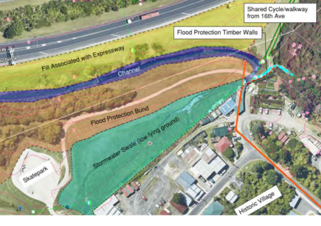
The Tauranga Northern Link (TNL)
13. In late 2019 the Government
announced the implementation of the SH2/TNL project. The Government
announcement identified that construction would commence in late 2020. The NZ
Transport Agency Waka Kotahi (NZTA), as the Governments delivery agent for the
TNL, are now progressing the procurement process to appoint contractors to
deliver the project. This is programmed to be completed in late 2020.
14. A key element of the TNL
project is the construction of an onramp from the 15th Avenue to
SH29. An NZTA image of this on-ramp is shown on Image 2, below. The new on-ramp
is over and across some of the same land and area required for a potential 17th
Avenue emergency vehicle access.
Image 2: NZTA image on new TNL 15th Avenue
onramp
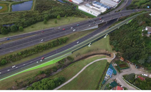
15. The timing for construction of
the new 15th Avenue on ramp within the wider TNL construction
programme is still to be confirmed. Discussions with NZTA have identified that
it’s very unlikely that an on ramp and an emergency access from 17th
Avenue can both be provided. Further, that once construction for the 15th
Avenue on ramp commences it is very likely that any emergency vehicle access
would need to be removed.
Cameron Road
short-term Multi-modal project
16. The Cameron Road short-term multimodal
project (Stage 1: CBD to 17th Avenue) is currently in development.
This project has the following goals:
(a) Improving the bus network.
(b) Improving safety for people
who travel by bike.
(c) Making Cameron Road safer and
more attractive for people to walk along and to cross Cameron Road.
(d) Making Cameron Road an
attractive area where people want to spend time (e.g. improve the street
corridor through plants, green areas, and improved street furniture).
17. Currently this project is
developing options to meet the above goals. The options include interventions
like bus clearways, bus lanes and other bus priority measures (e.g. signal
pre-emption at intersections) on Cameron Road between 15th Avenue
and 17th Avenue. These elements of the Cameron Road project could,
if agreed through the projects development, improve emergency vehicle access
along Cameron Road.
SCATS
Traffic control system
18. Tauranga’s traffic signals
use the ‘SCATS’ technology. SCATS is a traffic control system
designed to optimise traffic flow. Innovations are emerging to equip
buses and/or emergency vehicles with GPS trackers and connectivity modules that
can influence signalling systems and in doing so adjust the traffic flows.
19. The Tauranga Transport
Operating Centre (TTOC) are currently considering purchasing a Public Transport
module for SCATS. An extension of this system for emergency vehicles is also
possible. Further investigation is however required to confirm the feasibility,
timing and cost of this technology for Tauranga. If feasible then its
implementation could improve emergency vehicle access along Cameron Road.
Strategic / Statutory Context
20. Improving emergency vehicle
access supports the Community Outcomes most related to:
(a) Is inclusive, safe, resilient
and healthy
(b) Has predictable travel times
and travel choices
Options Analysis
21. Five potential routes between
17th Avenue and SH29 and SH2 were identified. These are shown on
Image 3, below:
Image 3: Potential Emergency Vehicle Access Routes
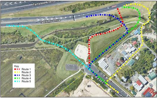
22. Of the five potential route
options, one route (Option 1, shown below in Image 4) has been investigated in
detail. An initial high-level assessment of the issues of the 5 route options
identified either issues common to Option 1 or significant constraints with the
other 4 options (e.g. topographical / steep gradient; impact on flooding
storage area; wetland) meaning Option 1 was identified as most feasible and
appropriate to investigate in more detail.
Option 1
23. This option follows the
existing bund, approximately via the existing cyclepath/footpath towards the
existing stream where a new culvert or bridge structure would be required to
enable access to the state highway.
24. The access route would be
one-way only. It would cater for ambulances (i.e. vehicles smaller than 2.4m
wide and 7m in length), and when used by an emergency vehicle not cater for
combined use with pedestrians and cyclists. The access would have an operating
speed of 20km per hour. The access would be unsealed.
25. The access would be protected
and controlled by an automatic security gate system and security fencing to
ensure no unauthorised vehicles can access the route.
Image 4: Option 1 – potential route for emergency
vehicle access
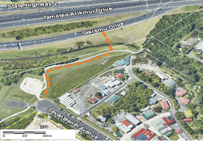
26. The
investigation into the feasibility and issues with Option 1 identified:
Planning/consenting:
27. Regional Council consent
requirements for land disturbance, stormwater discharge to land and water,
potential discharge of contaminants (from road/traffic), disturbance of a
stream bed, surface water diversion and installation of a culvert.
28. City Council consent
requirements for earthworks, vesting of the access and contaminated land. It is
noted that other consenting requirements may be required once further technical
details and detailed design is confirmed.
29. NZTA requirement for
‘limited access’ approval.
Reserve:
30. The Reserve Management Plan
supports access for emergency vehicles. However, there is a need to consider
the effects on reserve users and stakeholder engagement/consultation if
appropriate before agreeing any works. Ngai Tamarawaho would need to be engaged
with further in this process and more generally on the proposal for emergency
vehicle access.
Flooding:
31. Widening of the stopbank may
impact on the stormwater storage area on the south eastern side of the stopbank
thereby requiring further works in this area.
Geotechnical:
32. While considerable
geotechnical investigations have been undertaken of the area in the past there
is a need for further analysis to support detailed design and specification of
works associated with the access.
Safety:
33. Option 1 is in close vicinity
of a high pedestrian and cyclist environment (e.g. access to Koprererua Valley)
and recreational facilities (skate park; cycle training area), and crosses over
existing pedestrian and cycling paths. People (including children) using these
paths and facilities may be distracted and not notice or expect an emergency
vehicle on the access.
34. Risks associated with the
introduction of an access onto the 80km/h state highway:
(a) Emergency vehicles would enter
state highway at a location where drivers are making changes/decisions to
either access SH29 (Toll road) or SH2 to Bethlehem. Introducing an access point
in this high speed (80km/h) area has the potential of serious injury or crash.
(b) Although there is 260m of
sight distance from the Option 1 entry point along state highway, which exceeds
the safe stopping distance at 80km/h speed limit, there is a real risk that
drivers may be exceeding the speed limit within this area.
(c) A warning system/signals to
slow or stop state highway traffic to allow an emergency vehicle to enter the
flow, may cause operational and safety issues with end and side swipe type
crashes. The approach to the Option 1 access point on state highway has no
convenient position for signage due to retaining walls, the steep bank and no
clear berm space for installation.
(d) Security fencing and automated
gate system would be necessary to prevent unauthorised use of the access on
both directions. Construction of a security fence introduces a roadside hazard
adjacent to the state highway. There is also a risk of system failure (of
automated gate, if installed), preventing emergency vehicles to access the
state highway, without the possibility to turn around in case of system
failure.
35. The NZTA have advised that the
schemes proposed would need to be designed in greater detail and subject to
pre-construction safety audits to determine if the proposed connections to the
on ramp can be achieved safely.
36. On
the basis of the issues identified through the Investigation the Table below
provides a summary of the advantages and disadvantages of progressing with
further design of an emergency vehicle access from 17th Avenue to
SH29 and SH2.
|
Option 1:
Proceed with further design on emergency vehicle access on 17th
Avenue
|
|
Advantages
|
Disadvantages
|
|
Potential to
deliver faster response time for emergency vehicles via 17th
Avenue (for a relatively short period of time, maybe 2-3 years until the TNL
15th Avenue on-ramp construction commences).
|
Potential abortive investigation and design costs, which
are currently unbudgeted, should the identified safety issues (access to SH;
access through the Reserve), geotechnical and stormwater issues prove unable
to be sufficiently addressed.
Potential for
the investment (preliminary estimated at c.$750,000) benefits not to be
realised given the likely need to remove any access once construction of the
TNL 15th on ramp commences.
|
|
Recommended?
|
No
|
|
Option 2: Not
proceeding with further design of an emergency vehicle access on 17th
Avenue
|
|
Advantages
|
Disadvantages
|
|
Alternative
solutions to provide improved emergency vehicle access to the state highway
could be investigated through signalisation improvements and other project
development (e.g. Cameron Road short term multi model project) and
improvements will be made through the construction of a southbound 15th
Ave connection to Takitimu Drive as part of the TNL project
|
The advantages
of improved emergency access is unlikely to be realised until the TNL 15th
on ramp is operational. Improved signalisation may improve access along
Cameron Road but the 15th Avenue on ramp is important to providing
better access to state highway. This may be up to 5 years away.
|
|
Recommended?
|
Yes
|
Financial Considerations
37. The
preliminary cost estimate of the Option 1 concept identifies that an emergency
vehicle access could cost in the order of $750,000. There is currently
no project in the Long Term or Annual Plan which provides for these estimated
costs.
Legal Implications / Risks
38. There are no
legal implications/risks associated with the findings of the Investigation.
Should UFTD resolve to progress further design of Option 1 then there are a
number of risks (e.g. safety; engagement; cost) that would need to be further
investigated and addressed prior to a decision to progress to construction. A
summary of the risks is provided below and provided in more detailed in
Appendix 1.
Table 1: Risk outcomes
|
Risk Assessment Table
|
|
Ability to deliver
|
High
|
|
Planning
|
Medium
|
|
Geotechnical
|
High
|
|
Stormwater
|
Low-Medium
|
|
Traffic and Safety
|
High
|
|
Existing Utilities
|
Low
|
Consultation / Engagement
39. A meeting with a
representative of the Order of St John identified that improved response times
would be desirable. It would contribute to reduced vehicle use times and
thereby increase their availability but more importantly improve their response
times to emergency events. The Order of St John have simulated/modelled that
based on the 2018/2019 financial year call outs a direct access to SH29 would
improve the average response time throughout the region by 0.2 minutes per
journey.
40. NZTA have advised that they
are supportive in principle of the concept but note that the concept needs to
be designed in greater detail and subject to pre-construction road safety
audits to determine if an emergency vehicle access can be achieved safely. The
NZTA note that connections of this type are unusual and present significant
risks and challenges to the designer, due to the differential volumes and
speeds of vehicles of merging traffic at the intersection (access / state
highway).
41. NZTA also note that given the
short-term nature of the emergency vehicle access due to the construction of
the TNL 15th Avenue on-ramp, it is questionable if the benefits
sought are sufficient to off-set the risks and potentially significant costs
that may be incurred during the necessary development of the options to
determine feasibility. There is as risk that these professional service costs
may be abortive if a safe solution cannot be developed.
42. Ngai Tamarawaho have advised
that while the principle of improving response times for ambulances is
supported, they would be concerned if this impacted on the aspiration to
develop a more formal entrance to the Kopurererua Valley from 17th Avenue. They
also noted a concern related to potential impacts (e.g. sedimentation) on the
Kopurererua stream and wetland as a result from construction and subsequent use
of an access. Ngai Tamarawaho also identified with the issues of how safe
access from 17th Avenue to state highway could be provided and how any access
could be provided given the TNL 15th Avenue on-ramp is to be constructed.
Significance
43. From a financial perspective,
both construction costs and annual operating costs are considered to be
classified as ‘low’ significance. However, the construction of an
emergency vehicle access may be of wider public interest depending on potential
safety issues it presents for those people using the skate park, accessing the
Kopurererua Valley, or using State Highways 29 and 2.
Next Steps
44. If UFTD decides to proceed
with Option 1 the following next steps can be undertaken:
(a) Development of a preliminary
design to enable identified issues/risk and costs to be better understood
including through a road safety audit.
(b) Engagement with the NZTA on a
preliminary design.
(c) Engagement with Nagi
Tamawaraho
(d) Engagement/Consultation with
key stakeholders, including the Order of St John, local community including
Reserve users, and Bay of Plenty Regional Council (stormwater consent).
45. If UFTD decide to proceed with
Option 2 the following next steps can be undertaken:
(a) Through the Cameron Road
short-term multi-modal project ensure consideration is given to how responses
may support improved access for emergency vehicles (through use of bus
clearways; intersection priority) along Cameron Road.
(b) Through TTOC’s SCATS
investigation consider the benefits of purchasing a module with an extension
element for emergency vehicles.
Attachments
1. 17th
Ave to SH2/29 Emergency Access Feasibility Assessment (Aurecon) - A11630550 ⇩ 
|
Urban Form and
Transport Development Committee Meeting Agenda
|
21 July 2020
|


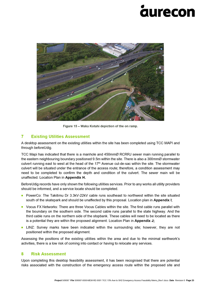


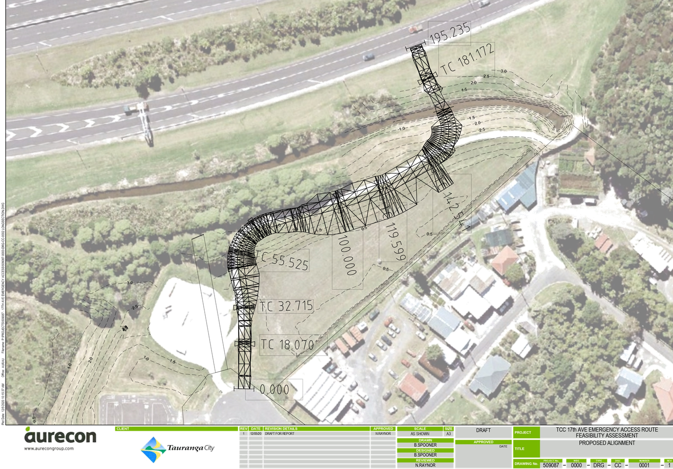

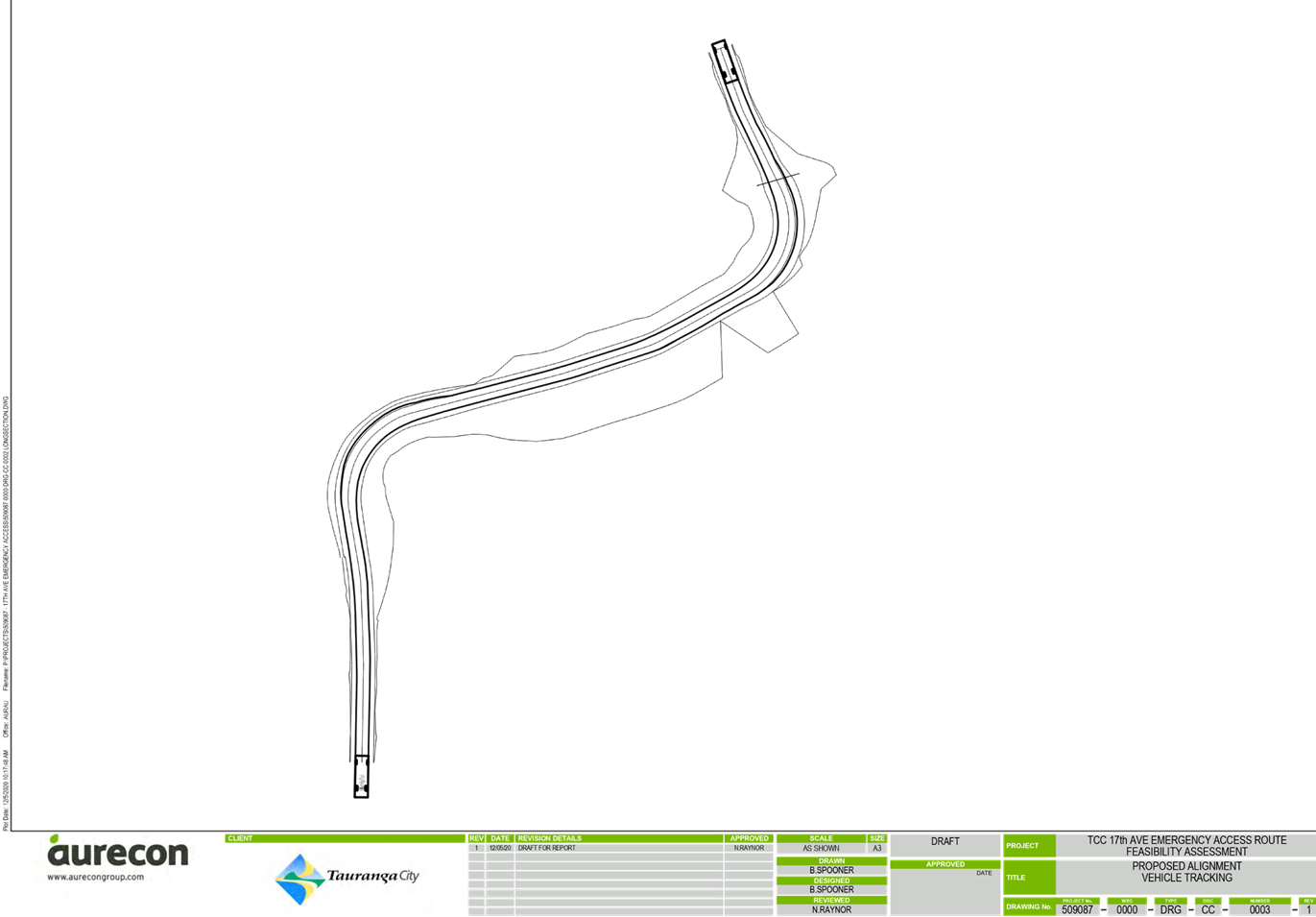
9.5 Arataki
Bus Facility
File
Number: A11599530
Author: Clare
Cassidy, Principal Transport Planner
Peter Siemensma, Senior Transport
Planner
Alistair Talbot, Team Leader:
Transport Strategy & Planning
Authoriser: Christine
Jones, General Manager: Strategy & Growth
PURPOSE OF THE REPORT
To provide the
Urban Form and Transport Committee (UFTD) with a summary of the findings of the
Arataki Permanent Bus Facility work and to obtain direction from the committee
on the assessment and recommendations to confirm the next steps.
|
Recommendations
That the Urban Form and Transport Development Committee:
(a) Receives
the report “Arataki Bus Facility”
(b) Agrees to progress concept
design, costing and planning for both shortlisted sites (Bayfair and St. John
Ambulance site off Girven Road) using funding included in the draft 2020/21
Annual Plan.
(c) Agrees to engage on both
site options with a stakeholder reference group and the wider public.
|
Executive Summary
2. High quality public
transport infrastructure supports the Bay of Plenty Regional Council’s
Public Transport Blueprint (‘Blueprint’), which is endorsed by
Council.
3. The temporary bus
facility on Farm Street is the second busiest public transport destination in
Tauranga but is not satisfactory for bus users or local residents and creates
issues from a network perspective. Local safety and multi-modal improvements
cannot be progressed until a permanent location for the facility has been
determined.
4. Sites throughout
Arataki have been assessed with the area around Farm Street generally
performing best as it provides good access to key destinations as well as the
residential catchment north of State Highway 2. Two sites have been
shortlisted: part of Arataki Park currently used by St. John Ambulance on
Girven Road; and a location within the Bayfair Site accessed from Farm Street.
5. Since the last
paper to Council (DC272 in September 2019) considering the St. John site on
Girven Road, staff have been working with Bayfair and their owners, to find a
suitable site on their land, and bring it up to the same level of
understanding. Both sites have significant, but very different advantages,
disadvantages and risks to be considered. This report is intended to update
Council on progress and determine next steps for public engagement and the
project as a whole.
Background
Arataki as a PT origin and
destination
6. The current
facility has the second highest boarding numbers for the city. This reflects
the key destinations nearby as well as being a location serving a significant
residential catchment. Whilst the number of transfers at Bayfair has increased
since the Blueprint Network went live, boardings originating at the facility
(not transfers) have consistently exceeded 20,000 people per month. Total
boardings (including transfers) have exceeded 30,000 for five of the last recorded
six months.
7. Arataki is a significant
PT destination regardless of whether a hub and spoke model where the facility
also accommodates transfers is retained or not. Safe,
convenient and comfortable public transport facilities in the Arataki area are
of strategic importance to the success of the public transport network and
therefore the transport network as a whole.
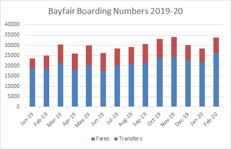
The existing (temporary) bus
facility
8. The bus facility on
Farm Street adjacent to the Bayfair Mall has been operational since mid-2018.
The facility is intended to be a temporary one, until a long-term solution is
found.
9. The temporary
facility does not provide an adequate level of service for the large number of
people that access public transport there. There is inadequate seating and
shelter, and poor legibility with very limited scope to improve the facility at
its current location. A survey of people using the facility in 2019 identified
that seating and shelter were their key problems with the current on-street
facility.
10. Some Farm Street residents are
concerned about the volume and speed of buses and traffic as well as social
issues occurring at the bus facility. There are wider concerns for the safety
of other road users, particularly those on bikes and walking to local schools.
Whilst some issues have been addressed, further improvements within Arataki
cannot be progressed without determining the long-term location and format of
the bus facility.
Network impacts of the current
facility and routing considerations
11. The existing facility does not
perform from a network perspective, as there is no ability for buses to turn
around safely, necessitating a loop around local streets. In turn, this looping
increases the impact of the facility on residents. 31 buses per hour depart
from the existing bus facility, although without the need for looping, this
would represent 21 movements per hour (since many “terminating”
services layover for a few minutes and become a departing service). Bay of
Plenty Regional Council have identified that a facility allowing buses to turn
around would allow them to remove all buses from Leander Street and almost
halve the number of current movements along Farm Street. The cost of this
additional running for the BoPRC is approximately $34,000/annum.
12. Regardless of the location of
the permanent bus facility, it is likely that Grenada Street, Farm Street and
Links Ave will continue to form the key route for public transport through the
Arataki area. Whilst State Highway 2 can carry express services between
Papamoa, Mount Maunganui and the CBD, the local street network provides PT
access for Arataki residents from Sandhurst Drive to Golf Road within a
convenient and safe walk distance that does not require crossing of the state
highway.
13. Alongside the PT Facility
project, a wider project to manage transport movements through the Arataki
area, provide for the safe movement of all road users and improve amenity needs
to be progressed. Confirming the long-term location for the Arataki bus
facility is essential to successfully progressing this.
Shortlisting of potential sites
for the bus facility
14. Sites throughout the Arataki
area as well as north of State Highway 2 have been assessed for a permanent
facility, with the area around Farm Street generally performing best as it
serves the key destinations in the area as well as the residential catchment. The
preference for a location close to Bayfair and Farm Street was re-confirmed by
BoPRC in May 2019.
15. Sites to the north of State
Highway 2 were not considered appropriate (even if an underpass were included
in the BayLink project), as they would either require buses to bypass the
Arataki area and use SH2, meaning that the Arataki community would lose access
to public transport, or buses would have to divert to the north SH2 and back
again adding time, cost and unreliability into the network as well as
undermining legibility and customer experience.
16. Despite this, the driving
range site adjacent to the Matapihi Road intersection was looked at in more
detail and discounted due to a lack of adequate space (particularly for future
proofing); access undermining the efficiency of the BayLink signals; and impact
on the operation of the golf course.
17. Two sites have been
shortlisted following numerous reports to Council: part of Arataki Park
currently used by St. John ambulance on Girven Road; and a location within the
Bayfair Site accessed from Farm Street.
Progress on the Bayfair site
18. Since the last report to
Council on 10 September 2019, staff have been working with Bayfair and their
owners, to understand costs and whether there is a mutually agreeable location
that works from a size and operations perspective. This work has been completed
and now brings the Bayfair site up to the same level of understanding as the
St. John site from a design feasibility and land cost perspective.
19. A constraints mapping exercise
undertaken with Bayfair and their consultants identified that there was only
one feasible site within their land holding that had adequate space available
and met the bus access requirements. This site is accessed off Farm Street and
is in the parking area behind the Farmers store. A concept layout was produced
to determine the land area required and negotiate costs with Bayfair.
20. Whilst Bayfair are working
with Council to find a mutually acceptable solution, they are unwilling to
enter into negotiations to sell the land required. This is a common approach
from such developments and has been the case on projects involving other
shopping centres in the city. Discussions have been based on entering into a
long-term lease arrangement should the site on Bayfair be chosen as the
preferred location. These are discussed in more detail in Confidential Attachment
1.
Progress on the St. John site
21. The focus of the report to
Council in September 2019 was on the St. John site, and issues around: planning
and the Reserves Act; site size; access and feasibility. Subsequent work has
focused on access from Girven Road.
Assessment of the two sites
22. The assessment of customer and
network factors for the St. John site against the Bayfair off street option has
been updated by Abley Transportation Consultants to reflect the increased
understanding of the format and location of the Bayfair option. This table is
attached in Attachment 3. Indicative drawings of the St. John site are
attached in Attachment 4, and indicative drawings of the Bayfair site
are attached in Attachment 5. The table gives an analysis of each
site from the perspective of the PT network issues and customer needs but does
not assign a level of importance to each factor. For example, safety issues
created at one site, would have a higher level of importance than other issues
that may be mitigated in some way. Staff commentary on the assessment is
included in the following paragraphs along with consideration of other factors
based on planning, funding and community issues.
Key assumptions
used in the assessment
23. If the St. John site were
selected, bus stops would still be required on Farm Street close to the
existing location to provide access to the community living between Girven Road
and Concord Ave who would otherwise have a significant walk distance to access
public transport. This would require a full stop to be provided on both sides
of Farm Street to avoid the existing loop model using Leander Street and to
reduce the number of bus movements along Farm Street.
24. For the St. John site, it is assumed
that buses originating to the east of the bus facility (Papamoa, Wairakei, Te
Puke etc.) will terminate at the facility and not travel down Farm Street. This
would not significantly reduce the number of services travelling down Farm
Street because the majority of terminating services become a new service after
laying over for a few minutes. However, this would create additional walk
distance and conflict points for passengers accessing the Bayfair Mall which is
the key destination for people travelling to the facility.
Network
factors
25. Overall, from a bus and
transport network perspective, the Bayfair site continues to perform better
than the St. John option. The key issues relate to the likely bus and
pedestrian demands on the planned traffic signals at Marlin Street and the
manoeuvring and conflict point issues relating to either possible layout for
the St. John site.
26. The St. John site does allow a
greater scope for future expansion of the facility if required, whilst any
expansion of the Bayfair site would likely need to be accommodated on-street.
27. All services originating from
Mount Maunganui and Tauranga would have a longer distance to travel to the St.
John facility compared to a Bayfair facility with a risk to reliability through
the Marlin Street signals. This would only be partially offset by the reduced
distance for services from the east, which are fewer.
28. The planned traffic signals at
Marlin Street would need to include a fourth arm to accommodate the bus
facility on Girven Road. This would allow buses to safely enter and exit the
facility and also provide for pedestrian access between the bus facility and
Bayfair. The right turn bay required for buses to access the facility would
require some localised widening on Girven Road, between the Marlin Street and
Grenada Street intersections.
29. Transport modelling undertaken
in Aimsun indicates that the intersection should function with an adequate
level of service. The fourth arm and high pedestrian demands would result in
additional delays on Girven Road and in one scenario this would result in trips
diverting to other parts of the transport network. However, the model shows
that those diversions can be accommodated on the local network. A memo
summarising the modelling results is included in Attachment 6.
30. There are two potential layout
options for the St. John site, both of which create issues with regard to
potential pedestrian and bus conflicts. The option for St. John which does not
encroach further into the reserve requires two-way flow for buses with high
potential for manoeuvring conflicts and / or buses queuing back into the
intersection. The option that does encroach further into the reserve would
result in additional loss of parking and longer detour distances for passengers
transferring between services. Both options create significant risk for bus vs
pedestrian conflicts.
31. The layout issues for the St.
John site also affect the legibility of the facility for passengers. Whilst the
legibility issues could be partially designed out and addressed through
wayfinding, the conflict points and likely safety issues cannot be designed out
and are considered to have a high potential significance.
32. More bus bays can be
accommodated at the St. John site, with a greater ability to future proof for
expansion. BoPRC have indicated that the current requirement is for six bays,
with a preference to be able to expand to 8-10 bays in the medium term. At the
Bayfair Site this expansion would only be feasible by using bays on the Farm
Street side of the facility.
33. All options allow for
independence of bus movements and would result in the loss of parking spaces.
34. The St. John site would
require greater provision of facilities for both drivers and passengers, but it
would be feasible to include these in the project.
Customer
Factors
35. The Bayfair site strongly
outperforms the St. John site from a passenger perspective.
(a) Safety issues exist for the
St. John site in terms of vehicle and pedestrian conflict that cannot be
designed out. Safety issues for the wider local road network would exist
regardless of the bus facility location and mitigation measures for them will
be a key part of the next stage of the project.
(b) Personal safety and social
issues for the Girven Road site would be problematic due to the lack of passive
surveillance from pedestrians and traffic. The main waiting area would be
towards the eastern side of the site and away from Girven Road. Lighting and
CCTV would help to mitigate this, but it would not perform as well as the
Bayfair site which is busier and overlooked by residents as well as the
day/night activity of the Mall.
(c) Both likely layouts for the
Girven Road option would create issues for transferring passengers, in terms of
the likely walk distance and number of crossing points within the facility to
access different stops.
(d) A survey of bus users
undertaken in 2019, identifies a strong preference for the facility to be
located at or very close to the existing facility. The survey also identified
that Bayfair (or a home within a short walk) are the key destinations for trips
ending at the facility (rather than other destinations around Girven Road). If
stops are retained on Farm Street, this would be more of an issue for
passengers originating in and to the east of the facility, however, the stops
on Farm Street would need to be high quality and provide adequate shelter for
the volumes of passengers likely to use them.
(e) The Bayfair option has much
larger residential catchment (within a short walk) than the Girven Road option,
which again would be less of an impact with high quality stops and shelters on
Farm Street.
Planning
issues and timeframes
36. The Bayfair site would require
resource consent, which could be a lengthy and contested process due to likely
opposition from affected residents. It is possible that any decision by Council
could be appealed to the Environment Court.
37. The St. John site would
require the reserve status of the site to be revoked, a likely lengthy public
process that requires Ministerial approval (Ministry of Conservation). It
is likely that any resource consent needed for the development of a permanent
bus facility on the St John site would require public notification and could
also be appealed to the Environment Court.
Community
issues
38. Both options reduce but
don’t remove buses from Farm Street. Bus stops will continue to be
required on Farm Street, either as stops and shelters on both sides of the road
if the main facility is elsewhere, or integrated into a facility at Bayfair.
39. Wider work needs to be
undertaken to resolve bus network issues for both Farm Street residents and the
wider Arataki community. Significant engagement activities will be required to
determine how best this can be achieved.
40. The St. John site has not yet
been tested with residents on Girven Road and Gloucester Road that would be
affected by that option. There is a potential for opposition from those
residents and from users of the bus network. The footprint of any facility on
Arataki Park would require the removal and relocation of the existing
playground and potentially some other facilities. The bus facility would also
affect the directness of the planned route through Arataki Park for pedestrians
and cyclists.
41. As part of the investigations
for the Council paper on 10 September 2019, initial discussions have been held
with St John Property and Facilities Manager (Central Region) in relation to
Council exploring options for an Arataki bus facility on a number of sites,
including investigations into using the site currently occupied by St John on
Girven Road. St John explained they are open to further discussions with
Council about future options for this facility, including the possibility of
re-location or co-location.
Key risks
42. If Bayfair was discounted and
the Reserves Act process for the St. John site is unsuccessful, Council could
be left with no viable option on the table. This is also likely to create a
negative response from BoPRC and from bus users as well as undermining the
attractiveness of Public Transport for potential users.
43. Council would need to work
with Bayfair on design of a facility on their land, which could have potential
to inflate costs related to design and structural / amenity elements of the
design.
44. Initial conversations have
been held with Auckland Transport to understand experience with bus facilities
located on private land. Whilst examples exist, it was noted that risks could
occur over future maintenance, growth, (minor) improvements or upgrades. Whilst
tenants of a shopping centre have the option to terminate a contract over time,
with significant investments on private land, Council would have limited
options to change things in future. As a result, Auckland Transport has a
preference to develop bus facilities on Council owned land if possible.
45. If Council engages with the
community on both sites, there is a reputational risk if for any reason (such
as issues with the planning process or cost) Council chooses the site that is
“less popular” with the community. This approach would also require
a lengthier process, where Council would engage on the two sites, and again on
wider network improvements once a site is selected.
46. If Council engages on Bayfair
being a preferred option with the engagement based around how that facility and
the surrounding transport network can best be designed to resolve community
issues, this is likely to create significant negative response from Farm Street
residents. However, if planning processes were unsuccessful the St. John site
would not be precluded.
47. In terms of the Bayfair
option, the current terms agreed in principle includes a Relocation
Clause. This enables AMP to relocate the bus interchange after the first
five years. If relocation occurs in years 5 – 20, this will be at
the cost of the Lessor (AMP), and the Lessor is to consult with Council.
If relocation occurs from year 20 onwards, this will be at Council’s
cost. AMP’s position is that they wish to retain flexibility
for any future expansion plans which may arise over time.
48. Valuation advice in relation
to the Bayfair option indicates that almost all ground leases are in some way
tied to land values, and therefore land value escalation carries significant
risk to any ground lessee (Council). This is discussed further in the Memo and
valuation advice in Confidential Attachments 1 and 2.
Strategic / Statutory Context
49. High quality public transport
infrastructure supports the Bay of Plenty Regional Council’s Public
Transport Blueprint, which is endorsed by all of the transport partners. The
goals of the Arataki Multi Modal project also support the Tauranga Cycle Plan.
Improved public transport infrastructure and services also relate to the
Tauranga Transport Programme and the wider work being undertaken through the
Urban Form and Transport Initiative.
OPTIONS ANALYSIS
50. Council
has been keeping the Arataki community informed via e-newsletter and drop-in
sessions with staff and Councillors. There has been a gap in communication
during Covid-19 and the approach to engagement with both Arataki residents,
plus key stakeholders, bus users and the wider community needs to be agreed to
move forward with the project.
51. A pilot engagement approach is
being developed for the Arataki area by the engagement team in partnership with
Transport and other teams within Council. This identifies that there are a
range of activities and potential projects within the area from various parts
of Council and other agencies. To date, engagement and consultation has been
carried out on project basis meaning that:
· Many
projects are working with different residents and interest groups which is
inefficient and tiring.
· The
narrative is often focused at the project/task level rather than a big picture
whole of programme discussion.
· The
project teams don’t always have visibility and understanding of what
other teams are doing.
· As a
programme our work can feel disjointed to groups/community.
52. The
proposed approach is to create an overarching stakeholder reference group that
would act as a programme steering group guiding the projects made up of
delivery agencies and representatives from the various interest groups within
the Arataki community bringing all views into one arena. This group would not make
decisions but would consider and report on all matters related to projects
before going to Council for decision and allow a forum for the community to
raise matters of interest or concern to the community and delivery agencies.
The final approach and structure will be very much dependent on what the
community tell us about how they want to engage with Council and other
agencies. It is anticipated that engagement with a reference group would occur
ahead of wider public engagement.
53. Council can opt to choose a
preferred site and engage on that basis through the stakeholder reference
group, or to engage on both options. An alternative to this approach would be
to use the analysis undertaken to date to feed into the Transport System Plan
and the Single Stage Business Cases that will be undertaken over the next 12
months so that the location of the bus facility and measures on the wider
transport network can be considered as part of the wider project. There are
advantages and risks to each approach that are described in the table below.
|
Option Description
|
Pros
|
Cons
|
|
Option 1
Produce concept designs
for both options ahead of engaging on both options to determine how best any
negative impacts can be mitigated.
Recommended
|
Allows both options to
be fully considered (which maximises chances of achieving NZTA funding)
Cost estimates can be
produced for both options
Less risk that no
viable option will be found
Allows impacts on
residents, commuters and bus users for both sites to be considered to enable
a mitigation plan to be developed for both sites
|
Increases analysis and
costs to develop concepts for both sites and undertake a longer engagement
process
Likely negative
response from Farm Street residents
The engagement could be
perceived as allowing the community to determine a preferred site which could
create reputational issues if that site cannot be progressed.
If Girven Road was the
site favoured by the community, there remains a risk around the reserve
revocation/reclassification process being successful.
|
|
Option 2
Discount Bayfair as an
option now, and work towards the St. John site as the preferred option.
Not recommended
|
Simplifies and reduces
cost of next steps.
Allows the engagement
to clearly focus on resolving issues on local streets with the community.
Provides early clarity
to Bayfair AMP.
|
Potential risk to NZTA
funding if a viable and technically preferred option is discounted early.
Council would be left
with no viable option if St. John site failed to progress through planning
process if Bayfair option has been relinquished.
Safety issues with the
favoured site that it is not possible to design out
Potential negative
response from neighbouring residents on Girven Road and Gloucester Street who
have not been consulted to date.
Likely negative
response from bus passengers and transport partners that a site that
disadvantages them significantly has been favoured without consultation.
|
|
Option 3
Discount St. John as an
option now and work towards the Bayfair site as the preferred option
Not recommended
|
Simplifies and reduces
cost of next steps.
Allows the engagement
to clearly focus on resolving issues on local streets with the community.
Provides early clarity
to Bayfair AMP and avoids the Bayfair option being lost.
The St. John site could
still be pursued if the Bayfair site did not progress.
|
Potential risk to NZTA
funding if a viable option is discounted early.
Likely negative
response from Farm Street residents.
Likelihood that Council
will have to cover the lease costs without funding from NZTA.
|
|
Option 4
Use all of the analysis
undertaken to date to inform the Transport System Plan, leaving the final
location and network treatments to be considered through the single stage
business cases
Not recommended
|
Consolidates Business
Cases and Engagement approaches affecting the area.
|
Delay in decision
making likely to result in Bayfair option being precluded, so if St. John
site did not get through the planning process there could be no viable option
left.
Delay likely to create
issues for the local community and increase the amount of time until
improvements on local streets can be progressed.
Delay would increase
the period of time that bus users have a sub-standard facility.
Potential requirement
for business case for bus facility to be progressed separate but aligned to
wider area focussed business case(s).
|
Financial Considerations
Costs
54. The land related costs
associated with the St. John Site and the Bayfair site are discussed in Confidential
Attachment 1.
55. The current concepts for both
sites have been developed to determine whether they have an adequate footprint
to accommodate the type of facility that is required. Further development of
the concept(s) will be required before high-level cost estimates can be
produced. Additionally, improvements to the local street network will need to
be designed and considered to ensure that all users can be accommodated safely
and efficiently.
56. There are a number of unknowns
around the planning processes for both sites (in terms of both costs and
timeframes) and around issues such as underground service relocations. These
should be refined through the next stages of the project.
57. An
assessment of similar facilities elsewhere in New Zealand indicates a likely
capital construction cost in the range of $5M - $15M for which there would be
an application for 51% co-investment from Waka Kotahi NZ Transport Agency. This
excludes land related costs (such as leases, or demolition / relocation of
buildings) but does include street improvements to accommodate the facility
(such as localised widening etc).
58. It
is anticipated that these costs would be prioritised through the 2021-31 Long
Term Plan Process. $400,000 is included in the draft 2020/21 Annual Plan to
progress with design, planning and engagement.
Funding issues
59. Both options require an NZTA
business case process to be followed to attract funding from the NLTF. A point
of entry is in development and the situation has been discussed with NZTA.
60. There will be a likely
crossover of some issues between the Arataki Bus Facility and Multi-modal Stage
2 project and one of the Single Stage Business that is progressed through the
Transport System Plan. This provides an opportunity for the projects to be
combined into a wider Business Case approach, however this would see the
resolution of the issue with the temporary facility delayed further. An
alternative approach is to ensure close alignment of the projects as they
development to support integration and coordinated delivery.
61. NZTA have informally
identified that they are unlikely to fund lease costs for Bayfair site or any
relocation costs for St. John.
62. There may be an opportunity to
seek a contribution from BoPRC for the bus facility. BOPRC have
previously indicated a willingness to enter into discussions on contribution to
public transport infrastructure. In a letter to TCC on 21 May 2019, BoPRC
outlined their preference for a new facility close to Bayfair on Farm Street.
This was re-confirmed in April 2020. Whilst BoPRC have stated that they could
accept a facility on the St. John site, selection of that site could make
funding from them less likely.
Consultation / Engagement
63. The proposed engagement
approach across the wider programme of activities in the Arataki area (as
described in the options section) will be refined ahead of further engagement
being undertaken.
Significance
64. Under the Significance and
Engagement Policy 2014 these projects will have a medium to high significance
as they progress, due to a potentially high level of public interest. Through
the development of the project, engagement plans will be prepared to reflect
this. It is expected that the capital investment for construction of a facility
will be considered through the 2021-31 Long Term Plan Process.
Next Steps
65. Next steps for the project
are:
(a) Further develop concept plans
and visualisations for the chosen option(s) for the purposes of public
engagement.
(b) Develop cost estimates for the
chosen options, based on the concept plans.
(c) Continue “point of
entry” conversation with Waka Kotahi NZ Transport Agency to determine
Business Case Approach and commence the business case
(d) Scope stage 2 of the Arataki
Multi-Modal project to reflect the option(s) chosen and likely impacts on the
local street network.
(e) Use the engagement process
developed for the wider area to test the option(s) with stakeholders and the
wider community.
Attachments
1. Confidential Memo
Arataki bus facility oprions TCC and AMP lease negotiations - A11632800 -
Public Excluded
2. Updated Telfer
Young advice on AMP lease proposal Farm St - A11614452 - Public Excluded
3. Arataki Bus
Facility - shortlisted sites analysis - A11630519 ⇩ 
4. Indicative
drawings for the St John's site - A11630516 ⇩ 
5. Indicative
drawings for the Bayfair site - A11630511 ⇩
6. Girven Road Bus
Facility Modelling Report (Beca) - A11624915 ⇩
|
Urban Form and
Transport Development Committee Meeting Agenda
|
21 July 2020
|


|
Urban Form and Transport Development
Committee Meeting Agenda
|
21 July 2020
|
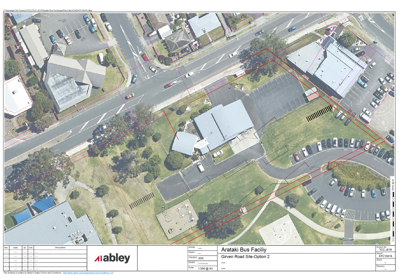
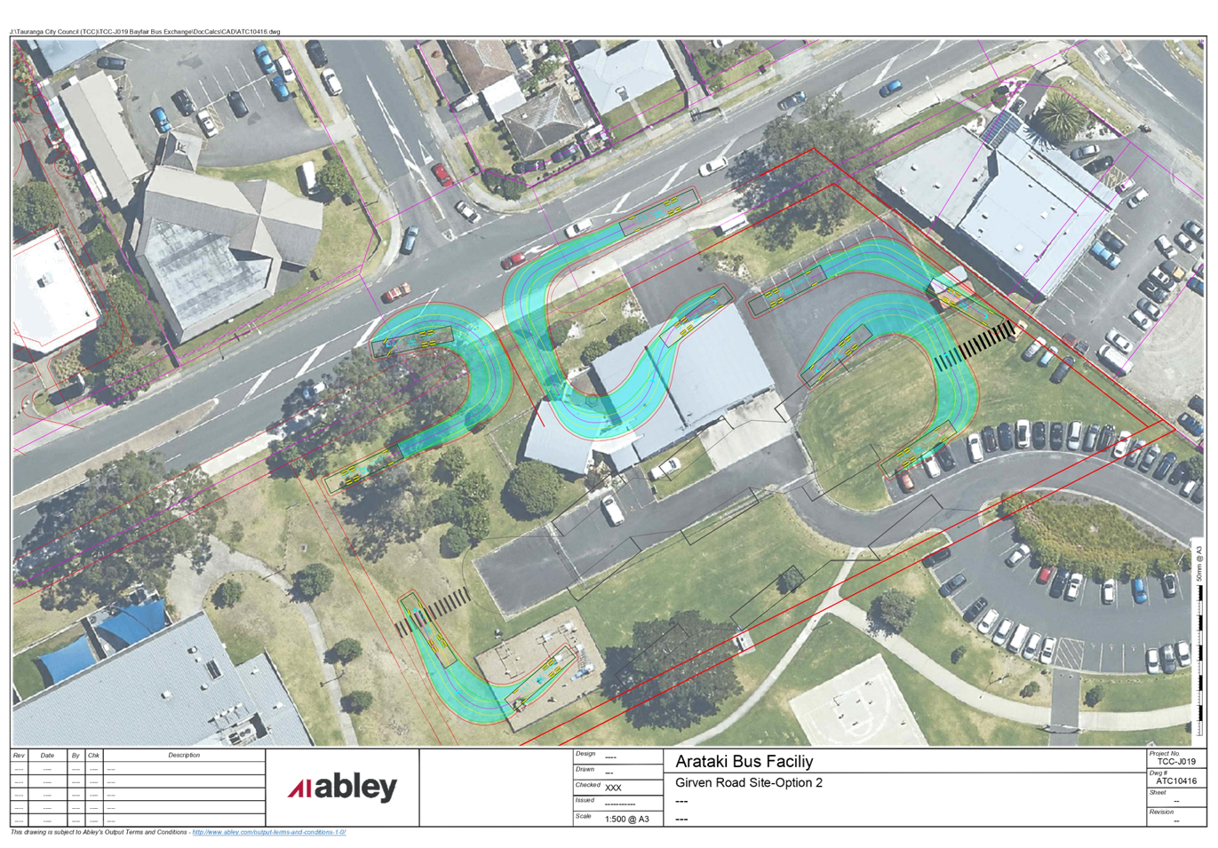
|
Urban Form and
Transport Development Committee Meeting Agenda
|
21 July 2020
|
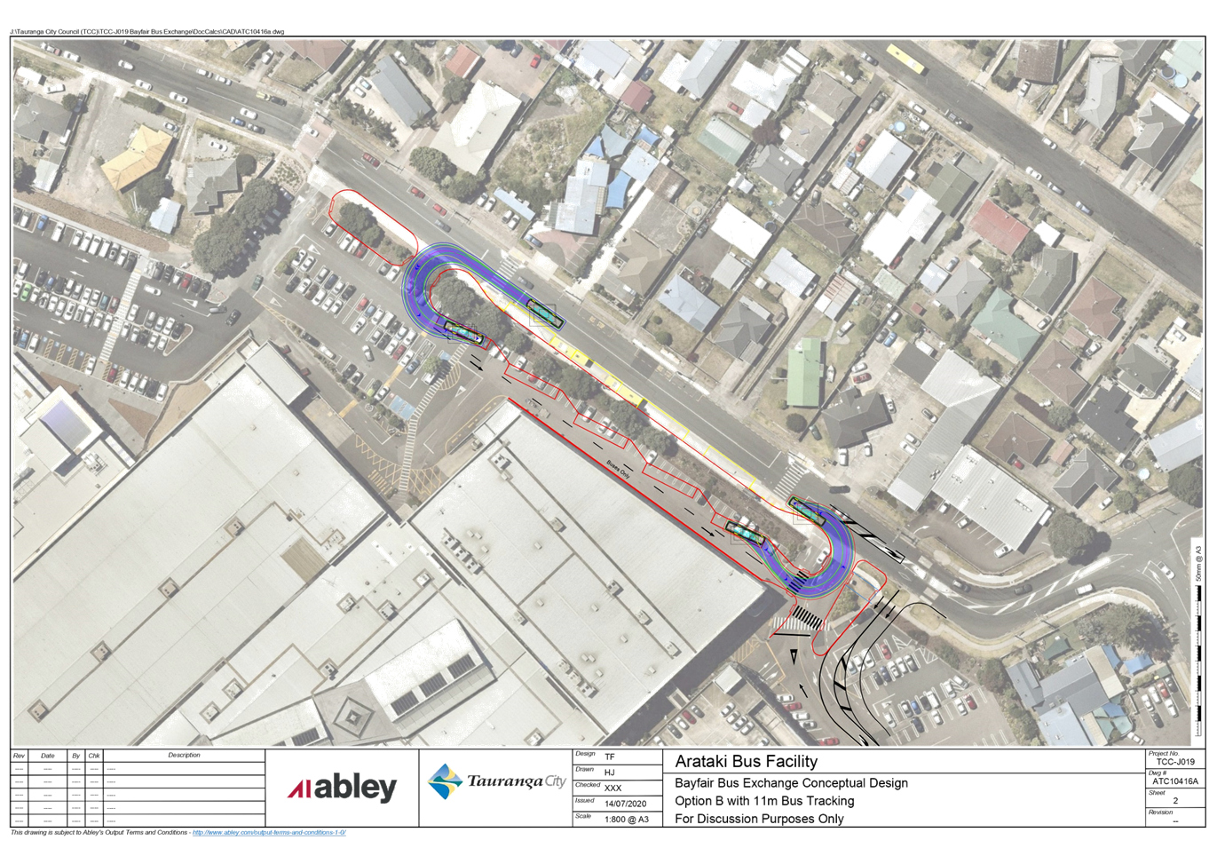
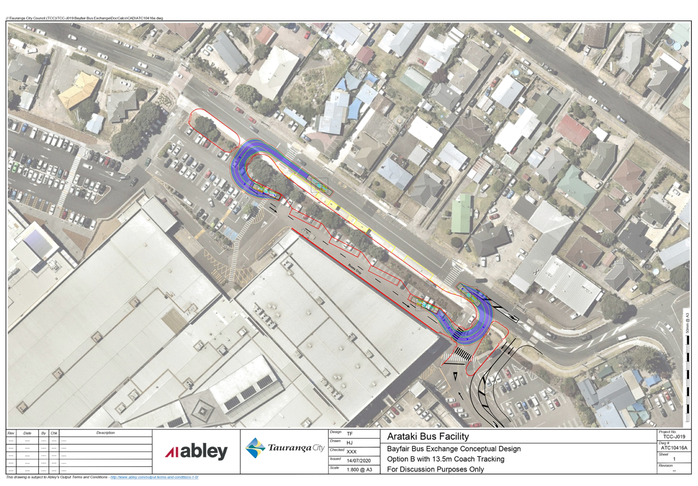
|
Urban Form and Transport Development
Committee Meeting Agenda
|
21 July 2020
|


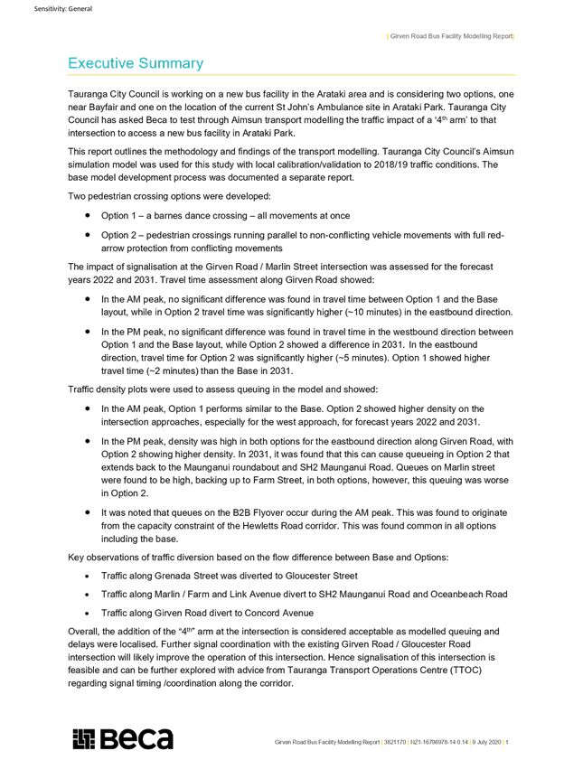


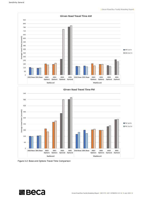

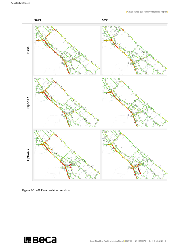
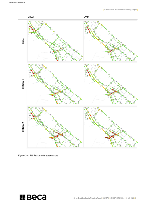
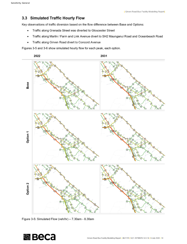
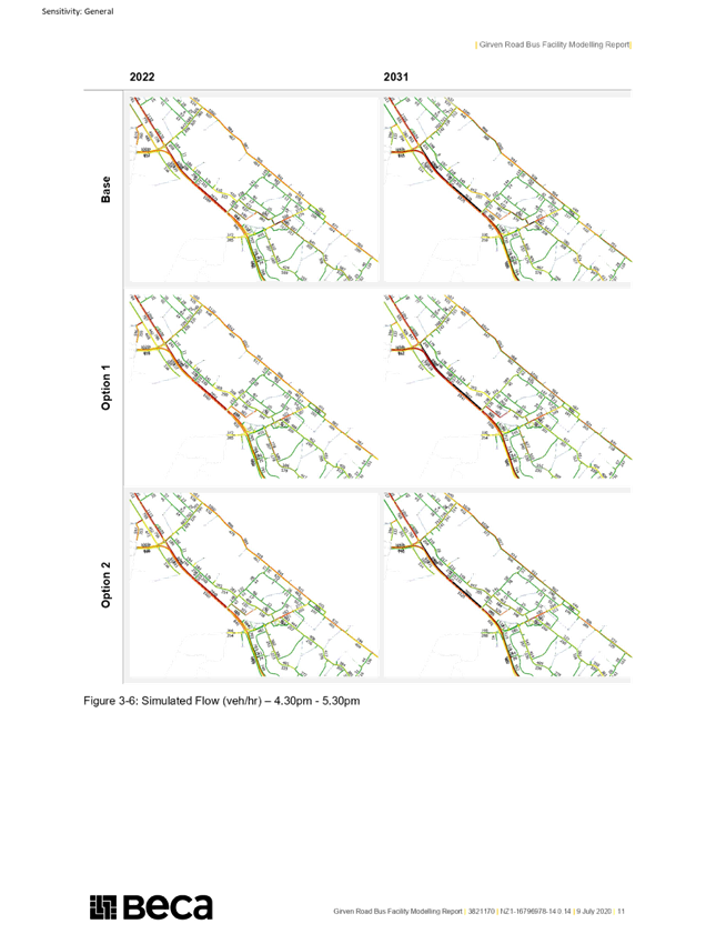

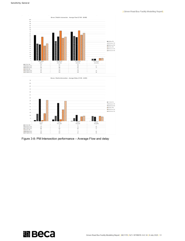


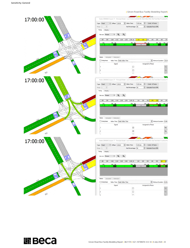


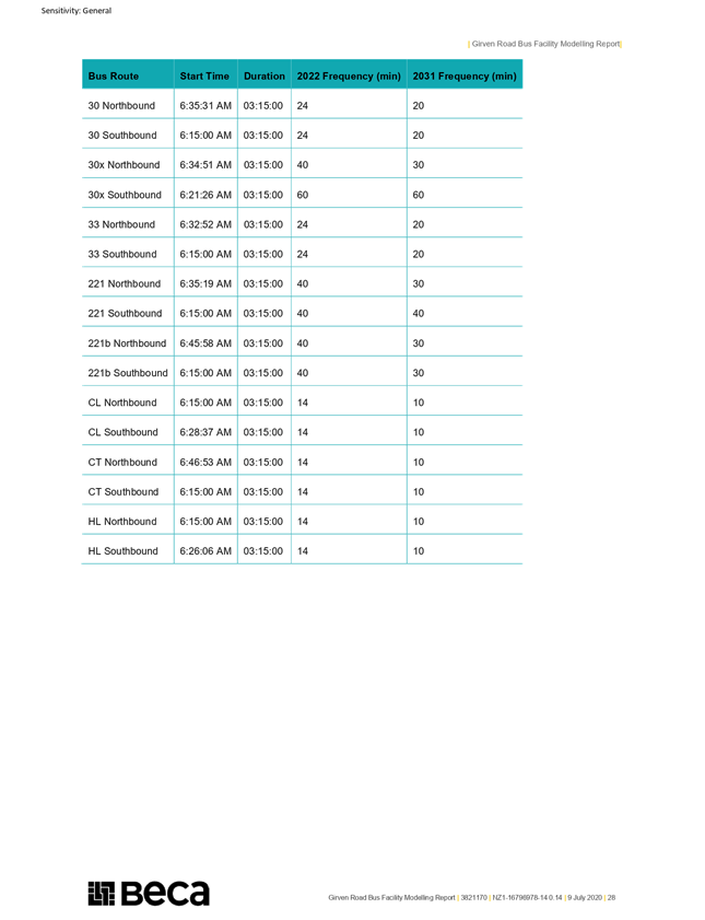

9.6 Covid-19
Recovery (Fast-track Consenting) Bill
File
Number: A11583224
Author: Andy
Mead, Manager: City & Infrastructure Planning
Campbell Larking, Team Leader:
Planning Projects
Authoriser: Christine
Jones, General Manager: Strategy & Growth
PURPOSE OF THE REPORT
To provide the
Committee with a copy of the submission lodged by the Chief Executive on the
Covid-19 Recovery (Fast-track) Consenting Bill.
|
Recommendations
That the Urban Form and Transport Development Committee receives
the submission (Attachment 1) on the Covid-19 Recovery (Fast-track)
Consenting Bill lodged with the Environment Committee on 20 June 2020.
|
BACKGROUND
2. The Covid-19
Recovery (Fast-track consenting) Bill is a new bill that aims to give the
Government temporary powers to fast track eligible development and
infrastructure projects under the Resource Management Act 1991 (RMA). The
purpose is ‘to urgently promote employment growth to support New
Zealand’s recovery from the economic and social impacts of COVID-19, and
to support the certainty of ongoing investment across New Zealand while
continuing to promote the sustainable management of natural and physical resources’.
3. To be eligible,
projects need to enhance economic recovery, through generating employment,
increasing housing supply, and providing the infrastructure required, while
addressing key environmental factors, including:
· Climate change,
· Minimising waste,
· Managing risk from
natural hazards,
· Promoting
protection of historic heritage, and
· Improving
environmental outcomes for coastal or freshwater quality, air quality, or
indigenous biodiversity.
4. Essentially,
projects need to demonstrate how they will boost growth and support the
transition to a low emissions, sustainable and resilient economy (addressing
risks from natural hazards and climate change).
5. This new Bill could
provide Tauranga with significant benefits for enabling urban development ahead
of re-zoning land for urban development, including provision
for housing and infrastructure, and community facilities including new schools;
particularly where applications gain from greater certainty and speed, thereby
helping increase employment opportunities in the community.
6. Some projects
(mainly transport and housing) have been specifically identified in the Bill
– none of these are in Tauranga. Applications for other projects
can be made for Ministerial direction after the Bill is enacted into law.
7. Submissions on the
Bill were invited to be lodged from the 17 June 2020 through to Sunday 21 June
2020. Given such a short timeframe, council staff prepared the submission
for sign off and lodgement by the General Manager Strategy and Growth
(with endorsement from the Chief Executive).
8. The position taken
in regard to the submission is that the Bill should be supported in principle,
as it could assist with quickly meeting the local growth demand pressures and
the housing shortfall, as well as accelerating rapid provision of transport
initiatives, strategic water and wastewater services if Council (or another
party) sought to use the Bill. There are, however, some key issues
which need to be addressed in the submission relating to:
(a) Extending the 2-year repeal
period;
(b) In relation to housing, urban
development and infrastructure projects we seek a lower test for non-complying
activities where applications align with urban growth strategies, spatial plans
or current urban limits;
(c) Ensuring that development
contributions can be required for consents granted under this legislation in
accordance with council development contribution policies as if the consents
had been granted under the RMA;
(d) The alignment of fast-tracking
consenting and designation processes within the Bill, to other Acts and
processes, such as land acquisition under the Public Works Act 1981 or Business
Case requirements (BC) by Waka Kotahi NZ Transport Agency. These
matters can lead to uncertainty, delays and funding issues for projects that
may wish to use the fast-track consent mechanism.
(e) How
infrastructure design, delivery and vesting is dealt with as part of any
development consenting process.
Strategic / Statutory Context
9. The Government is
currently working through a significant RMA Reform, development of a number
National Policy Statements and delivery of its urban growth agenda. This
includes the Urban Development Bill and National Policy Statements on Urban
Development, Freshwater and Biodiversity.
10. While not originally part of
the above agenda, the COVID-19 pandemic has shifted the NZ Government’s
focus to the need for a new system in the short term to promote employment
growth to support New Zealand’s recovery from the economic and social
impacts of COVID-19, and to support the certainty of ongoing investment across
New Zealand while continuing to promote the sustainable management of natural
and physical resources’.
Significance
11. This report does not raise any
issues of significance.
Next Steps
12. The Environment Committee will
receive submissions and consider these and make recommended change in its
report back to parliament. The Bill is expected to be passed into law
within the next 1-2 months.
13. In the submission lodged, TCC
has requested that it will make a verbal presentation to the Environment
Committee if this opportunity is available.
Attachments
1. Submission
to Covid-19 Recovery (Fast-track Consenting) Bill - A11631273 ⇩ 
|
Urban Form and
Transport Development Committee Meeting Agenda
|
21 July 2020
|


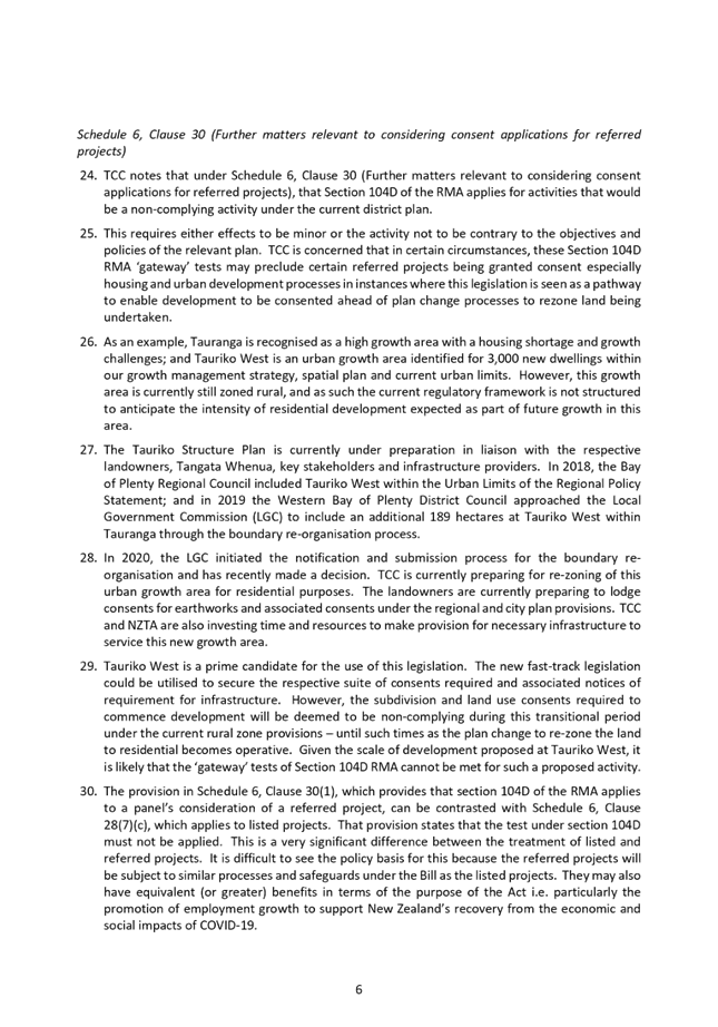
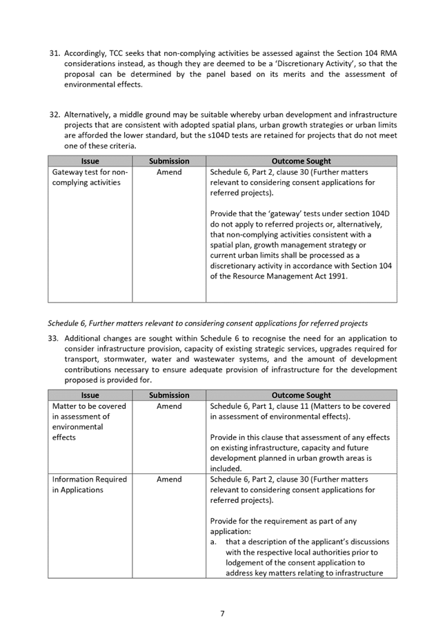
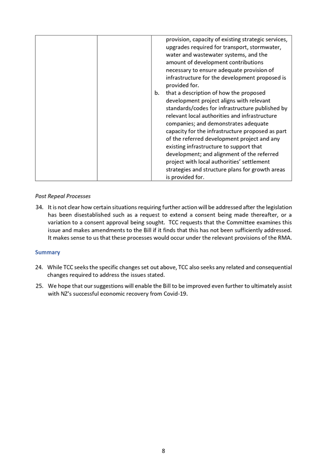
9.7 Infrastructure
Resilience Projects Proposed Scope Cost and Programme for LTP
File
Number: A11394406
Author: Steve
Raynor, Resilience Specialist: Infrastructure & Urban Form
Authoriser: Christine
Jones, General Manager: Strategy & Growth
PURPOSE OF THE REPORT
To provide an
update on the emerging outcomes of the three-year Infrastructure Resilience
Project in terms of risks identified, and projects identified for future
prioritisation to build a resilient citywide infrastructure.
|
Recommendations
That the Urban Form and Transport Development Committee:
(a) Receives the Infrastructure
Resilience Projects Proposed Scope Cost and Programme for LTP report.
(b) Notes the progress made on
the Infrastructure Resilience Project.
|
Executive Summary
2. The Infrastructure
Resilience Project, started in 2017, has reached the point where potential
hazard prone assets throughout the City have been identified and potential
mitigation projects scoped and costed. Some 300 projects have been identified,
rated for risk reduction and resilience contribution
3. At this time, it is
appropriate to inform the Urban Form and Transport Development Committee of the
overall project progress, approach taken and emerging outcomes of this work,
prior to the progression of projects into a prioritisation process and,
following that process, consideration of inclusion in the 2021-31 LTP and 30
year Infrastructure Strategy.
4. Progressing these
identified projects can overtime aid to the establishment of a genuinely
resilient city infrastructure Background
Background
5. The Infrastructure
Resilience Project began in 2017 with the United Nations five priorities for
reducing disaster losses as the underpinning approach developed for project
progression within the set project plan. At that point there was clear
awareness that:
· TCC
did not know, nor understand all natural hazard susceptibilities, including the
potential effects of sea level rise and
· TCC
had not determined the consequences (and therefore overall risk) to infrastructure
assets, and potential mitigations to reduce that risk.
6. The Infrastructure
Resilience Project formed with the goal of directly addressing these unknowns
and through research and design establishing an approach to deliver resilient
infrastructure for TCC horizontal assets of three-waters and roads.
7. A key milestone in
the project is concluding the identification of potential “at risk”
assets and determining appropriate risk reduction measures (i.e. mitigation) to
improve resilience and identify costs for prioritisation prior to consideration
of inclusion into the 2021-31 LTP.
8. These risk
mitigation projects have now been identified through mapping natural hazards
and TCC infrastructure assets in a GIS database, assessing risk, identifying
risk mitigation measures, costings those measures and determining
prioritisation for implementation. When implemented these works will:
· Add
security to already planned infrastructure investment;
· Build
robustness and rapid recovery principles into our infrastructure assets; and
· Integrate
future proofing into asset design and construction, including the renewal of
existing assets.
Updating and Concluding Natural Hazard Susceptibility
Modelling
9. TCC holds the
following natural hazard information, either developed ahead of this project or
developed as part of this project. This information considers a range of
natural hazard event likelihood/recurrence and associated potential sea level
rise impacts. All information is in the public realm, and currently
utilised across a range of planning, LGA 2004, CDEM 2002 and RMA 1991 and BA
2004 processes.
· Tsunami
· Earthquake
o Tauranga Shaking
Model
o Liquefaction and
Lateral Spread
· Sea
Level Rise
· Inundation
from storms (inner harbour)
· Erosion
o Open Coast
o Inner Harbour
· Flooding
from intense rainfall
10. TCC also holds information on
slope instability and is presently updating this information, which is due to
be completed in November 2020. This updated hazard mapping will be
released to the affected landowners and be available for use in all regulatory
and resilience processes at that time.
11. All hazards used in the
Infrastructure Resilience Project are spatially mapped within GIS to show each
hazard in terms of different return periods and time horizons. An example is
inundation is mapped with 50-year, 100-year and 500-year return period storm
events and each of these are mapped with sea-level rise projections for 2080
and 2130 which are the current, 50-year and 100-year scenarios. This provides
an extensive database for analysis and use in determining risk.
12. The asset databases for
3-waters and roads have been reviewed and updated to reflect current
criticality and importance ratings.
Mapping TCC 3-Waters and Roading Infrastructure Assets with
Hazards
13. Locations where multiple
assets are potentially exposed to multiple hazards (and therefore at risk) have
been identified and the risks analysed. To achieve this the hazard maps are
overlaid on the asset databases in spatial GIS software. The resulting
intersections identify risk “hot-spots” where multiple assets are
impacted by multiple hazards. Hot-spots are established as projects to be
investigated. These are location-based projects rather than asset-based. Each
project addresses all assets and all hazards within its boundary.
14. Each hot-spot is analysed in
terms of risk. This is a measure of likelihood of a natural hazard event and
the consequence of that event with outage times factored in to provide a risk
rating for the project area as it is currently.
15. For all identified projects a
concept design of mitigation measures has been carried out. As the projects
were geographically based this provided opportunity to explore options that
completely removed assets from hazard zones as well as straight forward
strengthening or new material options. The risk factor was re-evaluated in the
post-mitigation condition therefore providing a risk rating before and after
the mitigation.
16. Cost estimates for each
project considered are based on the concept mitigation design. Consistent
construction and material rates were used across all the projects to ensure all
estimates were comparable. The estimates included allowance for consenting.
Land acquisition was identified in some projects, but no cost estimate
attempted for land purchase.
17. It is noted that specific
items of major infrastructure that are already under evaluation, such as
bridges, treatment plants and reservoirs are not included in the above Project work
as they are already covered, in terms of consideration of resilience
improvement individually by the asset owner. Further, in regard to all
identified projects the proposed solution is put forward as largely an
improvement approach to the infrastructure. As project concept designs
would be proposed through funding and prioritisation processes there is the
ability to reconsider the option put forward, the solution proposed or consider
alternative solutions such as adaptive approaches, or removal outright (i.e.
retreat).
Strategic / Statutory Context
18. Building a resilient City was
a strategic goal established in 2017 with robust infrastructure and urban form
being the first and underlying components of the wider consideration of moving
towards a resilient City. Creating resilient communities, governance and
environments are future sectors to be progressed.
19. Further, TCC has
responsibilities under a range of legislative functions to understand natural
hazards, natural hazard risk and reduce this risk. This includes the
consideration of the effects of climate change (i.e. sea level rise) over 100
years.
Options Analysis
20. Following the process outlined
in the background section of this report, each individual project has been
rated for its contribution of robustness and reliability to assets throughout
the City.
21. In order to compare mitigation
projects for prioritisation several metrics were established for each project.
There were
(a) Existing risk rating. Numerical
value in the current state representing likelihood and consequence.
(b) Post mitigation risk rating.
Numerical value after mitigation works completed
(c) Risk improvement. Change from
pre-mitigation to post mitigation risk
22. Project selection and prioritisation
can be achieved by any combination of these parameters plus consideration of
cost. Approximately 30 projects have more than one option representing
alternatives for cost verses risk improvement. These metrics will be used to
analyse these alternatives. The remainder of the projects offer a single
solution and prioritisation can also be achieved by application of the same
metrics.
23. Attachment A provides example
“Natural Hazards Risk Mitigation Project Definition Sheet”. Each of
the 300 mitigation projects has a similar summary sheet which is supported by a
concept design drawing and a cost estimate. All these details are accessible
live through the GIS tool developed for this project.
24. These projects stand alongside
already identified and separately studied bridge and reservoir projects.
25. The list of all projects
considered provides a reasonably complete forecast of what is required to build
genuinely resilient infrastructure for the whole City.
26. They key findings are as
follows:
· 270-300
projects across the City have been identified;
· Most
projects integrate with previously forecast renewals and upgrades which are
already part of Councils’ asset management program;
· 24
projects indicate that long term solutions may require the removal of
infrastructure from those areas (i.e. adaptation, or relocation may be more
appropriate strategy than defence strategies via construction improvements);
· The estimated
cost of the total improvement program is between $850-950million. This includes
$60-120million of pre-budgeted renewals.
· The
programme of the work can be undertaken as part of existing long term renewals
projects, with projects selected for prioritisation to be implemented over time
(i.e well beyond the 2021-31 LTP).
Project Prioritisation Process
27. Following this project update
to the Urban Form and Transport Development Committee, the next steps will be
to consider the inclusion and timing of individual projects in the 2021-31 LTP.
28. Inclusion in the 2021-31 LTP
would be the subject of future direction and resolution by the Committee in
regard to an in-principle delivery of the mitigation project programme
developed out of the prioritisation of projects. Delivery of any projects
would then be subject to the inclusion of the project, alignment with renewals
programs and budget being available.
29. The staff project
prioritisation will be a cooperative process between asset operator’s,
asset managers, infrastructure planners and resilience specialist, with
oversight by the General Manager: Strategy & Growth and General Manager:
Infrastructure and guided by the financial envelope available.
30. Draft prioritising metrics
have been calculated for each project to enable them to be ranked by multiple
criteria to assist decision making. Primary evaluation rankings will be: -
· Highest
current risk level;
· Greatest
resilience improvement; and
· Best
resilience benefit to cost ratio.
31. Projects that are not proposed
to be included in the 2021-31 LTP can be held for future years and would be
recognised in the 30-year Infrastructure Strategy.
Financial Considerations
32. Projects identified through
the Infrastructure Resilience Project will be subject to an initial staff
prioritisation for the 2021-31 LTP, in accordance with the above project
selection process. It is noted that the Resilience Project has a
‘holding’ capital budget associated with it, as an outcome of the
last LTP of $175 million.
33. It is proposed that projects
would be timed to coincide with pre-planned and pre-budget renewals work to
minimise cost and disruption.
34. Consideration of priorities
and funding for the programme of works will be addressed through the
development of the next LTP, and balanced with other Council priorities in that
process.
35. Every project completed would
improves city resilience to natural hazards and provides additional security to
private and public investment.
Legal Implications / Risks
36. The key
risks identified as part of this project are listed below:
(a) Exposure of assets. There are
an identified 300 projects which are identified as being susceptible to natural
hazards and therefore a consequence on community, in terms of that hazard being
potentially exposed and therefore, subject to outage, resulting in a range of risks
(i.e environment, social, loss or decrease of level of service).
(b) Risks associated with
deferring implementation of the programme. This exacerbates existing identified
risks to assets, under threat of natural hazard events. This could result
in operation issues, risks environmental and community consequences associated
with the loss of infrastructure LOS, or lifelines, based upon failure of the
land, or the hazard occurring.
(c) Financial risks. The costs for
this programme are significant. Recent work has attempted to provide considered
cost estimates with funding risk included, which mitigates (but does not
eliminate) the risks of significant budget overruns as part of specific design
of mitigations, and implementation.
Consultation / Engagement
37. Consultation on the outcomes
of natural hazard susceptibility mapping occurs as part of the outcome of the
hazard mapping.
38. No consultation has occurred
as part of this project. Wider consultation on the delivery of a
resilient City will occur through the 2021-31 LTP and decision making on
prioritisation on projects.
39. External engagement will
proceed as appropriate depending on the scale and location of the particular
project, when it is prioritised for implementation.
Significance
40. The delivery of a resilient
city, and the proposed program and budget is important, as the project is
subject to future LTP prioritisation and funding decisions, at this time the
report is not deemed significant.
41. This Resilience Project will
produce a program of work for a significant improvement to the resilience of
the City through management (i.e. protection) of strategic assets across the
whole City providing a safer environment for the community
42. Implementation of identified
resilience projects will keep city infrastructure operating more effectively in
extreme natural hazards events and support urban planning by removing people
and assets from hazard exposed situations
Next Steps
43. Staff to complete the
technical prioritisation process of resilience projects, as identified in this
report, including participation of the asset owner, asset management and
planning teams.
44. Report outcomes of technical prioritisation
process to Urban Form and Transport Development Committee. Elected member
discussion on risk levels, risk acceptability, prioritisation and funding for
inclusion in the draft 2021-31 LTP process.
45. Following the adoption of the
final LTP Council staff will commence implementation of selected projects
through options analysis, detailed design and construction.
Attachments
1. Appendix
1: Sample Natural hazards Risk Mitigation Project Definition Sheet -
A11614074 ⇩ 
|
Urban Form and
Transport Development Committee Meeting Agenda
|
21 July 2020
|

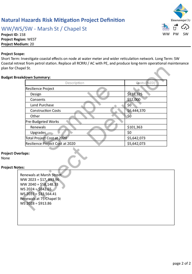


11 Public
Excluded Session
RESOLUTION TO
EXCLUDE THE PUBLIC
|
Recommendations
That the public be excluded from the following parts of
the proceedings of this meeting.
The general subject matter of each matter to be considered
while the public is excluded, the reason for passing this resolution in
relation to each matter, and the specific grounds under section 48 of the
Local Government Official Information and Meetings Act 1987 for the passing
of this resolution are as follows:
|
General subject of each matter to be
considered
|
Reason for passing this resolution in
relation to each matter
|
Ground(s) under section 48 for the
passing of this resolution
|
|
11.1 - Public Excluded Minutes of the
Urban Form and Transport Development Committee Meeting held on 9 June 2020
|
s7(2)(i) - the withholding of the information is
necessary to enable Council to carry on, without prejudice or disadvantage,
negotiations (including commercial and industrial negotiations)
|
s48(1)(a) - the public conduct of the relevant
part of the proceedings of the meeting would be likely to result in the
disclosure of information for which good reason for withholding would exist
under section 6 or section 7
|
|
11.2 – Item 9.5 – Arataki Bus Facility
– Attachments 1 and 2.
|
s7(2)(i) - the withholding of the information is necessary
to enable Council to carry on, without prejudice or disadvantage,
negotiations (including commercial and industrial negotiations)
|
s48(1)(a) - the public conduct of the relevant
part of the proceedings of the meeting would be likely to result in the
disclosure of information for which good reason for withholding would exist
under section 6 or section 7
|
|