|
 Urban
Form and Transport Development Committee Meeting Minutes Urban
Form and Transport Development Committee Meeting Minutes
|
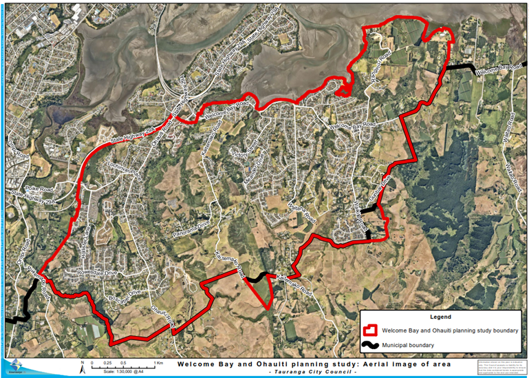
21 July 2020
|
|

|
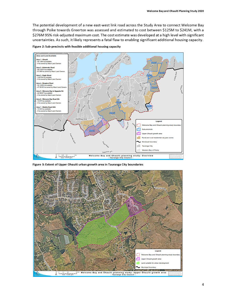
|
MINUTES
Urban Form and Transport Development Committee
Meeting
Tuesday, 21 July 2020
|
Order Of Business
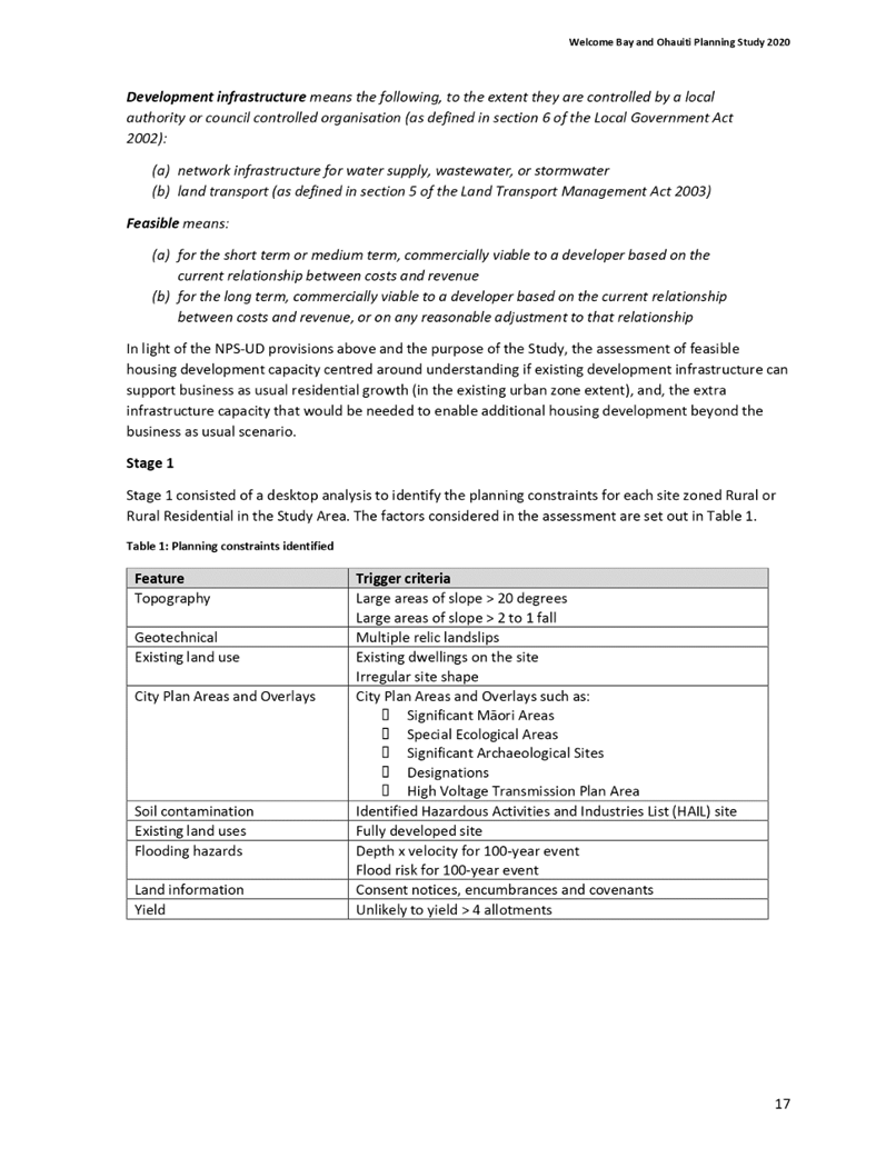
1 Apologies. 3
2 Public Forum.. 3
3 Acceptance of
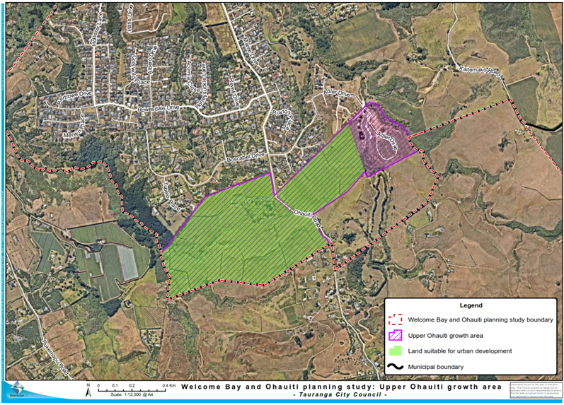
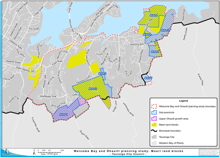
Late Items. 3
4 Confidential
Business to be Transferred into the Open. 3
5 Change to Order
of Business. 3
6 Confirmation of
Minutes. 4
6.1 Minutes
of the Urban Form and Transport Development Committee meeting held on 9 June
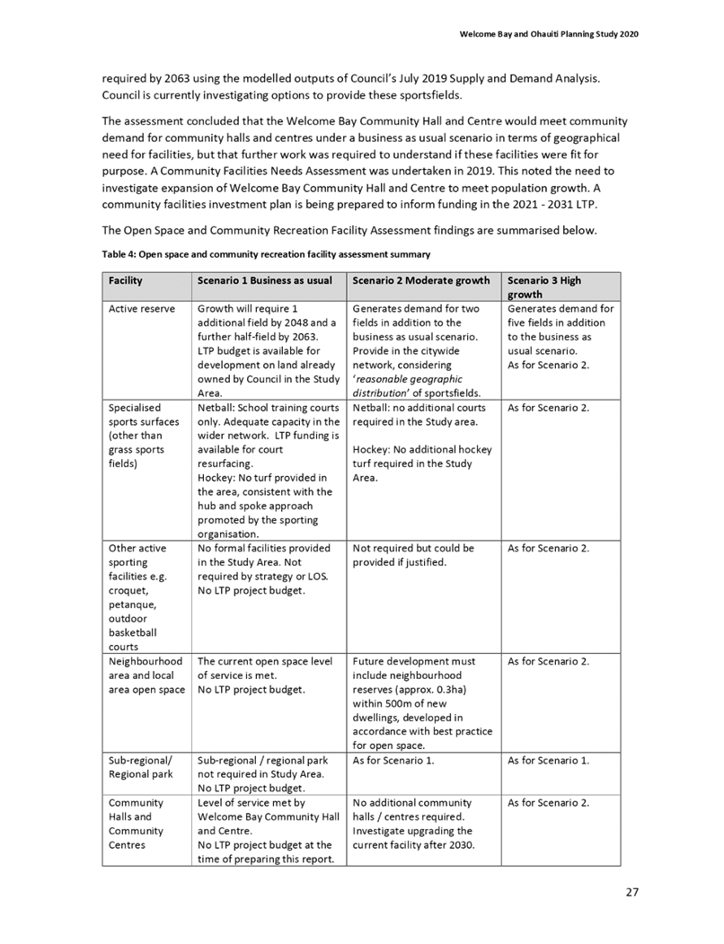
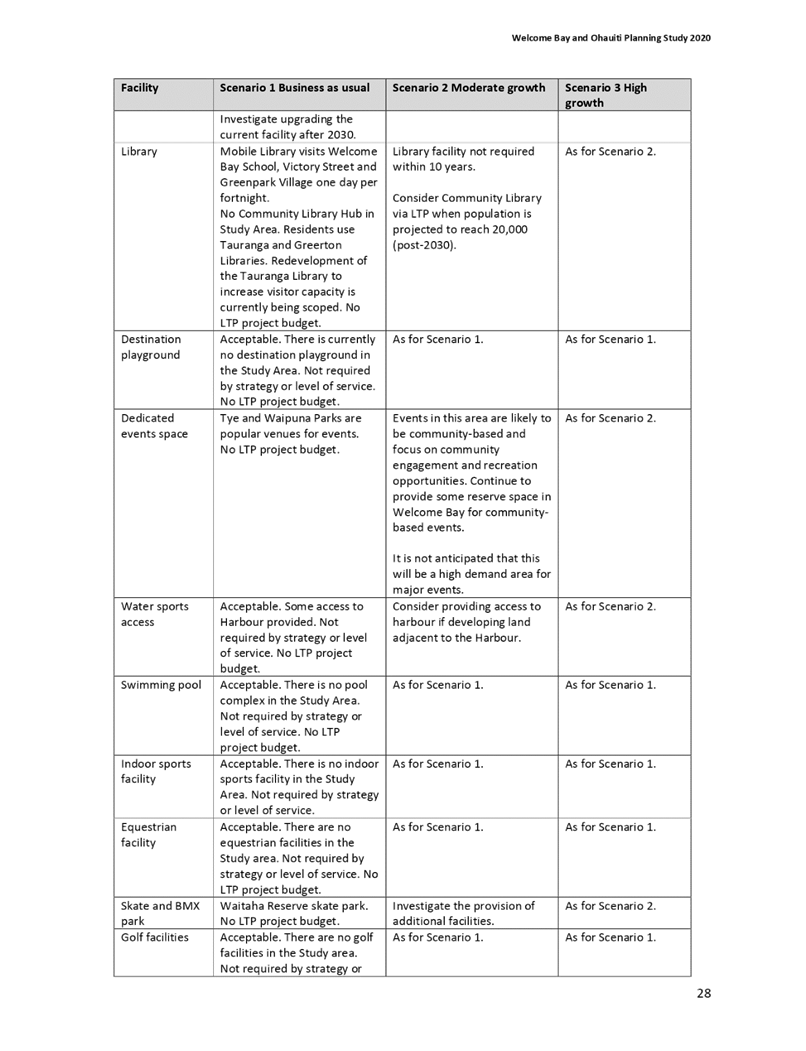
2020. 4
7 Declaration of
Conflicts of Interest 4
8 Deputations,
Presentations, Petitions. 4
8.1 Presentation
- Transport System Plan - presented by Neil Mason (TSP Project Director), Dean
Kimpton (Chair, TSP Governance Group), Alistair Talbot (Team Leader: Transport
Strategy and Planning) 4
8.2 Presentation
- Tauranga Transport Model - presented by Alistair Talbot (Team Leader:
Transport Strategy and Planning), Bala Arumugham (Principal Transport
Modeller), and Bruce Robinson (Principal Transport Advisor) 5
9 Business. 6
9.7 Infrastructure
Resilience Projects Proposed Scope Cost and Programme for LTP. 6
9.1 Tauranga
City Plan Review Project 7
9.6 Covid-19
Recovery (Fast-track Consenting) Bill 8
9.5 Arataki
Bus Facility. 9
11 Public Excluded Session. 10
11.1 Public
Excluded Minutes of the Urban Form and Transport Development Committee Meeting
held on 9 June 2020. 10
11.2 Arataki
Bus
Facility……………………….……………………………………………….10
9 Business
(continued) 10
9.5 Arataki
Bus Facility
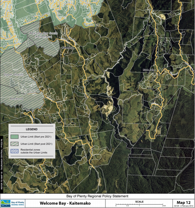
(continued)………………………………………………………….11
9.3 Transport
& Water Strategy and Planning Projects Progress Report - July 2020. 12
9.4 Emergency
Vehicle Access 17th Avenue to State Highway 2/29. 13
9.5 Arataki
Bus Facility
(continued)………………………………………………………….13
9.2 Te
Papa Spatial Framework and Housing Choice Plan Change - Shape your City
Engagement Summary and Response. 15
10 Discussion of Late Items. 16
MINUTES OF Tauranga
City Council
Urban Form and
Transport Development Committee Meeting
HELD AT THE Tauranga
City Council, Council Chambers, 91 Willow Street,
Tauranga
ON Tuesday, 21
July 2020 AT 9.30am
PRESENT: Cr
Larry Baldock (Chairperson), Cr Heidi Hughes (Deputy Chairperson), Mayor Tenby
Powell, Cr Jako Abrie, Cr Kelvin Clout, Cr Bill Grainger, Cr Dawn Kiddie, Cr
Andrew Hollis, Cr Steve Morris, Cr John Robson, Cr Tina Salisbury, and Te Pio
Kawe (Tangata Whenua representative)
IN ATTENDANCE: Marty Grenfell (Chief Executive),
Nic Johansson (General Manager: Infrastructure), Christine Jones (General
Manager: Strategy & Growth), Andy Mead (Manager: City & Infrastructure
Planning), Janine Speedy (Team Leader: City Planning), Carl Lucca (Programme Director: Urban Communities),
Alistair Talbot (Team Leader: Transport Strategy & Planning), Campbell
Larking (Team Leader: Planning Projects), Peter Siemensma (Senior Transport
Planner), Clare Cassidy (Principal Transport Planner), Karen Healey (Team
Leader: Strategic Property), Joel Peters (Team Leader: Engagement), Steve
Raynor (Resilience Specialist: Infrastructure & Urban Form), Robyn Garrett
(Team Leader: Committee Support), and Jenny Teeuwen (Committee Advisor)
1 Apologies
Nil
2 Public
Forum
Nil
3 Acceptance
of Late Items
Nil
4 Confidential
Business to be Transferred into the Open
Nil
5 Change
to Order of Business
The Chairperson advised
that the order of business could change during the meeting due to staff and external
presenters availability and to facilitate item 9.5 – Arataki Bus
Facility, being taken at 1pm.
6 Confirmation
of Minutes
7 Declaration
of Conflicts of Interest
Nil
8 Deputations,
Presentations, Petitions
|
8.1 Presentation
- Transport System Plan - presented by Neil Mason (TSP Project Director),
Dean Kimpton (Chair, TSP Governance Group), Alistair Talbot (Team Leader:
Transport Strategy and Planning)
|
|
A copy of the presentation for
this item can be viewed on Tauranga City Council’s website in the
Minutes Attachments document for this committee meeting.
|
|
Attachment
1
Presentation - Western Bay
of Plenty Transport System Plan
|
|
Key Points
·
The purpose of the Transport
System Plan (TSP) project was to translate the Urban Form and Transport
Initiative (UFTI) into implementation.
·
The TSP project was progressing well and
currently delivering ‘on programme’.
·
Steps one to four of the Transport System
Operating Framework (TSOF) development had been completed. Step five
was currently underway.
·
Key achievements included a strong
collaboration between partners, investment objectives being signed off by all
partners, an escalation process being established, and a successful full day optioneering
workshop with partners and specialists.
·
The very tight deadline of 1 September 2020
for the Regional Land Transport Plan (RLTP) review was a key challenge.
·
The next steps included completing TSOF Step
five, and working with partners to prepare RLTP and Long Term Plan (LTP)
inputs.
In Response to Questions
·
The TSP Governance Group was committed to
undertaking community engagement but what that might look like and how that
was presented was still being considered.
·
How the city develops and grows (its urban
form, how we want to live, learn, work and play) was an inherent input
to the TSP.
·
The financial gap in funding after
apportioning costs would require working with the Crown on innovative
solutions.
·
There was a need for a clear plan and programme
for transport capital projects going forward.
·
Decisions around the
RLTP submission would be made through the Regional Transport Committee.
·
State Highway 29A and connections to and from
it were high on the priority list.
|
|
8.2 Presentation
- Tauranga Transport Model - presented by Alistair Talbot (Team Leader:
Transport Strategy and Planning), Bala Arumugham (Principal Transport
Modeller), and Bruce Robinson (Principal Transport Advisor)
|
|
A copy of the
presentation for this item can be viewed on Tauranga City Council’s
website in the Minutes Attachments document for this committee meeting.
|
|
Attachment
1 Presentation
- Tauranga Transport Model
|
|
Key Points
·
The Tauranga Transport Model (TTM) was a key
tool to help understand the transport projects programme and the economics
associated with the projects.
·
The model is a long-standing partnership
activity with Bay of Plenty Regional Council (BOPRC), Western Bay of Plenty
District Council (WBOPDC), Tauranga City Council (TCC), and Waka Kotahi (New
Zealand Transport Agency – NZTA)
·
The model had strategic, operational, cycle,
public transport, freight and pedestrian components.
·
There was limited capability in the model for
ferry and rail modelling.
In Response to Questions
·
The TSP was using the model to help inform
some of its direction and activities.
·
Model design or strategy undertaken was
representative of the conditions of an average week day.
·
The model did not drive decisions but
supported what was trying to be done and would produce forecasts.
·
Most of the data sources were available,
however, some were confidential.
·
It was not common at a practitioner level to
have the model run backwards.
·
The model was recalibrated every five years,
generally post census. The next correction would happen at the end of
this year.
|
At 10.50am, the meeting adjourned.
At 11.05am, the meeting resumed.
At 11.05am, Mayor Tenby Powell left the
meeting.
Item 9.7 was taken next.
9 Business
|
9.7 Infrastructure
Resilience Projects Proposed Scope Cost and Programme for LTP
|
|
Staff Steve
Raynor, Resilience Specialist: Infrastructure & Urban Form
Campbell Larking, Team Leader:
Planning Projects
A copy of
the staff presentation for this item can be viewed on Tauranga City
Council’s website in the Minutes Attachments document for this
committee meeting.
|
|
Attachment
1
Presentation
- Resilience Project
|
|
Key points
·
The Infrastructure Resilience Project was
started in 2017.
·
Key hazards included liquification, harbour
erosion, sea level rise and flooding.
·
Some 300 mitigation projects had been
identified with total project costs estimated at $900 million.
·
94% of projects had a flooding
component. More than 50% of projects had four or more identified
hazards.
·
Sufficient information was now available to
begin discussions on project inclusion in the 2021/24 LTP.
·
Next steps included a technical prioritisation
process and reporting back on prioritisation outcomes.
·
Any project undertaken would deliver a
measured resilience benefit for the city.
In response to questions
·
There was no formal integration with the TSP
and TTM at this stage. The resilience projects were to be delivered
over time. The analysis of where hazard hot spots were would inform
infrastructure projects going forward.
·
The three waters infrastructure and roading
were the primary horizontal assets.
·
A list of the most serious hazard issues would
be available and considered as part of the LTP process.
|
|
Committee
Resolution UR4/20/2
Moved: Cr
John Robson
Seconded: Cr
Jako Abrie
That
the Urban Form and Transport Development Committee:
(a) Receives
the Infrastructure Resilience Projects Proposed Scope Cost and Programme for
LTP report.
(b) Notes
the progress made on the Infrastructure Resilience Project.
Carried
|
Item 9.1 was
taken next.
|
9.1 Tauranga
City Plan Review Project
|
|
Staff Janine
Speedy, Team Leader: City Planning
David Phizacklea, Project Manager
(Contractor): City Planning
Andy Mead, Manager: City &
Infrastructure Planning
A copy of
the staff presentation for this item can be viewed on Tauranga City
Council’s website in the Minutes Attachments document for this
committee meeting.
|
|
Attachment
1
Presentation
- City Plan Review Project
|
|
Key
points
·
There were legislative requirements to review the City Plan
every 10 years. There was also the National Planning Standards
requirement that the City Plan be notified by 2024.
·
Most councils, including regional councils, were going through
the same process now.
·
Four key drivers – key challenges and opportunities,
higher level planning documents, alignment with council strategies, and plan
usability and legal risk.
·
Four review options – city plan roll-over (bare minimum),
delay city plan review, comprehensive review, review incorporating existing plan
changes. Option 4 was recommended to meet Resource Management Act
requirements and address national planning standards and policy direction.
·
The review was an opportunity to engage positively with the
community, tangata whenua, stakeholders and developers.
·
An external consultant had been engaged to work with
TCC’s Communications team on a communications and engagement plan which
would be continuously revisited and reviewed throughout the project.
·
The project structure included governance, sponsors, project
direction, implementation and workstreams.
·
There were two governance options - through the Urban Form and
Transport Development Committee (UFTD) or a City Plan Sub-Committee.
Both options required full Council to approve the release of draft and
proposed new Tauranga City Plan.
·
Three risks in particular were highlighted - timing of the
Regional Policy Statement (RPS) review, proposed Resource Management Act
(RMA) reforms, and the project scope increasing and resourcing being
insufficient.
·
There was funding in the LTP for the project planning process,
however, this had been identified as being insufficient and it was proposed
that additional funding be provided to ensure all workstreams could be
carried out.
·
The total cost for the City Plan Review was estimated at $19.7
million, the majority had already been budgeted for.
In
response to questions
·
Alignment with WBOPDC’s plan review was as much as was
possible. There had been no conversation regarding one plan. It
was expected that both plans would look the same, but would have different
content.
·
TCC was currently within the RMA timeframe.
·
Governance costs included were for hearing submissions.
·
The NPS-Urban Development decision was due to be released on 23
July 2020.
·
It was intended that the principles for the wider community and
tangata whenua engagement be the same.
·
The UFTI work was being converted into a full spatial plan
which would include the concept of an iwi spatial plan layer, and this would
require engaging with iwi land trusts.
·
RMA accreditation would not be required to sit on the review
sub-committee but it would be helpful.
·
An open workshop for councillors on the city plan review would
happen sometime in September/October.
|
|
Committee Resolution UR4/20/3
Moved: Cr Larry Baldock
Seconded: Cr John
Robson
That the Urban Form and
Transport Development Committee:
(a) Endorse
the Tauranga City Plan Review – Project Plan (Attachment 1);
(b) Proceed
with Option 4 to undertake a comprehensive review, incorporating the existing
plan changes.
Carried
|
Item 9.6 was taken next.
|
9.6 Covid-19
Recovery (Fast-track Consenting) Bill
|
|
Staff Andy
Mead, Manager: City & Infrastructure Planning
Campbell Larking, Team Leader:
Planning Projects
Key
points
·
The Bill was in response to Covid-19 and to re-stimulate the
economy.
·
TCC was largely in support of the Bill, however some key issues
needed to be addressed. These were outlined in the report.
·
The Environment Committee would consider submissions and make
recommendations to parliament. The bill was expected to be passed into
law within the next one to two months.
In
response to questions
·
There was confidence that the right outcomes would be achieved
when using the fast-track consenting option.
·
The process for the Fast-track Bill and Special Housing Areas
were not dissimilar. The Fast-track Bill was broader as also dealt with
infrastructure and other types of assets, not just housing.
·
Any risk regarding Development Contributions would be in the
process, and not the legislation.
At 12.22pm,
Cr Dawn Kiddie left the meeting.
|
|
Committee Resolution UR4/20/4
Moved: Cr Jako Abrie
Seconded: Cr
Kelvin Clout
That the Urban Form and
Transport Development Committee receives the submission (Attachment 1) on the
Covid-19 Recovery (Fast-track) Consenting Bill lodged with the Environment
Committee on 20 June 2020.
Carried
|
At 12.30pm, the meeting adjourned.
At 1pm, the meeting resumed
At 1.00pm, Cr Dawn Kidde re-entered the meeting.
Item 9.5 was
taken next.
|
9.5 Arataki
Bus Facility
|
|
Staff Alistair
Talbot, Team Leader: Transport Strategy & Planning
Clare Cassidy, Principal Transport
Planner
Karen Healey, Team Leader: Strategic
Property
Joel Peters, Team Leader: Engagement
External David
Cosgrove, Divisional Development Manager, AMP
Bron
Healy, Principal Advisor - Regional Development, Bay of Plenty Regional
Council
Anthony Cross, Contractor, Bay of
Plenty Regional Council
A copy of
the staff presentation for this item can be viewed on Tauranga City
Council’s website in the Minutes Attachments document for this
committee meeting.
|
|
Attachment
1 Presentation -
Arataki Bus Facility
|
|
Key
points
·
Farm Street was currently the second busiest public transport
facility across the network, both from an origin of destination and transfer
perspective. The site was inadequate for its current and future use.
·
Many sites had been investigated. Two sites had been
shortlisted – the site currently used by St John Ambulance on Girven
Road and a location within the Bayfair site accessed from Farm Street.
·
Manoeuvring around the St John site was difficult.
Transport modelling on this site showed that delays would be created on
Girven Rd and Farm St, however this could be eased through traffic light
phasing.
·
Both sites were technically feasible but both had issues.
The Bayfair site did out-perform the St Johns site on some of the issues.
·
Both options required the development of a business case to be
eligible for National Land Transport Fund investment.
·
Both sites were likely to require a publicly notified resource
consent process.
·
As part of the engagement programme structure, a joint
stakeholder reference group was proposed which would include representatives
of all interest groups.
·
The next steps included further development of the design and
cost for one or both options and to progress with stakeholder and wider
public engagement.
·
Mr Cosgrove provided the following details for Bayfair.
Bayfair covered 42,500 square metres and had 6.5 million visitors
annually. There were 1937 carparks, 102 new carparks being added
recently. Bayfair believed that having the bus facility be part of
their site was eminently suitable. They were happy to work with Council
and were ready to go now.
In
response to questions
·
The Bayfair boarding numbers did not include the number of
passengers getting off the bus or the number of passengers already on the
bus.
·
There was a significant number of school children using the
facility travelling to and from school.
·
The integrated ticketing system being introduced next week
would provide better user number information from the Regional Council but
the information gathered over the first month was likely to be mixed.
·
The survey sample size was around 400.
·
An express service down Maunganui Rd was being considered as
part of the TSP project.
·
The stakeholder reference group would decide how best to
capture all interest groups. It was likely that Bayfair staff would be
represented on the group.
·
The St Mary’s site (across the road from the St John
site) had been previously discounted as being too small.
·
The draft AP included $100,000 for design costs.
Engagement costs would be in addition to that.
·
Bayfair staff numbers were around 1,200 maximum at any one
time.
At 1.40pm, Mayor
Tenby Powell re-entered the meeting.
At 1.40pm, the
discussion on this item was continued in the Public Excluded session.
|
11 Public
Excluded Session
RESOLUTION TO EXCLUDE
THE PUBLIC
|
Committee Resolution UR4/20/5
Moved: Cr Dawn Kiddie
Seconded: Cr
Kelvin Clout
That the public be excluded from the following parts of
the proceedings of this meeting, with the exception of Mr David Cosgrove,
Divisional Development Manager, AMP, as spokesperson for the owners of
Bayfair, and Mr Bron Healy, Principal Advisor Regional Development and Mr Anthony
Cross, Contractor, from Bay of Plenty Regional Council, as their specialist
knowledge of The Arataki Bus Facility report will assist in the discussion of
item 11.2 – Arataki Bus Facility.
The general subject
matter of each matter to be considered while the public is excluded, the
reason for passing this resolution in relation to each matter, and the
specific grounds under section 48 of the Local Government Official
Information and Meetings Act 1987 for the passing of this resolution are as
follows:
|
General subject of each matter to be
considered
|
Reason for passing this resolution in
relation to each matter
|
Ground(s) under section 48 for the
passing of this resolution
|
|
11.1 - Public Excluded Minutes of the
Urban Form and Transport Development Committee Meeting held on 9 June 2020
|
s7(2)(i) - the withholding of the information is
necessary to enable Council to carry on, without prejudice or disadvantage,
negotiations (including commercial and industrial negotiations)
|
s48(1)(a) - the public conduct of the relevant
part of the proceedings of the meeting would be likely to result in the
disclosure of information for which good reason for withholding would exist
under section 6 or section 7
|
|
11.2 – Arataki Bus Facility
|
s7(2)(i) - the withholding of the information is
necessary to enable Council to carry on, without prejudice or disadvantage,
negotiations (including commercial and industrial negotiations)
|
s48(1)(a) - the public conduct of the relevant
part of the proceedings of the meeting would be likely to result in the
disclosure of information for which good reason for withholding would exist
under section 6 or section 7
|
Carried
|
At 1.55pm, the meeting resumed in Open Council and continued
with Item 9.5 – Arataki Bus Facility
|
9.5 Arataki
Bus Facility
|
|
Committee MOTION
Moved: Cr Heidi Hughes
Seconded: Cr John
Robson
That the Urban Form and
Transport Development Committee:
a)
Receives the report “Arataki
Bus Facility”
b)
That TCC engage with Regional Council on a
concept of revised Governance and management arrangements with the purpose of
a more integrated approach to infrastructure and system planning for public
transport in Tauranga.
c)
Engage with a joint stakeholder reference
group and broader community on the multi-modal options and their implications
for transport facilities in the Arataki area.
d)
That information from the public transport
integrated ticketing system is used to inform decision making when it becomes
available.
Mayor Tenby Powell and Deputy Mayor Tina Salisbury were
required to attend another meeting. The Mayor requested that the Motion
be left to lie on the table until their return as both wanted to particpate
in the debate and decision for this item.
|
|
Committee Resolution UR4/20/6
Moved: Mayor Tenby
Powell
Seconded: Cr
Andrew Hollis
That the Motion for
item 9.5 – Arataki Bus Facilty be left to lie on the table until later
in the meeting when Mayor Tenby Powell and Deputy Mayor Tina Salisbury would
be present to participate in the debate and decision for this item.
Carried
|
At 2.35pm, Mayor Tenby Powell and Deputy Mayor Tina Salisbury
left the meeting.
At 2.38pm, Te Poi Kawe left the meeting.
Item 9.3 was taken next.
|
9.3 Transport
& Water Strategy and Planning Projects Progress Report - July 2020
|
|
Staff Andy
Mead, Manager: City & Infrastructure Planning
Alistair Talbot, Team Leader:
Transport Strategy & Planning
Key
points
·
Waters – the Nanako Stream stormwater consent to enable
development of the Kennedy Road area in Pyes Pa West (The Lakes) had now been
lodged with Bay of Plenty of Plenty Regional Council.
·
Transport –discussions with Waka Kotahi (NZTA) were
ongoing in respect of options and design elements of the Tauranga Northern
Link (TNL) project and the Tauriko business case.
·
The Urban Form and Transport Initiative (UFTI) project had been
completed.
In
response to questions
·
The Parking Strategy had been underway for a couple years and
was awaiting direction from UFTI to proceed. UFTI had now been
delivered and an options paper to consider the next steps for the Parking
Strategy would be bought back to an upcoming UFTD Committee meeting.
·
The ‘Point of Entry’ submitted to the NZTA
delegations approval committee for urgent safety improvements on Totara
Street, provided background information and referred to the point where the
investigation should begin.
·
Tasman Quay as an option for truck transport would be
considered as part of the Transport System Plan (TSP) project.
·
Modelling to show the effects on traffic volumes on Cameron
Road if there was an available connection to Takitimu Drive would be included
in the UFTI and TSP modelling.
|
|
Committee Resolution UR4/20/7
Moved: Cr Kelvin Clout
Seconded: Cr Jako
Abrie
That the Urban Form and
Transport Development Committee receives the Transport & Water Strategy
and Planning Progress Report – July 2020.
Carried
|
At 2.55pm, the meeting adjourned.
At 3.10pm, the meeting resumed.
Item 9.4 was taken next.
|
9.4 Emergency
Vehicle Access 17th Avenue to State Highway 2/29
|
|
Staff Peter
Siemensma, Senior Transport Planner
Alistair Talbot, Team Leader:
Transport Strategy & Planning
External Anne
Fosberry, Technical Director, Infrastructure, Aurecon
In response
to questions
·
The final design was not yet available from NZTA. An
emergency path between the bridge abutments would be challenging in terms of
acceleration and site lines.
|
|
Committee Resolution UR4/20/8
Moved: Cr Larry Baldock
Seconded: Cr Jako
Abrie
That the Urban Form and
Transport Development Committee:
(a)
Agrees to not progress with further investigation including design and
engagement on a potential 17th Avenue emergency vehicle access to
state highway at this stage.
(b) Agree
that the Cameron Road short-term multi-modal project will consider how
responses may support improved access for emergency vehicles (through use of
bus clearways; intersection priority) along Cameron Road.
(c) Agrees
Tauranga Transport Operating System SCATS investigation (through TTOC) will
consider the benefits of purchasing a module with an extension element for
emergency vehicles.
Carried
|
At 3.20pm, the meeting adjourned.
At 3.30pm, the meeting resumed.
At 3.30pm,
Mayor Tenby Powell and Cr Tina Salisbury re-entered the meeting.
The meeting
returned to Item 9.5 – Arataki Bus Facility
|
9.5 Arataki
Bus Facility
|
|
Committee MOTION
Moved: Cr Heidi Hughes
Seconded: Cr John
Robson
That the Urban Form and
Transport Development Committee:
(a)
Receives the report “Arataki
Bus Facility”
(b)
That TCC engage with Regional Council on a
concept of revised Governance and management arrangements with the purpose of
a more integrated approach to infrastructure and system planning for public
transport in Tauranga.
(c)
Engage with a joint stakeholder reference
group and broader community on the multi-modal options and their implications
for transport facilities in the Arataki area.
(d)
That information from the public transport
integrated ticketing system is used to inform decision making when it becomes
available.
|
|
Amendment
Moved: Cr Larry Baldock
Seconded: Cr
Kelvin Clout
That a clause (e) be
added:
(e) Agrees
to undertake the minimum work necessary to progress the concept design,
costing and planning for both shortlisted sites (Bayfair and St. John
Ambulance site off Girven Road) using funding included in the draft 2020/21
Annual Plan, to inform the engagement of the joint stakeholder reference
group and broader community.
In Favour: Mayor
Tenby Powell, Crs Larry Baldock, Jako Abrie, Kelvin Clout, Bill Grainger,
Steve Morris and Tina Salisbury
Against: Crs
Heidi Hughes, Dawn Kiddie, Andrew Hollis and John Robson
carried 7/4
The substantive motion as amended, was then put.
|
|
Committee Resolution UR4/20/9
Moved: Cr Heidi Hughes
Seconded: Cr John
Robson
(a)
Receives the report “Arataki
Bus Facility”
(b)
That TCC engage with Regional Council on a
concept of revised Governance and management arrangements with the purpose of
a more integrated approach to infrastructure and system planning for public
transport in Tauranga
(c)
Engage with a joint stakeholder reference
group and broader community on the multi-modal options and their implications
for transport facilities in the Arataki area.
(d)
That information from the public transport
integrated ticketing system is used to inform decision making when it becomes
available.
(e)
Agrees to undertake the minimum work necessary
to progress the concept design, costing and planning for both shortlisted
sites (Bayfair and St. John Ambulance site off Girven Road) using funding
included in the draft 2020/21 Annual Plan, to inform the engagement of the joint stakeholder reference group and
broader community.
Carried
|
Item 9.2 was taken next.
|
9.2 Te
Papa Spatial Framework and Housing Choice Plan Change - Shape your City
Engagement Summary and Response
|
|
Staff Janine
Speedy, Team Leader: City Planning
Andy Mead, Manager: City &
Infrastructure Planning
Carl Lucca, Programme Director: Urban Communities
A copy of
the staff presentation for this item can be viewed on Tauranga City
Council’s website in the Minutes Attachments document for this
committee meeting.
|
|
Attachment
1
Presentation
- Te Papa and Housing Choice Plan Change
|
|
Key points
·
Engagement under the banner “Shape your City”
occurred over 7 April to 19 May 2020.
·
Feedback received was generally supportive. A detailed
overview of the feedback received was available in Attachments one, two and
three.
·
Two key themes were identified – the geographical
extent of the Te Papa Spatial Plan, and how to enable detached versus
attached housing through the rules framework.
·
Key view shafts agreed with tangata whenua were already in the
City Plan and allowed for the sight of Mauao for marae.
·
Feedback received regarding Merivale included that Merivale be
included in the ’increased housing choice area’; that work
continued to provide housing, public places, facilities and services; and
that more social housing in Merivale was firmly opposed.
·
It was recommended that two to three storey apartments,
terraces and duplexes be provided through Plan Change 26, higher density
options be investigated in partnership with key stakeholders, and LTP and
partner funding to support a liveable and connected Merivale be confirmed.
·
The purpose of the Housing Choice Plan
Change was to help address residential development capacity constraints,
enable more housing choice, reduce pressure on urban expansion, and support
good quality design and amenity outcomes.
·
An options analysis had been undertaken for both the Te Papa
Spatial Framework – Te Papa Housing overlay geographic extent and the
Plan Change – Housing Choice.
·
For the Te Papa Spatial Framework – Te Papa Housing
overlay geographic extent, option one was recommended.
·
For Plan Change 26 - Housing Choice, option four was
recommended.
In
response to questions
·
There would not be an opportunity outside of this Plan Change
26 to do anything further regarding rezoning ahead of the City Plan review.
·
More time would be needed to further investigate adding a
separate Merivale residential zone.
·
Improvements for Merivale were
programmed to start in the second half of the next RLTP and LTP with
investigations starting in 2022-2023.
·
The MPS-UD document was due out on Thursday 23 July and this
would be worked through to align the plan change. In terms of
carparking requirements, there would be additional work but this had been
planned for and would be carried out within the required timeframes.
·
Submissions to include, or not include,
Merivale could still be made during the formal plan change process.
·
Specific elements or issues of the plan change would be
workshopped with councillors.
·
Both people density and dwellings density would be taken into
account.
At 4.47pm, Cr Andrew
Hollis left the meeting.
At 4.51pm, Te Pio
Kawe re-entered meeting.
The
recommendations were taken in parts.
|
|
Committee Resolution UR4/20/10
Moved: Cr Larry Baldock
Seconded: Cr Dawn
Kiddie
That the Urban Form and
Transport Development Committee:
(a)
Receive Shape Your City engagement reports (Attachment 1 and
Attachment 2);
In Favour: Mayor
Tenby Powell, Crs Larry Baldock, Heidi Hughes, Jako Abrie, Kelvin Clout, Bill
Grainger, Dawn Kiddie, Steve Morris, John Robson and Tina Salisbury
Against: Nil
carried 10/0
(b)
Endorse Option 1 on the Te Papa Housing Overlay geographic extent to
be proposed through the Te Papa Spatial Framework and Plan Change 26 –
Housing Choice;
In Favour: Mayor
Tenby Powell, Crs Larry Baldock, Kelvin Clout, Bill Grainger, Dawn Kiddie,
Steve Morris, John Robson and Tina Salisbury
Against: Crs
Heidi Hughes and Jako Abrie
carried 8/2
(c)
Endorse Option 4 on the built form options to be proposed through Plan
Change 26 – Housing Choice.
In Favour: Mayor
Tenby Powell, Crs Larry Baldock, Heidi Hughes, Jako Abrie, Kelvin Clout, Bill
Grainger, Dawn Kiddie, Steve Morris, John Robson and Tina Salisbury
Against: Nil
carried 10/0
Carried
|
10 Discussion
of Late Items
Nil
The meeting closed at 5.15pm.
The minutes of this meeting were confirmed at the Urban
Form and Transport Development Committee meeting held on 1 September 2020.
...................................................
CHAIRPERSON
8 Business
8.1 Welcome
Bay and Ohauiti Planning Study 2020
File
Number: A11601682
Author: Steve
Tuck, Policy Planner
Authoriser: Christine
Jones, General Manager: Strategy & Growth
Purpose of the Report
1. To
inform the Urban Form and Transport Development Committee about the findings
and recommendations arising from completion of the Welcome Bay and Ohauiti
Planning Study 2020 (Study).
2. An
abridged version of the Study (without the lengthy supporting appendices) is
included as Attachment 1 to this report. The Study and all of the associated
appendices can be viewed on the Tauranga
City Council website.
|
Recommendations
That the Urban Form and Transport Development Committee:
(a) Receives
the report titled Welcome Bay and Ohauiti Planning Study 2020;
(b) Adopts
the report and recommendations set out in the Welcome Bay and Ohauiti
Planning Study 2020 (Attachment 1) as follows:
(i) Do
not proceed with structure planning for additional urban development in the
Welcome Bay area because of transport constraints and costs;
(ii) Subject
to positive outcomes of discussions with relevant landowners and preliminary
structure planning investigations, approve completion of a structure plan and
the rezoning of the Upper Ohauiti growth area that is within the current Tauranga
City boundary through the Tauranga City Plan Review project;
(iii) Commence
engagement with Māori Land Trusts in the Study
Area in relation to future land use options as part of the Tauranga City
Plan Review project;
(iv) Examine
options to improve transport choice, connectivity and support predictable
travel times in the Study Area through the Transport System Plan and
structure planning of Upper Ohauiti;
(v) Seek
to address the undersupply of commercial land in the Study Area through the
Tauranga City Plan Review project;
(vi) Continue
working with the Ministry of Education on planning for a new primary school
in the Ohauiti area;
(vii) Continue
to advocate to the Ministry of Education for better Year 7-13 schooling
options within the Study Area to reduce pressure on the transport network at
peak periods, noting that the Ministry of Education has other priorities for
secondary schooling and is not currently planning for a secondary school in
the Study Area;
(viii) Continue
to investigate the provision of new sportsfields in Ohauiti to meet existing
demand; and
(ix) Investigate
options for the upgrade or redevelopment of the Welcome Bay Community Hall
and Centre as part of the Community Facilities Investment Plan being prepared
for Council’s Long-Term Plan 2021 - 2031 and 30 Year Infrastructure
Strategy with a view to future improvement of this facility, potentially
around 2030.
|
Executive Summary
3. The
Study was initiated in June 2017. The purpose of the Study was to:
(a) Identify
gaps and capacity constraints within the network for commercial, community
infrastructure, education, transport, three waters within the Study Area and
the investment required to support housing growth;
(b) Ascertain
if the Study Area could absorb residential development capacity beyond business
as usual by rezoning land in the Rural and Rural Residential zones; and
(c) Identify
whether additional population growth and housing development compared to
business as usual growth could justify investment to provide better local
services and facilities to the Study Area communities and reduce reliance on
services and facilities located elsewhere.
4. The
main drivers behind the Study were:
(a) An
emerging understanding that the planning of the Study Area in the 1990’s
did not optimise the community’s access to employment, education,
commercial centres or community facilities and did not enable effective
transport connectivity to/from and around the Study Area;
(b) Enquiries
in 2017 to develop housing in the Study Area through the (now repealed) Special
Housing Areas legislation; and
(c) Forecast
shortfalls in urban development capacity, notwithstanding the capacity to be
realised in Tauranga’s greenfield urban growth areas and housing
intensification areas.
5. The
Study Area referred to in this report is shown in Figure 1 (which, with other
maps, is provided as Appendix 1 to the main Study report available on Council’s
website). The Study Area was limited to land within the Tauranga City
Council (TCC) jurisdictional boundary except for one site in the Western Bay of
Plenty District (WBOP) contiguous with the TCC boundary that had previously
been suggested as a Special Housing Area.
Figure 1:
Study Area
6. Seven
sub-precincts of the Study Area that may be feasible for rezoning and
additional housing development were identified via a desktop assessment. Then,
the capacity of infrastructure and facilities to service those sub-precincts
was assessed against three population growth scenarios - business as usual
growth, moderate growth and high growth. Infrastructure modelling and
assessments were undertaken for the following:
(a) Three
waters services (potable water supply, wastewater and stormwater);
(b) Transport
infrastructure;
(c) Community
infrastructure and education; and
(d) Commercial
centre development.
7. The
modelling and assessments of three waters, community infrastructure, education
and commercial centres identified that while there are some capacity issues,
there are no fatal flaws to the delivery of upgrades required to accommodate
additional housing capacity.
8. However,
the Study found that medium and high growth housing scenarios in the Study Area
appear unfeasible, except in the Upper Ohauiti urban growth area (Upper
Ohauiti). This conclusion largely derives from the costs of developing road
infrastructure to cope with the additional traffic generated by more housing.
The current traffic congestion in the Welcome Bay Road area, which includes
buses using Welcome Bay Road, would be worsened by the medium and high growth
housing scenarios.
9. The
potential development of a new east-west link road across the Study Area to
connect Welcome Bay through Poike towards Greerton was assessed and estimated
to cost between $125M to $214M, with a $276M 95% risk-adjusted maximum cost.
The cost estimate was developed at a high level, with significant
uncertainties. As such, it seems to represent a fatal flaw to the ability to
enable any significant additional housing capacity in the Study Area.
Additionally, it was found that a road project of this nature would be subject
to numerous other risks and constraints including land acquisition in general
and Māori title, encroachments onto several significant public reserves
and parks, uncertainty around the grant of approvals to authorise adverse
effects on land with recognised ecological and heritage values and the effects
of road structures in displacing flood flows onto other land.
10. Pursuant
to the Bay of Plenty Regional Policy Statement (RPS) and the SmartGrowth
Settlement Pattern 2013, Upper Ohauiti is within the urban limits and
signalled for urban growth post 2021. This provides for Upper Ohauiti to be
structure planned post-2021 and for development to commence from 2026.
Structure planning investigations for Upper Ohauiti are recommended to be
progressed through the forthcoming City Plan Review project, in line with the
indicative RPS sequencing as constraints to further urban development in
Ohauiti are considered to be lesser than in Welcome Bay based on the findings
of this Study.
11. The
Kaitemako urban growth area (Kaitemako) is also identified in the RPS with
similar indicative timing for planning and development sequencing. However, the
only way in and out of that growth area is via the Kaitemako Road and Welcome
Bay Road. The development of Kaitemako would therefore be subject to the
constraints and vulnerabilities of that transport network.
12. In
comparison, Upper Ohauiti is less constrained by access. It is linked via
Ohauiti Road and Poike Road to State Highway 29A in two locations and to
Welcome Bay Road / Turret Road. There may also be opportunities
identified through structure planning or other process for connection to Oropi
Road in future.
13. Although
it is not recommended to progress urbanisation of other parts of Welcome Bay in
the same way as Upper Ohauiti, a recommendation arising from the Study is to
commence investigations and engagement around other land use options through
the City Plan Review, particularly for multiple-owned Māori land.
14. The
other recommendations arising from the Study are to continue planning and
investment to support and where appropriate, enhance the delivery of services
and facilities to the existing Welcome Bay and Ohauiti communities.
Background
Project stages
15. The
Study was undertaken in three stages.
16. Stage
1 identified the planning constraints for each site zoned Rural or Rural
Residential in the Tauranga City Plan (City Plan).
17. Stage
2 used the information from Stage 1 to assess the feasibility of each site for
urban development and sites were mapped into the following categories:
(a) Green:
Site is feasible for urban development;
(b) Orange:
Site is likely feasible for urban development, but feasibility will need to be
confirmed by further site-specific investigations; and
(c) Red:
Site is unlikely to be feasible for urban development.
18. The
outcomes of the Stage 2 assessment are shown in Figure 2 below. Figure 2 shows
the configuration of land assessed as feasible, likely feasible and unfeasible
for urban rezoning and development.
19. Figure
2 also shows the extent of seven sub-precincts comprised of feasible and likely
feasible land. The extents of those sub-precincts are shown with blue hatching.
The Upper Ohauiti growth area is shown in Figures 2 and 3.
Figure
2: Development feasibility assessment
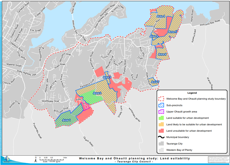
Figure
3: Upper Ohauiti urban growth area extent within Tauranga City boundaries
20. The
combined approximate housing yield of the sub-precincts was calculated using
the RPS density of 15 dwellings per hectare (noting that the actual yield of
development could be different to this). Then, three housing growth scenarios
were developed to inform modelling and technical assessments as follows:
(a) Scenario
1 Business as usual: Existing housing, plus the yield from the remaining
capacity of the current urban zones that has yet to be developed. No further
land would be rezoned from rural to urban.
(b) Scenario
2 Moderate growth: Scenario 1 plus urban rezoning of 122 hectares of land in
general title. This assumes that no multiply owned Māori land (Figure 3)
is rezoned.
(c) Scenario
3 High growth: Scenario 2 plus urban rezoning of 108.8 hectares of multiply
owned Māori land.
21. The
yields and geographic locations of the feasible sub-precincts and Māori
land parcels are described in Table 1 and Figure 4 below.
Table 1: Housing growth scenarios
|
Scenario
|
Rezoning
|
2018 dwelling count
|
2063 dwelling count
|
Yield
|
|
General land
|
Māori land
|
|
Scenario 1: Business as usual
|
None
|
None
|
6,322
|
7,669
|
1,347
|
|
Scenario 2: Moderate growth
|
122 ha
|
None
|
6,322
|
9,459
|
3,137
|
|
Scenario 3: High growth
|
122 ha
|
108.8 ha
|
6,322
|
11,062
|
4,740
|
Figure
4: Māori land parcels
22. Stage
3 of the Study involved modelling and high level assessments and investigations
of the capacity of three waters, transport, community infrastructure, education
facilities and commercial centres to accommodate housing growth. The outcomes
of Stage 3 are summarised below.
Three waters infrastructure
23. Modelling and assessment of the three
waters infrastructure (water supply, wastewater, and stormwater services) did
not identify any fatal flaws to servicing additional population growth.
24. The
water supply network in the Study Area was modelled for urban growth to the
year 2043. Upgrades (estimated to cost approximately $5.9M) would provide for
network capacity to accommodate the medium and high growth scenarios. The
modelling analysis of water supply is provided as Appendix 4 to the main Study
report available on Council’s
website.
25. The
wastewater network was found to require upgrades estimated at $3.9M to
accommodate the business as usual scenario. The cost estimates to accommodate
the housing growth of Scenarios 2 and 3 were from $12.1M to $29.9M, depending
on which growth scenario and upgrade option were adopted. The modelling and
analysis for the wastewater network is provided as Appendix 5 to the main Study
report available on Council’s
website.
26. The
stormwater network would require extensions and upgrades to accommodate flows generated
by additional growth. The identified developable sub-precincts are mostly
higher in the respective catchments than established urban parts of the Study
Area. Therefore, additional development would need to integrate methods to
manage downstream effects, in a context of numerous overland flow paths and
watercourses and steep topography. This would likely require on and off-site
stormwater management systems to manage water quality and to avoid creating
hazardous flow velocities and depths downstream.
27. Although
it is considered that stormwater management could be integrated into additional
housing development in the various identified sub-precincts, the combination of
stormwater management requirements and other features would require significant
design attention on a site by site basis to understand individual site
feasibility as well as the cumulative effects of site and sub-precinct
development on stormwater management in the wider catchment(s). The analysis
for the stormwater network is provided as Appendix 6 to the main Study report
available on Council’s
website.
Community infrastructure
28. A
desktop Open Space and Community Recreation Facility Assessment was undertaken
for the Study Area in January 2019. The assessment is provided as Appendix 10
to the main Study report available on Council’s
website. The assessment is summarised as follows:
(a) In
the business as usual scenario, 1.5 additional grass sports fields are needed
in the Study Area by 2048. Council’s Long Term Plan 2018 – 2028
provides for sufficient additional sports field development to satisfy this
demand. Scenarios 2 and 3 would require five to seven extra grass sports fields
to be provided based on current levels of service. These would have to be
sourced from the wider network as no suitable land currently in Council’s
ownership is available in the Study Area. Site selection and land acquisition
to satisfy the demand generated under Scenarios 2 and 3 would likely be
challenging as site options are highly constrained.
(b) In
Scenarios 2 (moderate growth) and 3 (high growth), the provision of a skate/BMX
park and a community library in the Study Area should be investigated.
(c) Based
on Council’s existing assets and levels of service, the increased housing
capacity under Scenarios 2 and 3 would not require investment into specialised
sports facilities (netball, hockey, squash, basketball, swimming pools),
sub-regional parklands, destination playgrounds, golf courses or equestrian
facilities.
29. The
level of service for community halls and centres in the Study Area is currently
met by the Welcome Bay Community Hall and Centre. This was reviewed in 2019 as
part of the Study. The review noted that while the Community Hall and Centre
meets the level of service standard, there is a need to investigate expanding
the Welcome Bay Community Hall and Centre to respond to population growth. A community
facilities investment plan is being prepared to inform funding in the 2021-2031
LTP.
Schooling
30. Council staff liaised with
representatives from the Ministry of Education (MoE) to understand the
MoE’s planning for schools in the Study Area. The MoE advised that:
(a) 1,989
Year 1-8 students live in the Study Area. The MoE is investigating the
potential development of a new primary school in Ohauiti by approximately 2025.
The MoE considers Year 1 – 8 students in Welcome Bay to be adequately
serviced by the existing Selwyn Ridge School, Welcome Bay School and Tauranga
Waldorf School;
(b) 1,026
Year 9 - 13 students live in the Study Area. These students attend secondary
schools that are nearly at capacity (99% utilisation). The MoE advised that it
is making significant investments to increase the capacity of existing
secondary schools and furthermore, intends to develop a new secondary school in
the Western Corridor (Pyes Pa/Tauriko).
(c) Based
on the three housing growth scenarios for the Study Area, the MoE advised that:
(i) Except
in Scenario 3 (high growth) the development of a primary school in Ohauiti
around 2025 will secure schooling capacity for Year 1 – 8 students until
2043.
(ii) The
MoE is not planning to develop a new secondary school in Welcome Bay. There are
limited suitable sites and furthermore, shifting student enrolments from the
Study Area to a new school could affect the viability of the secondary schools
that currently service those enrolments. There is a capacity shortfall for Year
9 - 13 students in all three population growth scenarios. However, the MoE
notes that it plans to build an additional secondary school in Tauranga South
(Pyes Pa / Tauriko). This will reduce out of zone enrolments at Tauranga Boys
College, making space available for students from the Study Area.
31. Council
staff will continue to work with the MoE to facilitate schooling capacity as
needed. The MoE’s memorandum detailing the education needs in the Study
Area is provided as Appendix 9 to the main Study report available on Council’s
website.
Commercial centre and supermarket development
32. On
12 March 2019, Council staff reported a feasibility assessment of commercial
centre development to the Urban Form and Transport Development committee
(UFTD). A copy of that feasibility assessment is provided as Appendix 7 to the
main Study report available on Council’s
website.
33. The
commercial centres assessment reviewed the factors (including consumer demand,
location and site criteria) that contribute to commercial centre feasibility.
It identified the likely centre typology and scale that would be feasible given
the characteristics of the Study Area.
34. Due
to the disconnected character of the Study Area and the lack of large, flat
sites at the front of the catchment, there is no central site to service both
Welcome Bay and Ohauiti. Therefore, the assessment noted that separate
commercial centre developments in each catchment might be feasible,
particularly if supported by additional population growth.
35. The
commercial centre assessment recommended that Council should enable a
neighbourhood-scale centre (being approximately 10,000m² of retail and
commercial floorspace, including an approximately 2,000m² supermarket). If
a centre of this size is not achievable, the assessment recommended that
smaller convenience centres (up to about 3,000m²) on collector roads could
be a “next best” option to respond to commercial demand. The
assessment shortlisted four sites that might support a neighbourhood
centre-scale commercial development.
36. After
receiving the commercial assessment in March 2019, the UFTD committee resolved
that Council staff would pursue discussions about a supermarket and commercial
centre development separately to the Study.
37. It
is recommended that further investigations into how Council can assist to
address the identified shortfall in commercial land be progressed through the
City Plan Review.
38. The
absence of commercial facilities continues to concern the Study Area’s communities.
The 2020 Vital Update surveys record that respondents in the Welcome Bay,
Hairini and Maungatapu survey area and the Poike, Oropi, Greerton and Ohauiti
survey area respectively rated “more cafes / supermarkets / community
hubs / facilities / services” as the first and third priorities for
change in the area respectively.
Transport infrastructure
39. Transport
modelling and analysis were undertaken in two steps. The first step modelled
the three population growth scenarios and then modelled three roading options
to increase transport system capacity to cope with the additional traffic
volumes generated by growth. The three roading options modelled were:
(a) Option
1: Bypassing the most congested part of Welcome Bay Road;
(b) Option
2: Developing an east-west link road through the middle of the Study Area; and
(c) Option
3: Developing a ring road around the south of the Study Area.
40. The
transport modelling revealed that even under the business as usual growth
scenario, traffic congestion would continue to occur. The modelling of the
three roading options revealed that the east-west link road through the Study
Area (Option 2) performed best in accommodating the increased traffic volumes
generated by housing growth.
41. It
is noted that Option 2 did not completely resolve congestion issues. For all
options modelled, peak-time traffic congestion would continue to affect the
network. The transport modelling of the three growth scenarios and three
roading options is provided as Appendix 2 to the main Study report available on
Council’s
website.
42. The
second step in the transport modelling and analysis was a high-level
feasibility assessment of Option 2 (i.e. the best performing option). The
feasibility assessment was based on an east-west link road bisecting the Study
Area between Oropi Road / State Highway 29A (SH29A) and Welcome Bay via Poike
Road.
43. The
engineering and planning feasibility of an east-west link road would rely on
the construction of bridges, culverts and flyovers to traverse the hilly
terrain. All of the assessed corridor alignment options presented key
feasibility risks. The main risks related to the mitigation of adverse
environmental effects and land acquisition. Environmental effects included the
displacement of flood flows onto land near the western alignment options, the
destruction of significant cultural and environmental value, and encroachment
onto/bisecting of, public reserves and sportsgrounds. Land acquisition risks
would arise from the complexity of acquiring land in public, private and
Māori tenures.
44. A
high level cost estimate of $125M to $214M was provided, with a $276M 95%
risk-adjusted maximum cost. The cost estimate is replicated below. Even though
the estimate is high level, it is likely to be prohibitive, especially
considering that this option does not resolve all of the congestion issues
identified in the transport modelling.
Table 2: High-level east-west link road cost estimates
|
Location
|
Length
(km)
|
Project expected estimate cost
($ Million)
|
95% risk adjusted maximum cost
($ Million)
|
|
Welcome Bay to Poike Road: eastern corridor
|
2.15
|
$85
|
$98 to $102
|
|
Poike Road to SH29A: central corridor
|
1.35
|
$9.7
|
$14.7
|
|
SH29A to Oropi Road: western corridor (south – SH29A)
|
2.0
|
$31 to $120
|
$160
|
|
Total
|
5.5
|
$125 to $214
|
$272 to $276
|
45. Aside
from the cost, an east-west link road could prove unfeasible due to approval
risks and uncertainties deriving from the City Plan, the RPS and Regional
Plans, National Environmental Standards and National Policy Statements. Certain
approval risks could not be quantified, because the final form of various
national-level planning instruments being developed by the Ministry for
Environment was unknown. This uncertainty was additional to the typical
uncertainties associated with forecasting the planning context at some future
time when an approvals process is initiated.
46. Given
the risk and uncertainty of the resource consenting approval pathway, the
assessment recommended a road designation process as a more appropriate
pathway. However, a designation process also involves risk and uncertainty
deriving from the findings of, and any mitigation conditions recommended by,
the technical assessments that would be prepared in support of a Notice of
Requirement for a designation.
47. The
assessment focussed on high-level planning and engineering feasibility
questions. The wider strategic economic benefits and a business case for a link
road were not assessed. Community support for, or opposition to, a link road
was not canvassed.
48. All
alignment options would require complex acquisition processes involving land in
general title, Māori land and public reserves. The assessment noted that
other solutions may be better value than a link road proposition.
49. The
high-level cost estimates and risk profile associated with developing an
east-west link road across the Study Area are therefore likely to be fatal
flaws. The feasibility assessment is provided as Appendix 3 to the main Study
report available on Council’s
website.
50. The Western Bay of Plenty Transport
System Plan (TSP) project is currently developing a System Operating Framework
(SOF) to identify the location, type, timing and significance/scale of the
operating gaps impacting the transport network. The early investigations
undertaken to date have unsurprisingly identified operating gaps (e.g. lack of
mode choices and accessibility to key social and economic opportunities, and
congestion) impacting the Welcome Bay transport network and extending through
to State Highway 29A, Turret Road and Fifteenth Avenue.
51. Although
the SOF is still in development, the current early investigations are likely to
be confirmed. This would support further analysis of the operating gap through
the development of a business case with transport partners like the Bay of
Plenty Regional Council and Waka Kotahi New Zealand Transport Agency. The
business case (which is still to be agreed and scoped as part of the TSP
project) would focus on addressing the operating gaps identified in the SOF.
52. The
vulnerability of Welcome Bay Road to natural hazards is a further matter
relevant to consideration of moderate or high population growth scenarios as
well as for the existing community. This road is the primary transport and
utilities route servicing Welcome Bay. The hilly landform has prompted the
section of Welcome Bay Road between James Cook Drive and Waitaha Road to be
aligned along the shoreline. The shoreline is at a low elevation and is subject
to flooding, sea level rise, landslip and liquefaction hazards.
53. The
concentration of infrastructure in a corridor intersected by multiple hazards
increases the assets’ vulnerability. For example, a landslip could cause
major water supply and wastewater service disruptions. If
additional population growth (compared to the business as usual scenario) were
to be enabled in Welcome Bay, the reliance on vulnerable infrastructure would
increase the community’s exposure to risk.
54. The
vulnerability of this part of Welcome Bay Road was identified by
Council’s resilience project. While mitigation projects have been scoped
and costed for consideration in Council’s Long Term Plan and 30-year
infrastructure plan, the scheduling of these projects is yet to be confirmed.
55. However,
Upper Ohauiti is less constrained, because it is not reliant on a single road
connection for transport or infrastructure connectivity. Ohauiti is linked via
Ohauiti Road and Poike Road to State Highway 29A in two locations and to
Welcome Bay Road / Turret Road. There may also be opportunities
identified through structure planning or other process for connection to Oropi
Road in future.
56. A
survey of Welcome Bay, Hairini and Maungatapu residents for the Vital Update
2020 revealed respondents concerns about transport issues. The second, third,
fifth and seventh most highly ranked responses to the question “What is
one thing people would change about Welcome Bay, Harini and Maungatapu?”
related to traffic congestion, roading quality, public transport provision and
walkway/cycleway provision.
57. Respondents
to the Vital Update for Poike, Oropi, Greerton and Ohauiti responded to the
question “What is the one thing people would change about Poike, Oropi,
Greerton and Ohauiti?” similarly to the Welcome Bay residents. The same
issues were identified but with higher rankings for three, with traffic
congestion (first), roading quality (second), public transport provisions
(fifth) and walkway/cycleway provision (sixth).
Strategic / Statutory context
58. The
National Policy Statement for Urban Development 2020 (NPS-UD) was gazetted on
20 August 2020, replacing the National Policy Statement on Urban Development
Capacity 2016. The NPS-UD seeks to improve land supply, development capacity
and infrastructure and reduce the cost of urban land. It requires local
authorities to ensure their plans provide enough urban development capacity to
meet short, medium and long term demand for residential and business
development. Council must give effect to the NPS-UD pursuant to the Resource
Management Act 1991 (RMA).
59. The
RPS provides regional policy context to the RMA’s national directions,
for example:
(a) Seeks
a 3:1 split between greenfield growth and urban intensification (Policy UG
15B);
(b) Future
urban growth is, at a high level, directed to the locations, timing and
sequencing stated in RPS Appendices C, D and E (Policies UG 5A and UG 6A); and
(c) Comparative
monitoring of forecast and actual urban growth patterns (Method 14) and
coordinated structure planning of large-scale land use change (Method 16) are
required to inform future urban growth.
60. Guidance
at the Western Bay of Plenty sub-regional level is provided by the Urban Form
and Transport Initiative (UFTI). The UFTI final report was endorsed by Council
and the SmartGrowth partner Councils at the combined SmartGrowth Leadership
Group meeting on 1 July 2020. The UFTI final report sets out a “Connected
Centres” land use and transport programme to guide future investment
decisions. The programme is focussed on enabling housing growth (an estimated
35,400 dwellings to 2050) and multi-modal transport systems connecting
settlements throughout the Western Bay of Plenty sub-region. It is noted that
Table 7 of the UFTI final report states that the potential for housing growth
in the Study Area is limited by complex land ownership patterns and
infrastructure constraints.
Upper Ohauiti
61. The
Upper Ohauiti urban growth area straddles the territorial boundary between
Tauranga and the Western Bay of Plenty District and extends south from the
boundary to the Ohauiti Road – Neewood Road intersection. Upper Ohauiti
is in the RPS urban limits and indicative sequencing provides for the growth
area to start from 2021 and develop from 2026.
62. The
66-hectare extent of Upper Ohauiti that is in Tauranga City’s boundaries
is shown in Figures 2 and 3. Some 9.5 hectares of this has already been
developed at Adler Drive under the Special Housing Areas legislation. That area
will need to be rezoned through the City Plan Review to reflect the consented
land use. The entire extent of Upper Ohauiti as mapped in the RPS is shown
below in Figure 5.
63. Implementation
of the strategic intent expressed in the RPS for urban growth in Upper Ohauiti
is required to occur through structure planning. This would involve a range of
technical assessments to establish development feasibility and principles.
64. Using
the RPS density of 15 dwellings per hectare for illustrative purposes, the
remaining 56-hectare portion of Upper Ohauiti that is within the City’s
boundaries could yield approximately 675 dwellings. Much (but not all) of
the 56 hectare area has favourable contour to support urban development and
based on investigations to date, the area is largely free of significant
planning constraints.
65. The
programme of structure planning investigations would be an undertaking that
spans several years. Therefore, this report recommends that the initial step,
of commencing focussed investigations into the structure planning of Upper
Ohauiti and discussions with landowners, be included as a workstream in the
City Plan Review project.
Figure 5: Extent of Upper Ohauiti urban growth area
(Bay of Plenty RPS)
Options Analysis
66. The
benefits and disadvantages of the two options to be considered are below.
Option 1: Continue with business
as usual, which includes:
- Projects
to support the existing Welcome Bay and Ohauiti communities
- Further
investigation of the Upper Ohauiti area for structure planning
- Engagement
with Māori Land Trusts in the Study Area in relation to future land use
options as part of the Tauranga City Plan Review project.
This
option is recommended.
67. The
benefits of Option 1 are:
(a) It
aligns with the NPS-UD requirement for urban development capacity to be
accompanied by appropriate development infrastructure[1];
(b) It
is aligned with Council’s Long Term Plan 2018 – 2028, given it
maintains already-funded projects;
(c) It
aligns with the RPS because:
(i) The
RPS anticipates potential future urban growth in Upper Ohauiti; and
(ii) Investigations
into structure planning for growth in Upper Ohauiti will be advanced after
2021, as per the indicative sequencing specified in the RPS.
(d) It
is a financially feasible option for Council, as it does not bring forward, or
require, additional unplanned, expenditures;
(e) It
presents a low risk of community impact. Any additional housing capacity that
might eventually be enabled as a result of adopting Option 1 would:
(i) Be
the product of structure planning;
(ii) Be
confined to a discrete location; and
(iii) Be
configured to ensure comprehensive infrastructure and open space provision and
optimal interfaces between new and established areas.
68. The
disadvantages of Option 1 are:
(a) It
will not deliver as much housing capacity as Option 2.
Option 2: Commence investigations
into structure planning for additional housing capacity in Welcome Bay and
Ohauiti (not recommended).
69. The
benefits of Option 2 are:
(a) Rezoning
Rural and Rural Residential zoned land to urban zones in both Welcome Bay and
Ohauiti would enable more housing capacity than Option 1.
70. The
disadvantages of Option 2 are:
(a) It
is misaligned with the NPS-UD. The NPS-UD requires adequate development
infrastructure to accompany additional development capacity. The inability of
the transport network to support the growth that would be enabled by Option 2
does not align with Objective OD1, Policies PA1 and PA3 and the direction in
the preamble of the NPS-UD that “This national policy statement requires
development capacity to be serviced with development infrastructure”.
(b) Significant
funding would be required to be allocated via Council’s long term
planning processes to develop supporting infrastructure to facilitate the
additional housing development and population growth enabled by Option 2.
(c) The
traffic volumes associated with growth enabled by Option 2, with limited
transport choice and would intensify existing traffic congestion issues significantly.
Building an east-west link road to accommodate additional traffic is likely to
be unfeasible and, in any case, would still not provide a level of service
equivalent to that achieved in the business as usual growth scenario. Other
management measures to improve the existing road network are unlikely to
resolve the adverse effect of extra traffic volumes on network safety and
functionality. There are also risks associated with land acquisition and
resource consent/designation processes.
(d) It
is unclear if additional schooling capacity, sports fields and
commercial/retail services could be accommodated in the Study Area to cater for
Option 2, given the limited sites suitable for non-residential development. If
educational, commercial and recreational provision is inadequate, residents
will compound traffic congestion issues by travelling out of the Study Area to
access those services.
Option 3
– Do not investigate structure planning for additional housing capacity
in any part of the Study Area (not recommended).
71. The
benefits of this option are:
(a) It
would enable Council resources to be directed towards other projects; and
(b) It
would not generate demand for infrastructure to be provided or upgraded.
72. The
disadvantages of Option 3 are:
(a) It
does not align with the NPS-UD obligations for Council to investigate and
facilitate development capacity;
(b) It
would prevent potentially feasible housing capacity from being brought to
market;
(c) It
may result in a private plan change proposal for development of the Upper
Ohauiti area which would reduce Council’s influence on outcomes.
Financial Considerations
73. There
are no financial implications. The costs associated with or deriving from any
further projects arising from the Study’s recommendations, such as
infrastructure cost estimates and funding options determined through the
structure planning investigations for Upper Ohauiti, will be subject to
separate project planning and budgeting, review and Council decision-making
processes.
Legal Implications / Risks
74. No
legal implications or risks are identified as arising from the recommendations
of this report.
Consultation / Engagement
75. Engagement
was undertaken with the relevant internal Council teams in preparing the
modelling and assessment that informed the project workstreams. The
recommendations set out in the Study were prepared through engagement with
relevant internal Council teams.
76. Hui
with Māori landowners and iwi and hapū representatives in April, May,
September and November 2018 and July 2020. The hui yielded various outputs
including:
(a) Further
information about cultural sites in the Study Area;
(b) Land
development aspirations including discussions about the use of zoning to
facilitate papakāinga development;
(c) Concerns
about the capacity of road and wastewater infrastructure to cope with
additional housing growth; and
(d) A
strong desire by tangata whenua to be consulted during the City Plan Review,
particularly in relation to the future use and development of Māori land.
At the July 2020 hui some attendees expressed strong concerns that the
Study’s findings may constrain the development of Māori land
currently in the Rural and Rural Residential zones. As noted earlier, it is
considered that aside from Upper Ohauiti, the development potential of all of
the other identified feasible sub-precincts in the Study Area is constrained by
their reliance on Welcome Bay Road. As such, a staff recommendation is to
engage with Māori Land Trusts through the City
Plan Review project to ensure that the diverse aspirations for the development
of Māori land are understood and considered in the Plan review
process. This may consider alternative land uses such as rural
residential development and papakāinga development among other options.
77. The
owners of all land that was assessed for development feasibility (shown in
Figure 2 above) were sent a letter in May 2018 advising whether their land was
assessed as unfeasible for development, or feasible / potentially feasible and
included in the next stages of the Study.
78. A
further mail out has been sent to inform the landowners of the Study findings
and the recommendations to the UFTD committee herein.
79. Engagement
with the Welcome Bay and Ohauiti communities will continue through the projects
identified in the Study recommendations.
Significance
80. Under
Council’s Significance and Engagement Policy 2014, this report is
considered to have “Low” significance because the recommendations
are business as usual, given:
(a) The
recommendation is not to progress with structure planning of all the feasible
sub-precincts identified in the Study;
(b) The
recommended actions reflect known issues that in some cases are already being
progressed by Council (such as working with the MoE on a primary school in
Ohauiti);
(c) Upper
Ohauiti is currently within the urban limits specified in the RPS. The
potential for investigations into the structure planning of Upper Ohauiti for
urban growth has therefore been public knowledge since 2014. This does not mandate
that the area must be developed. Rather, it provides broad direction and an
opportunity for more detailed investigations to inform decision-making about if
and how the area should be structure planned for growth. Engagement on these
matters would be considered through the City Plan Review Project.
Next Steps
81. Staff
will send closing correspondence to inform parties about the Study’s
outcomes.
82. Staff
will progress discrete workstream planning, technical assessments, community
engagement and reporting processes associated with the individual projects and
works that are identified in this report.
Attachments
1. Welcome
Bay and Ohauiti Planning Study 2020 FINAL report - A11697183 ⇩ 
8.2 Bay
of Plenty Mode Shift Plan
File
Number: A11659547
Author: Peter
Siemensma, Senior Transport Planner
Authoriser: Christine
Jones, General Manager: Strategy & Growth
Purpose of the Report
1. To request endorsement
from the Urban Form and Transport Committee (UFTD) of the Bay of Plenty Mode
Shift Plan regional framework including Western Bay of Plenty section.
|
Recommendations
That the Urban Form and Transport Development Committee:
(a) Receives the Bay of Plenty
Mode Shift Plan report.
(b) Endorses the draft Bay of
Plenty Mode Shift Plan Regional Framework and Western Bay of Plenty section.
(c) Notes that the Rotorua and
Eastern Bay of Plenty sub-regional sections of the Mode Shift Plan are still
to be developed.
|
Executive Summary
2. Waka Kotahi NZ Transport
Agency (Waka Kotahi) and the Bay of Plenty Regional Council, supported by Bay
of Plenty territorial authorities, are leading a project to prepare a regional
mode shift plan to further build on ‘Keeping
Cities Moving’, the governments National Mode Shift Plan. Keeping
Cities Moving’s key objective is to “increase the wellbeing of New
Zealand’s cities by growing the share of travel by public transport,
walking and cycling”. The change in peoples’ patterns towards modes
other than private vehicles is referred to as ‘mode shift’. The
change in freight movement patterns (e.g. from truck to rail) is also mode
shift, however not part of this Mode Shift Plan.
3. The national focus for
developing Mode Shift Plans is on six large and/or fast-growing cities, as
these are the places where change is most urgent and where the greatest benefits
will be achieved. Tauranga is one of those six cities. We understand that Mode
Shift Plans will support investment decision making in the next National Land
Transport Programme.
4. The Bay of Plenty Mode
Shift Plan Regional Framework (MSP) provides an overview of the region’s
challenges and direction with regards to mode shift and brings together in one
document the partners’ existing key policies, strategies and plans
relating to mode-shift.
5. The MSP was referenced in
the Transportation and Waters Planning Quarterly update at the UFTD Committee
meetings on 17 March and 21 July, as well as through the Executive Report in
the PSOC Committee on 23 June.
6. The MSP has been
presented to the Regional Transport Committee (RTC) on the 7th of
August 2020, and the direction of the MSP has been endorsed by the RTC. This
UFTD report is very much aligned (content and recommendations) with the Report
that was presented RTC.
7. It is noted that the
Rotorua and Eastern Bay of Plenty sub-regional sections of the MSP are still to
be developed. This work is to be progressed by Waka Kotahi, the Regional
Council and relevant local councils over the coming months and into 2021.
8. In line with the current
and draft GPS on Land Transport priorities, mode shift activities are likely to
prioritise higher nationally for funding.
Background
9. The Bay of Plenty region,
and particularly Tauranga City, has long been desirable for both population
immigration (national and international) and economic growth. This continuous
growth has resulted in increased demand for travel that is beginning to
significantly impact on core parts of the region’s transport system,
resulting in longer travel times, less reliable trips and capacity and service
level issues which have not kept up with the demands of a growing
economy.
10. Moving people differently via mode
shift from private vehicles (public transport, cycling, walking,
micro-mobility) has become a significant priority for the region. Especially
within the key urban centres like Tauranga City, and in the context of
supporting intensification.
11. The effective movement of people and
goods delivers multiple social, economic, and environmental benefits.
Increasing the share of travel by public transport, walking, and cycling and
reducing dependency on private vehicles, not only creates healthier and safer
people and communities but supports greater access to social services,
employment, education, and recreation. It can also optimise the use of the
current transport system, reducing the need for investment in costly new
infrastructure.
12. Some parts of the region’s
communities do not have access to a private vehicle or to affordable travel
choices. It is important that a suite of multi-modal options is available to
ensure there is equal access to social and employment opportunities that in
turn increases community prosperity and wellbeing.
13. With transport emissions making up a
significant part of the region’s greenhouse gases, as well as transport
related impacts on noise and air quality, an increase in mode shift can also
support a more environmentally focused approach to travel and in doing so
reduce these emissions over time.
Strategic / Statutory Context
14. Waka Kotahi has developed a National
Mode Shift Plan “Keeping Cities Moving”. The plan
outlines how Waka Kotahi, in partnership with others, will help address the
causes of car dependency and contribute to key government outcomes through better
balancing the transport system.
15. The Plan’s objective is to
increase the wellbeing of New Zealand’s cities by growing the share of
travel by public transport, walking and cycling. The three focus areas outlined
to support this include:
(a) Shaping urban form
(b) Making shared and active modes
more attractive
(c) Influencing travel demand and
transport choices.
Concentrate on key growth areas
16. A key focus of the Plan is to
concentrate and partner with others on mode shift initiatives within New
Zealand’s key growth areas. The six key critical locations
identified within the Plan are Auckland, Hamilton, Tauranga, Wellington,
Christchurch, and Queenstown, “as by 2040 there will be nearly a million
more people living in these six cities, generating millions more trips”.
17. To support the delivery of the
national Plan, the government has directed Waka Kotahi to develop Mode Shift
Plans for the six identified locations including Tauranga City and the Western
Bay of Plenty sub-region.
Bay of Plenty Mode Shift Plan
18. Waka Kotahi and the Bay of Plenty
Regional Council have worked in partnership with local councils to develop the
MSP.
19. To support Waka Kotahi in meeting
government direction and timeframes, the MSP has focused firstly on the development
of the regional framework and the Western Bay of Plenty subregional
section. Further development of the Rotorua Lakes and Eastern Bay of
Plenty subregional sections will be completed by December 2020 and early 2021
respectively.
Tauranga City & Western Bay
of Plenty sub-regional section
20. Tauranga City and the wider western
Bay of Plenty sub-region is one of the fastest growing areas in New Zealand
with Tauranga being the country’s fifth largest city. The subregion
is currently home to around 140,000 people and is predicted to grow to 270,000
people over the next 30-40 years. This continued growth pattern is
resulting in significant pressure on the transport system.
21. The need to move people and goods
differently to achieve wider social, economic, and environmental outcomes is
becoming urgent. Evidence shows that delivering compact and active urban forms,
increasing densities along key transport corridors, and linking key
destinations such as home, work, retail, and recreational activities seamlessly
via a multi-modal transport system goes a long way to helping achieve the
subregion’s mode shift objectives.
22. The Western Bay of Plenty section of
the MSP outlines the collective challenges, priority objectives and short-term
priorities required to deliver mode shift initiatives and outcomes.
Collective Challenges
23. The western Bay of Plenty subregion
is facing a number of key challenges in the efficient and effective movement of
people and goods. These include:
(a) Managing growth
(b) Vehicle dependency
(c) Safety
(d) Inclusive access
(e) Community buy-in
(f) Conflicting use, demand,
and customer expectations
(g) Policy integration and
alignment
(h) Funding availability
Priority Objectives
24. Significant strategy, planning and
policy work has been undertaken in the western Bay of Plenty to support the
delivery of government objectives and community outcomes. Using the
collective evidence within these Plans, along with key partner expertise and
experience, the following priority objectives were identified for the western
Bay of Plenty.
|
National
Focus Area
|
Western Bay of Plenty Priority Objectives
|
|
Shaping a supportive urban form
|
· Enable higher density
growth and urban development in areas connected by the multi-modal strategic
transport network to optimise travel choice and use.
· Plan new growth areas
to enable higher densities and a good urban form with a mix of land use and
amenity that supports high quality frequent public transport, walking and
cycling.
· Develop commercial
centres and significant public facilities in areas serviced by high quality
rapid and frequent public transport.
· Ensure the urban form
and spatial intent is complemented with a well-integrated transport system.
|
|
Making shared and active modes
more attractive
|
· Work closely with
local communities to increase understanding and gain support for implementing
mode shift (services and amenities).
· Improve and expand
delivery of high quality rapid and frequent public transport services.
· Increase access and
use of walking, cycling and micro-mobility through journey planning including
the ‘first and last mile’.
· Invest in
infrastructure and optimisation measures to make public transport and other
active modes, more attractive and competitive to the private vehicle.
· Prioritise and invest
in key routes, areas, and destinations to create a network of connected
pathways and cycleways, that feel safe for people of all ages and abilities.
|
|
Influencing travel demand and
transport choices
|
· Integrate policy and
regulations to incentivise and prioritise mode shift.
· Ensure travel demand
management practices are embedded through development conditions in priority
mode shift corridors and destinations.
· Make it safe and easy
for people to access options to encourage a change in the way people
travel.
|
Short
Term Priority Actions
25. The Western Bay of Plenty section of
the MSP’s short-term priority actions are outlined in the following
table. Many of these actions are already within partner Council plans and
funding programmes while others are new and therefore require further partner
Council discussion, agreement, and development.
|
SHAPING A SUPPORTIVE URBAN FORM
Short term Priorities (1-5
yrs)
|
· Embed
the Urban Form and Transport Initiative (UFTI) through the SmartGrowth Joint
Spatial Plan.
· Deliver
joined up implementation frameworks to give effect to UFTI including the
Western Bay Transport System Plan (including Stage 1 System Operating
Framework, and later ‘still to be identified business case activities),
and wider public transport network reviews.
Note: The TSP has a role in further
refining the direction of activities and moving activities into
implementation.
· Ensure
new subdivisions include supporting infrastructure for public transport, and
connected pathways and cycleways between streets and neighbouring
communities, centres, destinations and public transport routes, to support
early uptake of mode shift.
· Ensure
existing and new commercial and retail centres are designed to support mode
shift including efficient operation of public transport services into and
around centres.
· Complete
structure planning and/or business cases for key growth areas including
Omokoroa Stage 3 and Tauriko West that include development of an integrated
package of multimodal transport and land use interventions to support mode
shift by optimising walking, cycling and public transport access.
Note: Te Tumu Structure planning is to be
added to this Action Plan list. Te Tumu is identified elsewhere in the MSP
but an oversight has led to its lack of reference in the bullet point above.
· Commence
implementation of the Te Papa Spatial Plan and Indicative Business Case and
the Cameron Road multi-modal programme.
· Complete
the Intensification Plan Change 26, to enable higher density developments and
as a result deliver a strong policy to support mode shift.
|
|
MAKING SHARED AND ACTIVE
MODES MORE ATTRACTIVE
Short term Priorities (1-5
yrs)
|
· SmartGrowth
partners to develop a joint engagement and communications strategy and plan
to support working closely with local communities to increase understanding
and gain support for implementing mode shift (services and amenities) for
local neighbourhoods.
· SmartGrowth
partners to investigate a joint approach to planning, designing, and
delivering the subregion’s public transport activity.
· Review
the Regional Public Transport Plan and WBoP Public Transport Blueprint to
strengthen the commitment to public transport as a key element of the
subregion’s mode shift strategy.
· Develop
and undertake a Western Bay of Plenty Public Transport Implementation Plan to
give effect to the UFTI optimal programme and associated SmartGrowth Joint
Spatial Plan initiatives.
· Further
develop the Tauranga Walking and Cycling Business Case and implement the
Tauranga Cycle Plan and draft Western Bay of Plenty Walking and Cycling
Action Plan and develop a (partner shared) coordinated implementation plan to
deliver connected cycleways and pathways on the identified priority routes
across the subregion.
· Implement
the Cameron Road Multi-Modal Study interventions to increase mode shift along
the corridor.
· Continue
to work with schools and local cycling groups to ascertain the best mix of
interventions including education to address safety concerns and perceptions
for cycling.
|
|
INFLUENCING TRAVEL DEMAND
AND TRANSPORT CHOICE
Short term Priorities
(1-5yrs)
|
· Encourage
new commercial and/or industrial developments (of scale) to develop travel
demand management plans to support the movement of people and goods.
· Complete
the Tauranga City Parking Policy review and the Western Bay of Plenty public
transport fares review and ensure the policies give effect to the
subregion’s mode shift objectives, including good alignment and
supporting rules and regulations across the two policies.
· Investigate
how resource management conditions and/or processes can support the quicker
and easier delivery of mode shift facilities in local communities.
· Complete
travel demand packages for Te Tumu and Tauriko West.
|
SmartGrowth: Urban Form and Transport Initiative (UFTI)
26. The Urban Form and Transport
Initiative (UFTI) was a collaborative project involving SmartGrowth, Waka
Kotahi, Western Bay of Plenty District Council, Tauranga City Council, Bay of
Plenty Regional Council, iwi, and community leaders. The Ministry of Housing
and Urban Development was also represented in UFTI. The UFTI Final Report was
endorsed by SmartGrowth and adopted by the western bay partner Councils in July
2020.
27. UFTI focussed on supporting liveable
community outcomes and finding answers for the subregion’s future housing
capacity, intensification, urban form, and how to move more people via a
multi-modal (such as public transport and cycleways) transport
system.
28. This includes a significant mode
shift programme to support a step change in the movement of people and goods.
It is going to be important, that all partners, both local, regional, and
national, work together on a coordinated approach in the delivery and funding
of future mode shift initiatives. The MSP supports the implementation of
UFTI.
Financial Considerations
29. Relevant specific mode shift
activities in the MSP have been extracted from existing identified transport
planning processes like UFTI, the Public Transport Blueprint or the Councils
growth planning processes (like Te Tumu or Tauriko). Each project will
generally require its own business case and funding applications. Endorsing the
MSP is likely to support future funding applications with the Waka Kotahi.
30. Specific projects and programmes
required to support the delivery of the MSP will form part of the development
and prioritisation processes for the National Land Transport Programme,
Regional Land Transport Plan, and Council’s Long Term Plan.
Legal Implications / Risks
31. No legal implications have been
identified.
Consultation / Engagement
32. Consultation and/or engagement would
occur through the development of activities identified in the MSP, as well as
through the LTP and RLTP processes.
Significance
33. Projects in the MSP relate to
existing identified projects through processes like UFTI, the PT Blueprint or
the Councils growth planning processes, and summarises these projects in one
document. On this basis, endorsing the MSP is considered as ‘low’
significance.
Next Steps
34. Waka Kotahi will continue to brief
Ministers in regard to progress on the Mode Shift Plans for each of the
identified key growth areas, including the Bay of Plenty’s.
35. Bay of Plenty Regional Council will
work with Waka Kotahi and local government partners to develop the Rotorua Lakes
and Eastern Bay of Plenty subregional sections by December 2020 and early 2021
respectively.
36. Tauranga City Council staff will
continue to work with Waka Kotahi and Bay of Plenty Regional Council to
continue implementing the projects outlined in the MSP.
37. It is anticipated that the MSP will
be a live document. When updates are required, staff will work with Waka Kotahi
and will report back to Council. For example, projects related to mode-shift
that will be identified through the Western Bay’s Transport System Plan
(TSP) could be added in a next revision of the MSP.
Attachments
1. Bay
of Plenty Regional Mode Shift Plan Framework, including Western Bay Section -
A11668133 ⇩