|

|
|
AGENDA
Urban Form and Transport Development Committee
Meeting
Tuesday, 24 November 2020
|
|
I hereby give notice that an Urban Form and
Transport Development Committee Meeting will be held on:
|
|
Date:
|
Tuesday, 24 November
2020
|
|
Time:
|
9.30am
|
|
Location:
|
Tauranga City Council
Council Chambers
91 Willow Street
Tauranga
|
|
Please
note that this meeting will be livestreamed and the recording will be
publicly available on Tauranga City Council's website: www.tauranga.govt.nz.
|
|
Marty Grenfell
Chief Executive
|
Common responsibilities
and delegations
The following common responsibilities and delegations apply
to all standing committees.
Responsibilities of standing committees
·
Establish priorities and guidance on programmes
relevant to the Role and Scope of the committee.
·
Provide guidance to staff on the development of
investment options to inform the Long Term Plan and Annual Plans.
·
Report to Council on matters of strategic
importance.
·
Recommend to Council investment priorities and
lead Council considerations of relevant strategic and high significance
decisions.
·
Provide guidance to staff on levels of service
relevant to the role and scope of the committee.
·
Establish and participate in relevant task
forces and working groups.
·
Engage in dialogue with strategic partners, such
as Smart Growth partners, to ensure alignment of objectives and implementation
of agreed actions.
·
Confirmation of committee minutes.
Delegations to standing committees
·
To make recommendations to Council outside of
the delegated responsibility as agreed by Council relevant to the role and
scope of the Committee.
·
To make all decisions necessary to fulfil the
role and scope of the Committee subject to the delegations/limitations imposed.
·
To develop and consider, receive submissions on
and adopt strategies, policies and plans relevant to the role and scope of the
committee, except where these may only be legally adopted by Council.
·
To consider, consult on, hear and make determinations
on relevant strategies, policies and bylaws (including adoption of drafts),
making recommendations to Council on adoption, rescinding and modification,
where these must be legally adopted by Council,
·
To approve relevant submissions to central government,
its agencies and other bodies beyond any specific delegation to any particular
committee.
·
To appoint a non-voting Tangata Whenua
representative to the Committee.
·
Engage external parties as required.
Terms of reference – Urban Form & Transport Development
Committee
Membership
|
Chairperson
|
Cr Larry
Baldock
|
|
Deputy chairperson
|
Cr Heidi
Hughes
|
|
Members
|
Mayor
Tenby Powell
Cr Kelvin
Clout
Cr Bill
Grainger
Cr Andrew
Hollis
Cr Dawn
Kiddie
Cr Steve
Morris
|
|
|
Te Pio
Kawe – Tangata Whenua representative
|
|
|
Half of the members physically present, where the
number of members (including vacancies) is even; and a majority
of the members physically present, where the number of members (including
vacancies) is odd
|
|
Meeting
frequency
|
Six weekly
|
Role
·
To develop a vision and pathway for the future
of the City.
·
To ensure that Tauranga’s urban form and
transport system enables, supports and shapes sustainable, vibrant and
interactive communities.
·
To ensure there is sufficient and appropriate
housing supply and choice in existing and new urban areas to meet current and
future needs.
·
To ensure there is a clear and agreed approach
to achieve measurable improvement in transport outcomes in the medium to long
term including transport system safety, predictability of travel times,
accessibility, travel choice, mode shift and improved environmental outcomes.
·
To enable Tauranga’s urban centres to
thrive and provide a sense of place.
·
To enable the development of a vibrant, safe and
successful city centre.
·
To ensure that council and partner investments in
Tauranga’s built environment are economically and environmentally
resilient.
Scope
·
Development of a multi-modal transport
masterplan and associated programmes and network operating plans.
·
Development of the Future Development Strategy,
urban settlement pattern and associated monitoring thereof.
·
Development and oversight of urban centres
strategies, neighbourhood plans and master-plans.
·
Development and oversight of the Compact City
programme in support of higher development densities and the provision of a
greater range of housing options.
·
Leadership of plans for the city centre,
including the Civic Rebuild programme.
·
Development of City Plan changes and related
matters for adoption by Council.
·
Development of strategies, plans and programmes
for the medium to long term delivery of social, environmental, economic,
cultural and resilience outcomes.
Power to act
·
To make all decisions necessary to fulfil the
role and scope of the Committee subject to the limitations imposed.
·
To establish subcommittees, working parties and
forums as required.
·
To appoint a non-voting Tangata Whenua
representative to the Committee.
Power to recommend
·
To Council and/or any standing committee as it
deems appropriate.
6 Confirmation
of Minutes
6.1 Minutes
of the Urban Form and Transport Development Committee Meeting held on 13
October 2020
File
Number: A11913546
Author: Jenny
Teeuwen, Committee Advisor
Authoriser: Robyn
Garrett, Team Leader: Committee Support
|
Recommendations
That the Minutes
of the Urban Form and Transport Development Committee Meeting held on 13
October 2020 be confirmed as a true and correct record.
|
Attachments
1. Minutes
of the Urban Form and Transport Development Committee Meeting held on 13
October 2020
|
 Urban
Form and Transport Development Committee Meeting Minutes Urban
Form and Transport Development Committee Meeting Minutes
|
13 October 2020
|
|

|
|
MINUTES
Urban Form and Transport Development Committee
Meeting
Tuesday, 13 October 2020
|
Order Of Business
1 Apologies. 3
2 Public Forum.. 3
2.1 Public
Forum - Ben Hague - On Demand Transport 3
3 Acceptance of
Late Items. 4
4 Confidential
Business to be Transferred into the Open. 4
5 Change to Order
of Business. 4
6 Confirmation of
Minutes. 4
6.1 Minutes
of the Urban Form and Transport Development Committee meeting held on 1
September 2020. 4
7 Declaration of
Conflicts of Interest 4
9 Business. 5
9.1 Adoption
of Plan Change 26 (Housing Choice) for Notification. 5
9.2 Adoption
of Plan Change 27 (Flooding from Intense Rainfall) for Notification. 6
9.3 Adoption
of Plan Change 30 (Earthworks) for Notification. 7
9.4 Te
Papa Spatial Plan. 7
9.5 Transport
& Water Strategy and Planning Projects Progress Report - October 2020. 9
8 Deputations,
Presentations, Petitions. 9
8.1 Presentation
- Freshwater National Policy Statement and National Environmental
Standards. 9
8.2 Presentation
- Greenfield Urban Growth Planning Update. 11
10 Discussion of Late Items. 12
MINUTES OF Tauranga
City Council
Urban Form and
Transport Development Committee Meeting
HELD AT THE Tauranga
City Council, Council Chambers, 91 Willow Street, Tauranga
ON Tuesday, 13
October 2020 AT 9.30am
PRESENT: Cr
Larry Baldock (Chairperson), Cr Heidi Hughes (Deputy Chairperson), Cr Jako
Abrie, Cr Kelvin Clout, Cr Bill Grainger, Cr Dawn Kiddie, Cr Andrew Hollis, Cr
Steve Morris, Cr John Robson, Cr Tina Salisbury, and Mr Te Pio Kawe
IN
ATTENDANCE: Marty Grenfell (Chief Executive), Nic Johansson (General
Manager: Infrastructure), Christine Jones (General Manager: Strategy &
Growth), Andy Mead (Manager: City and Infrastructure Planning), Janine Speedy
(Team Leader: City Planning), Alistair Talbot (Team Leader: Transport Strategy
and Planning), Claudia Hellberg (Team Leader: Waters Strategy & Planning),
Campbell Larking (Team Leader: Planning Projects), Carl Lucca (Programme Director:
Urban Communities), Corinne Frischknecht (Senior Policy Planner), Karen Steer
(Planner), Manasi Vaidya (Policy Planner), Robyn Garrett (Team Leader:
Committee Support) and Jenny Teeuwen (Committee Advisor)
1 Apologies
|
Committee Resolution UR6/20/1
Moved: Cr Kelvin Clout
Seconded: Cr Tina
Salisbury
That apologies from
Mayor Tenby Powell be received and accepted.
Carried
|
2 Public
Forum
|
2.1 Public
Forum - Ben Hague - On Demand Transport
|
|
External Ben
Hague – On Demand Transport
A copy of
Mr Hague’s presentation for this item can be viewed on Tauranga City
Council’s website in the Minutes Attachments document for this
committee meeting.
Key
points
·
Tauranga had an unique topography with strong population
growth.
·
On-demand transport allowed vehicles to move dynamically within
a zone picking up and dropping off passengers. There were no set
routes. A personalised service was delivered that was
configurable to meet different needs.
·
Fixed route services would still provide the majority of
service.
·
On-demand transport was about how we moved people around
Tauranga, not how we moved vehicles around Tauranga.
·
A pilot trial would test the platform, get direct feedback from
customers and bring new solutions and advanced technology to reshape public
transportation.
In
response to questions
·
The Bay of Plenty Regional Council (BOPRC) was currently
considering running trials.
·
Waka Kotahi (New Zealand Transport Agency – NZTA) had
provided some funding for the Timaru trial.
·
A pilot could be ready for trial in eight weeks. Costs
were dependent on locality and how many vehicles would be required.
·
Full access to data from a trial would be available.
·
Infrastructure required for the on-demand service would be
dependent on the uptake and access points for the service.
The Chairperson thanked Mr Hague for his presentation.
|
|
Attachment
1 Presentation - Ben
Hague - On-Demand Transport
|
3 Acceptance
of Late Items
Nil
4 Confidential
Business to be Transferred into the Open
Nil
5 Change
to Order of Business
The Chairperson advised that the two staff presentations in
Section 8 - Deputations, Presentations and Petitions, would be taken following
the end of Section 9 - Business.
6 Confirmation
of Minutes
7 Declaration
of Conflicts of Interest
Nil
9 Business
|
9.1 Adoption
of Plan Change 26 (Housing Choice) for Notification
|
|
Staff Andy
Mead, Manager: City and Infrastructure Planning
Janine Speedy, Team Leader: City
Planning
Corinne Frischknecht, Senior Policy
Planner
A copy of the staff presentation for Plan Changes 26 (Item
9.1), 27 (Item 9.2) and 30 (Item 9.3) can be viewed on Tauranga City
Council’s website in the Minutes Attachments document for this
committee meeting.
Key
points
·
Engagement on the plan change commenced in early 2019 and
included the wider public, development community, Central Government
agencies, SmartGrowth partners and forums and tangata whenua.
·
The publicly notified submission period was from 16 November
2019 to 18 December 2019.
·
The proposed Plan Change 26 would amend and introduce
definitions, objectives, policies and rules to the City Plan and included
suburban residential zone, Te Papa Peninsula, and commercial zone aspects.
·
The Residential Outcomes Framework was a non-statutory
document.
·
Following a city-wide risk assessment to understand natural
hazards within the Suburban Residential Zone, exclusion areas had been
applied for some areas that had been identified as not suitable for future
growth because of their high natural hazard risk.
·
Technical work undertaken included development capacity,
architectural testing, feasibility assessment and infrastructure modelling.
In
response to questions
·
The Residential Outcomes Framework document was non-statutory
to provide more flexibility to developers and applicants.
·
The proposed Plan Change 26 had been aligned to the recent
changes to the National Policy Statement–Urban Development (NPS-UD).
·
Development was constrained along a significant area of the
coastal strip east of Golf Road; however, development was still possible if
compliance with requirements was met. West of Golf Rd had been included
in the plan change.
·
A number of scenarios were modelled through the feasibility
assessment to determine future population and housing requirements across the
city.
·
Engagement with tangata whenua started in 2019. Eight hui
occurred across April and May 2019. Further engagement was carried out
to better understand the aspirations of tangata whenua for multi-owned Māori
land and what their housing would look like. Support from iwi and hapu
had been received for the direction of the plan change.
·
There was no specific evidence to indicate that the plan change
would result in property value increases.
·
Indications were that standalone dwellings would still be the
most popular, however the plan change enabled a greater choice of housing for
the community including apartments and duplexes.
|
|
Committee
Resolution UR6/20/3
Moved: Cr Larry Baldock
Seconded: Cr
Kelvin Clout
That
the Urban Form and Transport Development Committee:
(a) Recommends
to Council adoption of Plan Change 26 (Housing Choice) to the operative
Tauranga City Plan for public notification.
(b) Authorises
the General Manager: Strategy & Growth to arrange the public notification
process in accordance with the provisions of the First Schedule to the
Resource Management Act 1991, once the Plan Change has been adopted by
Council.
(c) Delegates
authority to the General Manager: Strategy & Growth to approve any minor
and technical changes to the Proposed Text Amendments contained in Attachment
2, as required prior to public notification.
(d) Endorses the non-statutory urban
design guide (Residential Outcomes Framework) for consultation.
Carried
|
|
Attachment
1 Presentation
- Overview of Plan Changes 26, 27 and 30
|
|
9.2 Adoption
of Plan Change 27 (Flooding from Intense Rainfall) for Notification
|
|
Staff Andy
Mead, Manager: City and Infrastructure Planning
Janine Speedy, Team Leader: City
Planning
Manasi Vaidya, Policy Planner
A copy of the staff presentation for Plan Changes 26, 27 and
30 can be viewed on Tauranga City Council’s website in the Minutes
Attachments document for this committee meeting.
Key
points
·
TCC developed and adopted the Integrated Stormwater Project in
response to major flooding events in 2005 and 2013. The project
considered how flood risk could be managed citywide.
·
The proposed Plan Change looked to reduce the risk of flooding
from intense rainfall events to life and property across Tauranga.
·
The Flooding from Intense Rainfall Guideline would be a
non-statutory document.
·
Technical work undertaken included risk assessments in
accordance with Regional Policy Statements (RPS), cost analysis, earthworks
controls, impervious surfaces, and freeboard requirements.
|
|
Committee
Resolution UR6/20/4
Moved: Cr John Robson
Seconded: Cr Tina
Salisbury
That the Urban Form and
Transport Development Committee:
(a) Recommends
to Council adoption of Plan Change 27 (Flooding from Intense Rainfall) to the
operative Tauranga City Plan for public notification.
(b) Authorises
the General Manager: Strategy & Growth to arrange the public notification
process in accordance with the provisions of the First Schedule to the
Resource Management Act 1991; once the Plan Change has been adopted by
Council.
(c) Delegates
authority to the General Manager: Strategy & Growth to approve any minor
and technical changes to the Proposed Text Amendments contained in Attachment
2, as required prior to public notification.
(d) Endorses
the non-statutory guidance document (Flooding from Intense Rainfall Guideline)
for consultation.
(e) Notes the provisions in Plan
Change 27 (Flooding from Intense Rainfall) as having legal effect from the
time of public notification under Section 86B(3)(a) of the Resource
Management Act 1991.
Carried
|
|
9.3 Adoption
of Plan Change 30 (Earthworks) for Notification
|
|
Staff Andy
Mead, Manager: City and Infrastructure Planning
Janine Speedy, Team Leader: City
Planning
Karen Steer, Planner
A copy of the staff presentation for Plan Changes 26, 27 and
30 can be viewed on Tauranga City Council’s website in the Minutes
Attachments document for this committee meeting.
Key
points
·
The proposed plan change was a technical plan change only, with
a limited scope that covered the issues of control of earthworks at all
stages of development, and managing sediment on sites.
In
response to questions
·
Sediment on sites would be managed with a City Plan rule that
set out permitted activity standards with the requirement to keep sediment on
site.
·
Earthworks in subdivisions would be controlled by closing the
loophole allowing subdivision consents to be used as a blanket approval for
earthworks.
·
The BOPRC controlled bulk scale earthworks approximately 5,000
cubic metres and above. The City Plan dealt with earthworks below that
threshold.
|
|
Committee
Resolution UR6/20/5
Moved: Cr Jako Abrie
Seconded: Cr
Steve Morris
That the Urban Form and
Transport Development Committee:
(a) Recommends
to Council adoption of Plan Change 30 (Earthworks) to the operative Tauranga
City Plan for public notification.
(b) Authorises
the General Manager: Strategy & Growth to arrange the public notification
process in accordance with the provisions of the First Schedule to the
Resource Management Act 1991; once the Plan Change has been adopted by
Council.
(c) Delegates
authority to the General Manager: Strategy & Growth to approve any minor
and technical changes to the Proposed Text Amendments contained in Attachment
2, as required prior to public notification.
(d) Endorse the non-statutory
guidance document (Sediment and erosion control guideline) for consultation.
Carried
|
At 11am, the meeting adjourned.
At 11.15am, the meeting resumed.
|
9.4 Te
Papa Spatial Plan
|
|
Staff Andy
Mead, Manager: City and Infrastructure Planning
Carl Lucca, Programme Director:
Urban Communities
A copy of
the staff presentation for this item can be viewed on Tauranga City
Council’s website in the Minutes Attachments document for this
committee meeting.
Key
points
·
The Te Papa Spatial Plan (the Plan) was a 30-year blueprint to
support growth and focussed on integrated land use, transport, social infrastructure,
culture, and Three Waters.
·
The Plan was prepared in partnership with mana whenua and key
stakeholders – Waka Kotahi (NZTA), BOPRC, and central government
agencies.
·
Community engagement was undertaken between mid 2019 and early
2020 and would be ongoing through the Long Term Plan process (LTP) and future
projects.
·
Benefits of the Plan included a stronger culture and identity,
improved environmental quality, housing that met the community’s needs,
economic growth and employment, and social and economic opportunities.
·
Engagement with mana whenua had been ongoing throughout the
project, and recognised and built on the Tauranga Moana Design Principles.
·
The Te Papa Spatial Plan Implementation Plan brought together
outcomes of existing and proposed projects, the Design Sprint process,
engagement outcomes, and indicative business case outcomes.
·
Next steps priorities included the Cameron Road Multimodal
Project Stage 1, implementing Plan Change 26 - Housing Choice, and ongoing
discussions and planning with key government agencies and stakeholders in
relation to housing regeneration.
In
response to questions
·
An urban design panel was being considered as part of the wider
city plan review, and could also be considered for Te Papa projects.
·
All projects will be worked through the LTP process, however
some projects would be delivered through existing operational programmes.
·
Current water and wastewater supply would be sufficient for
development over the next ten years, however, if development in the area was
successful, then it was likely that significant upgrades would be required as
some point in the future.
·
The Opex figure outlined in paragraph 75 of the report was a
BOPRC Opex figure primarily relating to public transport and did not
specifically connect to the Capex transport figure outlined in paragraph 74
of the report.
|
|
Committee Resolution UR6/20/6
Moved: Cr Bill Grainger
Seconded: Cr
Larry Baldock
That the Urban Form and
Transport Development Committee:
(a) Approves
the Te Papa Spatial Plan.
(b) Agrees
in principle to the Te Papa peninsula 30-year Implementation Plan to support
the recommended urban form, movement and broader spatial plan outcomes,
subject to further investigation and funding availability.
(c) Notes that investment timing,
costs and cost sharing are subject to Long Term Plan funding prioritisation
and further investigations and agreement between the project partners which
will come before Council for approvals as the Te Papa programme progresses.
Carried
|
|
Attachment
1 Presentation
- Te Papa Spatial Plan
|
|
9.5 Transport
& Water Strategy and Planning Projects Progress Report - October 2020
|
|
Staff Andy
Mead, Manager: City and Infrastructure Planning
Alistair Talbot, Team Leader:
Transport Strategy and Planning
Claudia Hellberg, Team Leader:
Waters Strategy and Planning
Key
points
·
UFTI and Te Papa transport business cases had
been endorsed by the NZTA Board.
·
The Transport System Operating Framework
(TSOF) component of the Transport System Plan project had been completed.
·
There had been limited progress on the Early
Works and Long Term business cases for Tauriko, noting potential implications
for the timing of the plan change to rezone Tauriko West for development.
·
Engagement continued with NZTA on matters
associated with the Tauranga Northern Link (TNL), such as interchange design,
resolution of remaining safety issues and access to Smiths Farm.
·
The new National Policy Statement (NPS) and National
Environmental Standards (NES) for Freshwater had been gazetted in August. They
introduced a strong focus on the protection and enhancement of wetlands and
streams.
·
Focus was currently on the LTP and Regional
Land Transport Plan (RLTP) processes.
In
response to questions
·
As part of the Te Maunga Ocean Outfall Project, “before-and-after”
surveys would be carried out for identified properties. The engagement
process for this had already begun. Statistical information for “before-and-after”
surveys carried out in general over the last five years would be distributed
to councillors.
·
Blue/green networks were identified overland flow paths.
These areas were usually alongside stream networks and were not suitable for
development, but could be used as green corridors which could be planted to
enhance biodiversity and provide space for cycle and footpath connections,
becoming a real amenity value for the area.
|
|
Staff
Action
Statistical information for “before-and-after”
surveys carried out in general over the last five years to be distributed to
councillors.
|
|
Committee Resolution UR6/20/7
Moved: Cr John Robson
Seconded: Cr
Andrew Hollis
That the Urban Form and Transport Development Committee receives
the Transport & Water Strategy and Planning Progress Report –
October 2020.
Carried
|
8 Deputations,
Presentations, Petitions
|
8.1 Presentation
- Freshwater
National Policy Statement and National Environmental Standards
|
|
Staff Andy
Mead, Manager: City and Infrastructure Planning
Claudia Hellberg, Team Leader:
Waters Strategy & Planning
A copy of
the staff presentation for this item can be viewed on Tauranga City
Council’s website in the Minutes Attachments document for this
committee meeting.
Key
points
·
The NPS for Freshwater Management 2020 (Freshwater NPS 2020)
provided local authorities with updated direction on how they should manage
freshwater under the Resource Management Act 1991.
·
The Resource Management Regulations 2020 (Freshwater NES)
regulated activities that posed risk to the health of freshwater and
freshwater ecosystems.
·
The new regulations came into force on 3 September 2020 and
applied to both urban and rural activities.
·
Freshwater NPS 2020 managed freshwater in a way that
‘gives effect’ to Te Mana o te Wai. Te Mana o te Wai was
the fundamental importance of water:
-
protected health of freshwater protected the
health and wellbeing of the wider environment and the mauri of the wai.
-
restored and preserved the balance between the
water, the wider environment, and the community.
·
Local authorities must co-operate with each other and must
change district plans to promote positive and address negative effects of
urban development on freshwater and receiving environments.
·
Councils would now be required through their regional plans to
avoid the loss of river extent and values. It was important to note
that there was no differentiation within the policy between a large river and
a very small stream.
·
There was also greater protection for natural inland wetlands
whereby loss of extent of natural wetlands was to be avoided, their values
protected and their restoration was promoted. The new requirements were
complex and more onerous than current regional plan requirements.
·
Decisions that were impacted by Freshwater NPS and NES included
regional council consents for earthworks, discharge, and stream works,
TCC’s responsibility for integrated planning, and partnerships with
tangata whenua on freshwater matters.
·
There would be implications for the Tauriko West and Te Tumu
developments as it was uncertain how far streams could be re-directed to
enhance development land.
In
response to questions
·
Wetlands were currently being recreated in the Kopurererua
Valley so had very good alignment with the new requirements. The
realignment of the Waimapu Stream required some of the details to be worked
through.
·
Territorial authorities were able to influence National Policy
Statements coming out from Central Government via the formal submissions
process. Following the release of the draft documents TCC had aligned
with other growth councils and had written to the Minister for the
Environment and the Ministry’s Chief Executive to express concerns with
the drafts and to seek a pathway of working together. A substantial
amount of change was achieved through that process. TCC was continuing
to have conversations with central government officials and colleagues at
other councils regarding implementation challenges with a view to
opportunities for further refinement.
|
|
Attachment
1 Presentation -
Freshwater National Policy Statement and National Environmental Standards
|
At 12.37pm,
the meeting adjourned.
At 12.37pm,
Cr Larry Baldock left the meeting.
At 1.10pm,
the meeting resumed.
Cr Heidi
Hughes assumed the Chair.
|
8.2 Presentation
- Greenfield Urban Growth Planning Update
|
|
Staff Andy
Mead, Manager: City and Infrastructure Planning
Campbell Larking, Team Leader:
Planning Projects
A copy of
the staff presentation for this item can be viewed on Tauranga City
Council’s website in the Minutes Attachments document for this
committee meeting.
Key
points
·
The purpose of the presentation was to outline the Urban Growth
Agenda, how this was implemented, how cultural, social, economic and
environmental issues were provided for, and to provide an update on the
growth area planning for new community growth.
·
The presentation primarily focussed on the Te Tumu and Tauriko
West growth areas. Planning was already underway for these areas.
·
Future growth areas included Keenan Road, Tauriko Business
Estate extension, and Ohauiti South.
·
Urban growth areas needed to meet the requirements of National
Policy Statements, deliver a higher standard of urban planning, and ensure an
integrated, staged and cohesive delivery.
·
The urban growth programme considered land use, transport
networks, infrastructure, social and community infrastructure, open space,
culture and heritage, and environment and sustainability issues. It did
not include inclusionary zoning and affordability.
·
Cultural principles included engagement with Tangata Whenua,
understanding the place, understanding aspirations, developing design
principles, and working with land trusts.
·
Environment principles included identification of significant
features and values, and protection, enhancement and connection through
design.
·
Social principles included creating safe, resilient and
connected communities, planning for social infrastructure in partnership with
external providers, and enabling opportunities for facilities to be located
in new community areas.
·
Economic principles included a centres based approach,
connection to commercial and employment areas, feasibility assessments, and
infrastructure funding.
·
Transport principles included connecting communities to
employment areas, focus on modal shift, multi-modal planning, walking and
cycling infrastructure, and the use of travel demand management.
·
Design principles included structure plans, integrated land use
and transport networks, the use of balance to deliver multiple benefits, and
the protection of values, and valued areas.
·
Housing choice/density principles included a focus on providing
for increased housing choice and densities and providing a mix of land uses
to support the increased density delivery.
·
Planned notification for Te Tumu and Tauriko West was scheduled
for late 2021.
In
response to questions
·
Affordable housing would be considered at a macro level,
through supply. It would be up to the market to determine the
need.
·
The minimum density of 20 houses per hectare would increase
over time.
·
Base population needs and densities would determine which of
the three social scenarios would be required.
·
To ensure community facilities were included in development,
long term plan funding needed to align with timing projections. TCC
would continue to work collaboratively with central government agencies to
ensure a whole of government approach to amenities implementation for
Tauranga’s priority development areas.
·
TCC did not use a weighted attribute table to choose
amenities. Amenities were considered as part of the wider design of the
growth area. The beach environment and coastal areas were recognised in
the level of service policy.
·
Needs analysis work was benchmarked against other councils.
·
Travel demand management was primarily around land use.
Increased density would better support local facilities and public transport.
·
A local convenience centre would be provided for in the Tauriko
West growth area.
·
The planning for Te Tumu from a technical point of view had
never anticipated that it would come on stream prior to 2016. The
timing of land zoning was important as this unlocked everything else that was
needed going forward.
·
Kainga Ora was keen to participate in partnership opportunities
with TCC for the urban growth areas.
|
|
Attachment
1 Presentation -
Greenfield Urban Growth Planning Upgrade
|
10 Discussion
of Late Items
Nil
The meeting closed at
2.34pm.
The minutes of this
meeting were confirmed at the Urban Form and Transport Development Committee
meeting held on 24 November 2020.
...................................................
CHAIRPERSON
9 Business
9.1 Evaluation
of free 2-hour parking trial
File
Number: A11901941
Author: Russell
Troup, Manager: Transport Network Operations
James Wickham, Team Leader:
TTOC
Stuart Goodman, Team Leader:
Regulation Monitoring
Peter Siemensma, Senior
Transport Planner
Authoriser: Nic
Johansson, General Manager: Infrastructure
Purpose of the Report
1. To provide the Urban Form
and Transport Development Committee with an evaluation of the free 2-hour
parking trial and provide recommendations.
|
Recommendations
That the Urban Form and Transport Development Committee:
(a) Receives the Evaluation of
Free Parking Trial report
(b) Notes that development of a
citywide parking approach project is in progress, and that this report
relates to the current economic stimulus provisioning free on-street 2-hour
trial only.
(c) Adopts Option 1, which is a
continuation of the current trial conditions.
(d) Notes that a further
performance evaluation report will be provided before the end of April 2021.
|
Executive Summary
2. In July 2020, Council
resolved to implement a 2-hour free parking trial in the CBD area. The primary
objective of the trial was to provide economic stimulus to support recovery
from Covid-19. The success of the trial was to be reviewed and reported back to
Council in November, ahead of the busy Christmas season.
3. Marketview data showing
the value of payment card transactions is used as an indicator of economic
activity. That data has been obtained for all the main centres within
Tauranga from October 2015 to present, so it is possible to reconcile Covid-19
recovery relative to historic activity and trends.
4. The Marketview data show
that the economic recovery profile of the CBD is similar to other centres in
Tauranga. By June 2020, economic activity in all areas broadly recovered
to levels that aligned with the historic trend profile observed since October
2015. It is not therefore possible to draw a definitive conclusion regarding
the extent to which the free parking trial has been beneficial, particularly
given the complexity of issues affecting economic recovery. Accordingly,
there is a subjective and equally valid case that without the free parking
trial the recovery profile of the CBD may have been slower or reduced.
5. In principle, the 2-hour
free parking is designed to incentivise visits and economic activity, whilst assuring
availability of spaces through turnover. Enforcement of the time limit
was found to be a significant factor. The first part of the trial was
limited to manual, warden enforcement and the two-hour limit was found to be
abused with people simply moving their car through the day. The
introduction of automatic number plate recognition (ANPR) technology in October
was found to considerably increase compliance and therefore turnover, so
far. ANPR implementation feedback from businesses has been typically positive,
although that was contrasted by negative sentiment from commuters who had used
on-street parking all day.
6. Another common feedback
theme was that 2 hours was not enough time. However, pedestrian dwell
times recorded suggest that 91% of people visit for less than two hours, which
is also consistent with 2019 data. Further, under-utilised parking
capacity exists in some off-street carparks, and particularly at the Elizabeth
Street parking building, for those who wish to stay longer.
7. This report considers
three options and recommends option 1 that proposes extension of the current
trial conditions. An evaluation report with further recommendations would
be provided to Council before the end of April 2021.
8. The key benefits of the
recommended option are that it will enable a longer assessment period of the
trial under ANPR enforcement conditions, which seem to be driving turnover,
which may provide economic stimulus. It also retains some consistency for
people who are increasingly becoming familiar with the current trial
conditions.
Background
9. As part of the Annual
Plan deliberations on 16 and 17 July 2020, Council assessed several submissions
relating to parking. Key points included that free parking in the CBD, amongst
other measures allowed shoppers to support local traders after Covid. Several
submissions urged Council to remove parking fees in the CBD.
10. The report from July 2020 referred
to the long-term direction provided through the Urban Form and Transport
Initiative (UFTI), as council’s longer-term approach to parking
management across the City is still in development. The UFTI final report
identified: “With the increase in multimodal use and improved access
to the urban centres, the need to provide the same quantum of carparking could
reduce. Parking costs are targeted to help encourage people to use the personal
mobility or public transport options available to them. For the commercial
areas throughout the sub-region, an appropriate level of turnover is the focus
of parking management policy and activities. The UFTI report provides
actions to implement the recommended programme, which include a key move
between 0-5 years to: ‘Complete carparking strategy changes to support
increased parking turn-over’.
11. The report further noted that, in
respect to the wider research on parking management, parking is just one of the
factors that influences people’s choice and reasoning for visiting a
location like the City Centre. Other factors include the quality of the
attractions on offer . Given this, while parking management changes can
contribute to economic activity, it is suggested that these would need to be
part of a broader package of interventions targeted to attract people to the
City Centre.
12. Three options proposed for Council
consideration in July 2020 included:
(a) Option 1: Retain the status
quo (as per pre-Covid)
(b) Option 2: Baseline measures
– as per post-lockdown stimulus measures
(c) Option 3: 2 hours free
on-street parking with strict enforcement of time limits.
13. Council
decided to implement Option 3, which comprised of reinstatement of Covid
post-lockdown stimulus measures:
(a) Free on-street parking (with
time restrictions) and time restricted off-street car parks (Library, Masonic,
Devonport Road car parks)
(b) The
P180 on street carparks were changed to P120 for the duration of the trial to
prevent vehicles being able to move once to obtain all day free carparking.
(c) Trial to be re-considered
before 30 November 2020.
14. It should be noted that the Annual
Plan (adopted in July 2020), also included a change of parking user fees. These
came into effect in September 2020 during the trial. In September, Council also
started to test a new technology for parking enforcement: a vehicle equipped
with cameras and ANPR technology (automated number plate recognition). Whilst
this vehicle was only in test-mode in September, it was introduced during the
trial.
15. The current 2 hour free trial only
changed the management of on-street parking spaces. Parking management of the
parking buildings and most off-street car parks were not included or changed
through the trial.
16. The trial made changes to the paid
parking spaces with a 3-hour time (P180) and spaces without a time limit.
Spaces with other time limits were not part of the trial, as these time zones
are a result of consultation with local businesses. This refers to spaces with
a 15, 30 and 60 minute time limits in particular.
17. Parking spaces outside the city
centre were not part of the trial, and this evaluation report does not consider
those spaces.
Evidence gathered: key lessons
learnt from the trial
18. Economic activity: back to the
levels pre-Covid in the City Centre compared to other centres.
(a) MarketView data indicates that
spending in the City Centre is back at a pre-lockdown level. It should be noted
that other local and commercial centres are also at approximately the same
level as pre-lockdown. Please find a detailed overview of economic activity in
the City Centre as well as other centres in Attachment 1A.
(b) The economic data for other
centres shows a similar pattern, i.e. back to pre-Covid levels. So, there is no
obvious difference between the recovery rate of the CBD, that was subject to
the parking trial, and other areas.
(c) It could be argued that the
parking trial has had no discernible benefit, but it could equally be argued to
the contrary that, without the parking trial recovery of the CBD would have
been slower or reduced.
19. Occupancy and turnover data
on-street and off-street
(a) ANPR equipment was only
available in late September due to supply chain issues and it was being
mobilised and calibrated through to mid-October. ANPR enforcement started
mid-October and has improved the reliability of occupancy data since that
point.
(b) We now have data until the end
of October, which begins to allow more detailed insights. We anticipate
that the ANPR technology will significantly improve the reliability of data and
enable more detailed understanding of the impacts and nuance of measures in the
future.
(c) This data is currently being
cleansed and analysed for occupancy and turnover purposes. However, our
consultant has provided a small sample of cleansed occupancy data. There
are some minor anomalies relating to the number of carparks on each street
particularly for Hamilton St where the ANPR may also be counting taxis, loading
bays and motorcycles.
(d) The overall number of occupied
spaces ranges from 662 to 795 which is a 74-90% occupancy level. Industry
standard optimal occupancy is 85%, so these initial indications are positive in
terms of our objective to achieve turnover.
(e) On-street turnover: we have
observed that when ANPR enforcement was introduced, we saw more fines, but also
observed that occupancy levels dropped. Given that no downturn in expenditure
is evident, this suggests increased compliance with the 2-hour limit and higher
turnover. This implies higher turnover and therefore more spaces
were available for visitors and shoppers.
(f) Large differences in
occupancy were observed in different parts of the city centre. Some streets are
generally under-occupied, such as The Strand South (near the railway bridge),
whilst other streets, such as First Avenue, are at a desirable occupancy level
(closer to 85%).
(g) Based on staff observations,
there is an increased number of cars parked on residential streets around the
city centre.
(h) Off-street carparks and
parking buildings:
(i) Parking management of
the off-street carparks and parking buildings was not part of the trial, but as
on-street space was no longer available to park all-day, utilisation of the
off-street carparks and parking buildings did change.
(ii) Off-street carparks: both
before and during the trial, off-street car parks are generally at capacity by
8.00am every working day. The increase in price through the annual plan did not
affect occupancy.
(iii) Spring Street parking
building is consistently at capacity during working days. Elizabeth Street
parking building is generally under-utilised, with sufficient capacity of
approx. 40-50% during work days.
20. Infringement data pre and during
trial
(a) There are three infringement
offences that apply to the CBD parking area: (1) failing to pay for parking;
(2) parking longer than paid for; and (3) overstaying a (free) time
restriction.
(b) The data (Attachment 1E) provided
applies to the area of the CBD where payment for parking was required.
(c) The data below compares the
average number of infringements issued per month prior to the trial versus
post-trial.
|
|
Pre trail
(Mar-19 to Feb-20)
|
During trial
(Aug-20 to Oct-20)
|
|
Failing to pay
for parking
|
439
|
51
|
|
Parking for longer than paid for
|
158
|
5
|
|
Overstaying a (free) time restriction
|
39
|
1016
|
(d) Note that the majority of
parking infringements for overstaying a time limit are between $12 and $15.
They can be up to $57 for extended overstaying. .
(e) During the trial period, the
“failing to pay for parking” and “parking for longer than
paid for” only applies to off-street car parks, where payment for parking
is still required: Waterfront, TV3, Dive Crescent and Cliff Road car parks.
(f) ANPR system testing and
calibration started 23rd September. During this initial period an
average of 300 overstay offences were identified per day. On 19th
October live enforcement commenced with an average of 150 infringements being
issued for overstay offence per day since then. The presence of the ANPR system
in the CBD and our communications to the public are the likely reason for the
improved compliance levels. We anticipate that compliance will continue to
improve over the next few weeks as vehicle owners receive these infringements
via post.
21. Pedestrian dwell times
(a) A comparison of pedestrian
dwell times in the CBD (refer the graphs below) between September 2019 and
September 2020 shows consistent dwell times throughout the day. In 2019, 91.7%
of pedestrians stayed in the CBD for less than two hours and in September 2020
this figure was 91.8% (based on people count sensors in the CBD).
(b) The data is derived from
bluetooth sensors in the CBD which is constantly varying but a normal day peaks
at around 1200 pedestrians per hour. This presents a decrease of around
13% from 2019 data.
 ’
’
Figure 1:
pedestrian dwell times within the CBD in minutes (September 2020)
Figure 2:
pedestrian dwell times within the CBD in minutes (September 2019)
22. Observations and complaints
received from businesses, commuters and visitors
23. We have received several emails and
phone calls, including complaints, observations, and feedback in relation to
the trial itself and in relation to the Annual Plan price increases. Comments
were received via email, phone, meetings and informal discussions, and came
from both visitors, business owners and commuters. This section provides a
summary of the main type of comments we received.
(a) Some people find the system
too complicated, and information provision was considered too limited. People
find it confusing that there is free parking, but that there are also parking
machines. Other comments include a lack of clarity on when time limits
apply, whether moving a car to another spot is allowed and when enforcement
applies. Progressively through the trial, these type of comments reduced
as familiarity with the changes improved.
“It
is unreasonable to expect visitors to Tauranga, casual shoppers and residents
to troll your website looking for the rules when they are more intent on
finding a parking spot”
(b) Businesses in the vicinity of
Elizabeth Street (through the consultation on the planned works) have shared
positive feedback about the free trial, and some mentioned improved business
and would like to keep the free parking. Several business owners in the vicinity
of Elizabeth Street and Grey Street have suggested that the free parking trial
is maintained until construction of the new Farmers Development and streetscape
upgrades have been completed. During construction, several on-street spaces are
currently not available. Once the construction works have finished, the
on-street spaces would be available again, as well as the provision of new
off-street parking as part of the Farmers Development.
(c) Some businesses noted that
parking in other centres (Mt Maunganui and Greerton) is free and it was
suggested to keep parking free for now. Others suggested considering
keeping 2-hour free parking in Grey Street and Devonport only, and allow longer
parking in the nearby streets. Some suggested to allow free 2-hour parking, but
with an option to pay if people want to stay longer.
(d) Some commuters complained at a
perceived lack of all-day parking in proximity to their workplace:
“you
have made it far too hard for the commuters who have no option but to drive to
work. I did not mind paying for all day parking on street. The
all-day parks are full or too far from my workplace”.
“I
normally park in the off-street car parks but yesterday I needed to be closer
to work as I had an important appointment after work and I was already going to
be pushed for time leaving work early and I couldn’t add another 10min to
walk to the nearest off-street car park. I was happy to pay but I was unable to
put my registration into the parking machine. Before you put these time limits
on, I was able to pay and park along that road. If you are going to give out
parking tickets, I think that it is only fair that you give the option of being
able to pay to park there as normal”
(e) Visitors and some businesses
complained that a two-hour limit is generally not sufficient for business
meetings, going shopping or visiting the cinema. Some people indicated they
would like the ability to stay a third or fourth hour (on-street), even when
these additional hours would not be free.
“I
would even prefer to have paid the parking meter for my time rather than
getting a ticket for staying too long”.
(f) Some visitors with
walking difficulties or minor disabilities (but no CCS card) would like an
opportunity to park closer to their destination or work and park there all-day.
(g) Businesses observed that
‘free parking’ resulted in a lack of available parking for clients
and customers. This was particularly noticeable early in the trial,
before the ANPR technology was implemented.
“As a small business
owner in the CBD I've always been vocal regarding free 2hr parking for
customers and clients in the main high street. I applaud your action of doing
so in the last couple of weeks. But I never thought I would be saying this, but
it seems to have made things worse. Walking to my shop at 9.30am this week
there have been no empty spaces along Grey St but empty streets of people and
shoppers. Clients have had to park further away than usual.”
(h) Workers in the city centre
explained they used to move their car every two hours, which they can no longer
do with the digital enforcement. Others expressed concern that they get a
ticket after two hours, and would rather have the old system back.
(i) Due to the time limits,
some people found it hard to find a space where they can park all-day:
off-street carparks, including the Spring Street parking building are often at,
or near capacity. Streets around the city centre also have time limits, which
makes it harder for staff to park anywhere.
24. It should be noted that many
complaints arrived in the same week that the prices were adjusted as a result
of the adoption of the annual plan.
25. Others observed that more staff were
working from home, decreasing the number of visitors to the city centre.
Strategic / Statutory Context
26. UFTI: the Urban Form and Transport
Initiative was endorsed by Council earlier this year. The UFTI final report
provides direction on Parking: ‘with the increase in multimodal use
and improved access to the urban centres, the need to provide the same quantum
of carparking could reduce. Parking costs are targeted to help encourage people
to use the personal mobility or public transport options available to them. For
the commercial areas throughout the sub-region, an appropriate level of
turnover is the focus of parking management policy and activities’. The
action package includes an action (0-5 years) to the development of a
carparking strategy changes to support increased parking turn-over.
27. The National Policy Statement (NPS)
on Urban Development came into effect on 20 August 2020. The NPS made changes
to what Councils can require in terms of on-site parking spaces (i.e. minimum
parking requirements). The NPS also strongly encourages Councils to ‘manage
effects associated with the supply and demand of car parking through
comprehensive parking management plans’. These are anticipated to be
a key implementation tool that gives effect to the under-development Parking
Strategy.
28. The Te Papa Spatial Framework
recommends to ‘progress parking policy reviews (including parking
pricing) and strategy, to support better urban form and central government
direction.
29. Plan Change 26 will enable higher
density developments. This will likely add more pressure onto on-street car
parking spaces in residential areas. In line with the NPS-UD, parking
management plans are anticipated as an important tool to help manage these
demands.
30. The Tauranga Community Outcomes to
guide the development of the next Long Term Plan were endorsed by Council on 8
September 2020. Five outcomes were endorsed: we value and protect our
environment, we have a well-planned city, we can move around our city easily,
we support business and education, and we are inclusive, and value our culture
and diversity. The way in which parking is managed generally, and in
particular in the city centre, can influence community outcomes.
31. Emerging work on the development of
a Parking Strategy: whilst the development of a strategy is still in progress,
a package of draft technical memos have been prepared and shared with Council
at workshops in September 2019 and October 2020. The draft consultants’
recommendations from these technical memos have been taken into account in this
evaluation report. A key concept of parking management in centres is to achieve
a high parking turnover, which helps to bring in more visitors per parking
space.
Options Analysis
32. Based on the data, and
recommendations in technical memos that have been prepared as part of the
development of a Parking Strategy, four options have been proposed.
33. Given the short period of the trial
so far and the upcoming Christmas period and the need to consult on significant
changes, significant changes are not considered feasible for now. Hence the
considered options only refer to on-street parking spaces. No changes are
proposed to off-street car parks, parking buildings and streets outside the
city centre (pre-trial) paid parking zone.
34. The three considered options are:
· Option
1: Extension: continue the current 2-hour free parking trial
· Option
2: Reintroduce on-street paid parking in line with the annual plan ($2.50/hour)
· Option
3: Introduce 2-hours of nominally charged parking, with a more expensive
option for a third and consecutive hours.
35. Unaffected parking provision:
Parking spaces that currently have a short time limit, e.g. 15, 30 or 60
minutes are a result of consultation with local businesses and residents.
They serve a particular operational purpose and have been retained through the
trial to date. Further, they are not affected in any of the options
presented below.
36. Alternative options to further
improve effectiveness of parking management as part of a wider parking approach
within the city are not part of the trial and may be taken into account in a
further evaluation, but will require consultation with local businesses,
stakeholders and/or residents.
37. In all paid-parking options the
first 10 minutes are not enforced (a 10 minute grace period) to allow visitors
to find a parking machine or use the PayMyPark app.
38. The following tables provide
advantages and disadvantages of the three options.
Option 1 – Extension of the
current trial conditions (recommended option)
39. Key operational aspects include:
(a) 2 hours free parking on street
with strict enforcement.
(b) No ability to extend or return
in the same day for on-street parking.
(c) Parking for periods longer
than 2 hours needs to be off-street.
(d) Off-street parking charging
not affected.
40. Financial Considerations:
Budget –
Capex – Nil
Budget – circa $100k per
month of lost user fee revenue
|
OPTION 1 (recommended)
Retain status quo – extend 2 hour free
parking trial
|
|
Advantages
|
Disadvantages
|
|
· Allows more time to assess how 2 hour free parking trial performs
with ANPR enforcement
· People are becoming familiar with the trial conditions, so this
option offers consistency.
· Free parking may improve the image of the city centre, and may
encourage people to drive to and visit the city centre.
· Council is perceived to be supporting economic recovery of the
city centre.
· Businesses have indicated support for extension of the current
trial.
|
· Loss of revenue to Council from parking charges.
· Does not allow for visitors that may wish to stay longer than
two hours to park on street.
· All-day parking is only available off-street.
· May ingrain parking/travel behaviours that are later considered
to be unhelpful to longer-term objectives.
|
Option 2
– Reintroduce paid parking (pre-Covid) in accordance with 20/21Annual
Plan
41. Key operational aspects include:
(a) On street parking is charged
at rates as per the approved 20/21 annual plan
(b) No free on street parking
(c) Off-street parking not
affected
42. Financial Considerations:
Budget –
Capex – Nil
Budget – Opex – cost
of $20k to change signage. Reinstate revenue from user fees currently
being sacrificed under trial conditions of c. $100k per month.
|
OPTION 2
Reintroduce paid parking (pre-Covid) in
accordance with 20/21Annual Plan
|
|
Advantages
|
Disadvantages
|
|
· Aligns with Council’s longer-term strategic direction to encourage
mode shift (UFTI).
· Pricing is a well-established mechanism to better manage parking
supply and demand.
· Improves financial effectiveness of parking management for
Council (‘user pays principle’).
|
· As Tauranga’s only centre with paid parking, this option
may discourage some people from visiting the city centre.
· Current occupancy levels for some streets and parking buildings
indicates pricing (as per annual plan) may not achieve optimal (85%)
occupancy levels.
· Time limits ($P180) do not allow visitors to stay longer,
despite paying for parking. Changes to $P180 may need to be considered if
this option were taken forward.
· Change of Bylaw (P120) required.
· Parking spaces with a 30, 60 and 120 time limit would be also
subject to paid parking.
· Change of all physical signage
|
Option 3
– Nominal charge for first 2 hours with considerably increased charge
thereafter
43. Key operational aspects include:
(a) First 2 hours are charged at a
nominal cost of $0.50 to cover credit card charges only.
(b) Subsequent parking is charged
at an increased rate of $5 / hour
(c) Off street parking in not affected.
44. Financial Considerations:
Budget –
Capex – Nil
Budget –
Opex - $20k to change signs
Detailed
financial modelling provided in Attachment 2.
|
OPTION 3
Nominal charge for 2 hours with considerably increased charge
thereafter
|
|
Advantages
|
Disadvantages
|
|
· Partly aligns with Council’s strategic long-term direction
to encourage mode-shift.
· Encourages visitors who intend to stay more than two hours to
park off-street or in parking buildings, but allows for those who wish to
park on-street.
· Current parking machines and apps have the technology in place
for variable charging.
· Relatively cheap two-hour parking (and increased price
afterwards) is recognised as good parking management to achieve high
turnover.
· Parking spaces with a time limit of 30 minutes or shorter would
remain free and would in essence operate as a ‘drop off’ or
‘loading’ zone.
· Note that in any paid-parking scenario the first 10 minutes are
not enforced (a 10 minute grace period) to allow visitors to find a parking
machine or use the PayMyPark app.
|
· Potentially reduces turnover as people can park all day if
desired. In turn, those spaces are not available for customers.
· Despite a very low proposed fee for the first two hours, the
city centre will remain Tauranga’s only centre with paid parking, this
option may discourage some people to visit the city centre.
· Change of Bylaw (P120) required
· It presents another significant change
for people to understand and would require considerable communication prior
to implementation.
· People may not understand the variable
charge logic, specifically, the steep increase from the third hour onwards.
· Change of all physical signage required
|
45. Realtime parking information:
Within the current 20/21 approved annual plan budget there is provision for
Realtime parking information. It is intended that the data we now have at
our disposal can be used to communicate to motorists, encouraging them to the
areas that have spare parking capacity. This is currently being scoped
and is expected to be in place before the end of the proposed trial extension
to April 2021.
46. Other considerations: An
option that includes provision for up to 2 free hours, then paid parking
afterwards was considered, but not put forward because it is not currently
implementable for the following reasons:
(a) It is not practically
enforceable currently at TCC: The option is not practically enforceable
with Tauranga’s current parking infrastructure. Without in-ground parking
sensors this option requires people to register at the parking machine or the
app, even though parking is free for the first two hours (and paid parking
afterwards). Visitors who would want to stay for an hour (free parking), would still
have to register at the machine.
(b) Consequence for
non-compliance: The consequence for not registering a parking event would
be a $40 infringement.
(c) Change of Bylaw (P120)
required to add that ‘not-registering’ upon arrival would be an
offence’.
(d) The PayMyPark app currently
cannot be used for this option.
Legal Implications / Risks
47. Bylaws are required to support any
parking restriction. Deviance from the current trial conditions will
require bylaw revision.
Consultation / Engagement
48. Public notification via media
release and website that the trial is being extended through to April 2021 when
it will be reviewed by Council in April 2021.
Significance
49. The recommended option is considered
to be of low significance, given that it implies no change to the current
arrangements. Changes to the current arrangement would likely trigger Bylaw
changes and would be of greater significance.
Next Steps
50. Subject to direction given by
Councillors further evaluation of the trial would be presented to Council in
April 2021.
Attachments
1. Evaluation
of Parking Trial - A12035600 ⇩ 
|
Urban Form and
Transport Development Committee Meeting Agenda
|
24 November
2020
|
Attachment 1A:
Economic activity 2015-2020 per month (MarketView)
Spending in all retail centres in Tauranga City, between
October 2015 and September 2020.
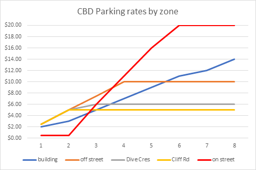
Attachment 1B: Financial modelling of option 3 –
nominal charge with considerably higher charging thereafter.
1. The
adopted annual plan prices are as follows:
(a) Paid
parking areas – per hour (on street and off street): $2.50
(b) Option
3 stays within the agreed hourly parking rates for the first two hours
($0.50/hour). Instead of a solid time limit, the recommended approach allows
for those wishing to stay longer. The recommended price for those additional
hours would be $5.00, and all-day on-street parking would be capped at $20.00.
This ‘cap’ provides an opportunity for people to park all-day,
should it meet their needs, but provides a financial incentive to park in an
off-street space or parking building for all-day parking.
(c) It
should be noted that parking spaces that currently have a time limit of 15 or
30 minutes would be required to remain free under option 3 given the low fee
per hour. If the prices were adjusted, this recommendation would need to be
revisited.
2. Based
on 1092 on-street chargeable spaces, an hourly fee of $0.50/hour for the first
two hours, and $5.00 for third and following hours, the calculated future
revenue based on high level assumptions on paid occupancy are that few visitors
would pay for a 3rd hour (as they would use a parking building or
off-street car parking instead). The potential annual revenue has been
forecasted to be approximately of $1.5m (excluding costs/revenues for enforcement).
In comparison, the current trial does not provide any revenue for the on-street
spaces and the previous charging methodology ($2.50 per hour) would have
generated approximately $2.0m of revenue in one financial year. These
figures are all including GST.
3. In
line with assumptions from previous years, the occupancy levels have been
assumed at 50%. The actual occupancy would be higher, but the actual paid time
differs significantly to the occupied time. Occupancy levels and related
revenue relating to parking buildings and other off-street car parks have not
been revised as the assumption is that the proposed pricing for on-street
spaces would effectively ‘act’ as a time limit as per the current
free 2-hour trial.
4. Attachment
1C provides a comparison of monthly user fee revenue for the past three
financial years. This shows the impact of not charging for on street parking on
the parking activity.
5. The
graph below shows a pricing comparison between on-street and off-street parking
areas.
Attachment 1C: Parking revenues in financial years
2018/2019, 2019/2020 and 2020/2021 (per month)

Attachment 1D: Number of parking transactions by price
breakdown
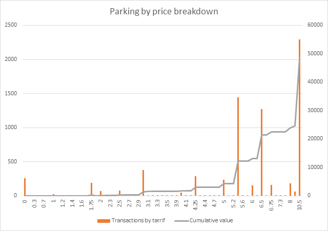
This graph shows that during October in the paid car
parks 50% of parking revenue was from all day parking and paid by credit card.
In October, we collected $55,560 (right Y-axis) in parking fees from of street
carparks. Of these parking fees, 56% was collected via the Pay my Park App
and the rest via meters, of this only $3,642 (6.5%) was collected in
cash. In transaction numbers it was 60% PMP, 30% meter by credit card and
10% meter by cash. Significantly more short-term parking is paid by cash
and this could be a result of the 50c transaction fee applied to credit card
payments. The fees that were added to the credit card transactions
totalled $1,165, almost half the value of all cash transactions.
Attachment 1E: Infringement data
Image 4.1:
Number of infringements issued from March 2019 – October 2020
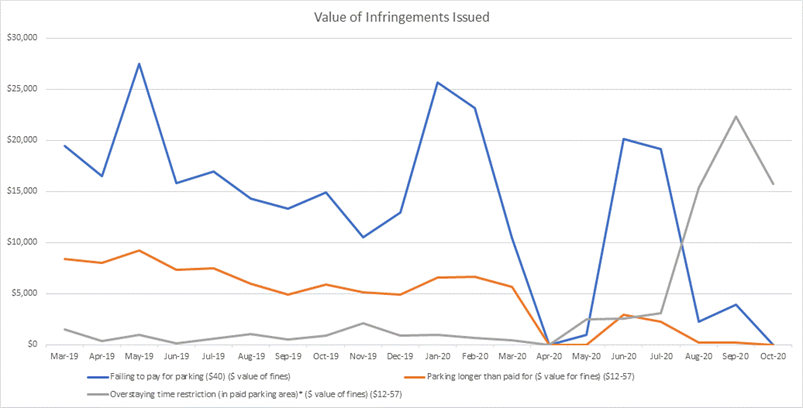
Image 4.2:Total value of infringements, for
‘Failing to pay, overstaying time limits, and parking longer than paid
for’ issued from March 2019 – October 2020
 Image
4.3: Total value of parking infringement tickets
Image
4.3: Total value of parking infringement tickets
9.2 Growth
& Land Use Projects Progress Reports - November 2020
File
Number: A11861129
Author: Andy
Mead, Manager: City & Infrastructure Planning
Authoriser: Christine
Jones, General Manager: Strategy & Growth
Purpose of the Report
1. Tauranga City is
continuing to experience rapid growth. Managing this growth is a
significant issue for Council. The report enables Elected Members to
monitor progress on key projects related to managing growth in a sustainable
manner.
|
Recommendations
That the Urban Form and Transport Development Committee
receives the Growth & Land Use Projects Progress Report – November
2020.
|
Executive Summary
2. Tauranga City is
continuing to experience rapid growth. Managing this growth is a significant
issue for Council, particularly the challenge of ensuring growth is sustainable
in a four well-beings context for both current and future communities.
3. The attached report
outlines the progress being made in relation to a number of projects necessary
to manage this continued growth. This information is also regularly
reported to the SmartGrowth partners & the SmartGrowth forums.
4. Key points to note in
this update include:
(a) Completion and adoption of the
Te Papa spatial plan.
(b) The progression of Housing Choice,
Flooding and Earthworks Plan Changes to public notification, with the
submission process closing on the 18 December 2020. Ten community open
days are being held across the city between 23 November and 4
November to provide further information on the proposed plan changes.
(c) Continued progression of the
City Plan Review. Attachment B included to this report identifies the key
issues for research and investigation through Phase 1 and 2 of the project.
(d) Progression of the boundary
re-organisations for Tauriko West, Keenan Road, Lower Belk Road and Tara Road,
which will provide for the future long-term planning of these areas as part of
the City Plan Review.
(e) Progression of the Resilience
Project, and completion of the prioritisation process for inclusion in the
LTP. A separate report and presentation on this project is part of the 24
November UFTD agenda.
Strategic / Statutory Context
5. While growth is a
significant issue for Tauranga City, this report does not require any decisions
and it is not significant in itself.
Options Analysis
6. There are no options;
this report is for information only.
Significance
7. While growth is a
significant issue for Tauranga City, this report does not require any decisions
and it is not significant in itself.
Next Steps
8. Council will continue to
progress the projects and works as identified in the report attachment.
Attachments
1. Appendix A -
Quarterly Update - Growth and Land Use - A11861056 ⇩
2. Appendix B - Quarterly
Update - City Plan Review Key Issues - UFTD Committee - 24 November 2020 -
A11939780 ⇩
|
Urban Form and
Transport Development Committee Meeting Agenda
|
24 November
2020
|
Quarterly Update – Growth /
Land Use Planning Projects – November 2020
|
PROJECT
|
PROGRESS
UPDATE
|
1.
NEXT STEPS
|
|
Spatial
Planning Programme
|
Te Papa Spatial
Plan
On 13 October
TCC’s UFTD Committee resolved to approve the Te Papa Spatial Plan,
agreeing in principle to the Te Papa peninsula 30-year Implementation Plan to
support the recommended urban form, movement and broader spatial plan
outcomes, subject to further investigation and funding availability. The
investment timing, costs and cost sharing are now subject to Long Term Plan
funding prioritisation and further investigations and agreement between the
project partners, which will come before Council for approvals as the Te Papa
programme progresses. Implementation of the outcomes of the Te Papa Spatial
Plan area is also proceeding with the commencement of Plan Change 26 and the
Cameron Road Multimodal Project.
Future Spatial
Planning
As part of the 24
November UFTD Committee reporting, Council have prepared a report seeking
approval to commence with the planning for the next spatial planning areas,
in alignment with direction of UFTI:
a) Mount
Maunganui North to Bayfair / Arataki; and
b) The
Otumoetai to Brookfield Peninsula area, including Matua, Pillans Point,
Bellevue, Judea and Cherrywood
Initial details of
the proposed scope and timing are outlined in the 24 November UFTD report,
with further detail proposed to be brought before Council in early 2021.
|
Te Papa Spatial
Plan
Ongoing
– Te Papa Long Term Plan funding prioritisation through LTP process.
Ongoing –
discussions and planning with key project partners, government agencies and
stakeholders in relation to housing regeneration within the peninsula,
particularly around Gate Pā/Pukehinahina and Merivale.
Future Spatial
Planning
24
November UFTD Committee reporting, seeking approval to commence with planning
for the next spatial plan areas.
Early
2021 – further detailed reporting in relation to scope, timing and
engagement.
|
|
Smart-Growth
Joint Spatial Plan (JSP)
|
The Government
confirmed in early 2020 that it wishes to partner with SmartGrowth (councils
and tāngata whenua) in order to progress and deliver on its Urban Growth
Agenda. A key component of this is the development of a Joint Spatial Plan
(JSP) covering the western Bay of Plenty which will build on UFTI, become a
replacement SmartGrowth Strategy 2021 and deliver on the Urban Growth Agenda.
The JSP will have a
narrower focus than the 2013 SmartGrowth Strategy, especially in terms of the
implementation plan which will focus on a concise list of short, medium and
longer-term transformational initiatives relating to land use, housing,
transport integration and wider infrastructure provision at the sub-regional
scale. Key aspects of the project include:
a) Converting
the UFTI Final Report, Proposed FDS 2018 and the existing supporting material
into a framework, similar to the Hamilton-Waikato Metro Spatial Plan, and
address any immediate short-term gaps.
b) That
it will primarily be developed as a desktop exercise, relying on targeted
engagement (not a formal SCP process under the LGA), with a target completion
date and approval prior to 1 July 2021.
c) Identify
gaps for filling in next iteration of the JSP, noting a fuller more
comprehensive JSP will be developed between 2021-2024 to meet the
requirements of the NPS-UD.
d) The
JSP will include a work programme of actions. One of these will be the Iwi
Spatial Plan which is being scoped up separately and being led by the
SmartGrowth Combined Tangata Whenua Forum.
TCC’s current
role includes sitting on the JSP Working Group to oversee the Joint Spatial
Plan delivery, providing workstream lead roles in relation to the Green-Blue
(water and green networks) and 3-waters layers, and inputs into wider spatial
plan layers.
|
Nov
2020 – scoping of terms of reference and inputs
Nov
2020 – Feb 2021 – preparation of draft JSP inputs from partners,
including specific workstream leadership from TCC staff, and review by TCC
working group members.
March
2021 – draft JSP for review
Mid
2021 – Final JSP (Version 1)
2021-2024
– further development of JSP to meet requirements of NPS-UD and respond
to any gaps in identified in version 1.
|
|
Plan
Change 26 - Housing Choice
|
Resolution was
received to adopt Plan Change 26 (Housing Choice) for public notification at
the UFTD committee and Full Council meetings held on 13 October 2020.
Public notification
is currently underway, and the submission period closes on the 18 December
2020. Staff are available to answer questions and have one on one
conversation during this time. In addition, 10 community open days are being
held across the city between 23 November and 4 November to provide
further information on the proposed plan changes.
Plan Change 26 has
been progressed to enable greater housing choice and residential density in
existing urban areas.
|
Public notification
16 November to 18 November. Summary of submissions and further
submissions in early 2021.
A report will be
presented in early/mid 2021 providing a summary of the key issues received
through submissions and seeking direction on the hearings panel.
|
|
Plan
Change 27 - Flooding from intense rainfall Plan Change
|
Resolution was
received to adopt Plan Change 27 (Flooding from intense rainfall) for public
notification at the UFTD committee and Full Council meetings held on 13
October 2020.
Public notification
is currently underway, and the submission period closes on the 18 December
2020. Staff are available to answer questions and have one on one
conversation during this time. In addition, 10
community open days are being held across the city between 23 November
and 4 November to provide further information on the proposed plan
changes.
Plan Change 27 has
been progressed to propose a rule framework to reduce the risk of flooding
from intense rainfall in Tauranga.
The proposed Plan
Change 27 provisions are not beyond appeal, but they do have legal effect.
Delegation has been
used by the General Manager: Strategy & Growth to approve the
introduction of Rule 8D.7 exempting any building consents lodged prior to
notification (16 November 2020) from requiring a Resource Consent under Plan
Change 27.
|
Public notification
16 November to 18 November. Summary of submissions and further
submissions in early 2021.
A report will be
presented in early/mid 2021 providing a summary of the key issues received
through submissions and seeking direction on the hearings panel.
|
|
Plan
Change 30 - Earthworks
|
Resolution was
received to adopt Plan Change 30 (Earthworks) for public notification at the
UFTD committee and Full Council meetings held on 13 October 2020.
Public notification
is currently underway, and the submission period closes on the 18 December
2020. Staff are available to answer questions and have one on one
conversation during this time. In addition, 10 community open days are being
held across the city between 23 November and 4 November to provide
further information on the proposed plan changes
Plan Change 30 has
been progressed as a technical plan change to clarify existing rules to
remove ambiguities. It does not adjust the wider earthworks policy
approach and plan provisions, which will be addressed in the upcoming City
Plan Review.
|
Public notification
16 November to 18 November. Summary of submissions and further
submissions in early 2021.
A report will be
presented in early/mid 2021 providing a summary of the key issues received
through submissions and seeking direction on the hearings panel.
|
|
City
Plan Review
|
The review of the
City Plan is a statutory requirement every 10 years under the Resource
Management Act 1991. The current operative Tauranga City Plan became
operative in September 2013. Government direction through the national planning
standards also requires the next Tauranga City Plan to be prepared and
notified for public submissions by April 2024.
A workshop with
Councillors has been undertaken to identify key issues to be considered
through the City Plan Review. Twelve internal workshops have also been
undertaken with staff to identify issues to be considered through the City
Plan Review. Staff are now working through these issues to identify research
and investigation workstreams.
A
separate attachment has been included to this report identifying the key
issues for research and investigation through Phase 1 and 2.
|
Continue with Phase
1 (research and investigation) and Phase 2 (issues and options).
Identification of issues and options with key stakeholders will commence in early
2021.
|
|
Tauriko
West Urban Growth Area
|
Tauriko West Urban
Growth Area is a collaborative project with Tangata Whenua, landowners and
three key partners being Western Bay of Plenty District Council
(WBOPDC), Bay of Plenty Regional Council (BOPRC), and New Zealand Transport
Agency (NZTA).
Tauriko West is
located partially within WBOPDC and TCC jurisdictional areas. A
reorganisation proposal has been confirmed by the Local Government Commission
(LGC) and is expected to become effective in January 2021. A group has
been established to meet transition requirements between the councils; and
the first Order in Council has been approved by the Governor General to
enable progression of the transition requirements.
Work is also
underway by TCC staff to develop further understanding of the infrastructure
requirements to service Tauriko West and the necessary sequencing.
Presented as a Staging Plan this identifies respective areas across Tauriko
West and the necessary requirements to deliver the servicing to enable
development to proceed in a coordinated and efficient manner, while also
ensuring that as Tauriko West progresses, it is integrated with development
across the wider western corridor and the City. Recent investigations
have focused on wastewater capacity and availability of connections in the
south through Redwood Lane and to the upper plateau through Whiore Avenue.
Discussions with landowners on staging options, priority of connection and
constraints to development continue while such investigations are
finalised.
The discussions
with landowners include developing appropriate cross sections for the main
internal road corridor in order to develop an agreed set of principles that
will address issues associated with corridor width, extent of bus priority,
cycle/pedestrian facilities and provision for utility corridors. Recently
developed guidance will be shared with landowners as this detail is further
developed; and liaison with network utility operators continues to identify
adequate provision for services within the road corridor.
Significant
progress has been made with landowners to agree the principles associated
with stormwater management and the implications for landform
refinements. An agreed Concept Landform has been developed in liaison
with landowners, and further work is now underway to address natural inland
wetlands and diversion of modified watercourses in accordance with the recently
released NPSFM as well as the new National Environmental Standard for
Freshwater (NESFW).
The Tauranga City
Council continues to progress work on the development of the future structure
plan to incorporate all necessary infrastructure. This includes the
initial State Highway roading improvements to enable Tauriko West to
progress, strategic wastewater and water supply assessments for both the
interim and long-term periods, and progression of work for a future
comprehensive stormwater consent. Work has commenced on the preparation
of the RMA planning provisions and appropriate zoning of land for the Tauriko
West plan change. Market Economics and 4Sight Planning have recently been
engaged to deliver an assessment of policy options to drive increased housing
densities and a wider variety of housing in the Urban Growth Area.
Work continues with
NZTA on State Highway Planning, for early access to the proposed growth area
and long-term upgrades for SH29. Further investigations by NZTA
continue for SH29/SH29A upgrade options.
|
The Concept
Landform developed in agreement with landowners is now subject to further
assessment of natural inland wetlands and stream diversions/relocations
proposed, under the (new) National Policy Statement for Freshwater Management
(NPSFM) provisions. Further work on stormwater management and structure
plan related details awaits outcome.
The further
ecological assessment of wetlands will be undertaken in liaison with the
landowners and BOPRC; and is likely to identify additional wetland areas
which subsequently reduces the extent of developable land and the associated
yield.
Ongoing liaison
with Te Kauae a Roopu (Hapu based forum) as part of the Iwi/Hapu engagement;
and work to continue on the Maori (Cultural) Values Assessment coordinated by
Te Kauae a Roopu. Separate liaison with Iwi required.
Continue working
with NZTA on State Highway Planning, for early access to the proposed growth
area and long-term upgrades for SH29.
Continue technical
workstreams, particularly for flood risk assessment, groundwater and
ecological assessments, and Plan Change drafting.
Progress with the
required steps to meet the first Order in Council in regard to the Transition
Body, which is to establish an implementation team to develop a plan which is
then progressed to the second Order in Council to allow the progression of
tasks to meet the reorganisation plan.
Continue engagement
with Government agencies in relation to the proposed RMA national directions.
This includes consideration of the new National Policy Statements for Urban
Development and Freshwater Management, the new National Environmental
Standard for Freshwater and potential streamline zoning pathways.
|
|
Te
Tumu Urban Growth Area
|
Council have
completed the majority of technical assessments to inform the structure plan.
The inputs for the technical reports have been based on three population
scenarios to ensure that appropriate infrastructure can be delivered. These
three population scenarios range from a base of 15,500 people up to 25,000
people.
Most technical workstreams are now complete
with final reporting in the process of being reviewed including a stormwater
management strategy. A review is to commence shortly on the impact of
recently enacted National Policy Statement for Freshwater Management 2020
(Freshwater NPS 2020) and its impacts on stormwater management within Te
Tumu. Updates to some natural hazard work has also taken place to
account for updated Ministry for the Environment guidance on sea level rise
– including updates to tsunami and coastal erosion modelling.
Transport modelling is continuing to help inform final road corridor and
intersection concept development. These road corridors include the
provisions for walking, cycling and public transport. Reporting has
also been finalised in respect to natural hazard risk for lifeline
infrastructure. The outputs of this are being considered in respect to
adherence with the Regional Policy Statement. All these workstreams will
inform the structure plan and plan change documentation.
Work is ongoing in respect to the
preparation of the RMA planning provisions and the identification of
appropriate zoning and rule frameworks for the Te Tumu Plan Change.
Consideration is now also being given to the requirement for enablement
provisions around building heights and density in accordance with the
National Policy Statement on Urban Development 2020 (NPS-UD 2020).
These requirements are being considered alongside existing technical work
that has already been completed. Development of a framework for
reporting on Plan Change content in accordance with RMA Section 32 has also
commenced. Discussions with landowners are ongoing in relation to the
preparation of funding agreements for the delivery of infrastructure and
services within this urban growth area, along with the potential staging of
these assets. Also, as for Tauriko West above, Market Economics and
4Sight Planning are in the process of finalising an assessment of policy options
to improve housing density and diversity outcomes in Te Tumu.
On 9 April 2020 the
Māori Appellate Court released its decision affirming the 24 October
2018 decision of the Māori Land Court to dismiss the application by the
Tumu Kaituna 14 Trust for a change of status of a 55 hectare portion of the
land block (from Māori land to general land) and a Trust order
variation. The Trust has subsequently lodged an appeal of this decision
with the NZ Court of Appeal. This appeal is scheduled to be heard by
the Court in Feb 2021. Therefore, provision of infrastructure corridors
through this land to support delivery of development within the remainder of
the growth area will be subject to the outcomes of the Court of Appeal
process and landowner engagement via the various affected Māori
landowners. It is expected that urban development within this growth area
will now be further delayed, until such a time as access through this
Māori land block to the remainder of the growth area can be confirmed.
|
Complete infrastructure
planning and road corridor planning assessments.
Undertake wetland
re-assessment in line with requirements of Freshwater NPS 2020.
Continue finalising
reporting from technical workstreams and preparation of plan change documentation.
Complete structure
planning processes.
Develop
updated communications and engagement program for Te Tumu, in
preparation for re-engagement with iwi authorities, and wider community in
progression for future plan change progression.
Continue to work
with TK14 Trust on TCC proposal for next steps on infrastructure corridor
creation.
|
|
Future
Urban Growth Areas:
Keenan
Road
|
The Local
Government Commission (LGC) have met to decide whether 390 ha of land in the
Keenan Road area should be included in a boundary reorganisation to
facilitate development of this area.
A project plan is
being developed for the area to enable structure planning to progress in time
for the City Plan Review assuming that the LGC transfers this land to the
City in the near future.
Long-term
wastewater study for the Western Corridor is complete and was reported
previously to an earlier UFTD meeting. This study provides for
wastewater servicing in the Keenan Road area. A similar potable water
study is nearing completion.
|
Continue to work
with the LGC and WBoPDC on the proposed boundary reorganisation to move the
Keenan Road area into Tauranga City.
Progress a project
plan for the future structure planning and rezoning of the area.
Complete water
planning study.
|
|
Future
Urban Growth Areas:
Lower
Belk Road area
(Tauriko
Business Estate Extension)
|
The LGC has met to
decide whether 175ha of land in the Lower Belk Road area should be included
in Tauranga City. This area is earmarked for an extension of the
Tauriko Business Estate in current planning documents such as the urban
limits, SmartGrowth and UFTI.
Long-term water
study and wastewater servicing studies have been undertaken for the Western
Corridor as the result of structure planning of Tauriko West. These
studies include consideration of the Tauriko Business Estate extension
area.
|
Continue to work
with the LGC and WBoPDC on the proposed boundary reorganisation to move the Lower
Belk Road area into Tauranga City.
Complete water
planning study.
Complete
investigations into transport improvements for approval by TCC and NZTA.
|
|
Future Urban Growth
Areas:
Ohauiti South
|
In August 2020
Tauranga City Council staff completed the Welcome Bay and Ohauiti Planning
Study. The purpose was to better understand the infrastructure needs,
options and costs to accommodate additional housing growth within the Welcome
Bay and Ohauiti area. The assessment work and resulting report
identified and assessed a number of locations within the Study Area that were
potentially suitable for additional housing development while also assessing
the capacity of services and infrastructure to accommodate additional
demand.
Specific
infrastructure assessments were undertaken for three waters, transport,
social and commercial infrastructure. The Study ultimately found that
accommodating housing at suitable densities was most feasible in the Upper
Ohauiti Road Area. The area on Ohauiti Road is at the southern extent
of Tauranga City Council’s jurisdiction is presently zoned as Rural
with a portion of Greenbelt overlay. It amounts to approximately 54 ha and is
presently in single ownership.
Council has
approached the landowners to seek direction on whether they are willing to
lead their own rezoning and structure plan process. The landowner has
decided that they do not have the financial resources/imperative to undertake
structure planning for the property, but would not oppose the Council
undertaking re-zoning and structure planning of R346 Ohauiti Road for
residential development.
|
Determine whether
Council will undertake the structure planning and rezoning of the area at its
cost as part of the City Plan Review.
This is not
currently a priority within the team’s work programme and the matter
will be reconsidered once the Te Tumu and Tauriko West projects have been
progressed to public notification.
|
|
Tara Road
|
The LGC has met to
decide whether an area of land along Tara Road (bounded by Tara Road, Parton
Road and the Tauranga Eastern Link should be included in Tauranga City.
This is not a planned urban growth area however it is largely Crown owned.
|
Continue to work
with the LGC and WBoPDC on the proposed boundary reorganisation to move the
Lower Belk Road area into Tauranga City.
Engage with
government officials in respect of any potential future plans for this area.
|
|
Rural
Land Study
|
This project has
not progressed since the last quarterly update as it is not a priority
workstream relative to other work underway across the team. The
previous update is repeated below.
A desktop study is
nearly complete to determine the urbanisation potential of the remaining
rural land areas within the city boundaries namely Bethlehem South, Oropi
Road, Papamoa Hills, Papamoa and Matapihi.
Draft findings are
complete. There is no significant urbanisation potential identified in
Bethlehem or Oropi, however, there are small areas in Oropi, which could be
considered for Rural Residential. For Papamoa and part of Papamoa Hills
catchments show that urbanisation potential is challenging as the land blocks
are located on peat soils and with other constraints such as flooding.
Further investigation is required to understand the extent of ground
conditions challenges and mitigation measures before considering future
urbanisation of these areas. However, it should be noted that a number
of parties have development aspirations in these areas and some are
progressing their own investigations and considering resource consent
processes.
The draft findings
identify that there is potential for urbanisation in Matapihi and some parts
of the Papamoa Hills area, however both catchments have large areas of
multiply-owned Maori Land and urbanisation may not be consistent with the
aspirations of these communities. Future engagement will be required with the
landowners to understand aspirations and opportunities in this area.
|
The Rural Land
Study is being finalised. The intention is that the findings of the study
will be reported to UFTD in 2021.
It is likely that
the aspirations for Maori land identified in the study will be considered
through the proposed ‘Iwi Spatial Plan’ which is an action from
UFTI to be progressed over the next 12 months.
The Study will also
be a key input into the City Plan Review.
|
|
Smith’s
Farm
|
Staff are
continuing to explore options to progress the development and sale of Smiths
Farm for residential housing. This will be reported back to
the Committee most probably early in 2021. The main constraint is the
cost, timeframes and risks associated with access.
With the NZTA
Tauranga Northern Link project progressing at pace, NZTA advise that it needs
to complete a cost sharing MOU with TCC in respect of access and the proposed
shared stormwater solution before the end of the 2021 calendar year.
In broad terms NZTA
will met the costs of retaining a like for like access as currently provided
by Richards Way. TCC would meet the additional costs of an upgraded
access to enable urban development. Good progress has been made on
refining the MOU over the last few months. At present the cost of the
access road is at a level that aligns with the development aspirations for
Smiths Farm however greater cost certainty will not be known until the tender
price is available (likely in December 2020). A final decision on
whether TCC will commit to the access road is required in the first quarter
of 2021 and as report will be brought to the Committee in relation to this
decision.
The timing of the
access road being completed may come toward to end of the TNL construction
period. Payment for TCC’s cost share would be upon completion of
the road which could align with revenue from the potential sale or
development of the site.
TCC is able to
apply for FAR subsidy for its share of transport costs through separate NZTA
processes. There appears to be a reasonable prospect of securing
funding. A point of entry has been agreed with NZTA and this will be
considered at its November or December delegations committee. It is
hoped that NZTA will approve the project to move to the pre-implementation
phase at this time and endorse funding for the project.
|
Compete
investigations and prepare Committee report.
Complete cost
sharing MOU with NZTA for Chief Executive signing.
Report to elected
members in early 2021 to determine commitment to access road construction and
funding.
|
|
Government
Policy & Initiatives
|
A substantive
update of proposed RMA reforms was made through the last quarterly
update. No further progress has been reported by the Government on its
review of the RMA of the last quarter due to the election period. We
expect this to be a significant focus for the Government in 2021.
Freshwater and
Urban Development national directions are now in place as reported in further
detail at the last two UFTD meetings.
The Government is
still progressing:
- NPS on Highly
Productive Land: Consultation closed on 10 October 2019. The Ministry for the
Environment (MfE) and the Ministry for Primary Industries (MPI) are reviewing
the proposed National Policy Statement for Highly Productive Land (NPS-HPL)
based on public submissions. The work to further develop the policy was
affected by the government's need to focus on the response to COVID-19 and
ongoing recovery. Officials now expect to provide final advice to Cabinet in
the first half of 2021. If approved by Cabinet, the NPS-HPL will likely take
effect soon after.
- NPS on
biodiversity: The Government has outlined that the Biodiversity NPS is now
set for release in April 2021.
|
Continue to make
submissions as appropriate and engage with the Government and its officials
on matters as they relate to Tauranga.
|
|
Natural
Hazards & Resilience Planning
|
Separate reporting
on the Resilience Project is occurring on the November UFTD meeting.
Developing
resilience in design and strategic thinking among the technical professionals
and consultants of the city is a key means of achieving the objective of
building a resilient Tauranga. Resilience presentations have been made to
several consultants (WSP, Maven, Boffa Miskell), two professional
institutions (ACENZ and ENZ) and two conferences in the last quarter. Two
national conferences with a resilience focus have been hosted by Tauranga-
the National Lifelines Utilities Forum and the GNS Volcano Short Course.
Modelling of open
coast inundation from Mount to Te Tumu is currently being undertaken by NIWA
for BoPRC and the results will be incorporated into TCC hazard maps. Release
of this information to the community is anticipated in second quarter 2021.
It is likely to impact a number of properties along the coast and an
appropriate engagement program is being developed around this.
City wide land
stability assessment has started and will continue through Q1 2021. This will
be a technical advance on our current static hazard lines and will
incorporate probability into the analysis for the first time. TCC has
initiated a Super regional steering group with BoPRC, Waikato Regional
Council, Auckland Unitary Council and EQC in order to standardise our
approach and share resources. A pilot study completed in December 2019
indicated that this new probabilistic mapping is not likely to negatively
impact properties as the existing 2001 mapping is generally conservative by
comparison.
Regional Lifelines
Climate Change Risk Assessment is in progress. Tonkin and Taylor were engaged
by Emergency Management BoP in October with scope and deliverables determined
by TCC and other stakeholders. Output will be in Q1 2021 and will input into
city resilience evaluations as well as providing evaluations of risks to main
lifelines for the city such as power and transport.
BoPRC is
progressing considerations to make changes to the Regional Policy Statement,
in regard to Natural Hazards planning. This work flows from current
implementation issues raised by territorial authorities and professional
consultancies. The current phase of work includes understanding the
issues with RPS natural hazards implementation and potential short term
implementation solutions. BoPRC are of the view that the RPS Natural
Hazards policies and methodology changes will not be a full scale review,
rather will focus on specific implementation issues to aid in interpretation
and implementation of the existing approach.
|
Completion of
studies on land stability, and open coast inundation.
|
|
Urban Form and Transport Development
Committee Meeting Agenda
|
24 November
2020
|
Key
Issues for Tauranga City Plan Review, October 2020
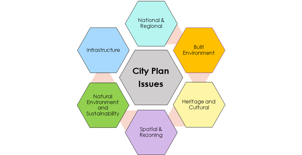
Note: There are a range of issues that the City
Plan Review project will need to consider. Those contained in this list are
considered the key issues for the development of the next Tauranga City Plan
Review. However, it is not a definitive list and issues can be added, amended
or deleted as the project progresses. How key issues are addressed will be
determined following the development of options for each key issue.
Opportunities will be provided for stakeholders, tangata whenua and the
community to provide input.
|
Reference
|
Issue
|
Summary
|
Scale
|
Priority
|
Processes/actions required
|
|
National
& Regional
|
|
N1
|
Resource Management Act reform
|
Understand
future implications if RMA is replaced and what transitional provisions will
apply. Likely three years away at least.
Some form of district plan
will still be required for Tauranga, even if combined.
|
Large
|
Low
|
Council
to retain a watching brief on this process as it may impact on future
processes.
Opportunities
for Council to be involved on any new legislation eg. through submissions.
Risk to City
Plan Review to be monitored.
|
|
N2
|
National Policy Statement – Urban Development (NPS-UD)
in effect from 20 August 2020
|
NPS-UD
sets out how and where housing and business land for growth must be
accommodated.
Requirement for
intensification plan change within 18 months of gazettal from 20 August 2020
and no car parking minimums. Implications for whether City Plan requires
turning circles and access in relation to road hierarchy.
|
Medium
|
High
|
Refer
report to 1 September UFTD Committee. Minimum carparking requirements in
current City Plan to be removed by public notice in November.
Consider
how best to manage any consequential effects on access, services and road
hierarchy.
|
|
N3
|
New National Policy Statements
- Freshwater
Management
in effect from 3 Sept 2020
- Highly
Versatile Land
(due April 2021)
- Indigenous
Biodiversity
(due April 2021)
|
Freshwater
NPS largely at regional council level but some requirements on territorial
authorities to include objectives, policies and methods for water quality.
Highly Versatile Land and
Indigenous Biodiversity NPS will have direct implications for City Plan.
|
Medium
|
Moderate
|
Assess
implications for City Plan.
Awaiting
central government guidance.
Some
directions to district plans through regional policy statement changes first.
|
|
N4
|
Natural hazard requirements of Bay of Plenty Regional Policy
Statement (RPS)
|
Development
of some existing urban areas may not be possible due to natural hazard risk
requirements, such as sea level rise. Review being undertaken to better
understand implementation requirements and determine whether a development
pathway exists.
Certainty
needed for being able to develop Mount-Papamoa and other existing urban areas
of Tauranga through intensification and spatial planning under the City Plan.
|
Medium
|
High
|
Natural
Hazards working group underway comprising staff from BOPRC, WBOPDC and TCC
operating under an agreed terms of reference.
Intention
to agree high level policy implementation and confirm gaps in susceptibility
modelling and risk assessment work.
Any
formal change to the RPS (if required) could include amending or removing
specific policies and showing how other risk management approaches can comply
with the RPS.
|
|
N5
|
Urban limits amendments
|
Urban
development is required to be within defined urban limits agreed through
SmartGrowth in the Regional Policy Statement. A formal change to the RPS is
required to include areas currently outside of the western Bay of Plenty
urban limits.
|
Medium
|
High
|
RPS
change to give effect to NPS-UD (which includes more enabling provisions for
greenfield development) UFTI and updated SmartGrowth spatial plan. Requires
completion of SmartGrowth spatial plan.
|
|
N6
|
Urban Form and Transport Initiative, SmartGrowth and transport
planning
|
Expectations on City Plan from UFTI and SmartGrowth spatial
plan.
Land use pattern that supports public transport and mode share.
Links with N2 above.
|
Large
|
High
|
Requires
development and completion of revised SmartGrowth spatial plan.
Te
Papa spatial plan and Plan Change 26 promote a more intensive land use
pattern to drive greater public transport, walking and cycling.
|
|
Reference
|
Issue
|
Summary
|
Scale
|
Priority
|
Processes/actions required
|
|
Built
Environment
|
|
B1
|
Housing affordability
|
Determine
what role the City Plan can have in assisting to make housing more
affordable. Significant previous work on this issue.
Consider
mechanisms such as Inclusionary Zoning.
|
Large
|
High
|
Actions
identified in the UFTI report and Homelessness Strategy. Investigate other
council’s district plans approaches (eg. Auckland City and Queenstown
Lakes).
Homelessness
Strategy Action Plan alignment with the actions in the UFTI report.
|
|
B2
|
Housing choice
|
Requirements
for enabling housing choice from single detached dwellings to apartment
living. Follows from Plan Change 26 – Housing choice and Te Papa
spatial plan.
Links
with N2 and B1 issues above.
|
Medium
|
Moderate
|
Investigate
what other councils’ City/District Plans require.
Consider
potential limitations of the RMA around implementation of mandatory
affordable housing provision.
|
|
B3
|
Visitor accommodation
|
Review
how plan addresses tiny homes, Air BnB, Book a Bach, portacabins, and
secondary independent dwellings.
|
Small
|
Moderate
|
Investigate
other councils use of regulatory tools, including the district plan to manage
these activities, and the cost requirements. Christchurch City is to notify a
plan change to address effects from un-hosted visitor accommodation.
Consider
rating and development contribution approaches.
|
|
B4
|
Commercial centres hierarchy
|
Develop
a commercial centres hierarchy for Tauranga to implement the zones set out in
the National Planning Standards.
|
Medium
|
Moderate
|
Spatial
mapping of national planning standard zones for Tauranga and what that means
in practice against outcomes sought.
Technical
input required from external experts.
|
|
B5
|
Industrial areas hierarchy
|
Develop
an industrial zones hierarchy to ensure implementation of the National
Planning Standards.
|
Medium
|
Moderate
|
Spatial
mapping of national planning standard zones for Tauranga and what that means
in practice against outcomes sought.
Technical
input required from external experts.
|
|
B6
|
Urban design
|
Investigate
urban design approaches that are pragmatic and outcome focussed, while
providing flexibility for development.
|
Medium
|
Moderate
|
Investigate
having an Urban Design Panel to assess development as a requirement of the
City Plan.
|
|
B7
|
Universal design
|
How
development allows for ageing in place and changing circumstances of those
living in housing.
Universal design is
the design of buildings, products or environments to make them
accessible to all people, regardless of age, disability or other factors.
|
Medium
|
Moderate
|
Investigate
other councils use of City/District Plan, and cost requirements. Undertake
high level assessment of potentially feasibly options for incorporating
universal design in new developments.
|
|
B8
|
Sequencing of development
|
Ensuring
orderly progression of services and infrastructure as well connectivity of
roads, cycleways and walkways
|
Medium
|
Moderate
|
Consider
greater regulatory intervention in development through structure planning,
staged development triggers and development contributions policy to require
sequenced development to occur.
Consider
options to require connectivity through objectives, policies and rules as
part of comprehensive development approach.
|
|
B9
|
Covenant restrictions to re-development
|
Determine
what role Council can have that limits covenants that restrict further
development opportunities.
|
Medium
|
Moderate
|
Revisit
existing work undertaken to address restrictive covenants to ensure
re-development opportunities.
|
|
B10
|
Social diversity
|
The role the City Plan might be able to play
in assisting in developing social diverse communities.
|
Medium
|
Moderate
|
Investigate
other councils use of City/District Plan. Undertake high level assessment of
potentially feasibly options for how social diversity might be encouraged in
new subdivision and development.
|
|
Reference
|
Issue
|
Summary
|
Scale
|
Priority
|
Processes/actions required
|
|
Natural
Environment and Sustainability
|
|
ES1
|
Sustainability - solar energy use
|
Consider
how City Plan could promote solar energy use for new development
|
Small
|
Low
|
Investigate
other councils use of City/District Plan, and cost requirements. Undertake
high level assessment of potentially feasibly options for sustainable energy
uses in new development.
|
|
ES2
|
Sustainability - water efficiency
|
Consider
how City Plan could promote water efficiency for new development
|
Small
|
Low
|
Investigate
other councils use of City/District Plan, and cost requirements. Undertake
high level assessment of potentially feasibly options for water efficient
uses in new development
|
|
ES3
|
Water quality
|
Consider
how the City Plan can maintain and enhance water quality in streams, rivers
and waterways around Tauranga.
Links
with N3.
|
Small
|
Low
|
Directed
by the new National Policy Statement for Freshwater Management.
Assess
options for further requirements in the City Plan.
|
|
ES4
|
Hazardous substances
|
Analysis
of the National Environmental Standards and other councils’ approaches
in their district plan to the management of hazardous substances and whether
additional controls are required.
|
Small
|
Low
|
Investigate
other councils use of City/District Plan, and cost requirements.
Undertake
high level assessment of potentially feasibly options with pros and cons for
controlling hazardous substances in the City Plan.
|
|
ES5
|
Tree protection
|
Register
and Significant Notable Trees to be reviewed and approach to tree protection
in plan. Links with ‘Growing Tauranga Green Strategy’ 2006 and
Council’s ‘Vegetation and Tree Management Policy’.
Complex
due to high community interest.
|
Medium
|
Moderate
|
Current
approach to identifying and protecting significant trees to be reviewed. High
level options to be presented.
Review
of tree register with landowners able to nominate any additional trees for
assessment.
|
|
ES6
|
Ecological preservation and protection
|
Significant
Ecological Areas re-assessment in plan and any amendments needed, including
mapping.
Section
6(c) RMA requires the protection
of areas of significant indigenous vegetation and significant habitats of
indigenous fauna.
|
Small
|
Low
|
Technical
work to be undertaken by ecological experts.
Assessment
to be undertaken after National Policy Statement for Indigenous Biodiversity
released (April 2021) to confirm criteria for assessment.
|
|
ES7
|
Outstanding landscapes and important amenity landscapes
|
Re-assessment
of significant landscape areas in plan and any amendments needed, including
mapping.
Section
6(b) RMA requires the protection of outstanding natural features and
landscapes from inappropriate subdivision, use and development.
|
Small
|
Low
|
Technical
work to be undertaken by landscape experts.
Council
required to identify and protect significant landscapes and natural features.
|
|
ES8
|
Low impact design
|
Consider
how low impact design measures can be incorporated into new development.
Low Impact Design (LID) is an
inter-disciplinary design approach to stormwater management which
seeks to deliver integrated solutions and achieve multiple benefits from land
development.
|
Medium
|
Moderate
|
Review
low impact design guidelines associated with Infrastructure Development Code.
Investigate
other councils use of City/District Plan to require and/or encourage low
impact design. Undertake high level assessment of potentially feasibly
options with pros and cons for requiring low impact design measures through
the City Plan.
|
|
Reference
|
Issue
|
Summary
|
Scale
|
Priority
|
Processes/actions required
|
|
Heritage
and Cultural
|
|
C1
|
Cultural heritage
|
Undertake
an assessment of archaeological sites and cultural heritage, to determine
what additional areas may need to be included in the plan.
|
Medium
|
Moderate
|
Technical
re-assessment by external experts, in close consultation and discussion with
tangata whenua, iwi/hapu authorities and Heritage NZ.
Assess
mechanisms to protect sites in City Plan and whether current approach is
sufficient.
|
|
C2
|
Viewshafts
|
Review marae viewshafts in
light of spatial planning outcomes and potential conflicts with NPS-UD
intensification requirements.
|
Small
|
Moderate
|
Technical
re-assessment by external experts
|
|
C3
|
Whareroa marae
|
Consider planning pathways
for the protection of Whareroa Marae community from the adverse effects of
industrial activities.
|
Medium
|
High
|
Council
decision to investigate with initial scoping study with BOPRC.
Direction
from legal advice.
|
|
C4
|
Maori Land (Trusts Land)
|
Determine
how to progress land-uses on multiple owned Maori land inclusion in City
Plan.
|
Large
|
Moderate
|
Engagement
with land trusts, including Te Aro Whenua (group of larger trusts and
entities in Tauranga). Assess options to achieve outcome sought eg. rezoning.
|
|
C5
|
Review and updating of iwi and hapu management plans, including
Ngati Hangarau
|
Consider
how City Plan can assist iwi and hapu achieve outcomes sought in their rohe.
|
Small
|
Moderate
|
Council
required to take into account iwi and hapu management plans.
Awaiting
completion of Ngati Hangarau hapu management plan to provide aspirations.
|
|
C6
|
Significant Maori Areas (SMA)
|
Review
of SMA sites and addition of new sites to be considered following landowner
engagement. Review of provisions to protect/manage SMAs.
|
Small
|
Moderate
|
Technical
work to be undertaken by external expert to then inform discussions with
tangata whenua, iwi/hapu authorities, landowners and others.
Undertake
high level assessment of options to comply with section 6(e) RMA to provide
for the relationship of Maori and
their culture and traditions with their ancestral lands, water, sites, waahi
tapu, and other taonga.
|
|
C7
|
Papakainga housing
|
Identify
how the City Plan can provide and assist with the delivery of papakainga
housing.
|
|
|
Actions
identified in the UFTI Final Report. Potential opportunities will stem from
engagement conversations with iwi, hapu, marae, housing and Maori land trust
entities.
|
|
C8
|
Iwi spatial planning
|
Identify
and consider how the City Plan might enable development of Maori land and
Crown settlement land. Identifying protection of cultural values that would
incorporate several of the Cultural and Heritage issues above.
|
|
|
UFTI
action for iwi spatial planning. Spatial planning outcomes to be considered
through City Plan Review.
|
|
Reference
|
Issue
|
Summary
|
Scale
|
Priority
|
Processes/actions required
|
|
|
Spatial
& Rezoning
|
|
S1
|
Accommodating future growth
|
Confirming
land use pattern for future growth in meeting the requirements of the
National Policy Statement on Urban Development.
Links
with N2 and N6 above.
|
Large
|
High
|
Requires
development and completion of revised SmartGrowth spatial plan.
|
|
|
S2
|
Application of National Planning Standard zonings
|
Spatially
map the zones required to be used in the City Plan by the National Planning
Standards.
|
Medium
|
High
|
Ensure
outcomes fit with City Vision for Tauranga – are activities occurring
in the right place?
|
|
|
S3
|
Industrial activity vs business activity
|
Provide
better certainty of outcomes to ensure activities occur in appropriate parts
of Tauranga.
|
Small
|
Low
|
To
be clarified through the commercial centres and industrial hierarchy work.
|
|
|
S4
|
City centre vibrancy / liveability
|
What
is needed to encourage residential development to enable more people to live
in and near the City centre?
|
Medium
|
High
|
Analysis
to understand drivers / impediments to City Centre use, including retail
economics and social infrastructure.
LTP
to consider developing City Centre Plan.
|
|
|
S5
|
New greenfield growth areas
|
Delivery
of Ohauti South, Keenan Road and TBE (Stage 4) as new growth areas, with
Structure Plans.
|
Medium
|
High
|
Requires
structure planning and setting up as new projects, with input across Council
teams, including Transport Planning, Infrastructure Planning, Spaces &
Places.
Some
questions around whether Ohauiti South will be progressed due to landowner
position on structure planning – refer Attachment A to Quarterly
Planning Projects Update report.
|
|
|
S6
|
Rezoning for development
|
Council
needs to understand areas sought to be rezoned and ensure sufficient
information is provided. Potential areas for rezoning include:
· Parau Farms
(TCC)
· Private
requests – Renner Park, Domain Road, Tara Road
· Kainga Ora
developments
|
Medium
|
Moderate
|
Identify
all likely rezoning requests through initial engagement with stakeholders,
developers and tangata whenua. Assess suitability and seek information from
requesters to justify inclusion in draft plan. Infrastructure assessments
will be required.
|
|
|
S7
|
Natural Hazards, Climate Change and Community Resilience
|
The role the City Plan has to play in Council’s adaptive
planning response to natural hazards, climate change and resilience issues.
Continuation of existing work programme.
|
Large
|
Moderate
|
Includes
assessing the resilience to natural hazards of
Council’s infrastructure and the impact on potential future
landform.
Input from Sustainability Advisory Panel when established.
|
|
|
|
|
|
|
|
|
Reference
|
Issue
|
Summary
|
Scale
|
Priority
|
Processes/actions required
|
|
Infrastructure
|
|
I1
|
Transport System Plan
|
Identify requirements arising
from the Transport System Plan on the City Plan.
Walking and cycling network
connectivity.
|
Medium
|
High
|
Consider
as part of reviewing transport provisions of current City Plan.
Determine
multi-modal transport forms and connectivity requirements through plan
provisions and structure planning, including access and provision of walkways
and cycleways.
|
|
I2
|
Roading hierarchy
|
Consider the current roading
hierarchy and design requirements. Impacts of recent NZTA assessment
standards.
|
Small
|
Low
|
Consider
as part of reviewing transport provisions of current City Plan.
|
|
I3
|
Infrastructure Development Code (IDC)
|
The IDC outlines Council’s required
standards for how infrastructure and land should be developed.
IDC requires
‘teeth’ through City Plan, but amendment by plan change is often
not timely due to RMA process required. Options analysis to consider how the
IDC links to the City Plan, and how the IDC is implemented.
|
Medium
|
Moderate
|
Investigate
other councils’ use of City/District Plan, and cost requirements.
Undertake
high level assessment of potentially feasibly options with pros and cons. For
example, Auckland City uses bylaw process as more flexible.
Legal
input and advice to be sought.
|
|
I4
|
Development contributions
|
Development contributions are fees payable to
Council when development occurs through resource and building consents. These
can be local fees or city-wide fees payable for infrastructure costs.
Review of DC policy and
financial collection to ensure that key assumptions and logic are relevant
and that current issues are addressed, including DC funding on Maori land and
community housing.
The DC Policy is not part of
the City Plan, but it is expected that this work would occur alongside the
City Plan Review.
|
Large
|
Moderate
|
Ensure DC Policy work and City Plan review are aligned.
|
|
I5
|
Financial contributions
|
Most
contributions towards the cost of infrastructure are taken as Development Contributions under
the Local Government Act 2002. The current City Plan also provides for the taking of financial contributions under the RMA in some circumstances to augment the Development Contributions
system.
|
Large
|
Moderate
|
Review current approach and quantify the amount of financial
contributions required, as part of the wider Development Contributions review
and considerations.
|
9.3 Long
Term Plan 2021 - 2031: Community Facilities Investment Plan
File
Number: A11963439
Author: Ross
Hudson, Strategic Advisor
Authoriser: Christine
Jones, General Manager: Strategy & Growth
Purpose of the Report
1. To propose the adoption
of the Community Facilities Investment Plan for consideration through the
2021-31 Long Term Plan.
|
Recommendations
That the Urban Form and Transport Development Committee:
(a) Receives the Community
Facilities Investment Plan report.
(b) Adopts the Community
Facilities Investment Plan as the basis for consideration of community
facility investment priorities in the 2021/31 Long Term Plan.
|
Executive Summary
2. Community facilities are
a significant contributor to our community outcomes. They provide places for us
to connect, to learn, to play and stay healthy. They contribute to the development
of successful, accessible centres. They provide safe and inclusive spaces that
allow cultural expression and provide opportunities for people of all ages and
backgrounds to be inspired and to thrive. They are integral to our future
planning, and our ability to achieve good place-based outcomes for all of our
communities across the city.
3. The Community Facilities
Investment Plan (CFIP) synthesises existing community facilities’
strategy, recent needs assessments and feasibility studies, taking into
consideration the broader strategic context of growth, community wellbeing and
financial constraints. It proposes investment priorities and budgets for the
2021/31 Long Term Plan (LTP). It seeks to ensure we provide the right facility,
in the right place, at the right time to meet our community’s current and
future demand for libraries, community centres, indoor courts, aquatic
facilities and active reserves (sports fields). It also provides for the
planning of future cultural facilities.
4. The plan takes a network
approach for each facility type, considering the evolution of the network as we
move over time from a city of 150,000 people to 200,000+. It seeks to provide a
balance between locality, accessibility and economies of scale. Understanding
where deficits are in the network and the likely flow on effects from
diminished or increased provision allows us to provide a good level of service,
balanced with cost-effectiveness and future-proofing.
5. The plan proposes a
similar set of investments to the previous LTP, but with significant changes to
timing and cost as a result of updated growth projections and revised cost estimates.
Key contributors to this are delayed growth in the Western and Eastern
Corridors, greater levels of projected development within the existing city,
delays to the anticipated redevelopment of key existing facilities, land
acquisition and access issues, and construction cost escalation.
6. The
overall budgetary effect is that we propose that over years one and two of the
LTP we will need $133m less capex than was budgeted in the previous LTP.
Conversely, we propose an additional $54m of capex over years three to
six. The total proposed capex budget over the 10 years is circa $299m.
7. The priority projects
remain the same as the last LTP: a redeveloped Central Library, a redeveloped
Aquatics Facility at Memorial Park, provision of a new active reserve in the
Bethlehem area and Ohauiti Reserve, along with land acquisition to enable
provision of new facilities in the Western and Eastern Corridors in the 2030s.
Investment drivers
8. Community facilities are
integral to our Community Outcomes and agreed approach to development of the
city around thriving, multi-functional, accessible centres. Their rapidly
growing use demonstrates that the community values these facilities. For
example, there was a 58% increase in visits to community centres and a 15%
increase in visits to aquatics facilities between 2013 and 2018.
9. Where facilities are
well-placed, well-designed and in decent condition they are very popular. Some
of our older facilities, notably the Central Library and Memorial Pools, are
nearing the end of their useful lives and are not fit-for-purpose to meet the
growing and changing demands of our population. Previous and projected rates of
population growth are such that even our more recent major facilities such as
the Trustpower Arena and Baywave are under demand pressure. Baywave was built
in 2006 when our population was 107,000; it is now estimated to be over
151,000.
10. Financial constraints have led to
deferred investments in new facilities, particularly the redevelopment of
facilities in the Te Papa peninsula, which has become both a key growth area
and an area where successful redevelopment and accessibility is integral to the
long-term functioning of the city’s transport network and network of
centres. Significant further deferral risks facilities failing and would
undermine the objectives of the Te Papa Spatial Plan and Urban Form &
Transport Initiative.
11. Delayed growth in the Western and
Eastern Corridors eases the investment pressure for new facilities in those
areas. However, purchases of land in those areas remain important to ensure we
can provide those facilities in due course and at the lowest price.
Scope of the plan
12. The CFIP has been developed to
provide the basis for LTP decisions on community facility investment priorities,
the staging of those investments and as the basis for long-term planning in the
context of growth and demographic change. It is informed by demand assessments,
catchment and network analysis, feasibility studies and updated cost estimates.
13. Overall, the Plan seeks to provide a
programme of investment that:
(a) Prioritises areas of greatest
need, urgency and network value, balanced against Council’s financial
constraints.
(b) Looks longer than the 10-year
LTP period and, where practical and cost-effective, seeks to future-proof
community facility provision for an estimated 200,000+ population.
(c) Recognises where we can
continue with BAU for certain facilities.
(d) Includes a required work
programme for development of new facilities (key steps, timing and funding) and
to review network demand and supply to inform future LTP planning and identify
gaps in level of service information for community facility provision.
(e) Takes an integrated approach
recognising the value of co-located facilities in communities (community hubs)
and the efficiencies that can be gained from this.
(f) Can make use of external
funding contributions where feasible.
14. The plan has been put together in
partnership with Bay Venues (BVL) and covers Council’s core multi-use
facilities provision – those facilities that are underpinned by existing
strategy and agreed levels of service. It also includes provision for the
planning of new strategic and cultural assets that are not part of the core
network and for the master-planning of Baypark. It does not cover neighbourhood
reserves, renewals and minor upgrades of existing assets or
‘single-use’ facilities that are brought to Council for
consideration by community groups. These will be considered separately where
necessary through the wider LTP process.
15. The CFIP is attached with this
report (Attachment 1), along with a summary of the strategic case for the
Memorial Park project (Attachment 2). We are undertaking a revised assessment
of the scope and requirements for a redeveloped Central Library, the findings
of which will be available in the New Year to inform the Willow Street
Masterplan process. Any proposed budget changes will then be brought to Council
for consideration.
16. The
overall budgetary effect is that we propose that over years one and two of the
LTP we will need $133m less capex than is budgeted in the previous LTP.
Conversely, we propose an additional $54m of capex over years three to
six. The total capex budget over the 10 years is circa $299m.
17. The priority projects remain the
same as the last LTP: a redeveloped Central Library, a redeveloped Aquatics
Facility at Memorial Park, a new active reserve in the Bethlehem area and
Ohauiti Reserve, along with land acquisition to enable provision of new
facilities in the Western and Eastern Corridors in the 2030s.
18. Funding for these facilities is
expected to be predominantly from rates. However, development contributions and
external funding from local and national sources are expected to contribute
also. The plan and the updated assessments that underpin it provide the basis
for collaboration and co-investment with potential investment partners.
19. Once adopted, the plan and the
projects within it will form a subset of the LTP for consideration and
prioritisation. Through that process we will be emphasising that there is
flexibility on the timing of investment, but that we would not recommend
significant changes to scope and budget.
Legal Implications / Risks
20. The CFIP and the information on
which it is based will inform recommendations on levels of Development
Contributions for the 2021/31 LTP. The Development Contributions Policy will be
the subject of a separate report to Council.
21. Each significant project within the
CFIP will have its own project implementation and governance regime through
which key risks and legal implications will be identified and mitigated.
Consultation / Engagement
22. It is proposed that the CFIP becomes
a component of the LTP consultation, pending decisions on investment
priorities. Individual projects will then have their own engagement processes
through detailed design and implementation phases.
Significance
23. The CFIP is considered to be of high
significance with broad community interest and significant cost implications.
Next Steps
24. Consideration of the CFIP priorities
and investment timing through the Long-Term Plan.
Attachments
1. Community
Facilities Investment Plan - A12047768 ⇩
|
Urban Form and
Transport Development Committee Meeting Agenda
|
24 November
2020
|

9.4 Long
Term Plan 2021 - 2031: Infrastructure Resilience Projects Proposed Scope and
Cost
File
Number: A11888657
Author: Steve
Raynor, Resilience Specialist: Infrastructure & Urban Form
Authoriser: Christine
Jones, General Manager: Strategy & Growth
Purpose of the Report
1. To
report the outcomes of the three-year Infrastructure Resilience Project in
terms of natural hazard risks, vulnerabilities and projects identified to build
a resilient citywide infrastructure and seek Council approval to include the
outcomes into the 2021-2031 Long Term Plan prioritisation
process.
Executive Summary
2. The
Infrastructure Resilience Project, started in 2017, has reached the point where
potential hazard prone assets throughout the City have been identified and
potential mitigation projects scoped and costed. Some 315 projects have been
identified, rated for risk reduction and resilience contribution.
3. The
key findings of this project are as follows:
a) 315
projects across the City have been identified as mitigating natural hazard
risks to infrastructure;
b) The
315 projects include 30 projects that have been presented with two options for
mitigation;
c) Many
projects integrate with previously forecast renewals and upgrades;
d) 24
projects indicate that long term solutions should consider option of relocation
away from that area; and
e) The
estimated cost of the total improvement program is between $850-950 million.
This includes $60-120 million of pre-budgeted renewals. Opportunity
exists within the transportation activity for Waka Kotahi New Zealand Transport
Agency (NZTA) funding.
4. Implementation of projects
(and project prioritisation) is proposed to be subject to a cascading ranking
approach using a cascading criterion of “high criticality”,
“large improvement’, “renewals/potential Waka Kotahi (NZTA)
subsidy”, “best resilience gain per $ rating”, and “alignment of linked/joint project or has strategic
alignment”.
5. Progressing these
identified projects will overtime aid to the establishment of a genuinely
resilient city infrastructure and result in the risk of a significant loss of
service to the City’s population and economic centres, loss of critical
service or result in civil
emergencies.
6. Without the progression of
the Resilience Infrastructure Project in the 2021-31 LTP and 30-year
infrastructure will require (across all assets types):
(a) A continued and prolonged
reliance on risk reserves (currently in negative) to respond to a natural
hazard event (or other funding means would be required to be found to recover
from the event and establish infrastructure that would provide for the
city’s needs);
(b) Reliance on insurance (which
may not be available to cover recovery or increase in cost to TCC as a result
of knowing exposure to hazards);
(c) Reliance on Emergency
Management response and recovery, in the event of a natural hazard event;
(d) Reliance on renewals being the
only source of improvement (potentially without a resilience lens being placed
over the renewal improvement).
7. Additionally, there is a risk to delivery of long-term
growth management, as TCC will not have a mechanism to respond to the Regional
Policy Statements Natural Hazards provisions (lifelines risk reduction) without
a risk reduction methodology in place and an audit risk will exist against
statutory requirements as TCC would not be addressing the risks of known
information through its 2021-31 LTP.
8. All identified projects improve city resilience by a
quantifiable amount and as implementation progresses, resilient infrastructure
to support Tauranga growth and investment will be achieved.
9. Recommendations are
proposed for provision of funding through the 2021-31 Long Term Plan (LTP) to initiate
the implementation of the outcomes of the Infrastructure Resilience Project are
made, utilising a bulk fund over the LTP period.
Background
10. The
Infrastructure Resilience Project began in 2017 with the United Nations five
priorities for reducing disaster losses as the underpinning approach developed
for project progression within the set project plan. At that point there was
clear awareness that:
· The
Tauranga City Council (TCC) did not know, nor understand all natural hazard
susceptibilities, including the potential effects of sea level rise; and
· TCC
had not determined the consequences (and therefore overall risk) to
infrastructure assets, and potential mitigations to reduce that risk.
11. The
Infrastructure Resilience Project formed with the goal of directly addressing
these unknowns and through research and design establishing an approach to
deliver resilient infrastructure for TCC horizontal assets of three-waters and
roads.
12. A
key milestone in the project is concluding the identification of potential
“at risk” assets and determining appropriate risk reduction
measures (i.e. mitigation) to improve resilience and identify costs for
prioritisation and inclusion into the 2021-31 LTP.
13. These
risk mitigation projects have now been identified through mapping natural
hazards and TCC infrastructure assets in a GIS database, assessing risk,
identifying risk mitigation measures, costings those measures and determining
prioritisation for implementation. When implemented these works will:
· Add
security to already planned infrastructure investment;
· Build
robustness and rapid recovery principles into our infrastructure assets; and
· Integrate
future proofing into asset design and construction, including the renewal of
existing assets.
14. The
flowchart in Attachment A provides a decision making pathway to assist Council
in its consideration of this report.
Natural
Hazard Susceptibility Modelling
15. TCC
holds comprehensive natural hazard information, either developed ahead of this
project or developed as part of this project. This information considers
a range of natural hazard event likelihood/recurrence and associated potential
sea level rise impacts. All information is in the public realm, and
currently utilised across a range of planning, LGA 2004, CDEM 2002 and RMA 1991
and BA 2004 processes. The natural hazard information includes:
· Tsunami
· Earthquake
o Tauranga Shaking
Model
o Liquefaction and
Lateral Spread
· Sea
Level Rise
· Inundation
from storms (inner harbour)
· Erosion
o Open Coast
o Inner Harbour
· Flooding
from intense rainfall
· Groundwater
16. TCC
also holds information on slope instability and is presently updating this information,
which is due to be completed in March 2021. This updated hazard mapping
will be released to the affected landowners and be available for use in all
regulatory and resilience processes at that time.
17. All
hazards used in the Infrastructure Resilience Project are spatially mapped
within GIS to show each hazard in terms of different return periods and time
horizons. An example is inundation is mapped with 50-year, 100-year and
500-year return period storm events and each of these are mapped with sea-level
rise projections for 2080 and 2130 which are the current, 50-year and 100-year
scenarios. This provides an extensive database for analysis and use in
determining risk.
18. The
asset databases for 3-waters and roads have been reviewed and updated to
reflect current criticality and importance ratings.
Mapping
3-Waters and Roading Infrastructure Assets with Hazards
19. Locations
where multiple assets are potentially exposed to multiple hazards (and
therefore at risk) have been identified and the risks analysed. To achieve this
the hazard maps are overlaid on the asset databases in spatial GIS software.
The resulting intersections identify risk “hot-spots” where
multiple assets are impacted by multiple hazards. Hotspots are established as
projects to be investigated. These are location-based projects rather than
asset-based. Each project addresses all assets and all hazards within its
boundary.
20. Each
hotspot is analysed in terms of risk. This is a measure of likelihood of a
natural hazard event and the consequence of that event with outage times
factored in to provide a risk rating for the project area as it is currently.
21. For
all identified projects a concept design of mitigation measures has been
carried out. As the projects were geographically based this provided
opportunity to explore options that completely removed assets from hazard zones
as well as straight forward strengthening or new material options. The risk
factor was re-evaluated in the post-mitigation condition therefore providing a risk
rating before and after the mitigation.
22. Cost
estimates for each project considered are based on the concept mitigation
design. Consistent construction and material rates were used across all the
projects to ensure all estimates were comparable. The estimates included
allowance for consenting. Land acquisition was identified in some projects, but
no cost estimate attempted for land purchase.
23. Opportunity
exists within the transport related mitigation activity for Waka Kotahi (NZTA)
funding. This has been signalled but not included in the budgets due to the
lack of certainty of those funds being available.
24. The
key findings are as follows:
· 315
projects across the City have been identified as mitigating natural hazard
risks to infrastructure;
· The
315 projects include 30 projects that have been presented with two options for
mitigation;
· Many
projects integrate with previously forecast renewals and upgrades which are
already part of Councils’ asset management program;
· 24
projects indicate that long term solutions may require the removal of
infrastructure from those areas (i.e. adaptation, or relocation may be more
appropriate strategy than defence strategies via construction improvements);
· The
estimated cost of the total improvement program is between $850-950million.
This includes $60-120million of pre-budgeted renewals; and
· The
programme of work can be implemented over the 30-year period, subject to
confirmation of funding over the funding period through Long Term Plans and included
in the 30-year Infrastructure Strategy.
Additional Considerations
25. It
is noted that specific items of major infrastructure that are already under
evaluation, such as treatment plants and reservoirs are not included in the
above Project work as they are already covered in terms of consideration of
resilience improvement individually by the asset owner. Bridges were evaluated
and reported separately due to the multifaceted community interest and
Transport Planning Strategy that is currently in development. As project
concept designs are developed in detail once formally adopted into the LTP
there is the ability to reconsider the option put forward, the solution
proposed or consider alternative solutions such as adaptive approaches, or
removal outright (i.e. retreat).
26. Where
high risk hotspots have been identified and mitigation works programmed for
late in the LTP period it is likely that an interim managed approach to
securing the assets identified at risk will be required until the risk is addressed
through the permanent mitigation measures.
27. This
comprehensive analysis of assets and natural hazards proposes resolution of the
highest risk hotspots. There is always the possibility that in a major event
the hazard and/or the asset will behave differently to expectation and some
damage may still occur. However, as progress is made on mitigation projects the
impact of such an event will be reduced and the recovery period shortened.
Mitigation
Project Rating
28. Following
the process outlined in the background section of this report, each individual
project has been rated for its contribution of robustness and reliability to
assets throughout the City.
29. In
order to compare mitigation projects for prioritisation several metrics were
established for each project. There were:
(a) Existing
risk rating. Numerical value in the current state representing likelihood and
consequence.
(b) Post
mitigation risk rating. Numerical value after mitigation works completed.
(c) Risk
improvement. Change from pre-mitigation to post mitigation risk.
(d) Renewals
ratio. The amount of cost covered by pre-planned renewals.
30. Project
selection and prioritisation can be achieved by any combination of these
parameters, plus consideration of total cost. Analysis of different
prioritisation rankings indicated that projects of high existing risk and high
improvement rating topped the priority project lists in several possible
priority scenarios, and that using renewals ratio was ineffective in defining
priority due to the low renewals budgeted.
31. Approximately
30 projects have more than one option representing alternatives for cost verses
risk improvement. These metrics will be used to analyse these alternatives. The
remainder of the projects offer a single solution and prioritisation can also
be achieved by application of the same metrics.
Strategic / Statutory Context
32. Building
a resilient City was a strategic goal established in 2017 with robust
infrastructure and urban form being the first and underlying components of the
wider consideration of moving towards a resilient City. Creating resilient
communities, governance and environments are future sectors to be
progressed.
33. Further,
TCC has responsibilities under a range of legislative functions to understand
natural hazards, natural hazard risk and reduce this risk. This includes
the consideration of the effects of climate change (i.e. sea level rise) over
100 years.
Proposal for inclusion in
2021-31 LTP
34. Following
the prioritisation process carried out in cooperation with asset
operator’s, asset managers, infrastructure planners and resilience
specialist, with oversight by the General Manager: Strategy & Growth and
General Manager: Infrastructure a bulk funded approach is considered
appropriate for the implementation of the resilience project over time.
35. A
flow chart to guide consideration of decisions and options associated with this
LTP proposal is appended in Attachment A.
36. This
proposal represents prioritised projects through the 2021-31 LTP period as a
bulk fund to maximise resilience improvement for consultation through the LTP
processes.
37. It
is recommended that a bulk fund be used which overtime will reduce the
identified risk to infrastructure within the City, based upon the identified risk
priority. The identified risk priority provides as an outcome:
(a) The
ability to consult on approach and receive submissions from the community;
(b) Enables
ability to determine investment in LTP;
(c) Enables
determination of prioritisation of projects; and
(d) Clearly
defined approach to risk reduction (over time).
38. To
determine how the proposed bulk fund would be implemented, a ranked investment
priority has been developed to recognise what projects should proceed ahead of
others. This ranked investment priority is based upon a cascading
criterion of “high current criticality”, “large
improvement” “renewals/potential for NZTA subsidy”, best
resilience gain per $ rating.”
39. The
rationale for this ranked investment priority is due to the following:
(a) Initiates
mitigation of highest risk first;
(b) Triggers
early investigation of long-term critical issues like coastal retreat;
(c) Prioritises
high gain investment;
(d) Maximises
benefit of pre-budgeted renewals;
(e) Permits
flexibility to achieve low cost high gain projects; and
(f) Is
well suited to programme style delivery and provides for a flexible approach to
improvement resilience as part of renewals programs, as the opportunity arises.
40. The
proposed funding scenarios currently for consideration of inclusion in the
2021–31 LTP are:
· Funding of $10
million per annum over the 10-year period as a bulk fund (total of $100
million). Project planning, design and construction would be allocated
according to technical priority and an annual funding cap. This rate of
expenditure would see completion of all the identified projects in 90 years.
Details of the specific projects proposed, and their cumulative achievement are
shown in the attached full report.
· Funding of $30
million per annum over the 10-year period as a bulk fund (total $300 million).
This rate of expenditure would see completion of all the identified projects
within the period of the 30-year infrastructure plan. Details of the specific
projects proposed, and their cumulative achievement are shown in the attached
full report.
41. The
difference between the two proposed funding scenarios for consideration through
the 2021-31 LTP are around the timeframe to complete the identified resilience
projects. The difference is 30 years (with $30M p.a funding) to complete
the identified program of works and 90 years (with $10M p.a funding). The
completion of the project works within a 30-year timeframe will significantly
reduce the risk the City currently faces in regard to a loss of service to the
City’s population and economic centres, loss of critical service or
result in civil emergencies from the event of a natural hazard event(s)
occurring. While the same outcome is sought by the $10M p.a approach, the
timeframe for delivery of the mitigation projects is greatly expanded, and
therefore the scale of risk which will remain present to the infrastructure
exposed. As the timeframe for delivery expands, the probability of an
event occurring will only increase. Any variance between these two
approaches will have a benefit above the $10M p.a approach.
42. Until
the specific project mitigation is implemented the risk will remain, and will
result in:
(a) A
continued and prolonged reliance on risk reserves (currently in negative) to
respond to a natural hazard event (or other funding means would be required to
be found to recover from the event and establish infrastructure that would
provide for the city’s needs);
(b) Reliance
on insurance (which may not be available to cover recovery or increase in cost
to TCC as a result of knowing exposure to hazards);
(c) Reliance
on Emergency Management response and recovery, in the event of a natural hazard
event; and
(d) Reliance
on renewals being the only source of improvement (potentially without a
resilience lens being placed over the renewal improvement).
43. The
rationale for the proposal for use of a bulk fund is that it provides maximum
flexibility in progressing multiple fronts provided by these options. Design
and construction phases can be programmed alongside investigations and mixed in
scale to fit budget and resource availability to most rapidly progress towards
a resilient city. A programme director can plan with long term confidence
which translates to efficient processes and benefits construction forecasting
for better market response.
44. The
outcomes will be:
(a) Individual
projects progressed through asset teams. Project Director and programme
governance team may be OPEX expenses; (It is noted that OPEX budgets are not considered
through this report).
(b) OPEX
allowance for interim risk management needed for hazards identified but still
waiting for mitigation;
(c) No
variation in annual funding or financing;
(d) Large
projects, of a scale above the bulk fund limit get delivered over multiple
years;
(e) Annual
budget retested each annual plan; and
(f) Potential
for budget to be repurposed each year reduces ability to long-term plan
projects.
Mitigation Project Impact
45. The outcomes of the Resilience Infrastructure Project have
identified a number of TCC infrastructure assets which are susceptible to
multiple natural hazards, and therefore are vulnerable. These
vulnerabilities arise where multiple natural hazards threaten high criticality
assets. Mitigation of these project areas is important to reduce the risk of
these vulnerabilities from significant impacts that may result in loss of service to the City’s population and economic
centres, loss of critical service or result in civil emergencies.
46. To aid in understanding of the type of criticality of the
infrastructure assets prioritised through the Resilience Infrastructure
project, two priority example projects are described:
(a) Waters supply routes south of the City:
Vulnerability occurs in several locations along the waters supply routes
south of the City. The trunk mains pass through locations subject to landslide,
liquefaction, inundation and flooding making these assets vulnerable to damage
and difficult to repair. Loss of one or both of these pipes would threaten
approximately 50% of the water supply delivery to the City. Loss of both is
quite possible, under one or more hazard events. Mitigation projects have been
prepared for separate exposures and a larger scale combined project prepared
that removes the pipelines completely from the hazard threatened area.
The outcome would be the provision for a continued supply of water to the
city’s population local network, population and economic centres ensuring
a pipeline of water to connect to the urban areas. Without mitigation, the
continued risk of city water supply remains threatened.
(b) Chapel Street bridge and causeway:
Vulnerability exists to the Chapel Street bridge and causeway from
earthquake, liquefaction, coastal erosion, tsunami, storm surge and the effects
of sea level rise. The bridge itself is already known to be vulnerable to
earthquakes, however replacement would be complicated by the multiple hazards
impacting the approach roads which may be affected by sea level inundation
within 100 years, which would be inside the expected service life of any new
structure. Loss of the Chapel Street bridge and causeway would result in
a loss of transport connection of the Matua, Bureta and Otumoetai to the rest
of the City, resulting in the requirement to re-direct traffic flows to other
transport connections. Loss of the bridge would also result in the loss
of service to those connected communities of any infrastructure connected to
that bridge also. Without mitigation, the continued risk of transport
connectivity to these suburbs is at threat.
47. Each of these priority example projects (and all others
identified for inclusion in the 2021-31 LTP represents a risk to the
functioning and wellbeing of the City, and its economic productivity to a
significant extent.
48. The Resilience Project has mapped a pathway to a resilient
city by proposing mitigation to these examples and each of the other exposures
represented by the 315 projects. Mitigation includes approaches such as
protecting the area, strengthening or renewing the asset, realigning roads or
pipes, and in some cases retreating from the effected location. Many innovative
engineering and management solutions have been proposed to build robustness or
repairability to the exposed asset.
49. Every mitigation project implemented will improve the city
resilience by a measurable amount, noting it will take time to work through a
programme of projects of this size.
50. Attachment B provides the list of prioritised projects for
inclusion in the first years of the 2021-31 LTP for progression. This
includes identifying the project and the rationale behind its selection,
proposed mitigation, risk rating pre and post mitigation, consequence of not
acting and costs.
51. Attachment
C provides the “Tauranga City Natural Hazards Resilience Project –
Building Resilient Infrastructure” outcomes report. This report
provides the overall summary of the project process, methodology used,
assessment process, all technical reports, mitigation projects and cost
estimates.
52. Attachment
D contains extracts from the main report illustrating mitigation project
locations and a prioritised listing of these projects, costs and
program.
Financial Considerations
53. It
is noted that the Resilience Project, as established in the 2018-28 LTP, has a
‘holding’ capital budget of $175 million.
54. The
use and make-up of the bulk fund and final amount for inclusion in the 2021-31
LTP will be subject to the consideration for the development of that Plan, and
decision by the Council upon adoption of that Plan for community consultation.
55. Implementation
of all projects would be timed to coincide with pre-planned and pre-budgeted
renewals or upgrade work to minimise cost and disruption.
56. Every
project completed will improve city resilience to natural hazards and provides
additional security to private and public investment.
Legal Implications / Risks
57. The key risks identified as part of
this project are listed below:
(a) Exposure
of assets. There are an identified 315 projects which are identified as being
susceptible to natural hazards and therefore a consequence on community, in
terms of that hazard being potentially exposed and therefore, subject to
outage, resulting in a range of risks (i.e. environment, social, loss or
decrease of level of service).
(b) Risks
associated with deferring implementation of the programme. This exacerbates
existing identified risks to assets, under threat of natural hazard
events. This could result in operation issues, risks environmental and
community consequences associated with the loss of infrastructure LOS, or
lifelines, based upon failure of the land, or the hazard occurring.
(c) Financial
risks. The costs for this programme are significant (as a total project cost).
Recent work has attempted to provide considered cost estimates with funding
risk included, which mitigates (but does not eliminate) the risks of
significant budget overruns as part of specific design of mitigations, and
implementation.
Consultation / Engagement
58. Consultation
on the outcomes of natural hazard susceptibility mapping occurs as part of the
outcome of the hazard mapping.
59. No
external stakeholder consultation has occurred as part of this project, noting
staff have provided a number of presentations with external providers and
stakeholders on the project. Wider consultation on the delivery of a
resilient City will occur through the 2021-31 LTP and decision making on
prioritisation on projects.
60. External
engagement will proceed as appropriate depending on the scale and location of
the particular project, when it is prioritised for implementation.
Significance
61. Having
regard to Council’s Significance and Engagement Policy, significance of
this project is considered ‘medium’. While the proposed inclusion
of the bulk fund in the LTP, the matter is then subject to community
consultation.
62. Further,
while the outcomes of this project will affect the strategic networks of
Council (transport, water/wastewater), the outcomes are to improve that network
– over time.
63. This
Resilience Project will produce a program of work for a significant improvement
to the resilience of the City through management (i.e. protection) of strategic
assets across the whole City providing a safer environment for the community.
64. Implementation
of identified resilience projects will keep city infrastructure operating more
effectively in extreme natural hazards events and support urban planning by
removing people and assets from hazard exposed situations.
Next Steps
65. The
outcomes of the Infrastructure Resilience Project will be included in the
2021-31 LTP, for public consultation as part of the LTP engagement and
consultation processes. Council will, after receiving submission on those
processes deliberate on whether the bulk fund proposed in this report will
proceed as part of the adoption of the 2021-31 LTP.
66. Following
the adoption of the final 2021-31 LTP Council staff will commence
implementation of selected projects through options analysis, detailed design
and construction.
Attachments
1. Decision Flow Chart for
LTP2021-31 - A11975910 ⇩
2. Summary Rationale for
High Priority Resilience Projects - A11992712 ⇩
3. Natural Hazard
Resilience Project Summary Report - A11992578 ⇩
4. Extract illustrating
locations and prioritised list of mitigation projects - A11992766 ⇩
|
Urban Form and
Transport Development Committee Meeting Agenda
|
24 November
2020
|


|
Urban Form and Transport Development
Committee Meeting Agenda
|
24 November
2020
|

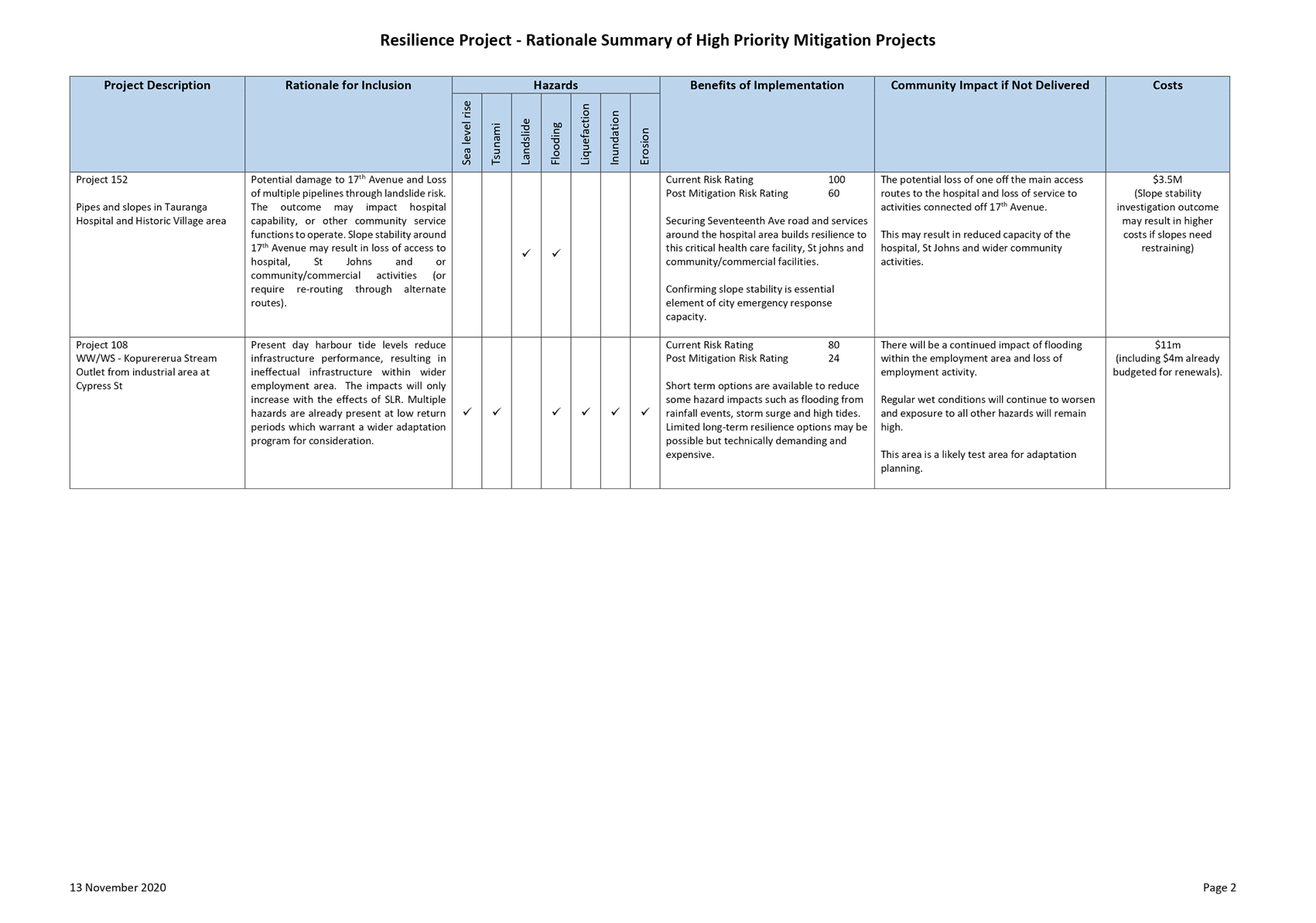
|
Urban Form and Transport Development
Committee Meeting Agenda
|
24 November
2020
|


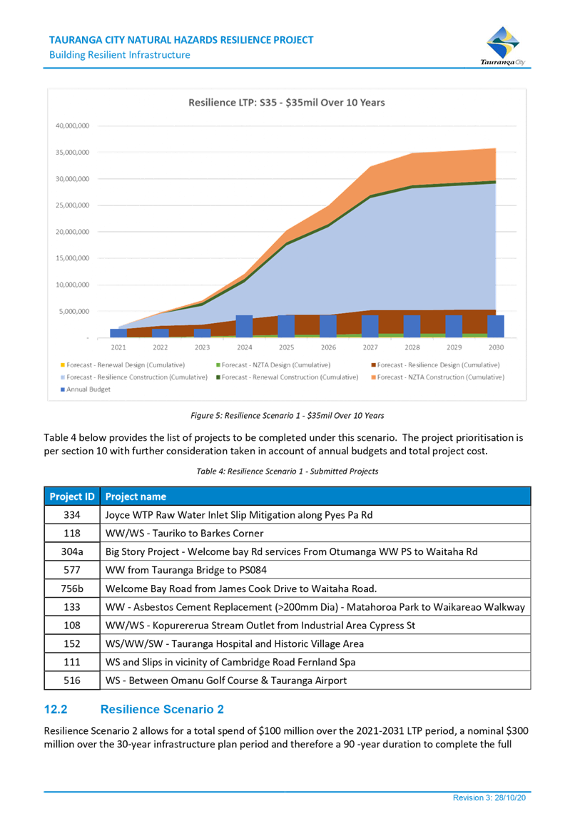


|
Urban Form and Transport Development
Committee Meeting Agenda
|
24 November
2020
|


9.5 Long
Term Plan 2021 - 2031: Urban Communities Programme - Spatial Planning
File
Number: A11900228
Author: Gareth
Pottinger, Project Leader: Urban Planning
Carl Lucca, Programme Director:
Urban Communities
Authoriser: Christine
Jones, General Manager: Strategy & Growth
Purpose of the Report
1. The purpose of this
report is to provide an overview of the proposed Spatial Planning
programme for existing urban communities, and to seek approval to
commence project planning for the Mount Maunganui / Arataki and Otumoetai /
Brookfield spatial plan areas.
|
Recommendations
That the Urban Form and Transport Development Committee:
(a) Receives the Urban
Communities Programme – Spatial Planning report.
(b) Endorses the commencement of
spatial planning for the Mount Maunganui / Arataki and Otumoetai / Brookfield
areas with staff to report back to the Urban Form and Transport Development
Committee in the first quarter of 2021 with more detail on extent, timing and
project planning.
(c) Approves future operational
and capital expenditure associated with Urban Communities Growth Programme to
proceed to the Long-Term Plan prioritisation process.
|
Executive Summary
2. In response to central
government policy direction and the outcomes of the Urban Form and Transport
Initiative (UFTI), a spatial planning programme is proposed to prepare 30-year blueprints of the strategic direction for growth of
the Mount Maunganui / Arataki and Otumoetai / Brookfield areas.
3. It is proposed to prepare
the two spatial plans in parallel with the City Plan review, acknowledging the
strategic dependencies between the two programmes.
4. Staff are seeking
approval to commence the preparation of project planning and to report back to
the Urban Form and Transport Development Committee in the first quarter of 2021
with more detail on the extent, timing and project planning for the spatial
plans.
Background
Urban Communities Growth Programme
5. Significant growth within
Tauranga continues to place pressure on existing infrastructure and resources,
including within existing urban areas and in particular those areas where
greater growth will be enabled through proposed plan changes. Integrated planning
for growth within existing urban areas provides an opportunity to plan for and
prioritise investment over the short, medium and long term, while also
responding to key challenges and opportunities.
6. Tauranga City
Council’s programme for planning for existing urban communities
(hereafter referred to as the ‘Urban Communities Growth Programme’)
builds upon sub-regional planning (i.e. the Urban Form and Transport initiative
(UFTI)) by delivering corridor based spatial planning (e.g. Te Papa Spatial
Plan) and neighbourhood and centre planning. Using a collaborative approach,
spatial plans and neighbourhood plans provide for integrated land use,
transport and social infrastructure planning, while also seeking to enhance
local culture and identity.
7. The Urban Communities
Growth Programme will seek to comprehensively plan for how areas of our city
are required to respond to central government policy and integrate with
sub-regional and local workstreams. This report focuses on the spatial
planning component of the programme (refer figure 1 below); a separate
report is provided in relation to neighbourhood planning.
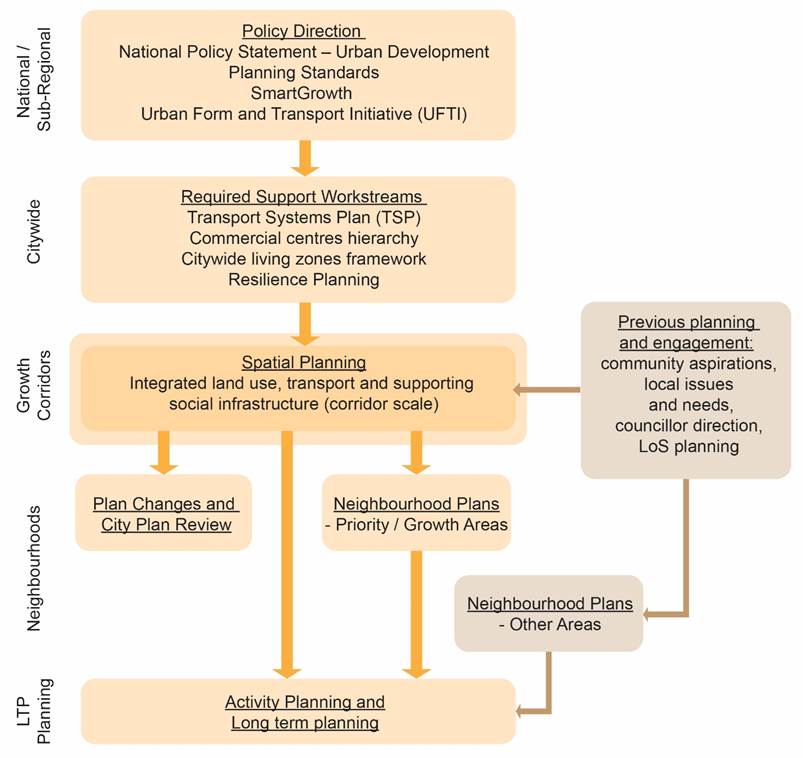
Figure 1: Urban Communities Growth Programme – Flow
chart showing spatial planning components
Purpose of Spatial Planning
8. In 2020, Council
delivered the Te Papa Spatial Plan, which developed a 30-year integrated land
use and transport plan for the Te Papa Peninsula. As the Te Papa Spatial Plan
moves into the implementation phase, the Urban Communities Growth Programme is
now seeking to prepare spatial plans for wider Mount Maunganui and Otumoetai
areas. These spatial plans will provide a response to central government policy
including the National Policy Statement on Urban Development and progress the
key moves identified within the Urban Form and Transport Initiative which were
to prepare spatial plans for the Mount Maunganui / Arataki and Otumoetai /
Brookfield areas.
9. In the same manner as the
Te Papa Spatial Plan, the spatial plans are intended to create an integrated
land use and transport network 30-year vision for the local area that connects
with the wider City, which are supported by public amenities. The spatial plans
will provide strategic direction for these matters and prepare future
implementation programmes to achieve the intended outcomes.
10. The spatial plans will provide a
comprehensive and integrated implementation plan that will respond to future
growth demands for the areas. It is anticipated that the spatial plans will
consider future land use planning, transport, culture and heritage, three
waters, open space, community facilities and urban realm. In this manner, the
spatial plans inform both strategic planning and long-term planning and
investment.
Strategic Context
11. The proposed
spatial plans (and subsequent neighbourhood plans) will respond to central and
local government strategic direction, which sets out expectations for
integrated land use and transport and supporting investment in order to achieve
wellbeing and sustainability outcomes. A summary of influencing policy on the
Urban Communities Growth Programme is provided below.
National Policy Statement Urban Development
12. Released in August 2020, the NPS-UD
seeks to ensure development of well-functioning, inclusive and better-connected
cities that reflect the diversity of their current and future communities. It
requires that Tauranga City Council enables higher-density residential
development in proximity to employment opportunities (including the city centre
and neighbourhood centres) along with existing and planned rapid transit bus
stops and where commercial activities and services are easily accessible by
active or public transport networks.
13. Spatial and neighbourhood planning
will respond to government direction by focusing on development of centres and
surrounding areas supported by public transport, active modes and improved
amenities.
National Planning Standards
14. The Government has introduced
national planning standards to provide consistency in terminology across New
Zealand. The first set of planning standards came into force on 3 May 2019.
15. The planning standards provide a
suite of residential and commercial zones which spatial plans will need to
consider and propose how these are implemented through the City Plan review.
16. Spatial planning will integrate with
the City Plan review process to identify and comprehensively plan for how these
zones could be applied.
Waka Kotahi – National Programme Arataki
17. Released in December 2019, Arataki
provides national guidance with a 10-year view of the changes needed to deliver
on the government’s current priorities and long-term objectives for the
land transport system and integrated land use at a regional level. The spatial
plans and associated projects incorporate an integrated land use transport
strategy to give specific regard to the Arataki key steps changes, including
improving urban form, transforming urban mobility, improving public health,
tackling climate change and supporting regional development.
18. The Arataki Strategy links strongly
with the abovementioned NPS-UD, providing direction on steps required to
achieve the government’s short-term priorities and longer-term outcomes,
including:
(a) Improve urban form – use
transport to improve connections between people, product and places.
(b) Transform urban mobility
– shift from our reliance on single occupancy vehicles to more
sustainable transport solutions for the movement of people and freight.
19. Spatial and neighbourhood planning
will need to strategically align with the above direction.
Key regional and local policy drivers
20. Urban Form and Transport Initiative
(UFTI)
(a) Key moves in the endorsed UFTI
business case have a significant influence on the potential outcomes of spatial
plans and strong consideration needs to be given to the potential land use and
population drivers and how these integrate with these key move processes.
Consideration of timing to lead or integrate with these is required.
21. Transport System Plan (TSP)
(a) Further business case work will
be undertaken as part of the TSP programme, including consideration of
integration between land use and transport to support desired urban form
outcomes.
(b) In some areas, the proposed TSP
Corridors may trigger the application of the NPS – UD Policy 3 regarding
land use outcomes, including implications on land use patterns and height.
(c) Integrated land use transport
planning will also allow transit hubs to be optimally located with other
uses.
22. City Visioning
(a) Anticipated to provide a set of
objectives/principles that will frame land use and transport strategies.
City Plan Review
23. The City Plan Review will provide
the strategic land use mechanism to implement the outcomes of any land use
planning outcomes identified through the spatial plans. As such, strong
integration is required between the teams to ensure there is consistency in the
strategic approach and outcomes are deliverable.
24. An important influence on the
spatial plan programme will be the outcomes of the built environment workstream
which will explore the commercial centres hierarchy of the City and the
supporting residential framework to ensure compliance with the National Policy
Statement for Urban Development. These workstreams would be the focus for
the next 6 months ahead of spatial planning commencing.
25. The spatial plan programme is being
prepared with the intention to align with the timeframes of 2024 for the City
Plan Review.
Long Term Plan Implications
26. Spatial and neighbourhood planning
will assist to inform long term planning. Early implications and assumptions
are discussion further below.
Proposed Spatial plans
27. In order to support the policy
direction of UFTI, it is proposed to progress with the two spatial plans for Mount
Maunganui / Arataki and Otumoetai / Brookfield. The draft spatial extents of
these spatial plans, indicatively identified in UFTI, are shown in figure 2
below.
28. As shown, it is anticipated the Otumoetai
/ Brookfield Spatial Plan will include the suburbs of Otumoetai, Matua,
Bellevue, Brookfield and Judea, bound by State Highway 2 to the south. The Mount
Maunganui / Arataki Spatial Plan is proposed to encompass the Mount Maunganui
suburb through to Bayfair / Arataki.
29. These spatial plan extents have a
primary focus on commercial and residential land uses. As the spatial plans
progress, these extents will be further defined through outcomes which are
dependent on the built environment workstreams of the City Plan Review. The
final proposed spatial plan extents will be brought before Council for
confirmation in early 2021.
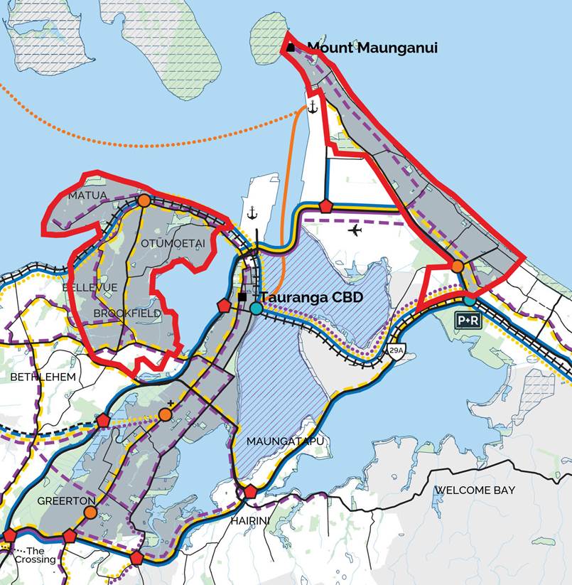
Figure 2 –UFTI - Indicative Spatial Plan boundaries
(boundaries highlighted red)
30. In preparing the Urban Communities
Growth Programme, there are several key projects and processes which require
consideration and/or integration, including:
(a) National Policy Statements
(b) City Plan Review 2024
(c) Resilience Programme including
the ongoing workstreams with Bay of Plenty Regional Council on Natural hazards
(d) Long Term Planning.
31. In order to comprehensively prepare
spatial plans, an agreed programme with project partners will need to be
established. This will include investigating the requirement for business cases
with Waka Kotahi (noting that this may already be covered through business
cases identified in the implementation plan for the TSP), along with preparing
an integrated work programme within City and Infrastructure and supporting
internal departments (e.g. Te Pou Takawaenga, Transport, Three Waters, Places
and Spaces, Community Development, City Planning, Communications etc).
32. It is considered the spatial plans
and work programme will cover the following:
(a) Land use planning including
natural hazards and resilience;
(b) Transport planning
(Integration with key UFTI and TSP actions);
(c) Three waters planning;
(d) Open space and community
facilities;
(e) Identification of significant
sites, features or values which may be but not limited to cultural, ecological,
historical or amenity;
(f) Utilities and
infrastructure planning.
33. A commercial centres hierarchy study
in early 2021 (as part of the overall City Plan review) will review and provide
recommendations to translate the existing City Plan commercial zones into the
new zone hierarchy required by the National Planning Standards (refer above).
Along with the Transport Systems Plan, UFTI, existing resilience work and the
NPS-UD, this will provide clear direction in relation to the land use pattern
for spatial plan areas, including areas likely to be proposed for higher
densities.
34. Importantly, a key component of
these spatial plans will be to establish a partnership with Mana Whenua and to
prepare a suite of principles for the area and to identify challenges and
opportunities for Mana Whenua within the areas. It is proposed to commence
regular hui as part of preparing more detailed project plans and to inform
spatial planning from the outset.
Key challenges
35. In initial scoping for spatial
plans, we are aware of a number of challenges which may need to be addressed or
responded to when preparing the spatial plans (and acknowledging that some
challenges will have higher priority in each spatial plan area).
36. A summary of identified challenges
within spatial plans include:
(a) Resilience and Natural Hazards
- Adaptation
(b) Land use (Existing interfaces,
Existing Natural features and significant landscapes)
(c) Transport
(d) Three waters infrastructure
(Stormwater)
(e) Supporting infrastructure
37. Integrating with other concurrent
work streams (e.g. Mauao Joint Administration Board, existing industrial
interfaces with other existing uses, e.g. Whareroa) will also be integral to
assisting in delivery of the spatial plans.
Proposed process and timing
38. It is proposed that the programme
integrate with key components of the City Plan Review to ensure consistency in
approach, along with key transport projects such as the Transport System Plan.
A diagram to outline how this could progress is provided in Figure 3.
39. The timeframes for the Urban
Communities Growth Programme have been prepared based on current budgets and on
prioritising the greenfield planning programme in early 2021.
40. The proposed timeframes for delivery
(refer figure 3 below) are based on the following:
(a) Integration with existing
workstreams and proceeding workstreams, e.g. the City Plan review and
commercial centres hierarchy.
(b) Prioritising the greenfield
planning programme for Te Tumu and Tauriko West in early 2021, including
resourcing.
(c) General availability of
resources. Delivery is based on proposed operational resourcing and budgets put
forward as part of the Long-Term Plan 2021-2031, as outlined further below.
Without the proposed operational resourcing and budgets, the proposed programme
will need to be reviewed.
(d) Allowing time to establish
early engagement and partnership with Mana Whenua, as well as early engagement
with other potential partners and key stakeholders.
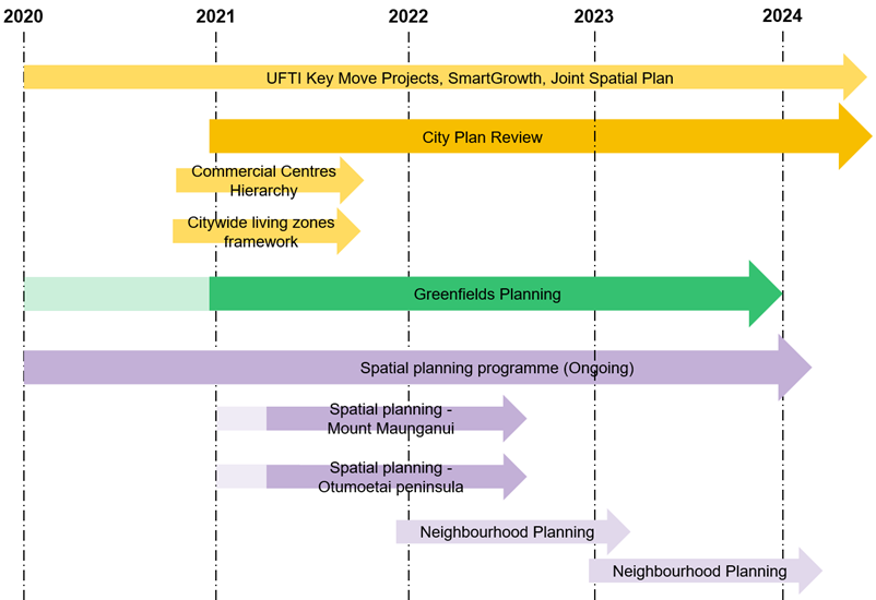
Figure 3 Proposed Integration Timeline for City Plan Review
and Urban Communities Growth Programme.
Options
41. In responding to the strategic
context and key challenges, there are a range of options which could be
undertaken to respond moving forward. These include:
42. Option 1 - Integrated City Plan
Review and Spatial Plan Programme - Recommended
43. Prepare spatial plans for the Mount
Maunganui / Arataki and Otumoetai / Brookfield areas. With a detailed project
programme to be prepared.
|
Advantages
|
Disadvantages
|
|
· Process
will support meeting strategic objectives;
· May
allow for efficiencies between workstreams;
· Will
ensure strategic alignment in policy;
· Will
inform City Plan review;
· Timeframe
will inform the next LTP.
|
· Significant
time and resource required to prepare spatial plans.
|
44. Option 2 – Progress with
One Spatial Plan
45. Progress with one spatial plan and
delay future spatial planning for one area.
|
Advantages
|
Disadvantages
|
|
· Ability
to undertake extensive urban planning and programme preparation.
|
· May
result in inefficiencies in workstreams.
· Could
not meet timelines to inform City Plan Review.
|
46. Option 3 - No Spatial Plans rely
on City Plan Review and Transport System Plan.
47. Don’t progress with any
spatial plans and rely on the outcomes of the City Plan Review and Transport
System Plan.
|
Advantages
|
Disadvantages
|
|
· More
time and resource could be allocated to City Plan Review.
|
· Would
not consider the supporting infrastructure requirements and prepare a
supporting programme for subsequent LTPs.
· May
not result in area specific solutions.
· Less
opportunity for community and stakeholder engagement.
|
Consultation / Engagement
48. The project has a high level of
significance as it directly impacts on the future development and urban form of
the city. The programme will have significant rounds of stakeholder and
community engagement. It is anticipated this would include two stages of
engagement with the community, multiple rounds of stakeholder engagement, of
which both would have Councillor involvement.
49. As part of the project, a
comprehensive communications and engagement plan will be prepared for the
spatial planning programme.
Financial Considerations
50. There are financial considerations
associated with this report, which will be put forward as part of the Long-Term
Plan 2021-2031.
51. In order to progress with the
proposed programme and timeline outlined in this report supporting operational
budget has been submitted to the Long-Term Plan in order to resource the Urban
Communities Growth Programme. This budget seeks two new FTE roles to
resource the overall Urban Communities Growth Programme, plus a 0.5 FTE fixed
term (2-year) project manager. A specific operating budget of $700,000 is also
sought within the 2021/22 period to provide for delivery of the two spatial
plans. This includes communications and engagement, transport, business case,
economic and other necessary expertise that may not be able to be resourced
internally.
52. Additionally, as part of long-term
plan process for 2021-2031, to support the future implementation of Spatial
Plans, bulk funds have been proposed within the latter years (2028-2031). These
bulk funds are intended to provide for outcomes of the spatial planning
process, which will also integrate outcomes of the TSP and other related
projects. Proposed bulk funds have been estimated based on recent projects and
anticipated requirements to support growth:
(a) Mount Maunganui / Arataki
spatial plan area – transport ($50m), open space and public realm ($20m).
(b) Otumoetai / Brookfield spatial
plan area – transport ($30m), open space and public realm ($15m).
53. The LTP development process is still
progressing and prioritisation of these activities will need to be considered
against other activities in terms of their criticality; in this regard, the
proposed timing and/or fund allocations may be pushed out and/or reduced,
respectively.
54. The bulk fund timeframes of
2028-2031 are also indicative and are dependent on outcomes of the City Plan
review and the spatial planning process, which is anticipated to further define
timeframes dependant on the outcomes of these processes. These figures will be
further refined through subsequent Long-Term Plan planning processes.
55. The Transport bulk fund has been
proposed to cover multi-modal improvements. Following detailed spatial
planning, the fund could be allocated to support potential upgrades that would
be required to support a growing community and create a safe multi-modal
transport network.
56. The open space and public realm
budget would have a similar function to improve open space dependant on future
growth considerations. Increased densities require consideration of provision of
new smaller parks (or repurpose existing spaces) particularly around town
centres, improving accessibility to the water and protection of environmental
values, improving overall public realm (e.g. streetscape), and improve quality,
accessibility and function of existing open space network.
57. The bulk fund figures have been put
forward on top of existing know project budgets contained within the LTP, as
any growth programme may need to enhance the level of service.
Significance
58. Having regard to Council’s
Significance and Engagement Policy, significance of this project is considered
‘high’. It affects a wide range of people; has moderate to high
public interest; and will have a large consequence for the city in terms of
growth over time. As outlined within this report, community, stakeholder and
mana whenua engagement will be a key component, including opportunity to
provide feedback in relation to aspects of the urban form and transport
recommendations developed as part of the Spatial Plans. Further opportunities
for engagement will also be provided through the Long-Term Plan process and
project delivery stages.
Next Steps
59. Subject to Councils approval to
progress with the Mount Maunganui / Arataki and Otumoetai / Brookfield spatial
plan areas, the next steps in this process are:
(a) Prepare a detailed spatial
planning programme and report back to the Urban Form and Transport Development
Committee in early 2021 to establish detailed timeframes and deliverables.
(b) Commence engagement with Mana
Whenua and other project partners to assist in developing the programme.
Attachments
Nil
9.6 Long
Term Plan 2021 - 2031: Urban Communities Programme - Neighbourhood Planning
File
Number: A11912699
Author: Carl
Lucca, Programme Director: Urban Communities
Gareth Pottinger, Project
Leader: Urban Planning
Authoriser: Christine
Jones, General Manager: Strategy & Growth
Purpose of the Report
1. The purpose of this
report is to provide an overview of the proposed Neighbourhood Planning programme
for existing urban communities, including agreement in principle to proposed
criteria for prioritisation of future neighbourhood planning areas.
|
Recommendations
That the Urban Form and Transport Development Committee:
(a) Receives the Urban
Communities Growth Programme - Neighbourhood Planning Report
(b) Agrees in principle the
proposed criteria for prioritisation of neighbourhood planning areas
(c) Approves operational
expenditure to proceed into the LTP prioritisation process
(d) Notes that detailed
proposals for neighbourhood planning will come before Council for approval as
the programme for planning for existing urban communities progresses.
|
Executive Summary
2. Neighbourhood planning is
intended to form part of the wider Urban Communities Growth Programme,
pre-empted by sub-regional planning (i.e. the Urban Form and Transport
initiative (UFTI)) and corridor based spatial planning (e.g. Te Papa Spatial
Plan). In general, it is proposed that neighbourhood plans will be delivered in
priority growth areas following higher level spatial planning,
responding to significant challenges and/or opportunities.
3. Over the past decade TCC
is undertaken very little in the way of neighbourhood planning and is not
currently resourced to do so. Planning has generally been focused at a
higher sub-regional, city and corridor level, or in a greenfield setting.
4. Prepared in collaboration
with the community, mana whenua, local and central government agencies, and
other key stakeholders, neighbourhood plans would be at a suburb, neighbourhood
or local centre scale, setting out:
(a) Key challenges and
opportunities facing the study area, including those identified by the
community
(b) Overall vision for the area
responding to key challenges and opportunities
(c) Further definition of land
use, movement, open space, community infrastructure, 3-waters infrastructure
and cultural outcomes proposed to respond to the issues and vision and higher
level plans
(d) An ‘implementation
plan’ outlining quick wins, short, medium and long term initiatives to
implement the proposed outcomes including, where relevant, project partners.
5. Preparation and
implementation of neighbourhood plans will require resourcing and funding to
deliver alongside broader sub-regional and city priorities; as such,
prioritisation of neighbourhood plans and related initiatives is integral to
facilitate efficient investment over time.
6. Appropriate criteria when
considering prioritisation of neighbourhood plans are recommended as:
(a) Supports and facilitates
outcomes of key sub-regional, city and related spatial plan priorities and
initiatives
(b) Supports and facilitates city
growth and/or faces significant growth pressures
(c) Local community has
significant over representation of negative social and/or economic issues
(d) Significant development
interests from public and/or private sector
(e) Opportunity for co-investment
by project partners
(f) Significant other issues
that are affecting neighbourhood / community wellbeing, such as hazard
resilience, movement or social issues
(g) Clear community interest in
moving a neighbourhood plan forward
7. Having regard to the
above, proposals for detailed neighbourhood planning will come before Council
for approval as the Urban Communities Growth Programme progresses, with a
recommendation made based on an assessment of the above criteria.
8. For those areas where a
neighbourhood plan has been proposed but does do not meet the above criteria,
alternate pathways to deliver the neighbourhood plan and/or respond to any
significant challenges or opportunities could be considered.
Background
Urban Communities Growth Programme
9. An outline of the Urban
Communities Growth Programme is provided in the ‘Urban Communities Growth
Programme – Spatial Planning’ report that proceeds this report.
This report focuses on the neighbourhood planning component of the
programme (refer figure 1 below).
Need for Neighbourhood Planning
10. Over the past decade TCC is
undertaken very little in the way of neighbourhood planning and is not
currently resourced to do so. Planning has generally been focused at a
higher sub-regional, city and corridor level, or in a greenfield setting.
11. While spatial plans like Te Papa are
at a corridor scale and set the key moves for that corridor, neighbourhood
plans are will be at a suburb, neighbourhood or local centre scale.
Neighbourhood plans may differ in their look and feel depending on the key
challenges and opportunities being responded to, e.g.:
(a) Enhancing four wellbeings
(cultural, social, environmental and economic) through relevant initiatives and
strong community input
(b) Responding to key issues
identified by the community
(c) Responding to key issues
identified by higher level plans such as UFTI and spatial planning
(d) Masterplanning in relation to
development opportunities afforded by existing ownership
(e) A combination of the above.
12. Having regard to the above, neighbourhood
plans will set out:
(a) Key challenges and
opportunities facing the study area, including those identified by the
community
(b) Overall vision for the area
responding to key challenges and opportunities
(c) Further definition of land
use, movement, open space, community infrastructure, 3-waters infrastructure
and cultural outcomes proposed to respond to the issues and vision and higher
level plans
(d) An ‘implementation
plan’ outlining quick wins, short, medium and long term initiatives to
implement the proposed outcomes including, where relevant, project partners.
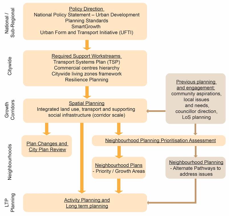
Figure 1: Urban Communities Growth Programme – Flow
chart showing spatial planning components
13. An important element of the
neighbourhood plans will be working with the community, mana whenua, key
stakeholders and project partners to understand local challenges and
opportunities. As such, meaningful engagement forms an integral part of the
neighbourhood planning process.
14. Internal collaboration between
various Council teams as well as external organisations will also be integral,
including Community Development, Spaces and Places, Infrastructure and City
Planning, Te Pou Takawaenga and other Council teams.
15. Implementation of neighbourhood
plans will require resourcing and funding to deliver alongside broader
sub-regional and city priorities; as such, prioritisation of neighbourhood
plans and related initiatives is integral to facilitate efficient investment over
time. In essence, spatial planning will identify corridor investment priorities
and areas, and the neighbourhood plans will identify the finer grain investment
required to support growth and respond to local challenges and
opportunities. Some neighbourhood plans may primarily take the form of
development masterplan type documents where there are high concentrations of
land owned by public or private developers; however, it is likely that most
neighbourhood plans would be broader in scope encompassing the four well-beings
in a local context.
Prioritising Neighbourhood Planning
16. Aspirations for neighbourhood
planning will arise from various sources, including local community
aspirations, spatial planning, development interests and through other project
processes. While neighbourhood planning may be justified in many instances,
limited resources and funding requires prioritisation. In addition, there may
be other avenues for responding to the key challenges or opportunities being
identified.
17. Having regard to the above, key
criteria for the prioritising of neighbourhood plans is recommended as follows:
(a) Supports and facilitates
outcomes of key sub-regional, city and related spatial plan priorities and
initiatives
(b) Supports and facilitates city
growth and/or faces significant growth pressures
(c) Local community has
significant over representation of negative social and/or economic issues
(d) Significant development
interests from public and/or private sector
(e) Opportunity for co-investment
by project partners
(f) Significant other issues
that are affecting neighbourhood / community wellbeing, such as hazard
resilience, movement or social issues
(g) Clear community interest in
moving the neighbourhood plan forward.
18. Weighting of criteria may vary
depending on the significance of the challenges and opportunities. The purpose
of the criteria-based approach is to enable an objective assessment to be made
in the context of limited resources and funding.
19. Subject to further assessment and
reporting to come before Council in 2021, based on the above criteria and
outcomes of the Te Papa Spatial Plan, the following areas are likely to be key
priorities over the next 0-5years:
|
Neighbourhood
Plan Area
|
Criteria (refer above)
|
|
|
(a)
|
(b)
|
(c)
|
(d)
|
(e)
|
(f)
|
(g)
|
|
City Centre
|
ü
|
ü
|
|
ü
|
ü
|
|
|
|
Gate Pā /
Pukehinahina / Hospital
|
ü
|
ü
|
ü
|
ü
|
ü
|
|
ü
|
|
Merivale
|
ü
|
ü
|
ü
|
ü
|
ü
|
|
ü
|
20. Other areas are also likely to be
identified through proposed spatial planning processes and/or other council
processes and departments for consideration (refer figure 1). It is recommended
that these areas be brought before Council as part of the above reporting or,
subsequently, on a case by case basis.
Areas not meeting Prioritisation Criteria
21. For those areas where a
neighbourhood plan has been proposed but does do not meet the prioritisation
criteria (or otherwise considered a high priority), alternate pathways to
deliver the neighbourhood plan and/or respond to any significant challenges or
opportunities could be considered.
22. Recommendations will consider the
specific challenges and opportunities within the neighbourhood area, including
the overall context and breadth of issues. These may include:
(a) Recognition of priority albeit
in a longer-term timeframe, funded through future long term planning
(b) ‘Community
Funding’ applications to fund community led neighbourhood planning
(c) Addressing challenges and
opportunities through existing projects, e.g. such as already funded transport
or community infrastructure projects
(d) Establishment of new projects
to focus on the core challenges or issues raised.
Timing
23. It is noted that timing and delivery
of neighbourhood plans will also be recommended in relation to wider
dependencies, particularly:
(a) Co-funding opportunities
(b) Willingness of potential
project partners to move forward and collaborate on neighbourhood planning
(c) Availability of Council
resources over various teams
(d) Willingness and readiness of
community to engage in the project
(e) Timing alongside other
projects and engagement.
24. It is estimated that neighbourhood
planning, including community engagement, will take approximately 12 to 18
months for each area. Acknowledging the upcoming spatial planning
programme over the coming 18 months, and taking into account proposed LTP
operational budgets, it is proposed that neighbourhood planning commence in
mid-2021, with 6-8 neighbourhood plans to be delivered over the course of the
LTP. The final delivery programme will depend on the overall prioritisation
process and complexity of the areas being considered.
25. Delivery is based on proposed
operational resourcing and budgets put forward as part of the Long-Term Plan
2021-2031, as outlined further below. Without the proposed operational
resourcing and budgets, the proposed programme would need to be reviewed.

Figure 2: Proposed Integration Timeline for City Plan Review
and Urban Communities Growth Programme.
Strategic / Statutory Context
26. The proposed neighbourhood plans
build on the spatial planning and overall Urban Communities Growth Programme,
including the strategic context of these. A full outline of the strategic
context is provided in the ‘Urban Communities Growth Programme –
Spatial Planning’ report that proceeds this report.
Options Analysis
27. In responding to the key challenges
and strategic context, there are a number of options which could be undertaken
to respond moving forward. These include:
28. Option 1 – Neighbourhood
Plan Criteria Based Prioritisation, as outlined within this report
|
Advantages
|
Disadvantages
|
|
· Efficient
planning and use of resources, including long term plan funding and internal
resourcing, that responds to areas most in need and likely to support growth.
|
· Perceived
neglect of some areas over others.
|
29. Option 2 – Neighbourhood
Planning on ad hoc basis (status quo)
30. Neighbourhood planning is undertaken
without any prioritisation method but rather based on ad hoc requests arising
through other processes and/or identified issues.
|
Advantages
|
Disadvantages
|
|
· Nil
|
· Inefficient
planning and use of resources, including long term plan funding and internal resourcing.
· Potential
that areas most in need and with highest growth potential are not
prioritised.
|
Consultation / Engagement
31. Neighbourhood plans will have a high
level of significance as it directly impacts on the neighbourhood’s local
communities; accordingly, all neighbourhood plans will include significant
stakeholder and community engagement. As part of any future neighbourhood plan,
a comprehensive communications and engagement plan will be prepared as part of
the overall project planning.
Financial Considerations
32. There are financial considerations
associated with this report, which will be put forward as part of the Long-Term
Plan 2021-2031.
33. In order to progress with the
proposed programme and timeline outlined in this report supporting operational
budget has been submitted to the Long-Term Plan in order to resource the Urban
Communities Growth Programme. This budget seeks two new FTE roles to
resource the overall Urban Communities Growth Programme, plus a 0.5 FTE fixed
term (2-year) project manager (noting these FTEs are for both Spatial Planning
and Neighbourhood Planning, as outlined in the previous Spatial Planning
report). Additionally, a specific operating budget of $150,000 per annum is
sought throughout the 2021-31 period to provide for delivery of neighbourhood
planning as outlined in this report (and including further planning for the
city centre). This includes communications and engagement and other necessary
expertise that may not be able to be resourced internally.
34. Additionally, and as outlined within
the ‘Urban Communities Growth Programme – Spatial Planning’
report that proceeds this report, as part of long-term plan process for
2021-2031, to support the future implementation of Spatial Plans, bulk capex
funds have been proposed within the latter years (2028-2031). These bulk funds
will also assist in delivery of neighbourhood planning outcomes where
appropriate.
Significance
35. Having regard to Council’s
Significance and Engagement Policy, significance of neighbourhood planning is
considered ‘high’. It affects a wide range of people; has moderate
to high public interest; and will have a large consequence for the city in
terms of growth over time. Community, stakeholder and mana whenua engagement
will be a key component, including opportunity to provide feedback in relation
to aspects of the urban form and transport recommendations developed as part of
the neighbourhood plans. Further opportunities for engagement will also be
provided through the Long-Term Plan process and project delivery stages.
Next Steps
36. Subject to Council’s approval
of the recommendations within this report, next steps will be to report back to
Council on proposed prioritisation of neighbourhood planning against assessment
of criteria, including updates in relation to other related projects and
dependencies (including partners). Further reporting is likely to be in the first
quarter of 2021.
Attachments
Nil