6 Business
6.1 Links
Avenue Trial Update
File
Number: A13164399
Author: Brendan
Bisley, Director of Transport
Andy Vuong, Programme Manager
- Cycle Plan Implementation
Authoriser: Nic
Johansson, General Manager: Infrastructure
Purpose of the Report
1. The purpose of this report
is to provide an update on the cul-de-sac trial that was carried out in Links
Avenue in November/December 2021 and to provide recommendations for the next
phase.
|
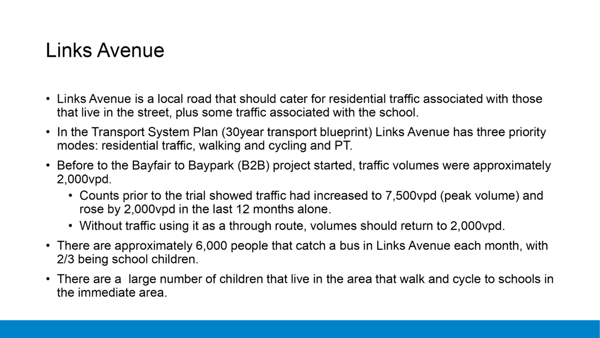
Recommendations
That the Council:
(a) Receives the report on the
cul-de-sac trial that took place in Links Avenue
(b) Approves a further trial of
a cul-de-sac on Links Avenue at the Concord Road end for a minimum period of
4 months. Staff are to gather data and report back to Council regarding
recommendations on a permanent solution prior to the trial being removed.
(c) Approve the trial resurface
Links Avenue (chipseal) and removing the existing bus lane in the process for
the duration of the trial.
(d) Endorses a temporary
30km/hr speed limit along the length of Links Avenue for the duration of the
trial and appropriate traffic calming measures installed to ensure traffic
speeds are kept low.
(e) Approve Council staff
engaging with the residents on Links Avenue and the streets that have direct
access off it regarding the street layout for Links Avenue if traffic volumes
were able to be reduced to a level that a bus lane was no longer required.
|
Executive Summary
2. Council
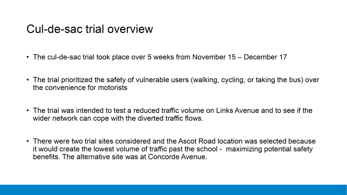
undertook a trial of a cul-de-sac on Links Avenue in November/December 2021 for
a period of 5 weeks. The trial was intended to see if reducing the traffic
volumes on Links Avenue would improve safety for the vulnerable users to get to
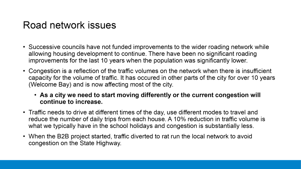
and from the schools in the area. The other purpose of the trial was to test
the capacity of the wider transport network to cope with the changed traffic
flows.
3. The
trial was implemented following an independent review in March/April 2021
identified that there was an unacceptable level of risk for vulnerable users
along Links Avenue. In the case of Links Avenue, these users are predominately
the school children that walk and bike to get to and from the schools in the
area.
4. The
trial purposely prioritised the safety of the vulnerable users over the
convenience of having the road open to traffic and it being used as a third
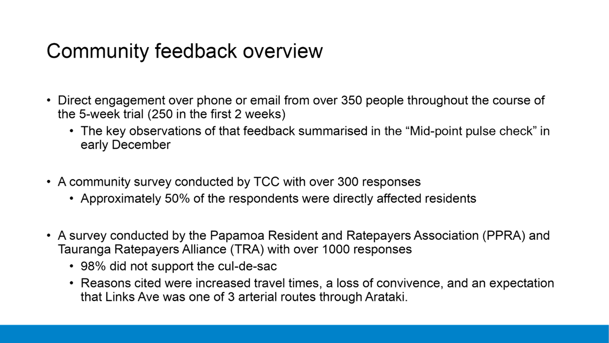
route to get through the Arataki area.
5. The
trial achieved its intended purpose and did reduce the traffic volume on Links
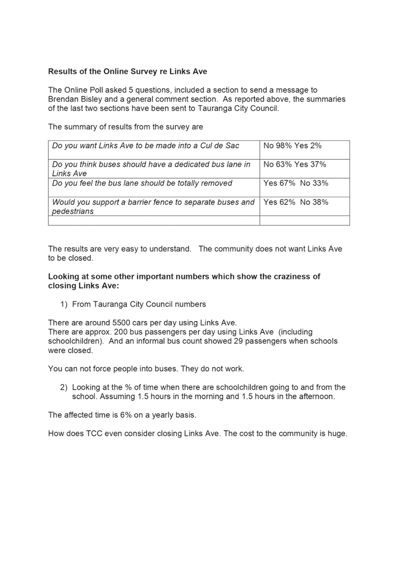
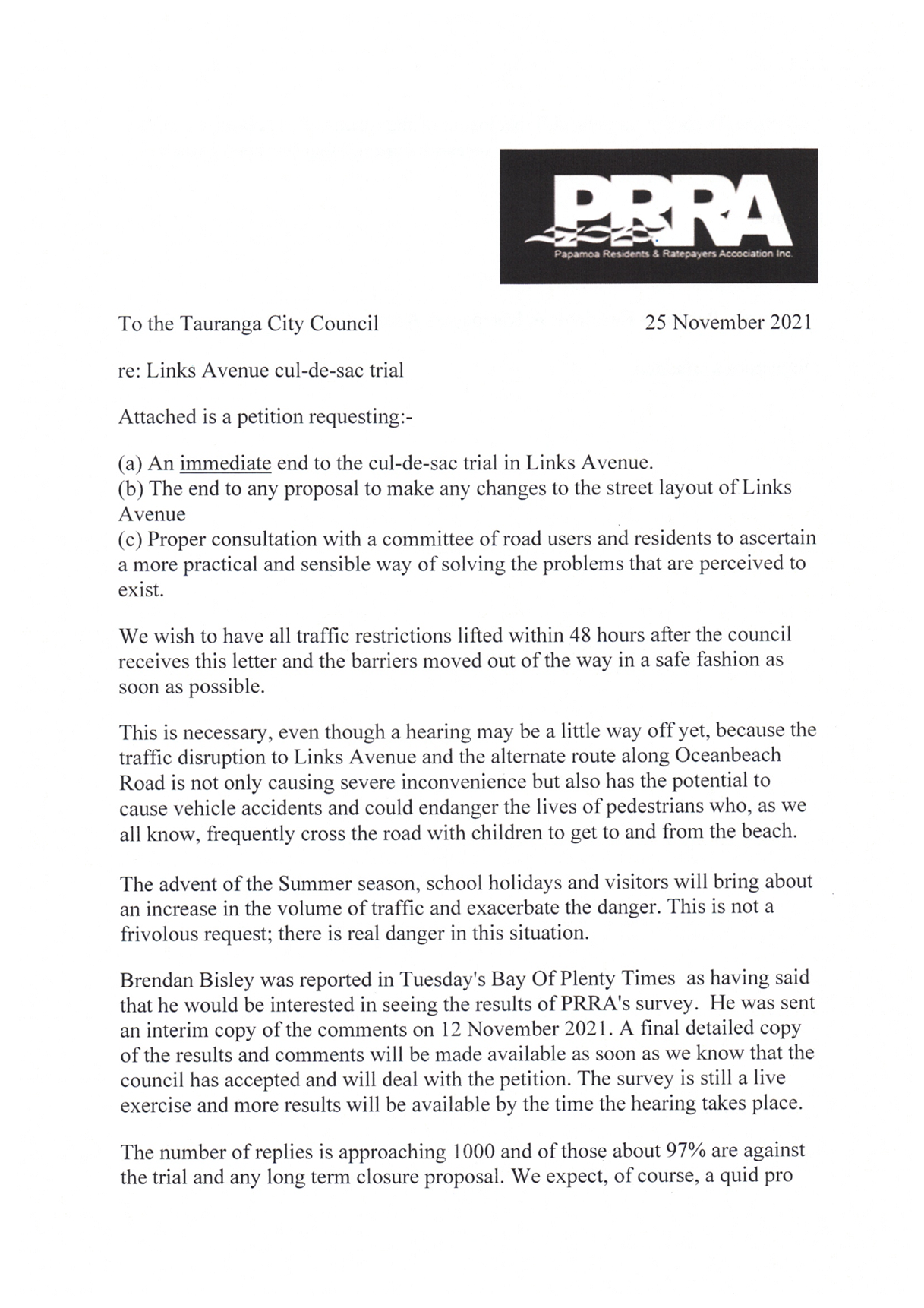
Avenue significantly. Additionally, the trial showed the traffic network was
able to cope with the increased traffic flows. Travel times in the
monitored sections were <1m in the morning peak and 2-4minutes in the
evening peak compared to those that were being recorded prior to the trial.
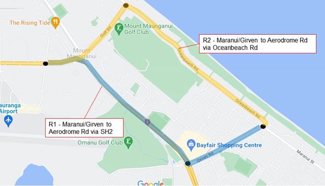
6. In
advance of the trial, Council undertook traffic counts on surrounding streets
and installed some monitoring equipment that recorded travel times along
defined routes. The monitoring equipment uses blue tooth signals from cell
phones and other equipment. It is able to data-match the signal to record
the time the vehicle enters and exits the route and therefore calculates a
journey time. Traffic counts were also taken during the trial period so we can
accurately record the change in traffic volumes on the network.
7. The
traffic counts undertaken by Council prior to the cul-de-sac showed that peak traffic
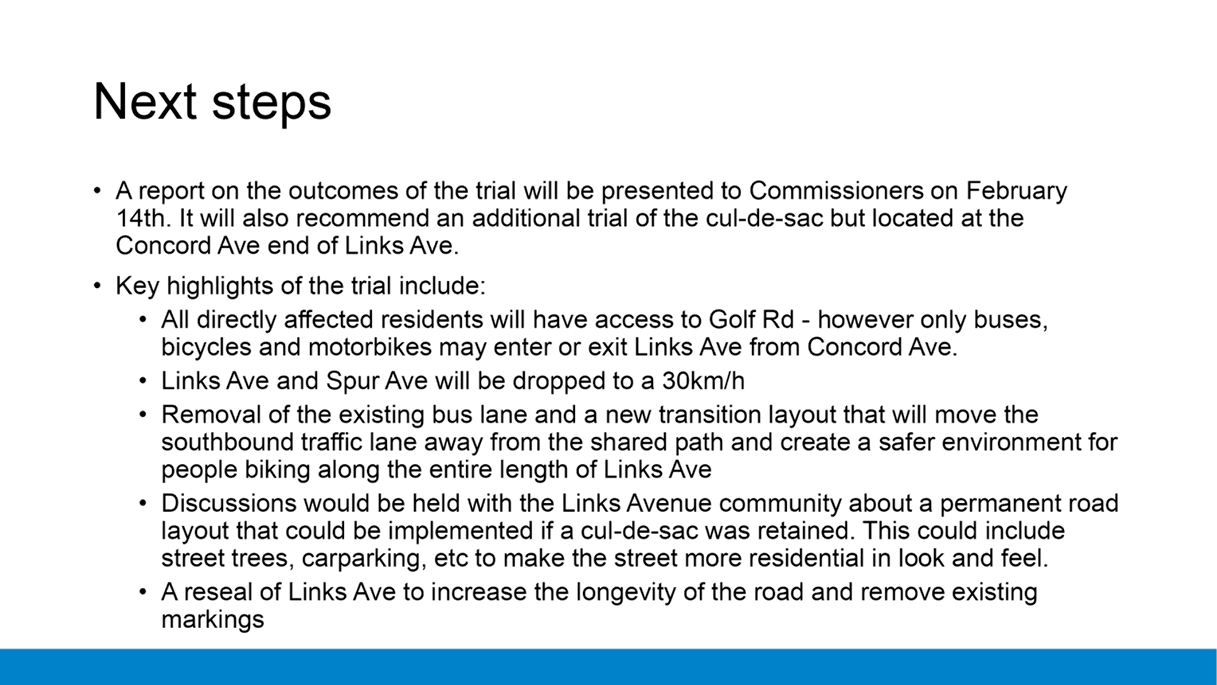
volumes on Links Avenue have increased from approximately 5,500 vehicles per
day (vpd) to 7,500vpd. This is an increase of 2,000vpd in 12 months and now has
the traffic almost 4 times what it was prior to the Bayfair to Baylink project
starting construction. This increase is not related to residents living on the
street but is through traffic using it as a convenient alternative route to
avoid congestion elsewhere. This additional traffic increases the risk of a
serious or fatal accident occurring on Links Avenue.
8. The
location of the cul-de-sac did impact on residents who lived at the eastern end
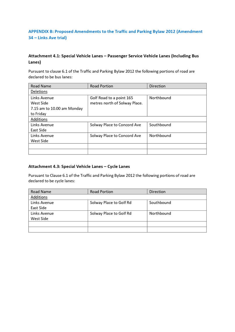
of Links Avenue and in Ascot Avenue and the cul-de-sac’s that come off
both as they were unable to use Links Avenue to access Golf Road.
9. There
was significant feedback from the wider community about the loss of Links
Avenue as a through route, with the majority of submitters concerned about
their travel time rather than the safety changes trying to be achieved.
10. With
the trial, due to its short time being in place, the road layout in Links
Avenue was not changed except at the cul-de-sac location. This meant:
· that
the vehicle lane remained very close to the shared path,
· the
bus lane remained in the street,
· the
public were not able to see what could be achieved with the road layout if the
traffic volumes were permanently lower,
· the
bus lane remaining, as well as the location at Ascot Avenue, impacted on some
resident’s perception of what was being achieved with the trial,
· the
trial was not long enough to get residents and motorists in the wider catchment
to consider alternative routes, travel modes, or travel times.
· the
majority of the traffic simply tried to use Oceanbeach Road and increased the
traffic queues,
· the
dispersion of traffic through alternative routes or changed travel times that
would occur in a longer trial.
11. The
trial shows that a cul-de-sac does successfully lower the traffic volumes in
Links Avenue and reduce the risk for vulnerable users. The cul-de-sac options
addresses the risk identified in the Safe System review and would provide an
opportunity to change the layout of Links Avenue to reflects its residential
nature if it was permanently implemented.
12. A
further trail of a cul-de-sac should be undertaken for a longer period, at an
alternative location nearest to Concord Avenue. The alternative location will
(a) allow
assessment on its impact on traffic volumes in Links Avenue past the shared
path to ensure they remain low enough to maintain safety compared to the
original location at Ascot Avenue,
(b) allow
the residents in Links Ave and surrounding streets to assess the impact on
their vehicle trips in the area by having access to Golf Road,
(c) allow
Council to reseal the road and temporarily remove the bus lane to allow
residents to see what can be achieved in the street layout without a bus lane,
and
(d) allow
time for the wider community to change driving behaviours so we can more
accurately assess its impact on the surrounding network.
Background
13. Council
implemented a trial of a cul-de-sac treatment in Links Avenue, near the western
end of Ascot Avenue to trial a reduction in traffic volumes to see if this
would improve safety for vulnerable users on Links Avenue. This trial was in
place for 5 weeks in November/December 2021.
14. The
trial was implemented after a Safe System review completed in identified that
there was a risk of a vulnerable user being involved in a serious or fatal
accident. The trial deliberately put safety for vulnerable users as a priority
over the convenience aspect for the motorists using it as a through route. This
meant residents in the wider Papamoa and Mount areas may have longer journey
times with the increased traffic volumes on the network.
15. Links
Avenue is designed as a residential street with a large intermediate school
approximately 1/3 of the way along its length. In addition there is a sports
field at the western end.
16. Residential
streets are intended to cater primarily for the residents that live in the
street and is used as the way they get to and from their house and connect to
the wider roading network. A residential street typically has carparking on
street and has opportunities to have street trees and other amenity available.
17. Prior
to the Bayfair to Baylink (B2B) project starting, Links Avenue had
approximately 2,000vehicles per day (vpd) and the traffic was primarily
residents that lived on Links Avenue or the streets that came off it, and some
traffic associated with the school. At this volume it is generally considered
that vehicles and cyclists can safely share the road.
18. When
the B2B project started, traffic volumes increased as traffic sought
alternative routes to avoid the congestion associated with the construction
activity. The most recent traffic counts show traffic volumes on Links Avenue
are up to 7,500vpd and have increased by 2,000vpd over the last 12 months. This
is almost 4 times the traffic volume and it appears it will continue to climb
until the B2B project is finished. We estimate that volumes could be closer to
9,000vpd in 12 months’ time if no changes are made.
19. Links
Avenue has a shared path constructed along the school side between Golf Road
and Ascot Avenue. This is well used by vulnerable users and during the morning
and afternoon peak period is very busy with large groups of school children
waiting to catch the bus as well as students walking and riding along the path.
Council is aware of incidents where the congestion on the path has led to
accidents and collisions. The congestion also causes some bike riders to remain
on the road or to use a section of the road to get past groups of students.
20. Council
operates an education programme with the schools in the area and train the
students how to use the shared path. This helps to reduce the risk, but the
volume of users as children head to and from the three schools in the area
means other measures are necessary to reduce this risk to an acceptable level.
21. Bus
services were moved to Links Avenue to improve safety for users as it was very
difficult for bus users to cross a 4-5 lane arterial road that has speed limits
of 70km/h in places. The previous location also made it less likely people
would catch the bus. In addition, with the congestion around the roadworks, bus
journey time reliability was an issue which meant that buses were a less
attractive option for residents.
22. When
the buses were first using Links Avenue, they shared the vehicle lanes as the
volumes were low enough that their reliability was not significantly impacted.
As the traffic volumes on Links Avenue increased, the bus journey time
reliability deteriorated, and the bus lane was installed. This pushed the other
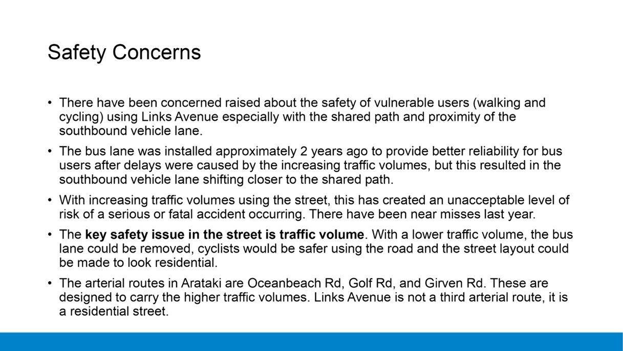
vehicles lanes across and resulted in the vehicle lane running beside the
shared path which provides little buffer to the shared path.
cause of the safety Issues in
Links Avenue
23. There
has been significant debate from the public regarding what is causing the
safety issues in Links Avenue. A lot of focus from members of the community
over the last 2-3years has been focused on the bus lane. There is a view
that removing the bus lane and the buses from Links Avenue will make the street
safe and no further changes would be required. Others consider that the
convenience of the street as a through route is the most important aspect, and
there are no safety issues that need to be addressed.
24. The
core issue that is creating safety issues on Links Avenue is the traffic
volume.
25. When
considering safety, people make mistakes. The road network should be safe
enough that if a mistake is made, it does not result in death or serious
injury.
26. A
safe road network has four guiding principles:
· People
make mistakes and crashes are inevitable. We can’t stop all crashes.
· The
human body has a limited ability to withstand crash forces, so we need to
minimise the chances of a crash.
· Designers
and users of the road must all share responsibility for managing crashes, so
they don’t result in serious injuries or fatalities
· It
takes a whole system approach to get a safer network, it’s not just
changing one element like better crash protection in vehicles, building more
crash barriers, or lower speed limits etc.
27. In
Links Avenue, the high traffic volume means that it is not safe for people
biking to share the road with vehicles as the chances of a conflict are high.
For cyclists to be able to safely share the road with vehicles, recommended
traffic volumes are less than 1500vpd with a 30km/hr speed limit. In the
case of Links Avenue, we need to reduce the traffic volumes back to what was
prior to the B2B project which is why the cul-de-sac was trialled. The other
options presented in the staff option report in October 2020 do not lower the
traffic volumes.
28. In
relation to accidents, a cyclist or pedestrian being struck by a car, SUV or
Ute travelling at 50km/hr is also likely to result in a serious injury or fatal
accident which is why a lower speed limit is required. Simply removing buses
will not reduce the risk of a serious or fatal accident from occurring as an
accident involving a modern large motor vehicle is also likely to have a
similar outcome.
Longterm Plan for Links Avenue
29. The
TSP project reviewed the transport network across the city and identified what
were the primary function of roading corridors over the next 20years plus. TSP
identified routes that were intended to accommodate vehicle movement, freight
movement, Passenger transport and walking and cycling routes. This work was
undertaken in 2019 and 2020 and approved by Council in 2020.
30. As
part of this review, Links Avenue was identified as a key corridor and the
modes that were prioritised for Links Avenue are walking ad cycling and
passenger transport. Vehicle movement was not prioritised, and its function
remained as a local road, and therefore it is not intended to be a third
traffic route through the Arataki Area.
31. Walking
and cycling was prioritised due to the presence of the schools in the area, its
connection to the wider Area A cycleway planned to be constructed and the
residential catchment. The passenger transport was prioritised due to the high
number of students and residents that get on and off bus services in Links
Avenue. There are approximately 6,000 passenger trips a month that use the bus
services from Links Avenue.
32. Links
Ave will always cater for the traffic associated with the residents that live
on the street and the streets that come off it, but it is not intended to cater
for rat running traffic using it a s a convenient shortcut to avoid congestion
elsewhere on the network.
Transport Network
33. In
a city the size of Tauranga, with our topography and growing population, our
transport network will need to constantly change to keep up. 20-30 years ago,
the smaller population that lived and worked in Tauranga resulted in relatively
low traffic volumes and residents were able to move around the city relatively
freely. As the Port activity and industry has increased and the population has
increased, the city has gradually got more congested and is now at a point
where there is simply not enough capacity in key corridors. During the key
holiday periods with the additional numbers of visitors this situation gets
worse.
34. The
outcome of this is we have more congestion and delays. Drivers start to
take smaller gaps in traffic and don’t look for cyclists, motorcyclists
etc. Buses are less reliable as they are also stuck in the congestion and
have to wait longer as they need larger gaps to turn.
35. The
transport system is now at a point where it needs to adapt to the size and
nature of the city and the way we move around the city needs to change to
enable the city to continue growing as planned.
36. Tauranga
is at a position where we are unable to ‘build’ our way out of the
issues with traffic. Simply building a new harbour bridge or widening Turrett
and 15th Avenue, as examples, will not solve the congestion issues
as there are now so many issues across the network that fixing a single
location does not create the extra capacity. Also, land values have increased
significantly so the cost of purchasing land is prohibitive and it also reduces
the number of houses for residents to live in.
37. The
focus for the future needs to be based around improving safety for users of the
transport network (a Safe System approach) to reduce the number accidents
occurring, increasing the number of residents that move around the city on
modes other than private cars, and undertaking roading improvements that
improve traffic flows. This will ensure that those that need to move by vehicle
have less congestion and the transport system can accommodate the ongoing
growth. This will improve economic activity in the region, reduce carbon
emissions in the long-term and provide a better quality of living for residents
by reducing the time they are spending in traffic queues.
A Safe System Approach to the
Transport Network
38. A
safe system approach is one where a road is designed to ensure that if someone
makes a mistake there shouldn’t be a serious or fatal accident as a
consequence. We all make mistakes at times due to in attention, tiredness, etc
and therefore the transport system should be able to accommodate those times
without significant impacts. In a safe system approach, the road layout is
designed to prioritise safety and protecting those using it.
39. Other
considerations for a road, such as travel time, access etc are still
considered, but may be compromised to achieve the safety outcomes needed first.
40. Over
the last 10 years, there have been 12 fatal accidents in Tauranga city, 10 of
those fatalities were either pedestrians or cyclists that were killed. In
addition there were a further 95 injury accidents in the same period. The cost
to society of these crashes was $175m, but there are also lifelong trauma from
the injuries sustained and the impacts of the wider whanau from lost loved ones
who were killed.
41. Waka
Kotahi, Auckland Transport, Hamilton City and several local authorities have
implemented a safe system approach on their network, and it is something
Tauranga City should formally adopt for their roading network to reduce the
number of serious injury and fatal accidents that occur.
The Community Conversation
regarding Transport in Tauranga
42. The
residents of Tauranga often raise congestion and delay as a significant issue
in Council surveys and in complaints and correspondence with the Council. Over
the last 10-15 years congestion has increased at the same time as there has
been an under investment in maintaining the capacity of the network. In
addition, large scale housing and commercial development has continued, with
significant development in the Pyes Pa/ Lakes/Tauriko and the Papamoa areas
which has added more traffic volume.
43. When
the rapid growth of the city first started, there was spare capacity in the transport
network, so the congestion was relatively minor, but as the growth has
continued that spare capacity/buffer in the transport network that was
available has been used up and now the network is struggling to cope with the
traffic volumes in the peak hours.
44. A
traffic lane can only move a certain number of vehicles per hour, and once that
limit is reached, the traffic forms queues and these get longer as more
vehicles try and get through. Intersections and traffic turning into and out of
side streets reduce the volume a lane can move. The first areas of the city to
experience this congestion issue were Welcome Bay, Hairini, Ohauiti and
Maungatapu. The same issues are now being seen across the city as the
housing growth has continued and more people live in the city.
45. As
the city continues to expand the congestion will get worse, the number of hours
the congestion exists will extend and the queue lengths will increase.
46. The
TSP investment (approximately $4billion over the next 20 years) will not
improve the existing congestion at a citywide level, it will only prevent it
getting worse. Some parts of the city will see some improvements, but the
additional traffic flows from the Takatimu Northern Link in 5 years’ time
for example, will simply use any additional capacity that can be built into the
15th/Turrett Road corridor in the peak hours. Another example is the
B2B project, while it will initially improve traffic flows in the Arataki area,
future housing growth in Te Tumu area will result in congestion increasing
through the area again in the future.
47. The
TSP investment programme will take 20 years to be fully delivered as we
can’t have all of the key corridors under construction at the same time
and the approval process for Crown funding through business cases etc takes
time. Therefore, we need to implement additional measures to reduce traffic
volumes if we want to reduce traffic congestion.
48. A
key way to reduce the congestion are to get those that can to use alternative
modes to travel around the city. Alternative modes are walking, cycling
and passenger transport. As an example of how effective this could be, during
the school holidays traffic flows significantly easier and there is less
congestion. The difference in traffic volume is only 10% typically, but that
10% reduction stops the roads being overloaded and as a result the traffic can
flow. If we had 10% of the population using alternatives modes to travel we
could achieve a reduced level of congestion year-round rather than just during
the holidays.
49. The
other ways to reduce congestion would be to have residents travel at different
times rather than the majority trying to travel in the peak hours. Alternatives
would be carpooling, increased housing density closer to where people work and
play rather than the city continuing to spread etc.
50. Reducing
the congestion will allow those that are dependent on vehicles to be able to
move freer and for businesses etc that have tradespeople moving across the
city, can get more work done in the day which lowers costs for travel time
charges etc. It would also provide more reliable freight delivery times to and
from the Port and other key business areas across the city.
51. The
other key change that would make a difference is residents thinking about the
number of trips they make in a day. Residents are unhappy with the congestion
but don’t always recognise that they are part of creating that
congestion. In feedback from the community during the Links Avenue trial, a lot
talked about their need to travel to and from their houses multiple times per
day for various activities or to accommodate exercise etc. Each of those trips
adds to the total volume of vehicles trying to use the roads. The feedback was
reflective of people expecting the road network to allow them to live like they
could in a smaller regional centre, rather than a city that has limited road
corridors due to the topography and the harbour.
52. The
other change that needs to happen is the road layout on our busier roads and
arterials. In a lot of cases the current street layout is more reflective of a
local road with the availability of on street carparking in preference to bike
lanes, safe crossing points for pedestrians or additional lanes. To ease
congestion Council needs to review these busier road and arterial street
layouts across the city and prioritise safety and movement of people over the
convenience of on-street carparking.
53. A
conversation with the community needs to be started to talk about the big picture
of what Tauranga will look like in the next 5 to 10 and 20 years and beyond,
why the transport system needs to change as discussed above. At the same time,
a review will be undertaken of all the key corridors and changes implemented to
get better movement to get some early improvements while the larger projects
that will be delivered by TSP are built.
Community feedback from the
Trial
54. There
was a large amount of feedback from the community during and after the trial.
In the first two weeks alone, over 250 calls and emails had been catalogued and
responded to, eventually reaching over 400 by the end.
55. In
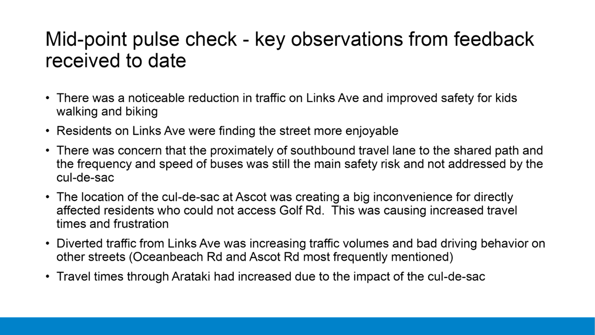
early December, a mid-point pulse check was provided to the community with key
observations of the feedback that had been provided thus far:
(a) Improved
Safety
(i) Links
Avenue is quieter and the sense of safety for children has improved during the
operation of the cul-de-sac trial.
(ii) Lower
traffic volumes are returning the feel of a residential street rather than a
through-route.
(b) Buses
(i) Buses
are still perceived by most as the greatest risk to pedestrians and cyclists on
Links Avenue, and that the bus lane should be removed.
(ii) There
remains a high number of buses and they seem to travel too fast. This increases
risk to the users of the shared path, due to the lack of a grass verge or
buffer between the path and the general traffic lane.
(c) Community
Impacts
(i) Directly
affected residents
(1) More
residents did not support the cul-de-sac at Ascot Road than those that did due
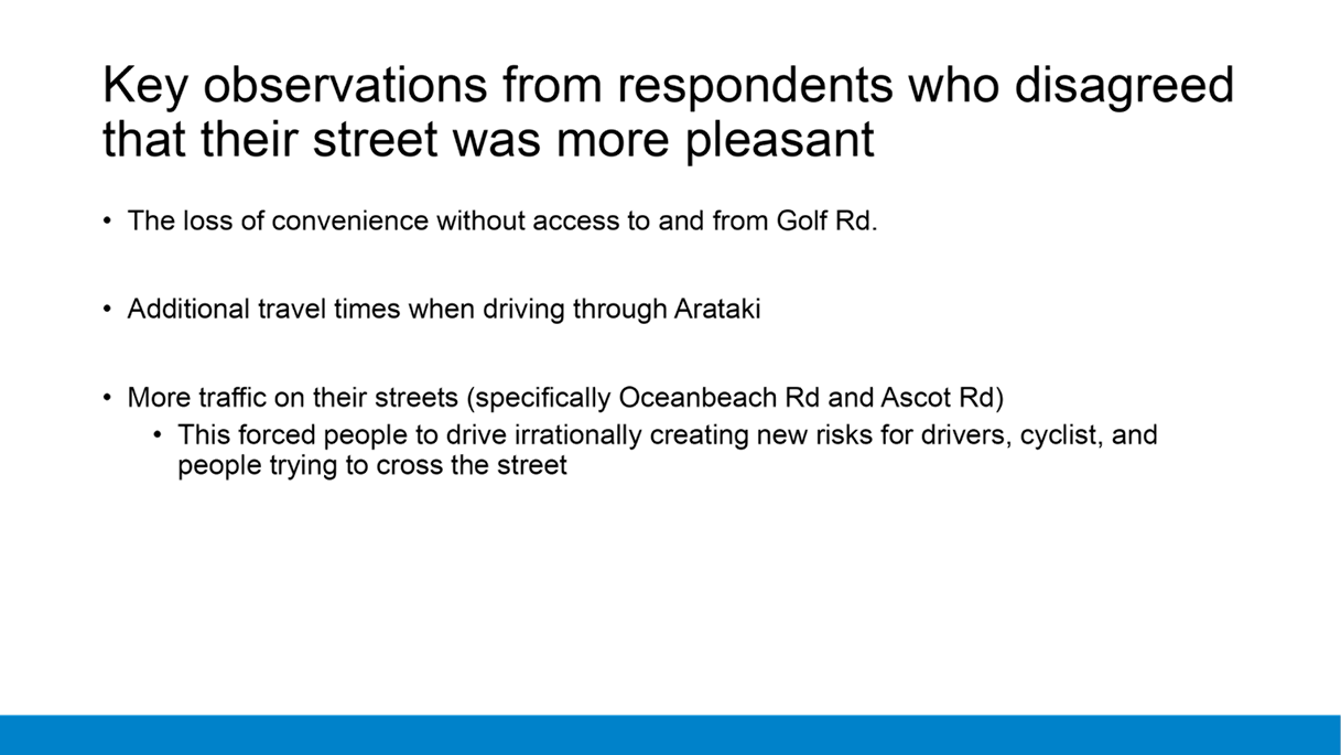
to the impact on travel time, and most importantly access to Golf Road.
(2) Ascot
Road has also become busy in the morning, with cars stopping at inconvenient
locations, looping back or doing U-turns after dropping children at school.
(3) Many
residents suggest a better location for a cul-de-sac would be towards the
Concord Avenue end of Links Avenue. This would reduce the impact on residents
who could use Spur Avenue to head towards Bayfair and open up access back to
Golf Rd.
(ii) Wider
community
(1) It
was clear that this group did not support the cul-de-sac at all due to its
impact on the wider transport network.
(2) There
is an expectation that Links Avenue is one of three arterial routes towards the
Mount and Tauranga with additional travel times and delays as the primary
complaints.
(3) There
were observations by a few that safety for pedestrians and cyclists was not an
issue on Links Avenue and diverted traffic on other streets was now
compromising safety for drivers and active travel users.
(iii) Hours
of operation
(1) There
were requests that the cul-de-sac operate only during the hours when the
presence of children on Links Avenue peaks (8–9:30am and 3–4:30pm).
56. Two
surveys were conducted by Council at the end of the trial.
(a) A
survey that targeted students, parents of students, or teachers who attended
either Omanu Primary, Mount Intermediate, or Mount College.
(i) Due
to the evolving Covid-19 situation at the time of the planned survey launch, it
was not possible to directly engaged with the students as planned. Instead, the
survey was posted via the schools’ Facebook page after the school term
had ended.
(ii) This
resulted in nearly 550 responses overall, but only 9% from students overall and
4% from students who walk, bike, or take the bus to school. As a
comparison – the percentage of students who walk, bike, take the bus to
school on a regular basis is closer to 70%.
(iii) The
main findings confirmed the feedback summarised in the mid-point pulse check:
(1) Some
people noticed improvements on safety, but many felt the proximately and speeds
of the buses that use Links Ave continued to be a safety risk
(2) The
cul-de-sac increased travel times when using the wider travel network and
specifically those who drive their kids to multiple schools
(3) The
additional traffic on Oceanbeach Road was creating anxiety for those driving
and additional safety risks for those who cycle on it or trying to walk across
it.
(b) A
survey available to the entire community but targeted directly affected
residents and those who had provided prior feedback or expressed interest in
the trial.
(i) About
300 people responded to this survey (it is unknown how many people responded to
both surveys), with about 50% reporting they were directly affected residents.
(ii) The
main findings also confirmed the feedback summarised in the mid-point pulse
check, however additional insights from the data included:
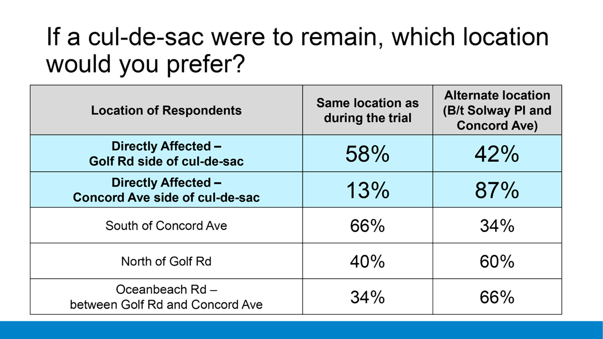
(1) There
was a significant difference in the responses of directly affected residents
based on which side of the cul-de-sac they were on.
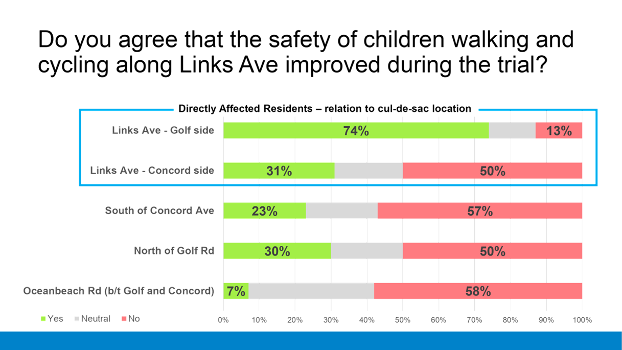
(a) When
asked if the trial had improved safety, 74% on the Golf Road side of the
cul-de-sac agreed, while only 31% on the Concord Avenue side did.
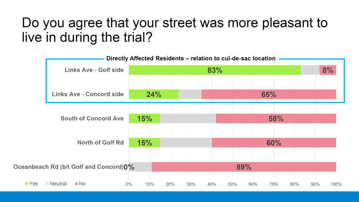
(b) When
asked if the trial had made their street more pleasant, 83% on the Golf Road
side of the cul-de-sac agreed, while only 24% on the Concord Avenue side did.
(c) When
asked if the cul-de-sac were to remain where should it be placed, 87% on the
Concord Avenue side said move it towards Concord Ave, while only 42% on the
Golf Road side did.
(d) Among
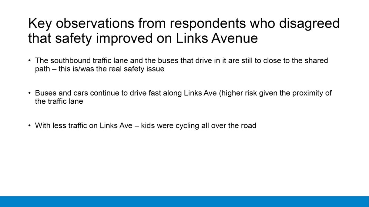
those who disagreed that the trial improved safety or enjoyability, almost all
commentary on why focused on:
(i) the
remaining bus lane and bus speeds
(ii) the
proximity of the southbound traffic lane to the shared path
(iii) the
impacts to travel time while driving from not having access to and from Golf
Road.
57. A
petition and survey with over 1000 participants led by the Papamoa Resident and
Ratepayers Association (PPRA) in conjunction with the Tauranga Ratepayers
Alliance (TRA) was presented to Council after the trial completed.
(a) 98%
stated they did not support the Links Ave cul-de-sac
(b) 67%
stated that Links Avenue should not have a bus lane. 48% said buses
should travel 15km/hr or less while 32% said the speed should be 40km/hr.
(c) 62%
supported installation of a barrier fence along the shared path to separate
pedestrians from the buses
(d) The
main themes of the commentary provided within the survey include:
(i) Frustration
about increased travel times within and traveling through Arataki
(ii) Impacts
on nearby roads such as increased traffic volumes and longer queues
(iii) A
feeling that their voices and desires are not listened to
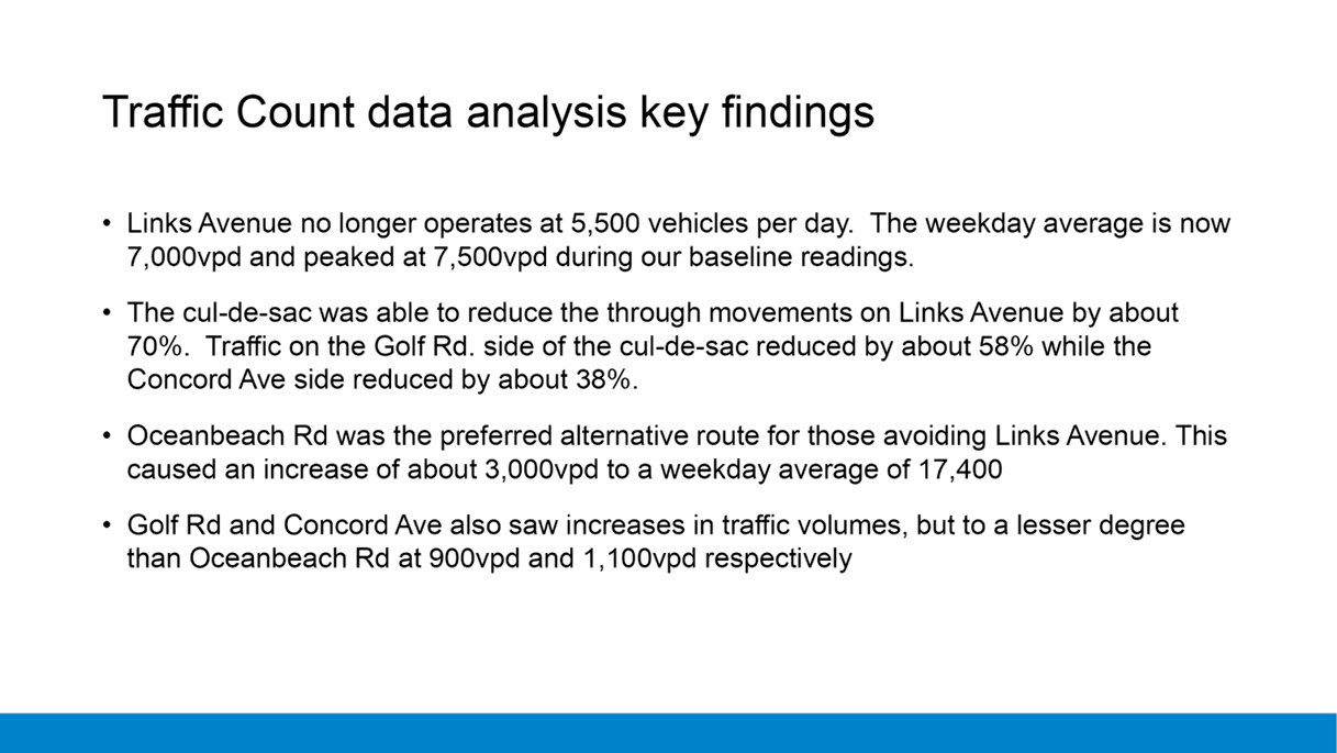
TRAFFIC COUNT DATA RESULTS
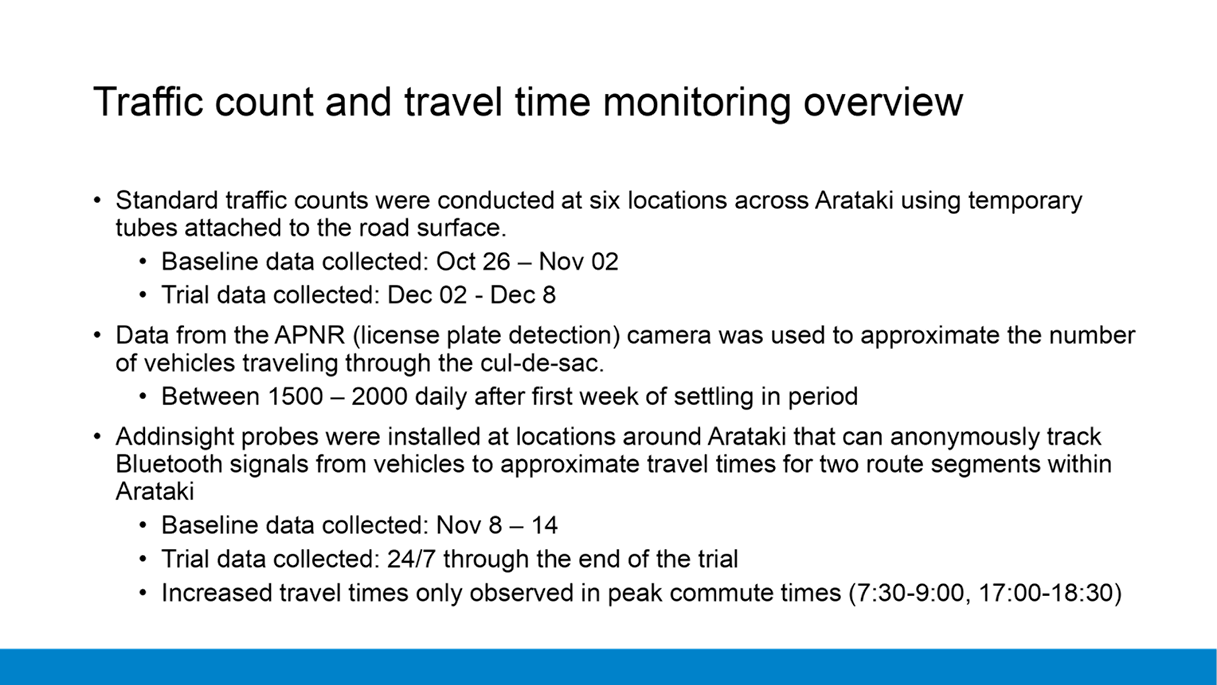
58. Six
locations in Arataki were chosen to conduct traffic counts to monitor the
effects of the cul-de-sac on traffic volumes. Baseline traffic counts were
conducted from October 27th – November 2nd and
trial traffic counts were conducted from December 7th –
December 13th.
59. For
Links Avenue, traffic counts were conducted on each side of the cul-de-sac, and
additional counts from the APNR provided data on the number of vehicles
entering and exiting the cul-de-sac.
60. The
key findings from the traffic count data are:
(a) The
traffic volume on Links Avenue is no longer averaging 5500 cars per day.
The baseline counts conducted confirmed the weekday average is now 7000 cars
per day with two days within the data collection period reaching 7500.
(b) The
cul-de-sac reduced through movements on Links Avenue by approximately
70%. However, there was a difference in the reduction in traffic volume
on either side of the cul-de-sac, with the northern end (Golf Rd.) achieving a
56% reduction while the southern end (Concord Rd.) achieved around 38%.
(c) Oceanbeach
Rd. became the preferred alternative route for diverted Links Avenue traffic.
This added an average of 3000 cars per day during the weekdays and 2400 cars on
the weekend
(d) Golf
Rd. and Concord Ave. also saw increases to traffic volumes, but the impacts
were less severe than that of Oceanbeach Rd.
(e) Grenada
St, which is commonly used in conjunction with Links Avenue as bypass route
through Arataki did not see any noticeable reduction or increase in traffic
volume
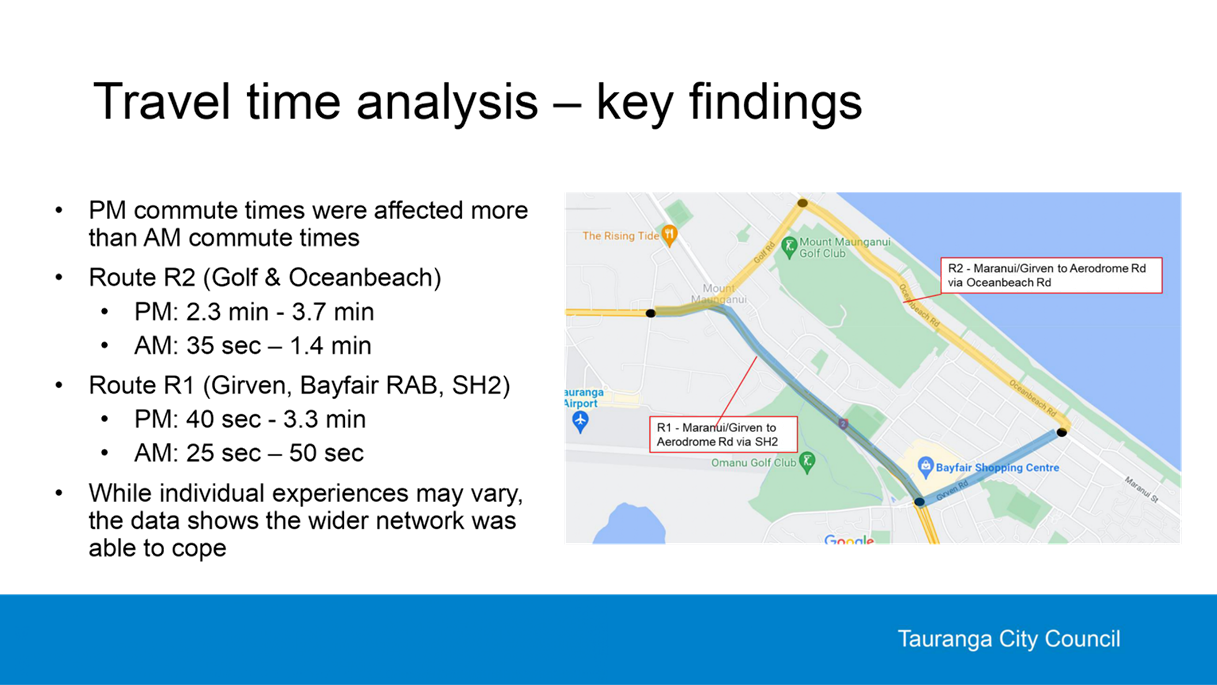
Travel Time Data Results
61.
Two route segments were selected as a proxy to monitor the impacts reducing
traffic volume on Links Avenue would have on the wider Arataki transport
network. Travel times were collected using technology that can anonymously
track and match Bluetooth signals of vehicles or their occupants.
62. Data collected
a week prior to the trial was used to establish a baseline, and travel times in
both directions of each route were collected each day during the trial. While
travel times were monitored 24 hours a day, impacts of the cul-de-sac on travel
times were only observed for a few hours a day Monday – Friday during the
peak commuting times (07:30-9:00 and 16:30–18:00).
63. Within each AM
and PM commute time window, the peak 60 minutes with the longest commute times
were aggregated daily and averaged by week to identify the largest time delays
and reduce uncommon or non-recurring events such as an accident.
64. The PM commute
(City/Mount towards Papamoa) was more impacted from the Links Avenue cul-de-sac
then the AM commute.
(a) Route
R2, which includes the Golf Rd / Maunganui Rd roundabout and Oceanbeach Rd was
the most affected route. In the week prior the trial, the average travel
time during the isolated commute window was 430 seconds (7.2 minutes).
During the trial, that travel time increased by 187 seconds (3.1
minutes).
(b) Route
R1, which includes the Hewletts Rd flyover and the Bayfair roundabout fared
slightly better, with baseline travel time at 603 seconds (10.1 minutes) with
trial travel times increased by 140 seconds (2.3 minutes).
65. The AM commute
(Papamoa towards the City/Mount) did not register large travel time increases
on the route segments that were measured.
(a) Route
R2 had a baseline travel time of 714 seconds (11.9 mins) which increased by 38
seconds (0.6 minutes) during the trial.
(b) Route
R1 had a baseline travel time of 711 seconds (11.9 mins) which increased by 14
seconds (0.2 minutes) during the trial.
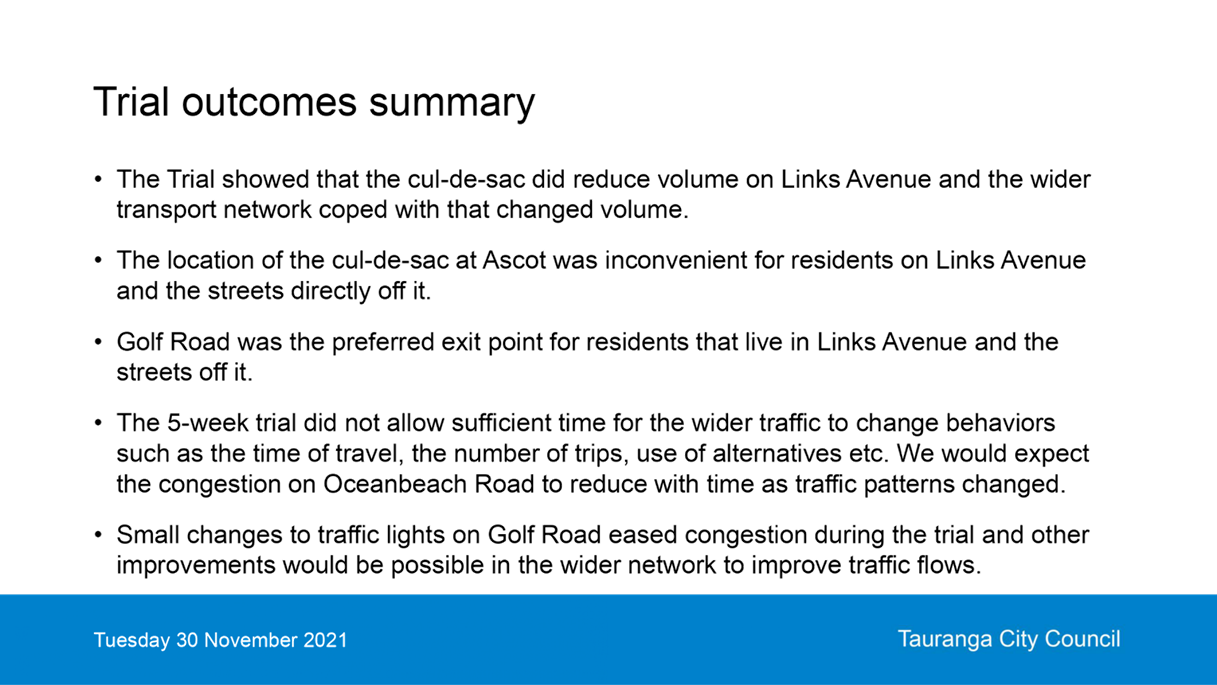
Overall Results of the Trial
66. The
cul-de-sac trial did achieve the safety outcomes sought. The trial showed that
the cul-de-sac did reduce the traffic volume substantially on Links Avenue and
if permanently implemented would allow the bus lane to be removed and make it
safer for people biking to use the road in addition to the shared path.
67. Due
to the short duration of the trial, the road layout on Links Avenue was not
changed and the bus lane was kept. This did prevent the residents being able to
see what could be achieved in the road layout if the bus lane was not required
and space reallocated.
68. The
wider traffic network did cope with the increased traffic flows and the travel
times recorded through the monitored sections were <1m in the morning peak
and 2-4minutes in the afternoon peak. There were increased queue lengths, but
that was expected as the traffic moved off Links Avenue.
69. The
location of the cul-de-sac at Ascot Rd. did cause some inconvenience for
residents in Links Avenue and the streets immediately off it, as those heading
towards the Mount needed to head in the opposite direction and use Oceanbeach
Rd. which further increased the volumes there.
70. Due
to the short duration of the initial trial, most of the traffic used Oceanbeach
Rd. rather than Maunganui Rd/SH2. We would expect to see traffic splitting
itself more evenly between the two routes if the trial had been longer.
Recommendation
71. The
first trial showed that a cul-de-sac achieves the traffic volume reduction, but
due to the short time frame we were not able to fully assess the network
impacts and the road layout on Links Avenue was not changed and therefore the
separation of the vehicles and shared path was not able to be tested. As a
result another trial is needed to fully explore the impact of a cul-de-sac. The
trial should be undertaken at the alternative location near Concord Avenue, so
residents are able to assess the impact on their travel activities. Links
Avenue should be posted at 30km/h during the period and appropriate temporary
traffic management measures installed to keep speeds at that level. This
temporary speed limit requires Waka Kotahi approval.
72. As
part of the trial, Links Avenue should be chip sealed so the existing bus lane
is removed, and the vehicle lane moved away from the shared path. This would
allow the community to discuss how they would like to see the road layout
including features such as street trees etc if this was to be permanently
implemented.
73. The
next trial needs to be a minimum 4 months. This will ensure that the wider
community has the opportunity to adjust travel times, consolidates the number
of daily journeys etc to better assess the road networks ability to cope which
did not occur with the initial 5 week trial.
74. To
ensure that the road remains safe until a decision is made on a permanent
solution, the cul-de-sac needs to remain in place until Council has time to
consider a report on the outcomes of the second trial.
75. Enforcement
of the bus lane restriction at the cul-de-sac will be required on a 24/7 basis
to ensure that the traffic volumes remain low. Drivers would be issued a
warning letter on the first offense prior to receiving the first ticket.
Tickets are $150 per offense and the fine value is set by the Government
76. At
the same time as the trial, a wider conversation with the community should be
started about the future of the transport system and how travel choices will
need to change as the city changes and grows.
77. Staff
would also review the road layout on key corridors to improve traffic flow and
would prioritise Oceanbeach Rd. so this could better accommodate any increased
traffic flow.
Financial
Considerations
78. Council will have sufficient
funding to undertake another trial from the original allocation. Activities
such as the chip sealing of the road during the trail will be covered from
existing maintenance budgets.
79. Council will be putting forward
Links Avenue as a project for the Streets for People fund recently announced by
Waka Kotahi (this replaces the Innovating Streets fund). If this was successful
it would provide 90% of the funding and allow Council to trial various road
layout’s, install street trees and talk to residents in Links Avenue and
the surrounding streets about their desire for the long-term layout of the road
allowing for the need to cater for walking and cycling and passenger transport
services.
Legal
Implications / Risks
80. The recommendation is for a further
trial. A change to the Council bylaws will be required to revoke the existing
bus lane and create the new bus lane cul-de-sac to allow enforcement. A bylaw
paper will be presented at the Council meeting on the 28th February
to make these changes.
Consultation
/ Engagement
81. Due to Covid restrictions, face to
face meetings with the community were not held during the initial trial, but
significant feedback was received from the community and Council have surveyed
the community about the trial in January.
82. With the recommended new trial,
consultation will be held with the directly affected residents on Links Avenue,
and the streets immediately off it, on road layout changes that could be
implemented if the cul-de-sac was permanent. Council would also undertake
similar surveys to the original trial to gauge wider community views on the new
trial. Monitoring of travel time and traffic volumes would also be undertaken.
Next
Steps
83. If a further cul-de-sac trail was
implemented, this would start in late February and continue through to a staff
report back to Council in August 2022.
Attachments
1. Links
Avenue presentation - A13220601 ⇩